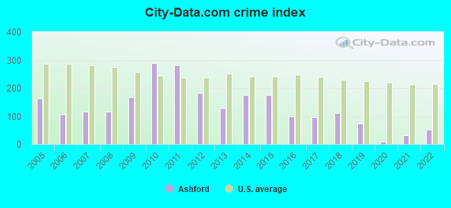
The City-Data.com crime index weighs serious crimes and violent crimes more heavily. Higher means more crime, U.S. average is 246.1. It adjusts for the number of visitors and daily workers commuting into cities.
Latest news from Ashford, AL collected exclusively by city-data.com from local newspapers, TV, and radio stations
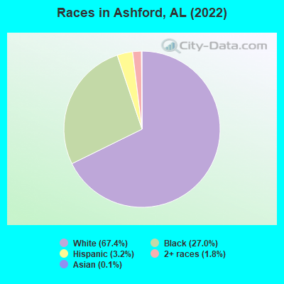
Ancestries: American (28.5%), English (14.3%), Irish (2.9%), Scottish (2.0%), Eastern European (1.9%), German (1.7%).
Current Local Time: CST time zone
Elevation: 276 feet
Land area: 6.10 square miles.
Population density: 372 people per square mile (very low).
15 residents are foreign born
This city:
0.6%
Alabama:
3.5%
Median real estate property taxes paid for housing units with mortgages in 2022: $534 (0.3%) Median real estate property taxes paid for housing units with no mortgage in 2022: $263 (0.2%)
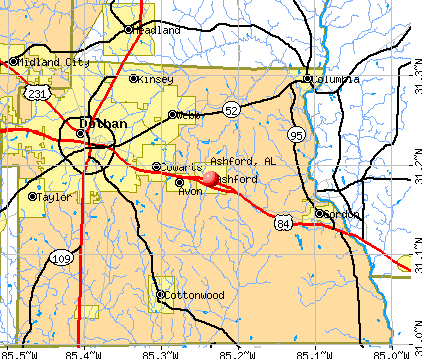
Nearest city with pop. 50,000+: Dothan, AL (10.6 miles , pop. 57,737).
Nearest city with pop. 200,000+: Montgomery, AL (102.0 miles , pop. 201,568).
Nearest city with pop. 1,000,000+: Houston, TX (612.6 miles , pop. 1,953,631).
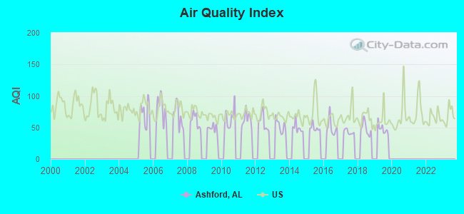
Air Quality Index (AQI) level in 2019 was 47.9. This is significantly better than average.
City:
47.9
U.S.:
72.6
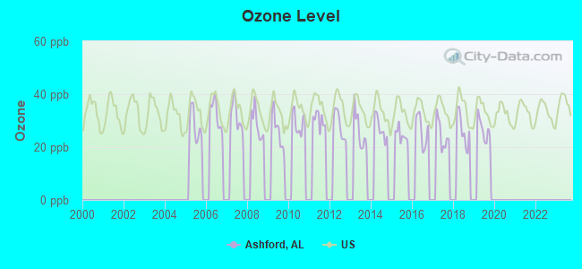
Ozone [ppb] level in 2019 was 26.7. This is better than average.Closest monitor was 11.1 miles away from the city center.
City:
26.7
U.S.:
33.3
Tornado activity:
Ashford-area historical tornado activity is slightly below Alabama state average. It is 52% greater than the overall U.S. average.
On 12/29/1973, a category F3 (max. wind speeds 158-206 mph) tornado 13.3 miles away from the Ashford city center injured 2 peopleand causedbetween $500,000 and $5,000,000 in damages.
On 3/1/2007, a category F4 (max. wind speeds 207-260 mph) tornado 41.0 miles away from the city center killed 9 peopleand injured 50 peopleand caused $250 million in damages.
Earthquake activity:
Ashford-area historical earthquake activity is significantly above Alabama state average. It is 2% greater than the overall U.S. average.
On 10/24/1997 at 08:35:17, a magnitude 4.9 (4.8 MB, 4.2 MS, 4.9 LG, Depth: 6.2 mi, Class: Light, Intensity: IV - V) earthquake occurred 120.6 miles away from the city center On 1/18/1999 at 07:00:53, a magnitude 4.8 (4.8 MB, 4.0 LG, Depth: 0.6 mi) earthquake occurred 193.8 miles away from Ashford center On 4/29/2003 at 08:59:39, a magnitude 4.9 (4.4 MB, 4.6 MW, 4.9 LG) earthquake occurred 230.1 miles away from the city center On 8/2/1974 at 08:52:09, a magnitude 4.9 (4.3 MB, 4.9 LG) earthquake occurred 245.4 miles away from the city center On 4/29/2003 at 08:59:39, a magnitude 4.6 (4.6 MW, Depth: 12.3 mi) earthquake occurred 230.1 miles away from Ashford center On 11/7/2004 at 11:20:21, a magnitude 4.3 (4.3 MW, Depth: 3.1 mi) earthquake occurred 188.0 miles away from the city center Magnitude types: regional Lg-wave magnitude (LG), body-wave magnitude (MB), surface-wave magnitude (MS), moment magnitude (MW)
Natural disasters:
The number of natural disasters in Houston County (21) is greater than the US average (15). Major Disasters (Presidential) Declared: 13 Emergencies Declared: 5
Causes of natural disasters: Storms: 10, Floods: 8, Tornadoes: 8, Hurricanes: 7, Winds: 5, Drought: 1, Snowfall: 1, Tropical Storm: 1, Winter Storm: 1, Other: 1 (Note: some incidents may be assigned to more than one category).
Hospitals and medical centers near Ashford:
SOUTHEAST ALABAMA MEDICAL CENTER Acute Care Hospitals (about 8 miles away; DOTHAN, AL)
DAVITA WIREGRASS KIDNEY CENTER (Dialysis Facility, about 8 miles away; DOTHAN, AL)
DCI DOTHAN (Dialysis Facility, about 9 miles away; DOTHAN, AL)
HOUSTON COUNTY HOME CARE (Home Health Center, about 9 miles away; DOTHAN, AL)
EXTENDICARE HEALTH CENTER (Nursing Home, about 10 miles away; DOTHAN, AL)
MID-SOUTH HOME HEALTH (Home Health Center, about 12 miles away; DOTHAN, AL)
COVENANT HOSPICE INC (Hospital, about 12 miles away; DOTHAN, AL)
Operable nuclear power plants near Ashford:
11 miles: Joseph M. Farley 1 and 2 in Dothan, AL.
Colleges/universities with over 2000 students nearest to Ashford:
George C Wallace State Community College-Dothan (about 17 miles; Dothan, AL; Full-time enrollment: 3,611)
Enterprise State Community College (about 37 miles; Enterprise, AL; FT enrollment: 2,101)
Bainbridge State College (about 46 miles; Bainbridge, GA; FT enrollment: 2,308)
Troy University (about 60 miles; Troy, AL; FT enrollment: 16,148)
Darton State College (about 67 miles; Albany, GA; FT enrollment: 5,000)
Albany Technical College (about 68 miles; Albany, GA; FT enrollment: 3,707)
Albany State University (about 70 miles; Albany, GA; FT enrollment: 3,662)
Public high schools in Ashford:
ASHFORD HIGH SCH(Students: 767, Location: 607 CHURCH ST, Grades: 7-12)
HOUSTON CO AREA VOC CTR (Location: 801 8TH AVE, Grades: 9-12)
Private high school in Ashford:
ASHFORD ACADEMY (Students: 158, Location: 1100 N BROADWAY ST, Grades: PK-12)
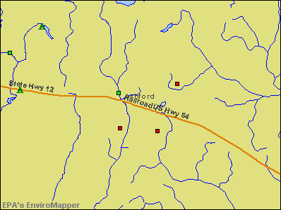
Notable locations in Ashford: Town of Ashford Sewage Lagoon (A), Ashford Ambulance / Rescue (B), Ashford Fire Department (C), Houston County Public Library Ashford Branch (D). Display/hide their locations on the map
Churches in Ashford include: Wayside Baptist Church (A), Ashford Assembly of God Church (B), Church of God and Christ (C), First Baptist Church (D), Ashford United Methodist Church (E), First Assembly of God Church (F), Mount Carmel Baptist Church (G), Grant Chapel African Methodist Episcopal Church (H). Display/hide their locations on the map
Tourist attraction: City of Ashford (Cultural Attractions- Events- & Facilities; 305 6th Avenue).
Houston County has a predicted average indoor radon screening level less than 2 pCi/L (pico curies per liter) - Low Potential
Drinking water stations with addresses in Ashford and their reported violations in the past:
ASHFORD WATER WORKS (Population served: 2,934, Groundwater):
Past monitoring violations:
Follow-up Or Routine LCR Tap M/R - In OCT-11-2005, Contaminant: Lead and Copper Rule. Follow-up actions: St Public Notif requested (DEC-16-2009), St Violation/Reminder Notice (DEC-16-2009), St Compliance achieved (NOV-16-2010), St Public Notif received (MAR-10-2011)
Drinking water stations with addresses in Ashford that have no violations reported:
AVON WATER SYSTEM (Population served: 465,Primary Water Source Type: Purch groundwater)
Average household size:
This city:
2.5 people
Alabama:
2.5 people
Percentage of family households:
This city:
71.9%
Whole state:
67.8%
Percentage of households with unmarried partners:
This city:
4.3%
Whole state:
4.7%
Likely homosexual households (counted as self-reported same-sex unmarried-partner households)
Lesbian couples: 0.5% of all households
Gay men: 0.2% of all households
Banks with branches in Ashford (2011 data):
MidSouth Bank, N. A.: Ashford Branch at 520 Bradway Street, branch established on 2003/01/01. Info updated 2006/11/03: Bank assets: $374.8 mil, Deposits: $334.2 mil, headquarters in Dothan, AL, positive income, Commercial Lending Specialization, 9 total offices, Holding Company: Midsouth Bancorporation
PeoplesSouth Bank: Ashford Branch at 414 Broadway, branch established on 1920/02/20. Info updated 2006/11/03: Bank assets: $534.5 mil, Deposits: $446.4 mil, headquarters in Colquitt, GA, positive income, Commercial Lending Specialization, 19 total offices, Holding Company: Peoplessouth Bancshares, Inc.
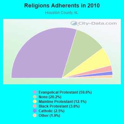
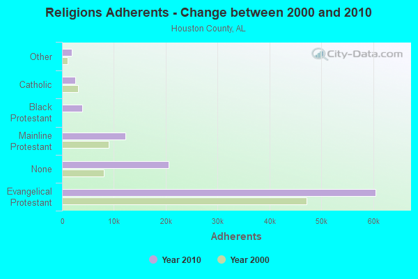
Religion statistics for Ashford, AL (based on Houston County data)
Religion
Adherents
Congregations
Evangelical Protestant
60,486
152
Mainline Protestant
12,245
31
Black Protestant
3,855
18
Catholic
2,551
1
Other
1,882
7
Orthodox
40
1
None
20,488
-
Source: Clifford Grammich, Kirk Hadaway, Richard Houseal, Dale E.Jones, Alexei Krindatch, Richie Stanley and Richard H.Taylor. 2012. 2010 U.S.Religion Census: Religious Congregations & Membership Study. Association of Statisticians of American Religious Bodies. Jones, Dale E., et al. 2002. Congregations and Membership in the United States 2000. Nashville, TN: Glenmary Research Center. Graphs represent county-level data
Aircraft: CESSNA 172H (Category: Land, Seats: 4, Weight: Up to 12,499 Pounds, Speed: 105 mph), Engine: CONT MOTOR 0-300 SER (145 HP) (Reciprocating) N-Number: 1680F, N1680F, N-1680F, Serial Number: 17255075, Year manufactured: 1966, Airworthiness Date: 09/19/1966, Certificate Issue Date: 07/14/2007 Registrant (Individual): Robert Wayne Boyette, 400 Leo Pynes Rd, Ashford, AL 36312
Aircraft: PIPER PA-28-140 (Category: Land, Seats: 4, Weight: Up to 12,499 Pounds, Speed: 107 mph), Engine: LYCOMING 0-320 SERIES (180 HP) (Reciprocating) N-Number: 1724J, N1724J, N-1724J, Serial Number: 28-24136, Year manufactured: 1968, Airworthiness Date: 01/09/1968, Certificate Issue Date: 05/15/2014 Registrant (Co-Owned): Ronald M Smith, 1715 Pansey Rd, Ashford, AL 36312, Other Owners: Joyce L Smith
Aircraft: BELL 47D1 (Category: Land, Seats: 3, Weight: Up to 12,499 Pounds, Speed: 78 mph), Engine: Reciprocating N-Number: 63300, N63300, N-63300, Serial Number: 841, Year manufactured: 1951, Airworthiness Date: 04/25/1978, Certificate Issue Date: 08/25/1983 Registrant (Individual): Tommy J Bassett, 325 Fowler Rd, Ashford, AL 36312
Aircraft: CONTINENTAL COPTERS INC TOMCAT MK5A (Category: Land, Seats: 3, Weight: Up to 12,499 Pounds), Engine: LYCOMING 0-435 (175 HP) (Reciprocating) N-Number: 9096T, N9096T, N-9096T, Serial Number: CCI-78-8, Year manufactured: 1978, Airworthiness Date: 12/13/1978, Certificate Issue Date: 06/20/2000 Registrant (Individual): Donald Bassett, 325 Fowler Rd, Ashford, AL 36312
Aircraft: CHARLES R WALLER MXII SPRINT (Category: Land, Seats: 2, Weight: Up to 12,499 Pounds), Engine: ROTAX 582SER (65 HP) (Reciprocating) N-Number: 933BW, N933BW, N-933BW, Serial Number: 0698, Year manufactured: 2013, Airworthiness Date: 11/27/2013, Certificate Issue Date: 08/20/2013 Registrant (Individual): Charles R Waller, 3664 S County 55 Rd, Ashford, AL 36312
Aircraft: WALLER CHARLES R RANS S12-XL (Category: Land, Seats: 2, Weight: Up to 12,499 Pounds), Engine: ROTAX SEE BOMBADIER (Reciprocating) N-Number: 933CW, N933CW, N-933CW, Serial Number: 03030963, Year manufactured: 2002, Airworthiness Date: 12/18/2004, Certificate Issue Date: 02/11/2019 Registrant (Individual): Brian R Waller, 3664 S County Road 55, Ashford, AL 36312
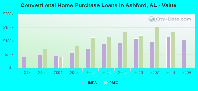
Home Mortgage Disclosure Act Aggregated Statistics For Year 2009 (Based on 1 partial tract)
A) FHA, FSA/RHS & VA Home Purchase Loans
B) Conventional Home Purchase Loans
C) Refinancings
D) Home Improvement Loans
F) Non-occupant Loans on < 5 Family Dwellings (A B C & D)
G) Loans On Manufactured Home Dwelling (A B C & D)
Number
Average Value
Number
Average Value
Number
Average Value
Number
Average Value
Number
Average Value
Number
Average Value
LOANS ORIGINATED
2
$94,265
2
$104,310
12
$140,476
1
$32,600
2
$79,465
1
$71,540
APPLICATIONS APPROVED, NOT ACCEPTED
0
$0
0
$0
0
$0
0
$0
0
$0
0
$0
APPLICATIONS DENIED
0
$0
1
$76,740
4
$162,038
1
$53,390
0
$0
2
$38,190
APPLICATIONS WITHDRAWN
0
$0
0
$0
3
$135,380
0
$0
0
$0
0
$0
FILES CLOSED FOR INCOMPLETENESS
0
$0
0
$0
1
$164,480
0
$0
0
$0
0
$0
Aggregated Statistics For Year 2008 (Based on 1 partial tract)
A) FHA, FSA/RHS & VA Home Purchase Loans
B) Conventional Home Purchase Loans
C) Refinancings
D) Home Improvement Loans
F) Non-occupant Loans on < 5 Family Dwellings (A B C & D)
G) Loans On Manufactured Home Dwelling (A B C & D)
Number
Average Value
Number
Average Value
Number
Average Value
Number
Average Value
Number
Average Value
Number
Average Value
LOANS ORIGINATED
3
$107,570
4
$115,410
10
$109,975
2
$48,280
2
$72,420
1
$60,350
APPLICATIONS APPROVED, NOT ACCEPTED
0
$0
1
$36,390
1
$128,100
0
$0
0
$0
1
$40,700
APPLICATIONS DENIED
1
$141,750
2
$91,580
8
$113,924
1
$117,440
0
$0
3
$60,760
APPLICATIONS WITHDRAWN
0
$0
0
$0
2
$157,215
0
$0
0
$0
0
$0
FILES CLOSED FOR INCOMPLETENESS
0
$0
0
$0
1
$130,120
0
$0
0
$0
0
$0
Aggregated Statistics For Year 2007 (Based on 1 partial tract)
A) FHA, FSA/RHS & VA Home Purchase Loans
B) Conventional Home Purchase Loans
C) Refinancings
D) Home Improvement Loans
F) Non-occupant Loans on < 5 Family Dwellings (A B C & D)
G) Loans On Manufactured Home Dwelling (A B C & D)
Number
Average Value
Number
Average Value
Number
Average Value
Number
Average Value
Number
Average Value
Number
Average Value
LOANS ORIGINATED
2
$108,670
7
$95,086
11
$99,441
2
$41,805
3
$57,353
2
$34,535
APPLICATIONS APPROVED, NOT ACCEPTED
0
$0
2
$77,350
1
$140,170
0
$0
0
$0
1
$55,060
APPLICATIONS DENIED
0
$0
4
$82,638
5
$104,328
2
$44,225
0
$0
2
$53,210
APPLICATIONS WITHDRAWN
0
$0
1
$47,050
2
$107,700
0
$0
0
$0
0
$0
FILES CLOSED FOR INCOMPLETENESS
0
$0
0
$0
1
$135,760
0
$0
0
$0
0
$0
Aggregated Statistics For Year 2006 (Based on 1 partial tract)
A) FHA, FSA/RHS & VA Home Purchase Loans
B) Conventional Home Purchase Loans
C) Refinancings
D) Home Improvement Loans
F) Non-occupant Loans on < 5 Family Dwellings (A B C & D)
G) Loans On Manufactured Home Dwelling (A B C & D)
Number
Average Value
Number
Average Value
Number
Average Value
Number
Average Value
Number
Average Value
Number
Average Value
LOANS ORIGINATED
2
$102,680
6
$109,523
9
$97,791
2
$24,890
1
$103,960
1
$53,300
APPLICATIONS APPROVED, NOT ACCEPTED
0
$0
1
$69,420
1
$130,040
0
$0
0
$0
1
$41,050
APPLICATIONS DENIED
0
$0
3
$69,803
7
$85,721
3
$37,853
1
$57,440
2
$53,695
APPLICATIONS WITHDRAWN
0
$0
1
$100,610
3
$113,503
1
$46,520
0
$0
0
$0
FILES CLOSED FOR INCOMPLETENESS
0
$0
0
$0
1
$152,770
0
$0
0
$0
0
$0
Aggregated Statistics For Year 2005 (Based on 1 partial tract)
A) FHA, FSA/RHS & VA Home Purchase Loans
B) Conventional Home Purchase Loans
C) Refinancings
D) Home Improvement Loans
F) Non-occupant Loans on < 5 Family Dwellings (A B C & D)
G) Loans On Manufactured Home Dwelling (A B C & D)
Number
Average Value
Number
Average Value
Number
Average Value
Number
Average Value
Number
Average Value
Number
Average Value
LOANS ORIGINATED
2
$132,150
7
$91,889
10
$80,338
2
$18,280
2
$38,370
3
$24,373
APPLICATIONS APPROVED, NOT ACCEPTED
0
$0
1
$89,250
2
$94,445
0
$0
0
$0
1
$32,860
APPLICATIONS DENIED
0
$0
4
$42,265
6
$93,253
2
$31,365
0
$0
3
$38,470
APPLICATIONS WITHDRAWN
0
$0
1
$75,330
3
$110,360
1
$58,150
1
$35,420
0
$0
FILES CLOSED FOR INCOMPLETENESS
0
$0
0
$0
1
$68,810
0
$0
0
$0
0
$0
Aggregated Statistics For Year 2004 (Based on 1 partial tract)
A) FHA, FSA/RHS & VA Home Purchase Loans
B) Conventional Home Purchase Loans
C) Refinancings
D) Home Improvement Loans
F) Non-occupant Loans on < 5 Family Dwellings (A B C & D)
G) Loans On Manufactured Home Dwelling (A B C & D)
Number
Average Value
Number
Average Value
Number
Average Value
Number
Average Value
Number
Average Value
Number
Average Value
LOANS ORIGINATED
1
$98,500
6
$88,378
11
$85,985
2
$22,555
2
$45,855
2
$25,770
APPLICATIONS APPROVED, NOT ACCEPTED
0
$0
0
$0
2
$100,830
0
$0
0
$0
0
$0
APPLICATIONS DENIED
0
$0
3
$42,553
6
$69,217
2
$23,125
0
$0
2
$44,755
APPLICATIONS WITHDRAWN
0
$0
0
$0
3
$109,713
0
$0
0
$0
0
$0
FILES CLOSED FOR INCOMPLETENESS
0
$0
0
$0
1
$113,300
0
$0
0
$0
0
$0
Aggregated Statistics For Year 2003 (Based on 1 partial tract)
A) FHA, FSA/RHS & VA Home Purchase Loans
B) Conventional Home Purchase Loans
C) Refinancings
D) Home Improvement Loans
F) Non-occupant Loans on < 5 Family Dwellings (A B C & D)
Number
Average Value
Number
Average Value
Number
Average Value
Number
Average Value
Number
Average Value
LOANS ORIGINATED
2
$75,195
5
$69,776
18
$91,991
1
$42,550
2
$49,290
APPLICATIONS APPROVED, NOT ACCEPTED
0
$0
1
$34,620
3
$70,863
0
$0
0
$0
APPLICATIONS DENIED
0
$0
3
$49,130
7
$94,746
2
$21,980
1
$63,080
APPLICATIONS WITHDRAWN
1
$43,260
0
$0
4
$104,200
0
$0
0
$0
FILES CLOSED FOR INCOMPLETENESS
0
$0
0
$0
1
$45,990
0
$0
0
$0
Aggregated Statistics For Year 2002 (Based on 1 partial tract)
A) FHA, FSA/RHS & VA Home Purchase Loans
B) Conventional Home Purchase Loans
C) Refinancings
D) Home Improvement Loans
F) Non-occupant Loans on < 5 Family Dwellings (A B C & D)
Number
Average Value
Number
Average Value
Number
Average Value
Number
Average Value
Number
Average Value
LOANS ORIGINATED
2
$64,180
5
$55,168
13
$82,488
2
$44,180
2
$31,100
APPLICATIONS APPROVED, NOT ACCEPTED
0
$0
0
$0
1
$82,110
0
$0
0
$0
APPLICATIONS DENIED
0
$0
3
$35,093
5
$66,904
1
$20,170
0
$0
APPLICATIONS WITHDRAWN
0
$0
1
$41,230
2
$68,320
0
$0
0
$0
FILES CLOSED FOR INCOMPLETENESS
0
$0
0
$0
1
$100,700
0
$0
0
$0
Aggregated Statistics For Year 2001 (Based on 1 partial tract)
A) FHA, FSA/RHS & VA Home Purchase Loans
B) Conventional Home Purchase Loans
C) Refinancings
D) Home Improvement Loans
F) Non-occupant Loans on < 5 Family Dwellings (A B C & D)
Number
Average Value
Number
Average Value
Number
Average Value
Number
Average Value
Number
Average Value
LOANS ORIGINATED
1
$94,360
5
$44,456
13
$71,192
2
$21,010
1
$40,170
APPLICATIONS APPROVED, NOT ACCEPTED
0
$0
2
$47,310
1
$80,700
0
$0
0
$0
APPLICATIONS DENIED
0
$0
6
$44,535
3
$50,157
1
$17,180
0
$0
APPLICATIONS WITHDRAWN
0
$0
1
$31,890
2
$69,645
0
$0
0
$0
FILES CLOSED FOR INCOMPLETENESS
0
$0
0
$0
0
$0
0
$0
0
$0
Aggregated Statistics For Year 2000 (Based on 1 partial tract)
A) FHA, FSA/RHS & VA Home Purchase Loans
B) Conventional Home Purchase Loans
C) Refinancings
D) Home Improvement Loans
F) Non-occupant Loans on < 5 Family Dwellings (A B C & D)
Number
Average Value
Number
Average Value
Number
Average Value
Number
Average Value
Number
Average Value
LOANS ORIGINATED
1
$108,010
8
$48,091
6
$57,397
2
$35,195
1
$37,090
APPLICATIONS APPROVED, NOT ACCEPTED
0
$0
2
$55,990
1
$63,080
0
$0
0
$0
APPLICATIONS DENIED
0
$0
8
$41,186
2
$65,020
0
$0
0
$0
APPLICATIONS WITHDRAWN
0
$0
1
$52,770
1
$69,950
0
$0
0
$0
FILES CLOSED FOR INCOMPLETENESS
0
$0
0
$0
0
$0
0
$0
0
$0
Aggregated Statistics For Year 1999 (Based on 1 partial tract)
A) FHA, FSA/RHS & VA Home Purchase Loans
B) Conventional Home Purchase Loans
C) Refinancings
D) Home Improvement Loans
F) Non-occupant Loans on < 5 Family Dwellings (A B C & D)
Detailed PMIC statistics for the following Tracts:0419.00
2003 - 2018 National Fire Incident Reporting System (NFIRS) incidents
According to the data from the years 2003 - 2018 the average number of fire incidents per year is 15. The highest number of reported fire incidents - 31 took place in 2008, and the least - 1 in 2003. The data has a growing trend.
When looking into fire subcategories, the most incidents belonged to: Outside Fires (47.2%), and Structure Fires (42.6%).
Fire incident types reported to NFIRS in Ashford, AL


 Recent articles from our blog. Our writers, many of them Ph.D. graduates or candidates, create easy-to-read articles on a wide variety of topics.


 (10.6 miles


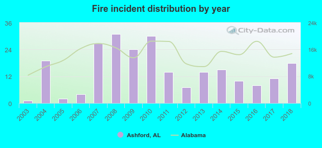 According to the data from the years 2003 - 2018 the average number of fire incidents per year is 15. The highest number of reported fire incidents - 31 took place in 2008, and the least - 1 in 2003. The data has a growing trend.
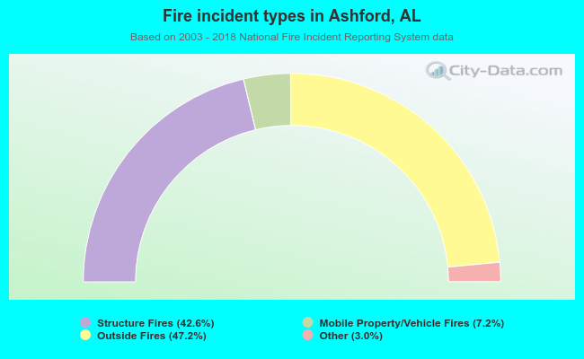 When looking into fire subcategories, the most incidents belonged to: Outside Fires (47.2%), and Structure Fires (42.6%).