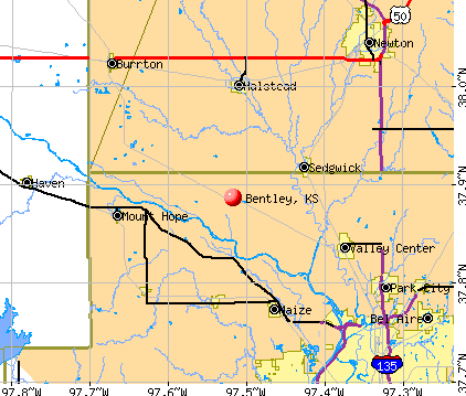
Bentley, Kansas
Submit your own pictures of this city and show them to the world
- OSM Map
- General Map
- Google Map
- MSN Map
Population change since 2000: +53.5%
| Males: 261 | |
| Females: 304 |
| Median resident age: | 43.3 years |
| Kansas median age: | 37.6 years |
Zip codes: 67016.
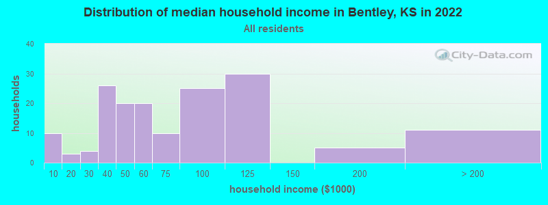
| Bentley: | $56,545 |
| KS: | $68,925 |
Estimated per capita income in 2022: $34,370 (it was $16,111 in 2000)
Bentley city income, earnings, and wages data
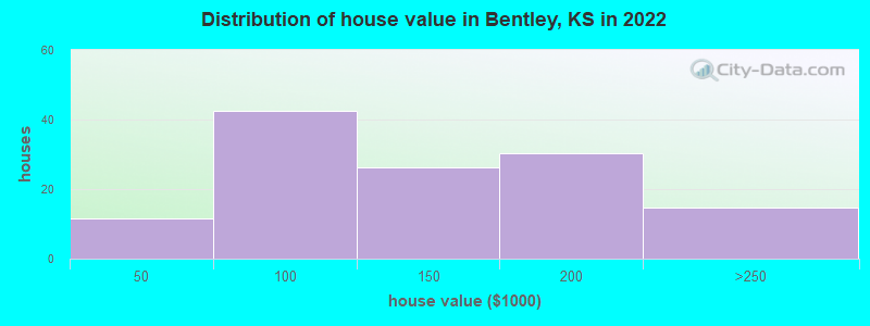
Estimated median house or condo value in 2022: $122,761 (it was $49,600 in 2000)
| Bentley: | $122,761 |
| KS: | $206,600 |
Mean prices in 2022: all housing units: $145,121; detached houses: $147,055; mobile homes: $100,744
Median gross rent in 2022: $979.
(5.8% for White Non-Hispanic residents, 70.1% for Hispanic or Latino residents)
Detailed information about poverty and poor residents in Bentley, KS
Compare current foreclosures near Bentley, KS:
| Photo | Address | Area | Beds / Baths | Price | Details |
|---|---|---|---|---|---|

|
#1
N Wichita St
Bentley, KS 67016
|
- sq. feet
|
- baths - beds |
show details | |

|
#2
S Devinshire Ave
Bentley, KS 67016
|
- sq. feet
|
- baths - beds |
show details | |

|
#3
Raymond Dr # 255
Bentley, KS 67016
|
- sq. feet
|
- baths - beds |
show details | |

|
#4
S Devinshire Ave
Bentley, KS 67016
|
- sq. feet
|
- baths - beds |
show details | |

|
#5
E 5th St
Newton, KS 67114
|
3,140 sq. feet
|
3 baths 4 beds |
show details | |

|
#6
N Jackson Ave
Wichita, KS 67203
|
756 sq. feet
|
1 baths 2 beds |
show details | |

|
#7
Berry Ave
Newton, KS 67114
|
828 sq. feet
|
1 baths 3 beds |
show details | |

|
#8
N Covington St
Wichita, KS 67212
|
1,242 sq. feet
|
3 baths 3 beds |
show details | |

|
#9
S Goddard Rd
Goddard, KS 67052
|
1,054 sq. feet
|
2 baths 2 beds |
show details | |

|
#10
E Cambridge St
Wichita, KS 67219
|
918 sq. feet
|
2 baths 3 beds |
show details |
| Photo | Address | Area | Beds / Baths | Price | Details |
|---|---|---|---|---|---|

|
#11
N Verda St
Wichita, KS 67203
|
1,880 sq. feet
|
2 baths 3 beds |
show details | |

|
#12
N Hood St
Wichita, KS 67203
|
798 sq. feet
|
1 baths 2 beds |
show details | |

|
#13
N Custer St
Wichita, KS 67203
|
1,241 sq. feet
|
2 baths 3 beds |
show details | |

|
#14
W 10th St N
Wichita, KS 67203
|
1,049 sq. feet
|
2 baths 3 beds |
show details | |

|
#15
E 3rd St
Newton, KS 67114
|
872 sq. feet
|
1 baths 2 beds |
show details | |

|
#16
N Summitlawn St
Wichita, KS 67212
|
1,092 sq. feet
|
1 baths 3 beds |
show details | |

|
#17
N Anderson Ave
Newton, KS 67114
|
1,488 sq. feet
|
2 baths 4 beds |
show details | |

|
#18
S Fawnwood St
Wichita, KS 67235
|
1,524 sq. feet
|
3 baths 3 beds |
show details | |

|
#19
S Ashley Park
Wichita, KS 67209
|
2,086 sq. feet
|
2 baths 3 beds |
show details | |

|
#20
N Walnut St
Newton, KS 67114
|
1,500 sq. feet
|
1 baths 3 beds |
show details |
| Photo | Address | Area | Beds / Baths | Price | Details |
|---|---|---|---|---|---|

|
#21
E 7th St
Newton, KS 67114
|
1,331 sq. feet
|
1 baths 4 beds |
show details | |

|
#22
S Tyler Rd Ste 506
Wichita, KS 67209
|
900 sq. feet
|
1 baths 2 beds |
show details | |

|
#23
N Woodland St
Wichita, KS 67203
|
1,144 sq. feet
|
1 baths 3 beds |
show details | |

|
#24
N Coolidge Ave
Wichita, KS 67203
|
1,199 sq. feet
|
1 baths 2 beds |
show details | |

|
#25
E 8th St
Newton, KS 67114
|
1,010 sq. feet
|
1 baths 2 beds |
show details | |

|
#26
E Winterset St
Goddard, KS 67052
|
816 sq. feet
|
1 baths 2 beds |
show details | |

|
#27
N Clarence Ave
Wichita, KS 67203
|
1,527 sq. feet
|
1 baths 3 beds |
show details | |

|
#28
W Rolling Hills Dr
Wichita, KS 67212
|
1,533 sq. feet
|
2 baths 3 beds |
show details | |

|
#29
W Shade Ln
Wichita, KS 67212
|
712 sq. feet
|
1 baths 1 beds |
show details | |

|
#30
N Wedgewood Dr
Wichita, KS 67204
|
1,012 sq. feet
|
1 baths 2 beds |
show details |
| Photo | Address | Area | Beds / Baths | Price | Details |
|---|---|---|---|---|---|

|
#31
W 10th St N
Wichita, KS 67212
|
1,307 sq. feet
|
1 baths 3 beds |
show details | |

|
#32
N Porter Ave
Wichita, KS 67204
|
1,522 sq. feet
|
2 baths 2 beds |
show details | |

|
#33
W Manhattan Dr
Wichita, KS 67204
|
1,461 sq. feet
|
1 baths 3 beds |
show details | |

|
#34
N Clarence Ave
Wichita, KS 67204
|
1,935 sq. feet
|
2 baths 4 beds |
show details | |

|
#35
W Birch Ln
Wichita, KS 67212
|
1,564 sq. feet
|
2 baths 3 beds |
show details | |

|
#36
N Chipper Ln
Wichita, KS 67212
|
1,756 sq. feet
|
2 baths 3 beds |
show details | |

|
#37
N Chipper Ln
Wichita, KS 67212
|
1,211 sq. feet
|
1 baths 3 beds |
show details | |

|
#38
N Joann St
Wichita, KS 67203
|
1,164 sq. feet
|
1 baths 3 beds |
show details | |

|
#39
N Shawnee Cir
Kechi, KS 67067
|
2,018 sq. feet
|
3 baths 2 beds |
show details | |

|
#40
W 9th St N
Wichita, KS 67212
|
816 sq. feet
|
1 baths 2 beds |
show details |
| Photo | Address | Area | Beds / Baths | Price | Details |
|---|---|---|---|---|---|

|
#41
W Hardtner Ave
Wichita, KS 67212
|
1,142 sq. feet
|
2 baths 3 beds |
show details | |

|
#42
N Sheridan St
Wichita, KS 67203
|
960 sq. feet
|
1 baths 3 beds |
show details | |

|
#43
N Litchfield Ave
Wichita, KS 67204
|
993 sq. feet
|
1 baths 2 beds |
show details | |

|
#44
N Coolidge Ave
Wichita, KS 67204
|
1,972 sq. feet
|
2 baths 3 beds |
show details | |

|
#45
N Payne Ave
Wichita, KS 67204
|
1,230 sq. feet
|
1 baths 3 beds |
show details | |

|
#46
W Broadway St
Newton, KS 67114
|
1,592 sq. feet
|
2 baths 2 beds |
show details | |

|
#47
W Broadway St
Newton, KS 67114
|
825 sq. feet
|
1 baths 2 beds |
show details | |

|
#48
N Westridge Dr
Wichita, KS 67203
|
1,080 sq. feet
|
1 baths 3 beds |
show details | |

|
#49
N Sheridan St
Wichita, KS 67203
|
864 sq. feet
|
1 baths 2 beds |
show details | |

|
Check over 1 million property listings on Foreclosure.com!
|
browse all offers | |||


- 35578.2%White alone
- 8017.6%Hispanic
- 194.2%Two or more races
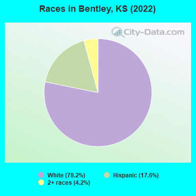
Races in Bentley detailed stats: ancestries, foreign born residents, place of birth
According to our research of Kansas and other state lists, there were 3 registered sex offenders living in Bentley, Kansas as of May 12, 2024.
The ratio of all residents to sex offenders in Bentley is 170 to 1.
Type |
2010 |
2011 |
2012 |
2013 |
2014 |
2015 |
2016 |
2018 |
|---|---|---|---|---|---|---|---|---|
| Murders (per 100,000) | 0 (0.0) | 0 (0.0) | 0 (0.0) | 0 (0.0) | 0 (0.0) | 0 (0.0) | 0 (0.0) | 0 (0.0) |
| Rapes (per 100,000) | 0 (0.0) | 1 (187.6) | 0 (0.0) | 0 (0.0) | 0 (0.0) | 0 (0.0) | 0 (0.0) | 0 (0.0) |
| Robberies (per 100,000) | 0 (0.0) | 0 (0.0) | 0 (0.0) | 0 (0.0) | 0 (0.0) | 0 (0.0) | 0 (0.0) | 0 (0.0) |
| Assaults (per 100,000) | 0 (0.0) | 0 (0.0) | 1 (186.2) | 0 (0.0) | 0 (0.0) | 0 (0.0) | 0 (0.0) | 0 (0.0) |
| Burglaries (per 100,000) | 0 (0.0) | 1 (187.6) | 0 (0.0) | 0 (0.0) | 0 (0.0) | 0 (0.0) | 0 (0.0) | 1 (190.8) |
| Thefts (per 100,000) | 5 (943.4) | 3 (562.9) | 0 (0.0) | 1 (189.8) | 0 (0.0) | 1 (191.2) | 3 (574.7) | 3 (572.5) |
| Auto thefts (per 100,000) | 1 (188.7) | 0 (0.0) | 0 (0.0) | 0 (0.0) | 0 (0.0) | 0 (0.0) | 0 (0.0) | 0 (0.0) |
| Arson (per 100,000) | 0 (0.0) | 0 (0.0) | 0 (0.0) | 0 (0.0) | 0 (0.0) | 0 (0.0) | 0 (0.0) | 0 (0.0) |
| City-Data.com crime index | 52.8 | 185.7 | 37.2 | 7.6 | 0.0 | 7.6 | 23.0 | 36.3 |
The City-Data.com crime index weighs serious crimes and violent crimes more heavily. Higher means more crime, U.S. average is 246.1. It adjusts for the number of visitors and daily workers commuting into cities.
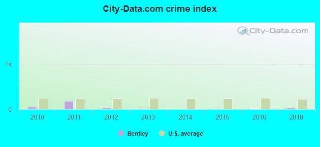
Crime rate in Bentley detailed stats: murders, rapes, robberies, assaults, burglaries, thefts, arson
 Recent articles from our blog. Our writers, many of them Ph.D. graduates or candidates, create easy-to-read articles on a wide variety of topics.

 | Think about moving to Wichita from Denver Colorado (40 replies) |
| need info on schools, rental housing, dance studios, orthodontist, etc. (8 replies) |
Latest news from Bentley, KS collected exclusively by city-data.com from local newspapers, TV, and radio stations
Ancestries: American (21.5%), German (18.1%), English (7.7%), Danish (3.8%), European (3.8%), Irish (3.1%).
Current Local Time: CST time zone
Elevation: 1387 feet
Land area: 0.22 square miles.
Population density: 2,619 people per square mile (average).
39 residents are foreign born (8.6% Latin America).
| This city: | 8.6% |
| Kansas: | 7.1% |
Median real estate property taxes paid for housing units with mortgages in 2022: $2,613 (1.7%)
Median real estate property taxes paid for housing units with no mortgage in 2022: $1,277 (1.4%)
Nearest city with pop. 50,000+: Wichita, KS  (16.9 miles , pop. 344,284).
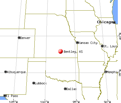
Nearest city with pop. 1,000,000+: Dallas, TX (354.2 miles , pop. 1,188,580).
Nearest cities:
), Latitude: 37.89 N, Longitude: 97.52 W
Area code commonly used in this area: 316

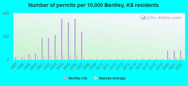
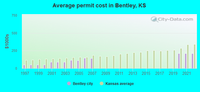
Single-family new house construction building permits:
- 2022: 3 buildings, average cost: $213,300
- 2021: 3 buildings, average cost: $213,300
- 2020: 3 buildings, average cost: $213,300
- 2007: 9 buildings, average cost: $145,100
- 2006: 13 buildings, average cost: $149,400
- 2005: 12 buildings, average cost: $110,500
- 2004: 13 buildings, average cost: $117,400
- 2003: 8 buildings, average cost: $89,700
- 2002: 7 buildings, average cost: $89,700
- 2001: 7 buildings, average cost: $89,700
- 2000: 2 buildings, average cost: $50,000
- 1999: 2 buildings, average cost: $50,000
- 1998: 1 building, cost: $50,000
- 1997: 1 building, cost: $50,000
| Here: | 2.4% |
| Kansas: | 2.0% |
- Transportation equipment (14.8%)
- Construction (10.3%)
- Health care (8.4%)
- Machinery (4.9%)
- Printing & related support activities (4.9%)
- Food & beverage stores (4.9%)
- Miscellaneous manufacturing (3.9%)
- Transportation equipment (23.1%)
- Construction (16.2%)
- Printing & related support activities (6.0%)
- Miscellaneous manufacturing (5.1%)
- Machinery (5.1%)
- Administrative & support & waste management services (5.1%)
- Health care (4.3%)
- Health care (14.0%)
- Educational services (8.1%)
- Food & beverage stores (7.0%)
- Accommodation & food services (5.8%)
- Personal & laundry services (4.7%)
- Social assistance (4.7%)
- Machinery (4.7%)
- Metal workers and plastic workers (10.8%)
- Other production occupations, including supervisors (7.4%)
- Cashiers (5.4%)
- Construction traders workers except carpenters, electricians, painters, plumbers, and construction laborers (4.9%)
- Material recording, scheduling, dispatching, and distributing workers (4.4%)
- Secretaries and administrative assistants (4.4%)
- Building and grounds cleaning and maintenance occupations (4.4%)
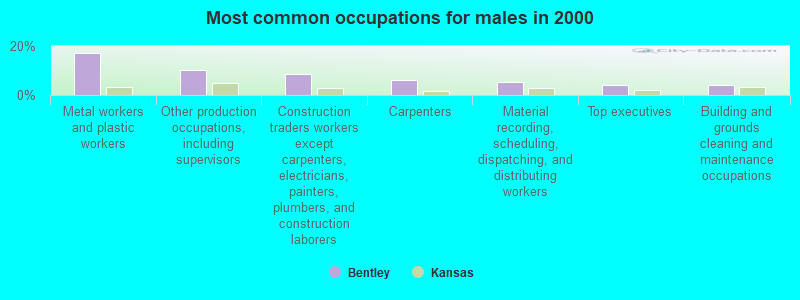
- Metal workers and plastic workers (17.1%)
- Other production occupations, including supervisors (10.3%)
- Construction traders workers except carpenters, electricians, painters, plumbers, and construction laborers (8.5%)
- Carpenters (6.0%)
- Material recording, scheduling, dispatching, and distributing workers (5.1%)
- Top executives (4.3%)
- Building and grounds cleaning and maintenance occupations (4.3%)
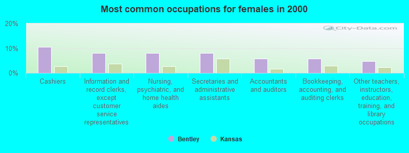
- Cashiers (10.5%)
- Information and record clerks, except customer service representatives (8.1%)
- Nursing, psychiatric, and home health aides (8.1%)
- Secretaries and administrative assistants (8.1%)
- Accountants and auditors (5.8%)
- Bookkeeping, accounting, and auditing clerks (5.8%)
- Other teachers, instructors, education, training, and library occupations (4.7%)
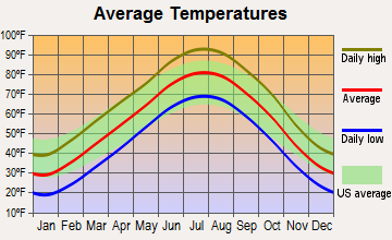
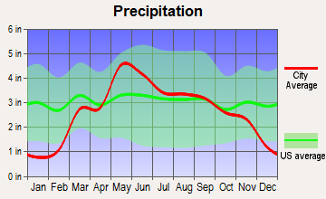
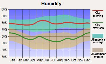
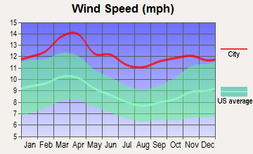
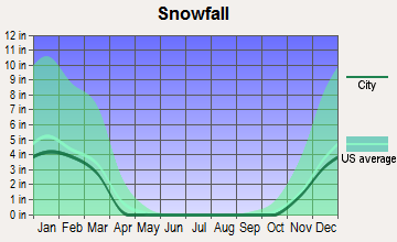
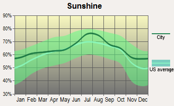
Average climate in Bentley, Kansas
Based on data reported by over 4,000 weather stations
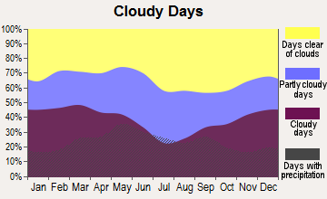
(lower is better)
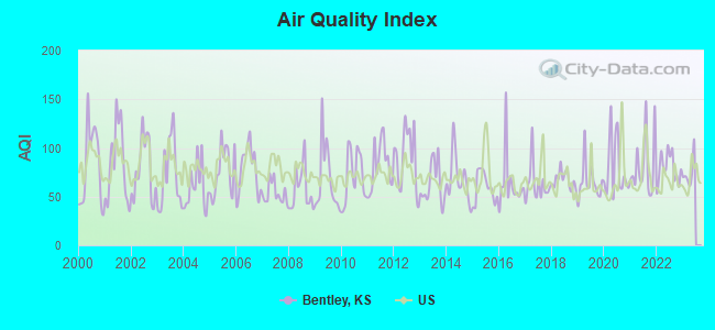
Air Quality Index (AQI) level in 2022 was 79.1. This is about average.
| City: | 79.1 |
| U.S.: | 72.6 |
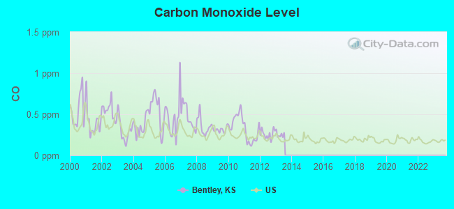
Carbon Monoxide (CO) [ppm] level in 2013 was 0.252. This is about average. Closest monitor was 15.7 miles away from the city center.
| City: | 0.252 |
| U.S.: | 0.251 |
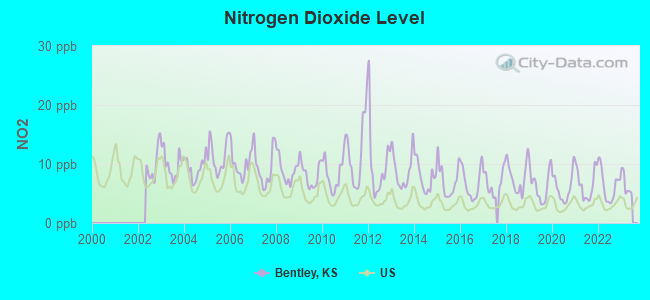
Nitrogen Dioxide (NO2) [ppb] level in 2022 was 6.32. This is worse than average. Closest monitor was 13.9 miles away from the city center.
| City: | 6.32 |
| U.S.: | 5.11 |
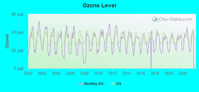
Ozone [ppb] level in 2022 was 32.4. This is about average. Closest monitor was 12.8 miles away from the city center.
| City: | 32.4 |
| U.S.: | 33.3 |
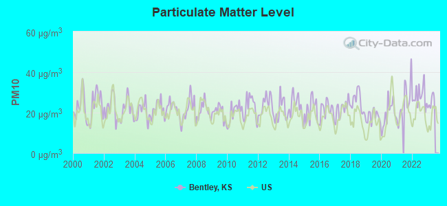
Particulate Matter (PM10) [µg/m3] level in 2022 was 28.1. This is significantly worse than average. Closest monitor was 14.5 miles away from the city center.
| City: | 28.1 |
| U.S.: | 19.2 |
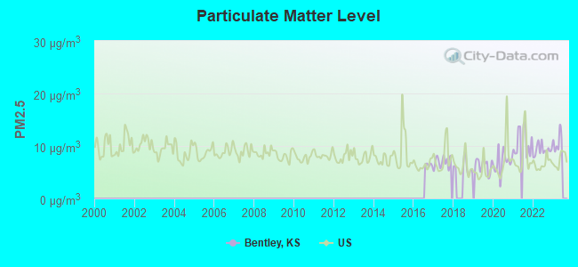
Particulate Matter (PM2.5) [µg/m3] level in 2022 was 9.24. This is about average. Closest monitor was 16.9 miles away from the city center.
| City: | 9.24 |
| U.S.: | 8.11 |
Tornado activity:
Bentley-area historical tornado activity is near Kansas state average. It is 103% greater than the overall U.S. average.
On 3/13/1990, a category F5 (max. wind speeds 261-318 mph) tornado 18.8 miles away from the Bentley city center killed one person and caused between $5,000,000 and $50,000,000 in damages.
On 3/13/1990, a category F5 tornado 21.8 miles away from the city center killed one person and injured 60 people and caused between $5,000,000 and $50,000,000 in damages.
Earthquake activity:
Bentley-area historical earthquake activity is significantly above Kansas state average. It is 798% greater than the overall U.S. average.On 9/3/2016 at 12:02:44, a magnitude 5.8 (5.8 MW, Depth: 3.5 mi, Class: Moderate, Intensity: VI - VII) earthquake occurred 106.1 miles away from Bentley center
On 11/6/2011 at 03:53:10, a magnitude 5.7 (5.7 MW, Depth: 3.2 mi) earthquake occurred 168.1 miles away from Bentley center
On 11/12/2014 at 21:40:00, a magnitude 4.9 (4.9 MW, Depth: 2.5 mi, Class: Light, Intensity: IV - V) earthquake occurred 42.9 miles away from the city center
On 2/13/2016 at 17:07:06, a magnitude 5.1 (5.1 MW, Depth: 5.2 mi) earthquake occurred 116.8 miles away from the city center
On 1/19/2020 at 19:08:42, a magnitude 4.5 (4.5 MW, Depth: 3.1 mi) earthquake occurred 26.6 miles away from the city center
On 11/7/2016 at 01:44:24, a magnitude 5.0 (5.0 MW, Depth: 2.8 mi) earthquake occurred 136.9 miles away from the city center
Magnitude types: moment magnitude (MW)
Natural disasters:
The number of natural disasters in Sedgwick County (16) is near the US average (15).Major Disasters (Presidential) Declared: 12
Emergencies Declared: 3
Causes of natural disasters: Floods: 8, Storms: 8, Tornadoes: 3, Winter Storms: 3, Explosion: 1, Heavy Rain: 1, Hurricane: 1, Ice Storm: 1, Wind: 1, Other: 1 (Note: some incidents may be assigned to more than one category).

Hospitals and medical centers near Bentley:
- SEDGWICK HEALTHCARE CENTER (Nursing Home, about 6 miles away; SEDGWICK, KS)
- COLWICH HEALTH CENTER (Nursing Home, about 8 miles away; COLWICH, KS)
- HALSTEAD HEALTH AND REHABILITATION CENTER (Nursing Home, about 8 miles away; HALSTEAD, KS)
- REGENCY HEALTH CARE CENTER (Nursing Home, about 8 miles away; HALSTEAD, KS)
- MOUNT HOPE NURSING CENTER (Nursing Home, about 8 miles away; MOUNT HOPE, KS)
- HEARTLAND HOME HEALTH (Home Health Center, about 9 miles away; HALSTEAD, KS)
- HERTZLER REGIONAL MEDICAL CENTER (Hospital, about 9 miles away; HALSTEAD, KS)
Airports located in Bentley:
- Eagle Field Airport (7KS9) (Runways: 1)
- Roberts Field Airport (SN62) (Runways: 1)
Colleges/universities with over 2000 students nearest to Bentley:
- Friends University (about 17 miles; Wichita, KS; Full-time enrollment: 2,024)
- Newman University (about 17 miles; Wichita, KS; FT enrollment: 2,066)
- Wichita State University (about 17 miles; Wichita, KS; FT enrollment: 11,743)
- Wichita Technical Institute (about 18 miles; Wichita, KS; FT enrollment: 2,015)
- Wichita Area Technical College (about 19 miles; Wichita, KS; FT enrollment: 2,220)
- Hutchinson Community College (about 26 miles; Hutchinson, KS; FT enrollment: 4,174)
- Butler Community College (about 36 miles; El Dorado, KS; FT enrollment: 6,676)
Public elementary/middle school in Bentley:
- BENTLEY PRIMARY SCHOOL (Students: 229, Location: 221 N PHELPS, Grades: PK-3)
Points of interest:
Notable locations in Bentley: Bentley Police Department (A), Bentley City Hall (B), Bentley Fire and Emergency Management Services (C). Display/hide their locations on the map
Church in Bentley: Bentley United Methodist Church (A). Display/hide its location on the map
Drinking water stations with addresses in Bentley that have no violations reported:
- BENTLEY, CITY OF (Population served: 528, Primary Water Source Type: Purch groundwater)
| This city: | 2.7 people |
| Kansas: | 2.5 people |
| This city: | 71.4% |
| Whole state: | 66.0% |
| This city: | 7.0% |
| Whole state: | 5.8% |
Likely homosexual households (counted as self-reported same-sex unmarried-partner households)
- Lesbian couples: 0.5% of all households
- Gay men: 0.0% of all households
Banks with branches in Bentley (2011 data):
- The Halstead Bank: At Bentley at 101 North Wichita, branch established on 1901/06/06. Info updated 2009/04/03: Bank assets: $76.5 mil, Deposits: $67.3 mil, headquarters in Halstead, KS, positive income, Agricultural Specialization, 5 total offices, Holding Company: Williams Holding Company, Inc.
For population 15 years and over in Bentley:
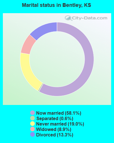
- Never married: 19.0%
- Now married: 58.1%
- Separated: 0.6%
- Widowed: 8.9%
- Divorced: 13.3%
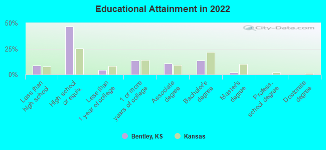
For population 25 years and over in Bentley:
- High school or higher: 89.0%
- Bachelor's degree or higher: 14.5%
- Graduate or professional degree: 1.9%
- Unemployed: 0.5%
- Mean travel time to work (commute): 27.5 minutes
| Here: | 8.5 |
| Kansas average: | 11.5 |
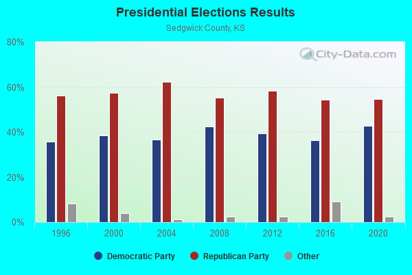
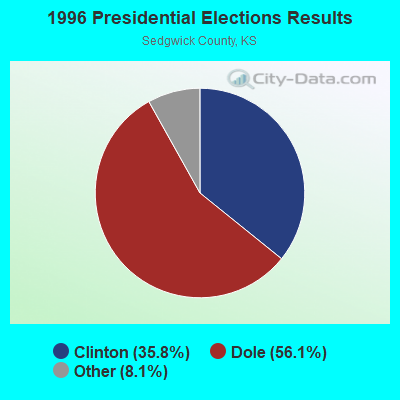
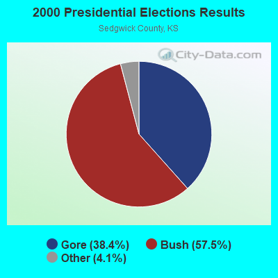
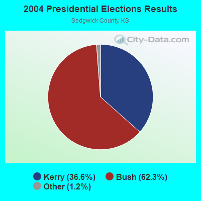
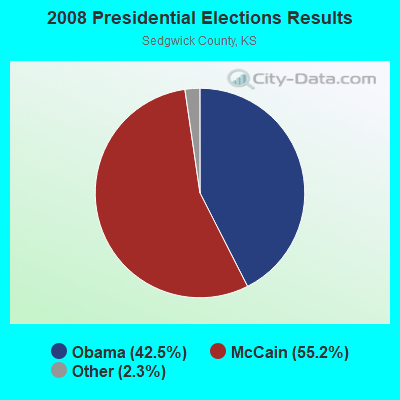
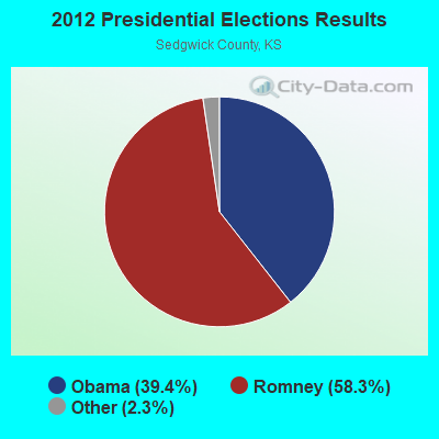
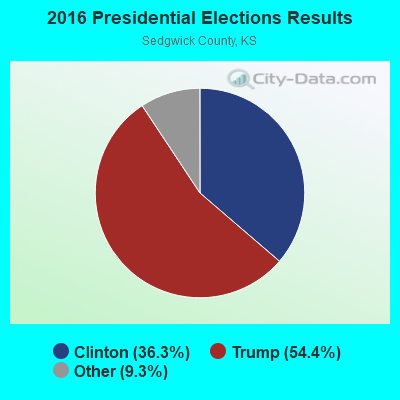

Graphs represent county-level data. Detailed 2008 Election Results
Religion statistics for Bentley, KS (based on Sedgwick County data)
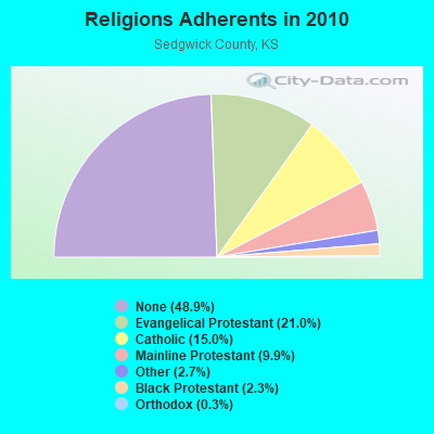
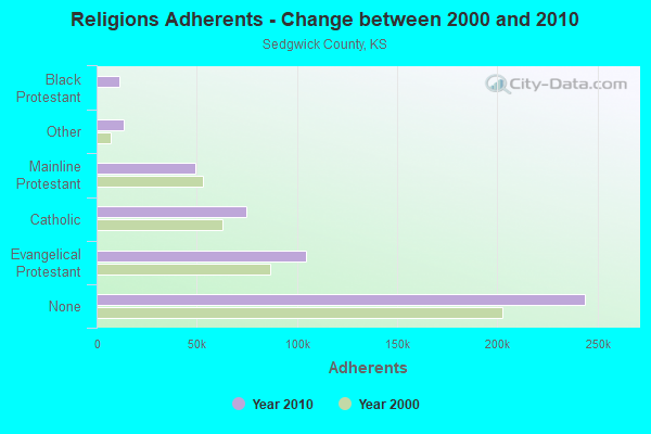
| Religion | Adherents | Congregations |
|---|---|---|
| Evangelical Protestant | 104,418 | 317 |
| Catholic | 74,600 | 32 |
| Mainline Protestant | 49,200 | 118 |
| Other | 13,532 | 47 |
| Black Protestant | 11,312 | 28 |
| Orthodox | 1,361 | 4 |
| None | 243,942 | - |
Food Environment Statistics:
| This county: | 1.33 / 10,000 pop. |
| Kansas: | 1.96 / 10,000 pop. |
| Here: | 0.13 / 10,000 pop. |
| State: | 0.20 / 10,000 pop. |
| This county: | 0.34 / 10,000 pop. |
| Kansas: | 0.51 / 10,000 pop. |
| Here: | 2.38 / 10,000 pop. |
| State: | 3.84 / 10,000 pop. |
| This county: | 6.44 / 10,000 pop. |
| Kansas: | 7.33 / 10,000 pop. |
| This county: | 8.7% |
| Kansas: | 8.1% |
| Here: | 28.3% |
| State: | 27.9% |
| Here: | 16.5% |
| Kansas: | 13.4% |
Health and Nutrition:
| Here: | 50.7% |
| Kansas: | 49.2% |
| Bentley: | 48.8% |
| Kansas: | 46.3% |
| Bentley: | 28.7 |
| Kansas: | 28.6 |
| Bentley: | 20.9% |
| Kansas: | 21.2% |
| Bentley: | 9.7% |
| Kansas: | 10.5% |
| This city: | 6.8 |
| Kansas: | 6.8 |
| Bentley: | 33.7% |
| State: | 33.5% |
| Bentley: | 58.8% |
| State: | 56.0% |
| This city: | 79.2% |
| Kansas: | 78.6% |
More about Health and Nutrition of Bentley, KS Residents
| Local government employment and payroll (March 2022) | |||||
| Function | Full-time employees | Monthly full-time payroll | Average yearly full-time wage | Part-time employees | Monthly part-time payroll |
|---|---|---|---|---|---|
| Financial Administration | 2 | $4,828 | $28,968 | 0 | $0 |
| Streets and Highways | 1 | $2,996 | $35,952 | 0 | $0 |
| Police Protection - Officers | 0 | $0 | 1 | $737 | |
| Firefighters | 0 | $0 | 7 | $1,473 | |
| Other Government Administration | 0 | $0 | 7 | $842 | |
| Totals for Government | 3 | $7,824 | $31,296 | 15 | $3,052 |
Bentley government finances - Expenditure in 2017 (per resident):
- Construction - General - Other: $11,000 ($19.47)
- Current Operations - Financial Administration: $199,000 ($352.21)
Water Utilities: $74,000 ($130.97)
Solid Waste Management: $39,000 ($69.03)
Sewerage: $32,000 ($56.64)
Police Protection: $28,000 ($49.56)
Regular Highways: $21,000 ($37.17)
Local Fire Protection: $17,000 ($30.09)
Judicial and Legal Services: $3,000 ($5.31)
- General - Interest on Debt: $61,000 ($107.96)
- Total Salaries and Wages: $122,000 ($215.93)
- Water Utilities - Interest on Debt: $14,000 ($24.78)
Bentley government finances - Revenue in 2017 (per resident):
- Charges - Sewerage: $44,000 ($77.88)
Solid Waste Management: $38,000 ($67.26)
- Local Intergovernmental - General Local Government Support: $69,000 ($122.12)
- Miscellaneous - Special Assessments: $70,000 ($123.89)
Fines and Forfeits: $21,000 ($37.17)
General Revenue - Other: $21,000 ($37.17)
- Revenue - Water Utilities: $108,000 ($191.15)
- State Intergovernmental - Highways: $11,000 ($19.47)
General Local Government Support: $7,000 ($12.39)
- Tax - Property: $390,000 ($690.27)
Public Utilities Sales: $18,000 ($31.86)
Other License: $17,000 ($30.09)
Bentley government finances - Debt in 2017 (per resident):
- Long Term Debt - Beginning Outstanding - Unspecified Public Purpose: $1,824,000 ($3228.32)
Outstanding Unspecified Public Purpose: $1,727,000 ($3056.64)
Retired Unspecified Public Purpose: $97,000 ($171.68)
Bentley government finances - Cash and Securities in 2017 (per resident):
- Bond Funds - Cash and Securities: $5,000 ($8.85)
- Other Funds - Cash and Securities: $420,000 ($743.36)
- Sinking Funds - Cash and Securities: $13,000 ($23.01)
4.59% of this county's 2021 resident taxpayers lived in other counties in 2020 ($63,222 average adjusted gross income)
| Here: | 4.59% |
| Kansas average: | 6.64% |
0.03% of residents moved from foreign countries ($380 average AGI)
Sedgwick County: 0.03% Kansas average: 0.04%
Top counties from which taxpayers relocated into this county between 2020 and 2021:
| from Butler County, KS | |
| from Reno County, KS | |
| from Harvey County, KS |
4.79% of this county's 2020 resident taxpayers moved to other counties in 2021 ($59,492 average adjusted gross income)
| Here: | 4.79% |
| Kansas average: | 6.88% |
0.03% of residents moved to foreign countries ($328 average AGI)
Sedgwick County: 0.03% Kansas average: 0.03%
Top counties to which taxpayers relocated from this county between 2020 and 2021:
| to Butler County, KS | |
| to Johnson County, KS | |
| to Sumner County, KS |
Strongest AM radio stations in Bentley:
- KFTI (1070 AM; 10 kW; WICHITA, KS; Owner: JOURNAL BROADCAST CORPORATION)
- KMYR (1410 AM; 5 kW; WICHITA, KS; Owner: AGAPE COMMUNICATIONS, INC.)
- KQAM (1480 AM; 5 kW; WICHITA, KS; Owner: ABC, INC.)
- KFH (1330 AM; 5 kW; WICHITA, KS; Owner: ENTERCOM WICHITA LICENSE, LLC)
- KRMG (740 AM; 50 kW; TULSA, OK; Owner: CXR HOLDINGS, INC.)
- KJRG (950 AM; 0 kW; NEWTON, KS)
- KNSS (1240 AM; 1 kW; WICHITA, KS; Owner: ENTERCOM WICHITA LICENSE, LLC)
- KFAQ (1170 AM; 50 kW; TULSA, OK; Owner: JOURNAL BROADCAST CORPORATION)
- WHB (810 AM; 50 kW; KANSAS CITY, MO; Owner: UNION BROADCASTING, INC.)
- KRVN (880 AM; 50 kW; LEXINGTON, NE; Owner: NEBRASKA RURAL RADIO ASSOCIATION)
- KSGL (900 AM; 0 kW; WICHITA, KS; Owner: AGAPE COMMUNICATIONS, INC.)
- KOMA (1520 AM; 50 kW; OKLAHOMA CITY, OK; Owner: RENDA BROADCASTING CORP. OF NEVADA)
- KWBW (1450 AM; 1 kW; HUTCHINSON, KS; Owner: EAGLE RADIO, INC.)
Strongest FM radio stations in Bentley:
- KFDI-FM (101.3 FM; WICHITA, KS; Owner: JOURNAL BROADCAST CORPORATION)
- KZSN (102.1 FM; HUTCHINSON, KS; Owner: CAPSTAR TX LIMITED PARTNERSHIP)
- KICT-FM (95.1 FM; WICHITA, KS; Owner: JOURNAL BROADCAST CORPORATION)
- KRBB (97.9 FM; WICHITA, KS; Owner: CAPSTAR TX LIMITED PARTNERSHIP)
- KFBZ (105.3 FM; HAYSVILLE, KS; Owner: ENTERCOM WICHITA LICENSE, LLC)
- KKRD (107.3 FM; WICHITA, KS; Owner: CAPSTAR TX LIMITED PARTNERSHIP)
- KEYN-FM (103.7 FM; WICHITA, KS; Owner: ENTERCOM WICHITA LICENSE, LLC)
- KHCC-FM (90.1 FM; HUTCHINSON, KS; Owner: HUTCHINSON COMMUNITY JR. COLLEGE)
- KMXW (92.3 FM; NEWTON, KS; Owner: JOURNAL BROADCAST CORPORATION)
- KCFN (91.1 FM; WICHITA, KS; Owner: AMERICAN FAMILY ASSOCIATION)
- KRZZ-FM (96.3 FM; DERBY, KS; Owner: CAPSTAR TX LIMITED PARTNERSHIP)
- KMUW (89.1 FM; WICHITA, KS; Owner: WICHITA STATE UNIVERSITY)
- KYQQ (106.5 FM; ARKANSAS CITY, KS; Owner: JOURNAL BROADCAST CORPORATION)
- KCVW (94.3 FM; KINGMAN, KS; Owner: COMMUNITY BROADCASTING, INC.)
- KSKU (97.1 FM; HUTCHINSON, KS; Owner: AD ASTRA PER ASPERA BROADCASTING, IN)
- KHMY (93.1 FM; PRATT, KS; Owner: EAGLE RADIO, INC.)
- KTLI (99.1 FM; EL DORADO, KS; Owner: ADONAI RADIO GROUP, INC.)
- KXKU (106.1 FM; LYONS, KS; Owner: AD ASTRA PER ASPERA B/CING, INC.)
- KANR (92.7 FM; BELLE PLAINE, KS; Owner: DANIEL D. SMITH)
- KDGS (93.9 FM; ANDOVER, KS; Owner: ENTERCOM WICHITA LICENSE, LLC)
TV broadcast stations around Bentley:
- KSCC (Channel 36; HUTCHINSON, KS; Owner: MERCURY BROADCASTING COMPANY, INC.)
- KWCV (Channel 33; WICHITA, KS; Owner: WLBB BROADCASTING, L.L.C.)
- KSNW (Channel 3; WICHITA, KS; Owner: EMMIS TELEVISION LICENSE CORPORATION OF WICHITA)
- KSAS-TV (Channel 24; WICHITA, KS; Owner: CLEAR CHANNEL BROADCASTING LICENSES, INC.)
- KAKE-TV (Channel 10; WICHITA, KS; Owner: GRAY MIDAMERICA TV LICENSEE CORP.)
- KCTU-LP (Channel 55; WICHITA, KS; Owner: RIVER CITY BROADCASTING CORP.)
- KSMI-LP (Channel 51; WICHITA, KS; Owner: RIVER CITY BROADCASTING CORP.)
- KWCH-TV (Channel 12; HUTCHINSON, KS; Owner: MEDIA GENERAL BROADCASTING OF SO. CAROLINA HOLDINGS, INC.)
- KPTS (Channel 8; HUTCHINSON, KS; Owner: KANSAS PUBLIC TELECOMMUNICATIONS SERVICE, INC.)
- KTQW-LP (Channel 53; WICHITA, KS; Owner: KNOWLEDGE L.C.)
- KFVT-LP (Channel 40; WICHITA, KS; Owner: LOCKE SUPPLY CO.)
- K59DA (Channel 59; WICHITA, KS; Owner: TRINITY BROADCASTING NETWORK)
- K15DD (Channel 15; WICHITA, KS; Owner: VENTANA TELEVISION, INC.)
Bentley fatal accident list:
- National Bridge Inventory (NBI) Statistics
- 16Number of bridges
- 177ft / 54.3mTotal length
- $1,750,000Total costs
- 5,802Total average daily traffic
- 237Total average daily truck traffic
- 7,305Total future (year 2038) average daily traffic
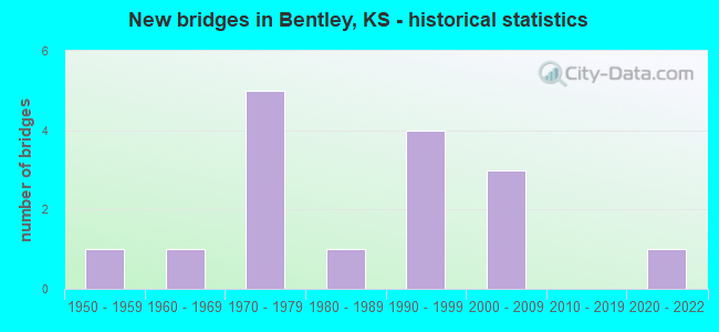
- New bridges - historical statistics
- 11950-1959
- 11960-1969
- 51970-1979
- 11980-1989
- 41990-1999
- 32000-2009
- 12020-2022
FCC Registered Antenna Towers:
3- Amanda V Fry, 109th St. & Raymond Drive (Lat: 37.884000 Lon: -97.508889), Type: 64.0, Structure height: 20173 m, Overall height: 61 m, Registrant: Towerco 2013 LLC, Afry@towerco.Com, Suite 200, Cary, Phone: (919) 653-5710
- Amanda V Fry, 109th St. & Raymond Drive (Lat: 37.884000 Lon: -97.508889), Type: 64.0, Structure height: 20173 m, Overall height: 61 m, Registrant: Towerco 2013 LLC, Afry@towerco.Com, Suite 200, Cary, Phone: (919) 653-5710
- Amanda V Fry, 109th St. & Raymond Drive (Lat: 37.884000 Lon: -97.508889), Type: 64.0, Structure height: 20173 m, Overall height: 61 m, Registrant: Towerco 2013 LLC, Afry@towerco.Com, Suite 200, Cary, Phone: (919) 653-5710
FCC Registered Broadcast Land Mobile Towers:
1- Lat: 37.885611 Lon: -97.516306, Call Sign: WQNC399,
Assigned Frequencies: 460.537 MHz, 465.537 MHz, Grant Date: 09/15/2020, Expiration Date: 12/13/2030, Certifier: Dan G Bliss, Registrant: Business Radio Licensing, 30251 Golden Lantern, Suite E # 501, Laguna Niguel, CA 92677, Phone: (949) 348-8510, Fax: (949) 348-8514, Email:
FCC Registered Microwave Towers:
1- KSBENTLEYNO1, W 117th St & N 151st St W (Lat: 37.894389 Lon: -97.512250), Type: Ltower, Structure height: 24.4 m, Call Sign: WRKD443, Licensee ID: L01704672,
Assigned Frequencies: 11245.0 MHz, 11245.0 MHz, 11245.0 MHz, 11245.0 MHz, 11245.0 MHz, 11245.0 MHz, 11245.0 MHz, 11245.0 MHz, 11245.0 MHz, 11245.0 MHz... (+10 more), Grant Date: 12/15/2020, Expiration Date: 12/15/2030, Cancellation Date: 07/12/2021, Certifier: Jack Marsh, Registrant: Amg Technology Investment Group, 95 Parker Oaks Lane, Hudson Oaks, TX 76087, Phone: (855) 698-5465, Email:
FCC Registered Amateur Radio Licenses:
2- Call Sign: N0ZGU, Grant Date: 11/09/1993, Expiration Date: 11/09/2003, Cancellation Date: 11/10/2005, Registrant: Dorris D Dunnavent, 227 Raymond Dr, Bentley, KS 67016
- Call Sign: W0OI, Grant Date: 01/24/1996, Expiration Date: 01/24/2006, Cancellation Date: 01/25/2008, Registrant: William F Brown, 320 N Phelps, Bentley, KS 67016
2002 - 2018 National Fire Incident Reporting System (NFIRS) incidents
- Fire incident types reported to NFIRS in Bentley, KS
- 7469.2%Outside Fires
- 2220.6%Structure Fires
- 1110.3%Mobile Property/Vehicle Fires
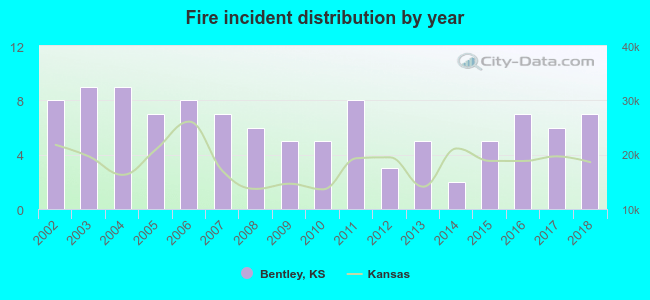 Based on the data from the years 2002 - 2018 the average number of fire incidents per year is 6. The highest number of reported fire incidents - 9 took place in 2003, and the least - 2 in 2014. The data has a declining trend.
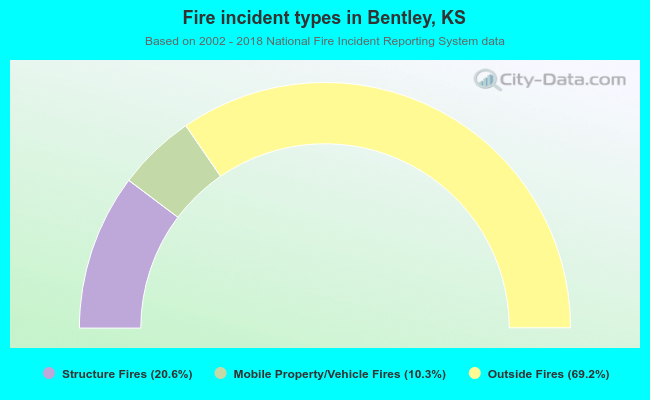 When looking into fire subcategories, the most incidents belonged to: Outside Fires (69.2%), and Structure Fires (20.6%).
| Most common first names in Bentley, KS among deceased individuals | ||
| Name | Count | Lived (average) |
|---|---|---|
| John | 6 | 72.2 years |
| James | 5 | 78.2 years |
| William | 5 | 77.6 years |
| Charles | 4 | 74.8 years |
| Joseph | 3 | 77.7 years |
| Wilma | 3 | 77.0 years |
| Clara | 2 | 78.5 years |
| Gerald | 2 | 60.5 years |
| Daisy | 2 | 84.5 years |
| Gladys | 2 | 85.9 years |
| Most common last names in Bentley, KS among deceased individuals | ||
| Last name | Count | Lived (average) |
|---|---|---|
| Cutting | 5 | 73.2 years |
| Adams | 4 | 73.7 years |
| Rosenberger | 4 | 83.0 years |
| Wilson | 4 | 58.8 years |
| Johnson | 3 | 74.6 years |
| Basore | 3 | 74.7 years |
| Fowler | 3 | 74.0 years |
| Boyd | 3 | 64.1 years |
| Pitts | 3 | 87.6 years |
| Smith | 3 | 85.7 years |
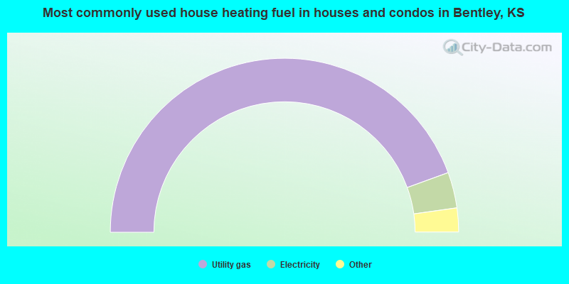
- 89.6%Utility gas
- 6.7%Electricity
- 1.5%Bottled, tank, or LP gas
- 1.5%Other fuel
- 0.7%Wood
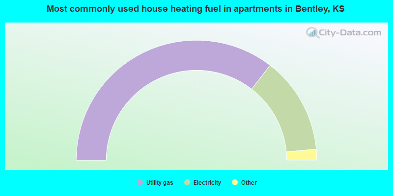
- 73.1%Utility gas
- 26.9%Electricity
Bentley compared to Kansas state average:
- Median house value below state average.
- Unemployed percentage significantly below state average.
- Black race population percentage significantly below state average.
- Foreign-born population percentage above state average.
- Renting percentage significantly below state average.
- Length of stay since moving in above state average.
- Number of college students below state average.
- Percentage of population with a bachelor's degree or higher below state average.
Bentley on our top lists:
- #82 on the list of "Top 100 safest cities (lowest city-data.com crime index)"
- #28 on the list of "Top 101 counties with the highest carbon monoxide air pollution readings in 2012 (ppm)"
- #44 on the list of "Top 101 counties with the highest number of infant deaths per 1000 residents 2007-2013 (pop. 50,000+)"
- #45 on the list of "Top 101 counties with the highest number of births per 1000 residents 2007-2013"
- #55 on the list of "Top 101 counties with the highest Particulate Matter (PM10) Annual air pollution readings in 2012 (µg/m3)"
- #57 on the list of "Top 101 counties with the highest Nitrogen Dioxide air pollution readings in 2012 (ppm)"