Bethel Heights, Arkansas
Submit your own pictures of this town and show them to the world
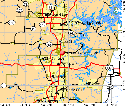
- OSM Map
- General Map
- Google Map
- MSN Map
Population change since 2000: +316.0%
| Males: 1,598 | |
| Females: 1,372 |
| Median resident age: | 29.0 years |
| Arkansas median age: | 38.9 years |
| Bethel Heights: | $103,981 |
| AR: | $55,432 |
Estimated per capita income in 2022: $42,238 (it was $19,001 in 2000)
Bethel Heights town income, earnings, and wages data
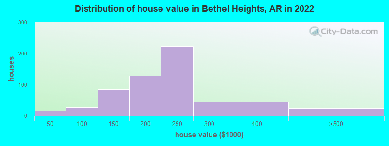
Estimated median house or condo value in 2022: $426,489 (it was $129,100 in 2000)
| Bethel Heights: | $426,489 |
| AR: | $179,800 |
Mean prices in 2022: all housing units: $239,704; detached houses: $238,918
Median gross rent in 2022: $1,244.
Bethel Heights, AR residents, houses, and apartments details
(11.6% for White Non-Hispanic residents, 14.9% for Black residents, 14.0% for Hispanic or Latino residents, 19.6% for Native Hawaiian and other Pacific Islander residents, 6.4% for other race residents, 20.8% for two or more races residents)
Detailed information about poverty and poor residents in Bethel Heights, AR
Compare current foreclosures near Bethel Heights, AR:
| Photo | Address | Area | Beds / Baths | Price | Details |
|---|---|---|---|---|---|

|
#1
Bernice Ave
Springdale, AR 72762
|
1,944 sq. feet
|
2 baths 3 beds |
show details | |

|
#2
Topaz St
Lowell, AR 72745
|
1,474 sq. feet
|
2 baths 3 beds |
show details | |

|
#3
Excalibur Dr
Springdale, AR 72762
|
3,659 sq. feet
|
3 baths 5 beds |
show details | |

|
#4
Cypress Ln
Rogers, AR 72756
|
1,056 sq. feet
|
1 baths 2 beds |
show details | |

|
#5
Old Charley Rd
Gravette, AR 72736
|
3,129 sq. feet
|
3 baths 5 beds |
show details | |

|
#6
Shoffner Ln
Elkins, AR 72727
|
1,891 sq. feet
|
2 baths 4 beds |
show details | |

|
#7
Timber Ridge St
Centerton, AR 72719
|
- sq. feet
|
2 baths 3 beds |
show details | |

|
#8
Ellen St
Springdale, AR 72762
|
1,753 sq. feet
|
2 baths 3 beds |
show details | |

|
#9
Dassero Ct
Centerton, AR 72719
|
1,547 sq. feet
|
2 baths 3 beds |
show details | |

|
#10
Cloverdale Rd
Rogers, AR 72756
|
988 sq. feet
|
1 baths 2 beds |
show details |
| Photo | Address | Area | Beds / Baths | Price | Details |
|---|---|---|---|---|---|

|
#11
Forest Drive
Centerton, AR 72719
|
1,526 sq. feet
|
2 baths 3 beds |
show details | |

|
#12
Washburn Dr
Pea Ridge, AR 72751
|
- sq. feet
|
2 baths 3 beds |
show details | |

|
#13
Haywood Cv
Springdale, AR 72764
|
1,847 sq. feet
|
2 baths 3 beds |
show details | |

|
#14
Richland Creek Ave
Elkins, AR 72727
|
1,286 sq. feet
|
2 baths 3 beds |
show details | |

|
#15
Frisco Track Trce
Elkins, AR 72727
|
1,367 sq. feet
|
2 baths 3 beds |
show details | |

|
#16
S Ed Edwards Rd
Fayetteville, AR 72701
|
1,902 sq. feet
|
2 baths 3 beds |
show details | |

|
#17
W Shale St
Fayetteville, AR 72704
|
1,308 sq. feet
|
2 baths - beds |
show details | |

|
#18
N Boxley Ave
Fayetteville, AR 72704
|
1,370 sq. feet
|
2 baths 3 beds |
show details | |

|
#19
E Lawndale Dr
Fayetteville, AR 72701
|
1,306 sq. feet
|
2 baths 3 beds |
show details | |

|
#20
N Old Wire Rd
Rogers, AR 72756
|
4,170 sq. feet
|
2 baths - beds |
show details |
| Photo | Address | Area | Beds / Baths | Price | Details |
|---|---|---|---|---|---|

|
#21
Remington St
Springdale, AR 72764
|
1,309 sq. feet
|
2 baths 3 beds |
show details | |

|
#22
Woodside Ln
Rogers, AR 72756
|
2,918 sq. feet
|
2 baths - beds |
show details | |

|
#23
N John Wayne Dr
Fayetteville, AR 72703
|
1,720 sq. feet
|
2 baths - beds |
show details | |

|
#24
E Oakcliff St
Fayetteville, AR 72703
|
2,134 sq. feet
|
2 baths - beds |
show details | |

|
#25
E Cydnee St
Fayetteville, AR 72703
|
1,702 sq. feet
|
2 baths - beds |
show details | |

|
#26
W Oak St
Rogers, AR 72758
|
2,001 sq. feet
|
2 baths - beds |
show details | |

|
#27
Sun Meadow Dr
Centerton, AR 72719
|
1,248 sq. feet
|
2 baths - beds |
show details | |

|
#28
S 15th St
Rogers, AR 72758
|
1,585 sq. feet
|
2 baths - beds |
show details | |

|
#29
Sheffield Rd
Siloam Springs, AR 72761
|
3,276 sq. feet
|
3 baths - beds |
show details | |

|
#30
S J St
Rogers, AR 72756
|
2,044 sq. feet
|
3 baths - beds |
show details |
| Photo | Address | Area | Beds / Baths | Price | Details |
|---|---|---|---|---|---|

|
#31
N Lancaster Ln
Fayetteville, AR 72703
|
1,876 sq. feet
|
2 baths - beds |
show details | |

|
#32
Keenan Ave
Springdale, AR 72764
|
1,999 sq. feet
|
2 baths - beds |
show details | |

|
#33
Paw Paw Ln
Fayetteville, AR 72704
|
1,788 sq. feet
|
1 baths - beds |
show details | |

|
#34
W Olive St
Rogers, AR 72756
|
820 sq. feet
|
1 baths - beds |
show details | |

|
#35
Douglas Cir
Rogers, AR 72756
|
988 sq. feet
|
2 baths - beds |
show details | |

|
#36
N Sassafras Hill Rd
Fayetteville, AR 72703
|
1,840 sq. feet
|
2 baths - beds |
show details | |

|
#37
Harvest St
Centerton, AR 72719
|
1,770 sq. feet
|
2 baths - beds |
show details | |

|
#38
Lakeview Dr
Rogers, AR 72756
|
2,420 sq. feet
|
2 baths - beds |
show details | |

|
#39
Donington Ln
Bella Vista, AR 72714
|
1,024 sq. feet
|
2 baths - beds |
show details | |

|
#40
Cynthia Ave
Farmington, AR 72730
|
1,488 sq. feet
|
1 baths - beds |
show details |
| Photo | Address | Area | Beds / Baths | Price | Details |
|---|---|---|---|---|---|

|
#41
Winters St
Pea Ridge, AR 72751
|
2,847 sq. feet
|
2 baths - beds |
show details | |

|
#42
S D St
Rogers, AR 72756
|
1,463 sq. feet
|
2 baths - beds |
show details | |

|
#43
S Maestri Rd
Springdale, AR 72762
|
1,820 sq. feet
|
1 baths - beds |
show details | |

|
#44
S Hunter St
Farmington, AR 72730
|
1,344 sq. feet
|
2 baths - beds |
show details | |

|
#45
W Lela St
Rogers, AR 72758
|
1,728 sq. feet
|
2 baths - beds |
show details | |

|
#46
Hawkins St
Farmington, AR 72730
|
1,661 sq. feet
|
2 baths - beds |
show details | |

|
#47
W Lela St
Rogers, AR 72758
|
1,693 sq. feet
|
2 baths - beds |
show details | |

|
#48
Wolfdale Rd
Farmington, AR 72730
|
1,878 sq. feet
|
2 baths - beds |
show details | |

|
#49
S 15th St
Rogers, AR 72758
|
1,575 sq. feet
|
2 baths - beds |
show details | |

|
Check over 1 million property listings on Foreclosure.com!
|
browse all offers | |||


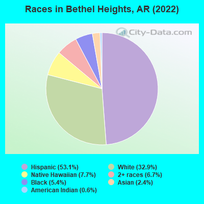
- 1,48053.1%Hispanic
- 91732.9%White alone
- 2157.7%Native Hawaiian and Other
Pacific Islander alone - 1876.7%Two or more races
- 1515.4%Black alone
- 662.4%Asian alone
- 180.6%American Indian alone
According to our research of Arkansas and other state lists, there was 1 registered sex offender living in Bethel Heights, Arkansas as of May 17, 2024.
The ratio of all residents to sex offenders in Bethel Heights is 2,622 to 1.
The ratio of registered sex offenders to all residents in this city is much lower than the state average.
 Recent articles from our blog. Our writers, many of them Ph.D. graduates or candidates, create easy-to-read articles on a wide variety of topics.

 | Would Merging The Four NWA Cities Stop The Fighting?? (37 replies) |
| Let's talk Trash... (22 replies) |
| NWA Population (47 replies) |
| Okay, how about Northwest Arkansas?? (28 replies) |
| Wanting to relocate to NW Arkansas (25 replies) |
Latest news from Bethel Heights, AR collected exclusively by city-data.com from local newspapers, TV, and radio stations
Ancestries: American (4.5%), English (2.0%), European (1.4%), Irish (1.4%).
Current Local Time: CST time zone
Elevation: 1344 feet
Land area: 2.52 square miles.
Population density: 1,176 people per square mile (low).
746 residents are foreign born (22.2% Latin America, 4.6% Oceania).
| This town: | 26.7% |
| Arkansas: | 100.0% |
Median real estate property taxes paid for housing units with mortgages in 2022: $1,327 (0.5%)
Median real estate property taxes paid for housing units with no mortgage in 2022: $1,819 (0.6%)
Nearest city with pop. 50,000+: Fayetteville, AR  (10.3 miles , pop. 58,047).
Nearest city with pop. 200,000+: Tulsa, OK (101.2 miles , pop. 393,049).
Nearest city with pop. 1,000,000+: Dallas, TX (281.1 miles , pop. 1,188,580).
Nearest cities:
), ), ), ), )Latitude: 36.22 N, Longitude: 94.13 W
Area code commonly used in this area: 479
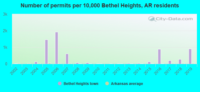
Single-family new house construction building permits:
- 2019: 65 buildings, average cost: $207,200
- 2018: 20 buildings, average cost: $213,200
- 2017: 14 buildings, average cost: $151,500
- 2016: 63 buildings, average cost: $111,000
- 2015: 9 buildings, average cost: $172,600
- 2014: 2 buildings, average cost: $100,000
- 2013: 2 buildings, average cost: $72,200
- 2012: 1 building, cost: $67,000
- 2010: 1 building, cost: $54,700
- 2009: 5 buildings, average cost: $74,700
- 2008: 5 buildings, average cost: $90,400
- 2007: 44 buildings, average cost: $61,000
- 2006: 137 buildings, average cost: $97,300
- 2005: 105 buildings, average cost: $100,600
- 2004: 9 buildings, average cost: $157,500
- 2002: 1 building, cost: $175,000

| Here: | 2.5% |
| Arkansas: | 3.4% |
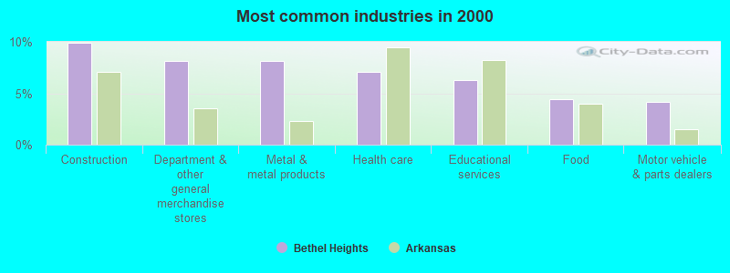
- Construction (9.9%)
- Department & other general merchandise stores (8.1%)
- Metal & metal products (8.1%)
- Health care (7.1%)
- Educational services (6.3%)
- Food (4.5%)
- Motor vehicle & parts dealers (4.2%)
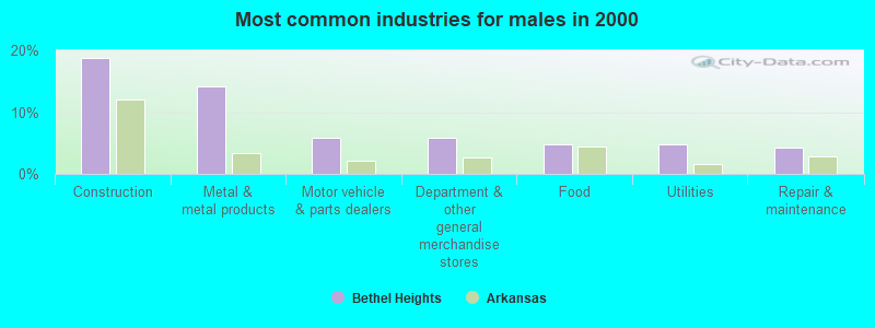
- Construction (18.8%)
- Metal & metal products (14.1%)
- Motor vehicle & parts dealers (5.8%)
- Department & other general merchandise stores (5.8%)
- Food (4.7%)
- Utilities (4.7%)
- Repair & maintenance (4.2%)
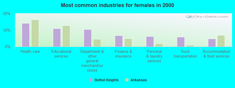
- Health care (14.1%)
- Educational services (11.0%)
- Department & other general merchandise stores (10.5%)
- Finance & insurance (6.8%)
- Personal & laundry services (6.3%)
- Truck transportation (5.8%)
- Accommodation & food services (4.7%)
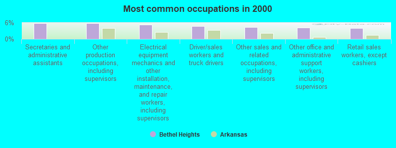
- Secretaries and administrative assistants (5.8%)
- Other production occupations, including supervisors (5.8%)
- Electrical equipment mechanics and other installation, maintenance, and repair workers, including supervisors (5.2%)
- Driver/sales workers and truck drivers (4.7%)
- Other sales and related occupations, including supervisors (4.5%)
- Other office and administrative support workers, including supervisors (4.2%)
- Retail sales workers, except cashiers (3.9%)
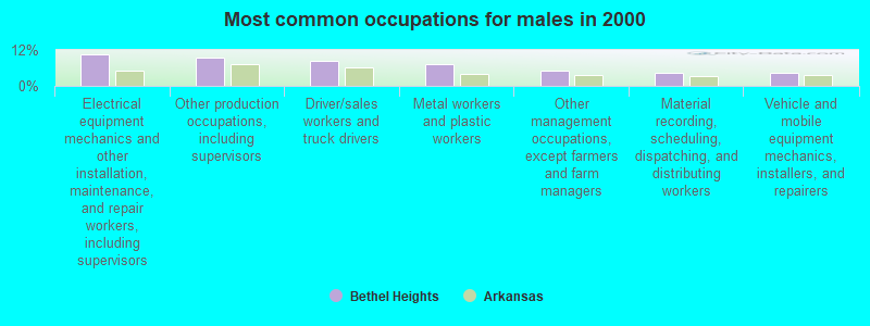
- Electrical equipment mechanics and other installation, maintenance, and repair workers, including supervisors (10.5%)
- Other production occupations, including supervisors (9.4%)
- Driver/sales workers and truck drivers (8.4%)
- Metal workers and plastic workers (7.3%)
- Other management occupations, except farmers and farm managers (5.2%)
- Material recording, scheduling, dispatching, and distributing workers (4.2%)
- Vehicle and mobile equipment mechanics, installers, and repairers (4.2%)
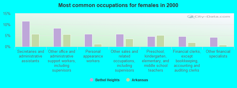
- Secretaries and administrative assistants (11.5%)
- Other office and administrative support workers, including supervisors (8.4%)
- Personal appearance workers (5.8%)
- Other sales and related occupations, including supervisors (5.8%)
- Preschool, kindergarten, elementary, and middle school teachers (4.7%)
- Financial clerks, except bookkeeping, accounting and auditing clerks (4.7%)
- Other financial specialists (4.2%)
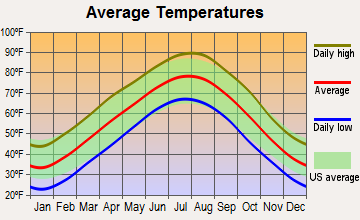
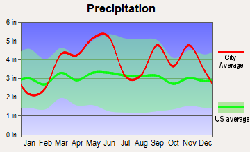
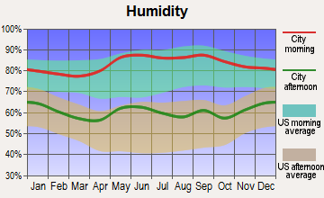
Average climate in Bethel Heights, Arkansas
Based on data reported by over 4,000 weather stations
(lower is better)
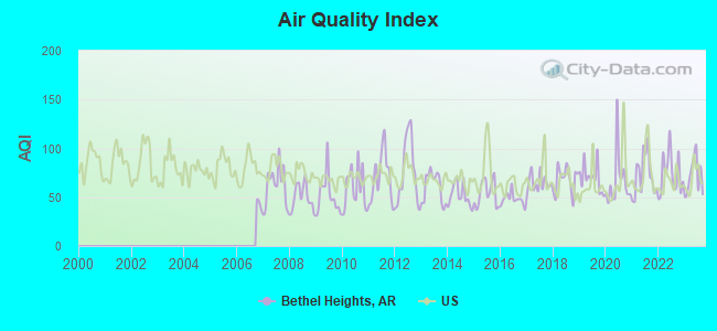
Air Quality Index (AQI) level in 2023 was 71.4. This is about average.
| City: | 71.4 |
| U.S.: | 72.6 |
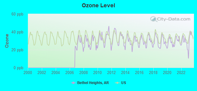
Ozone [ppb] level in 2023 was 32.9. This is about average. Closest monitor was 3.0 miles away from the city center.
| City: | 32.9 |
| U.S.: | 33.3 |
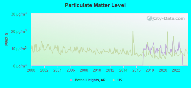
Particulate Matter (PM2.5) [µg/m3] level in 2022 was 8.95. This is about average. Closest monitor was 3.0 miles away from the city center.
| City: | 8.95 |
| U.S.: | 8.11 |
Tornado activity:
Bethel Heights-area historical tornado activity is near Arkansas state average. It is 86% greater than the overall U.S. average.
On 4/30/1954, a category F3 (max. wind speeds 158-206 mph) tornado 11.1 miles away from the Bethel Heights town center injured one person and caused between $50,000 and $500,000 in damages.
On 3/24/1954, a category F3 tornado 12.2 miles away from the town center injured 4 people and caused between $500 and $5000 in damages.
Earthquake activity:
Bethel Heights-area historical earthquake activity is significantly above Arkansas state average. It is 638% greater than the overall U.S. average.On 9/3/2016 at 12:02:44, a magnitude 5.8 (5.8 MW, Depth: 3.5 mi, Class: Moderate, Intensity: VI - VII) earthquake occurred 156.7 miles away from the city center
On 11/6/2011 at 03:53:10, a magnitude 5.7 (5.7 MW, Depth: 3.2 mi) earthquake occurred 155.3 miles away from Bethel Heights center
On 11/7/2016 at 01:44:24, a magnitude 5.0 (5.0 MW, Depth: 2.8 mi) earthquake occurred 150.4 miles away from Bethel Heights center
On 2/28/2011 at 05:00:50, a magnitude 4.7 (4.7 MW, Depth: 2.0 mi, Class: Light, Intensity: IV - V) earthquake occurred 119.4 miles away from Bethel Heights center
On 5/4/2001 at 06:42:12, a magnitude 4.7 (4.2 MB, 4.7 LG, 4.5 LG) earthquake occurred 129.4 miles away from the city center
On 1/21/1982 at 00:33:54, a magnitude 4.7 (4.5 MB, 4.7 LG, 4.5 LG) earthquake occurred 130.1 miles away from Bethel Heights center
Magnitude types: regional Lg-wave magnitude (LG), body-wave magnitude (MB), moment magnitude (MW)
Natural disasters:
The number of natural disasters in Benton County (20) is greater than the US average (15).Major Disasters (Presidential) Declared: 14
Emergencies Declared: 4
Causes of natural disasters: Floods: 13, Storms: 13, Tornadoes: 6, Winter Storms: 4, Winds: 2, Drought: 1, Hurricane: 1, Other: 1 (Note: some incidents may be assigned to more than one category).
Hospitals and medical centers near Bethel Heights:
- HOLLAND NURSING CENTER NORTH INC (Nursing Home, about 2 miles away; SPRINGDALE, AR)
- WINDCREST HEALTH AND REHAB INC (Nursing Home, about 2 miles away; SPRINGDALE, AR)
- SHILOH NURSING AND REHAB, LLC (Nursing Home, about 2 miles away; SPRINGDALE, AR)
- I CARE NETWORK (Hospital, about 3 miles away; LOWELL, AR)
- NW AMBULATORY SURGERY CTR-SPRINGDALE (Hospital, about 3 miles away; SPRINGDALE, AR)
- NW ARKANSAS HOSPITALS, LLC Acute Care Hospitals (about 3 miles away; SPRINGDALE, AR)
- SPRINGDALE AMBULATORY SURGERY CTR PA (Hospital, about 3 miles away; SPRINGDALE, AR)
Colleges/universities with over 2000 students nearest to Bethel Heights:
- NorthWest Arkansas Community College (about 10 miles; Bentonville, AR; Full-time enrollment: 5,634)
- University of Arkansas (about 12 miles; Fayetteville, AR; FT enrollment: 22,163)
- John Brown University (about 25 miles; Siloam Springs, AR; FT enrollment: 2,097)
- Crowder College (about 43 miles; Neosho, MO; FT enrollment: 3,675)
- Northeastern State University (about 52 miles; Tahlequah, OK; FT enrollment: 6,895)
- University of Arkansas-Fort Smith (about 60 miles; Fort Smith, AR; FT enrollment: 6,103)
- Northeastern Oklahoma A&M College (about 62 miles; Miami, OK; FT enrollment: 2,075)
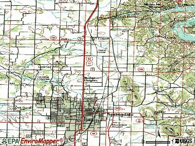
Points of interest:
Notable locations in Bethel Heights: Bethel Heights Police Department (A), Bethel Heights Volunteer Fire Department (B). Display/hide their locations on the map
| This town: | 3.6 people |
| Arkansas: | 2.5 people |
| This town: | 84.8% |
| Whole state: | 67.6% |
| This town: | 8.5% |
| Whole state: | 5.7% |
Likely homosexual households (counted as self-reported same-sex unmarried-partner households)
- Lesbian couples: 0.9% of all households
- Gay men: 0.5% of all households
For population 15 years and over in Bethel Heights:
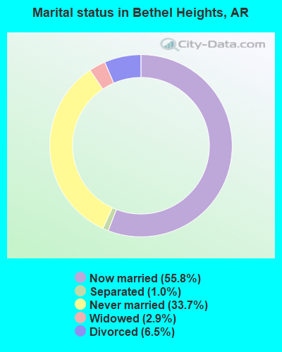
- Never married: 33.7%
- Now married: 55.8%
- Separated: 1.0%
- Widowed: 2.9%
- Divorced: 6.5%
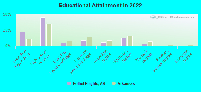
For population 25 years and over in Bethel Heights:
- High school or higher: 73.6%
- Bachelor's degree or higher: 14.3%
- Graduate or professional degree: 2.9%
- Unemployed: 1.8%
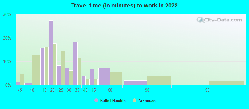
- Mean travel time to work (commute): 22.5 minutes
| Here: | 14.6 |
| Arkansas average: | 11.4 |
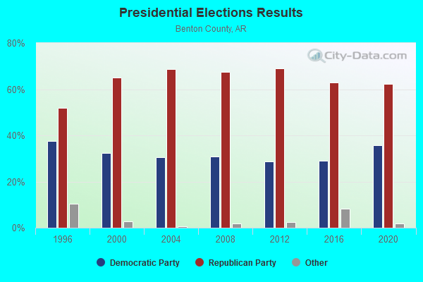
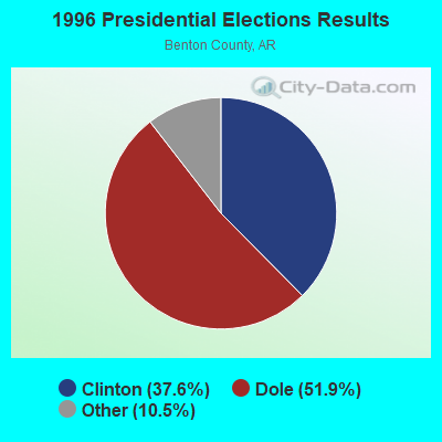
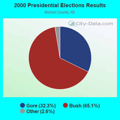
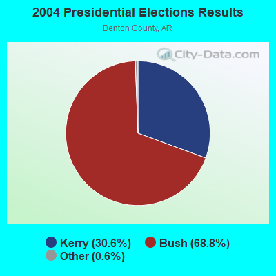


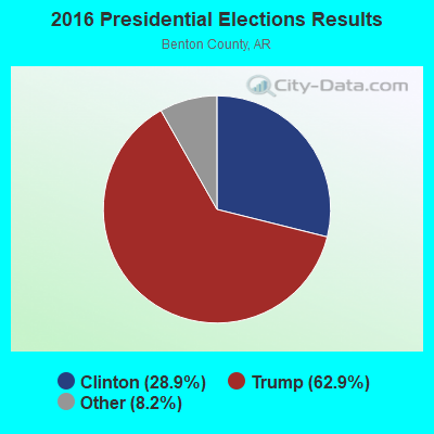
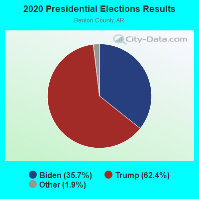
Graphs represent county-level data. Detailed 2008 Election Results
Political contributions by individuals in Bethel Heights, AR
Religion statistics for Bethel Heights, AR (based on Benton County data)
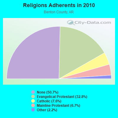
| Religion | Adherents | Congregations |
|---|---|---|
| Evangelical Protestant | 72,566 | 228 |
| Catholic | 16,757 | 4 |
| Mainline Protestant | 14,839 | 43 |
| Other | 4,857 | 20 |
| None | 112,320 | - |
Food Environment Statistics:
| Here: | 1.23 / 10,000 pop. |
| Arkansas: | 2.02 / 10,000 pop. |
| Benton County: | 0.30 / 10,000 pop. |
| Arkansas: | 0.25 / 10,000 pop. |
| Benton County: | 0.35 / 10,000 pop. |
| Arkansas: | 0.59 / 10,000 pop. |
| This county: | 3.90 / 10,000 pop. |
| Arkansas: | 4.94 / 10,000 pop. |
| This county: | 6.42 / 10,000 pop. |
| State: | 6.66 / 10,000 pop. |
| Here: | 7.9% |
| Arkansas: | 9.8% |
| Here: | 27.0% |
| State: | 29.1% |
| This county: | 15.4% |
| State: | 13.6% |
Health and Nutrition:
| Bethel Heights: | 46.6% |
| State: | 48.2% |
| Bethel Heights: | 40.6% |
| State: | 44.2% |
| This city: | 28.9 |
| Arkansas: | 28.9 |
| Bethel Heights: | 23.2% |
| Arkansas: | 21.6% |
| Bethel Heights: | 10.5% |
| Arkansas: | 11.3% |
| Here: | 6.8 |
| Arkansas: | 6.8 |
| Bethel Heights: | 33.8% |
| State: | 34.0% |
| Here: | 52.4% |
| Arkansas: | 54.4% |
| This city: | 76.7% |
| Arkansas: | 78.0% |
More about Health and Nutrition of Bethel Heights, AR Residents
| Local government employment and payroll (March 2017) | |||||
| Function | Full-time employees | Monthly full-time payroll | Average yearly full-time wage | Part-time employees | Monthly part-time payroll |
|---|---|---|---|---|---|
| Police Protection - Officers | 6 | $25,597 | $51,194 | 1 | $45 |
| Sewerage | 3 | $7,706 | $30,824 | 0 | $0 |
| Judicial and Legal | 2 | $3,986 | $23,916 | 0 | $0 |
| Streets and Highways | 2 | $5,403 | $32,418 | 0 | $0 |
| Financial Administration | 1 | $3,853 | $46,236 | 0 | $0 |
| Police - Other | 1 | $2,553 | $30,636 | 0 | $0 |
| Other and Unallocable | 1 | $2,358 | $28,296 | 0 | $0 |
| Firefighters | 0 | $0 | 9 | $4,871 | |
| Other Government Administration | 0 | $0 | 19 | $4,776 | |
| Totals for Government | 16 | $51,456 | $38,592 | 29 | $9,693 |
Bethel Heights government finances - Expenditure in 2017 (per resident):
- Current Operations - Police Protection: $485,000 ($163.30)
Central Staff Services: $327,000 ($110.10)
Sewerage: $200,000 ($67.34)
Financial Administration: $195,000 ($65.66)
Local Fire Protection: $93,000 ($31.31)
Regular Highways: $89,000 ($29.97)
Judicial and Legal Services: $49,000 ($16.50)
Protective Inspection and Regulation - Other: $40,000 ($13.47)
General - Other: $30,000 ($10.10)
Parks and Recreation: $6,000 ($2.02)
Correctional Institutions: $5,000 ($1.68)
- Other Capital Outlay - Sewerage: $188,000 ($63.30)
Police Protection: $62,000 ($20.88)
Regular Highways: $37,000 ($12.46)
Local Fire Protection: $6,000 ($2.02)
Central Staff Services: $2,000 ($0.67)
Parks and Recreation: $2,000 ($0.67)
- Total Salaries and Wages: $718,000 ($241.75)
Bethel Heights government finances - Revenue in 2017 (per resident):
- Charges - Sewerage: $277,000 ($93.27)
- Local Intergovernmental - General Local Government Support: $469,000 ($157.91)
- Miscellaneous - Fines and Forfeits: $131,000 ($44.11)
General Revenue - Other: $17,000 ($5.72)
Rents: $6,000 ($2.02)
Interest Earnings: $1,000 ($0.34)
Donations From Private Sources: $1,000 ($0.34)
- State Intergovernmental - Highways: $157,000 ($52.86)
General Local Government Support: $33,000 ($11.11)
Other: $20,000 ($6.73)
- Tax - General Sales and Gross Receipts: $878,000 ($295.62)
Property: $154,000 ($51.85)
Other License: $70,000 ($23.57)
Public Utilities Sales: $55,000 ($18.52)
Occupation and Business License - Other: $6,000 ($2.02)
Alcoholic Beverage Sales: $1,000 ($0.34)
Bethel Heights government finances - Cash and Securities in 2017 (per resident):
- Other Funds - Cash and Securities: $3,360,000 ($1131.31)
Businesses in Bethel Heights, AR
- MasterBrand Cabinets: 2
Strongest AM radio stations in Bethel Heights:
- KZRA (1590 AM; 2 kW; SPRINGDALE, AR; Owner: CUMULUS LICENSING CORP.)
- KURM (790 AM; 5 kW; ROGERS, AR; Owner: KERM, INC)
- KFAY (1030 AM; 10 kW; FARMINGTON, AR; Owner: CUMULUS LICENSING CORP)
- KREB (1190 AM; daytime; 2 kW; BENTONVILLE/BELLA VI, AR; Owner: BUTLER BROADCASTING COMPANY, LLC)
- KUOA (1290 AM; 5 kW; SILOAM SPRINGS, AR; Owner: KUOA, INC.)
- KZAR (1390 AM; 1 kW; ROGERS, AR; Owner: BUTLER BROADCASTING COMPANY, LLC)
- KFAQ (1170 AM; 50 kW; TULSA, OK; Owner: JOURNAL BROADCAST CORPORATION)
- KRMG (740 AM; 50 kW; TULSA, OK; Owner: CXR HOLDINGS, INC.)
- KBTN (1420 AM; 10 kW; NEOSHO, MO; Owner: PETRACOM OF JOPLIN, L.L.C.)
- KOFC (1250 AM; 1 kW; FAYETTEVILLE, AR; Owner: WILLIAM B. DISNEY & MARTHA J. DISNEY)
- KTHS (1480 AM; 5 kW; BERRYVILLE, AR; Owner: KTHS/KSCC, INC.)
- KGHT (880 AM; 50 kW; SHERIDAN, AR; Owner: METROPOLITAN RADIO GROUP, INC.)
- KYHN (1320 AM; 10 kW; FORT SMITH, AR; Owner: CAPSTAR TX LIMITED PARTNERSHIP)
Strongest FM radio stations in Bethel Heights:
- K203CE (88.5 FM; SPRINGDALE, AR; Owner: BIBLE BROADCASTING NETWORK, INC.)
- KXNA (104.9 FM; SPRINGDALE, AR; Owner: BUTLER BROADCASTING COMPANY, LLC)
- KSEC (95.7 FM; BENTONVILLE, AR; Owner: BENTONVILLE BROADCASTING, LLC)
- KFAY-FM (98.3 FM; BENTONVILLE, AR; Owner: CUMULUS LICENSING CORP)
- KKEG (92.1 FM; FAYETTEVILLE, AR; Owner: CUMULUS LICENSING CORP)
- KMCK-FM (105.7 FM; SILOAM SPRINGS, AR; Owner: CUMULUS LICENSING CORP.)
- KBNV (90.1 FM; FAYETTEVILLE, AR; Owner: AMERICAN FAMILY ASSOCIATION)
- K244DS (96.7 FM; FAYETTEVILLE, AR; Owner: BUTLER BROADCASTING COMPANY, LLC)
- KAYH (89.3 FM; FAYETTEVILLE, AR; Owner: FAMILY VISION MINISTRIES, INC.)
- KAMO-FM (94.3 FM; ROGERS, AR; Owner: CUMULUS LICENSING CORP.)
- KEZA (107.9 FM; FAYETTEVILLE, AR; Owner: CAPSTAR TX LIMITED PARTNERSHIP)
- KMXF (101.9 FM; LOWELL, AR; Owner: CAPSTAR TX LIMITED PARTNERSHIP)
- KUAF (91.3 FM; FAYETTEVILLE, AR; Owner: BOARD OF TRUSTEES OF THE UNIVERSITY OF ARKANSAS)
- K272DQ (102.3 FM; FAYETTEVILLE, AR; Owner: CAPSTAR TX LIMITED PARTNERSHIP)
- KKIX (103.9 FM; FAYETTEVILLE, AR; Owner: CAPSTAR TX LIMITED PARTNERSHIP)
- KIGL (93.3 FM; SELIGMAN, MO; Owner: CAPSTAR TX LIMITED PARTNERSHIP)
- KBVA (106.5 FM; BELLA VISTA, AR; Owner: GAYLA JOY HENDREN)
- KREB-FM (99.5 FM; HUNTSVILLE, AR; Owner: BUTLER BROADCASTING COMPANY, LLC)
- KXUA (88.3 FM; FAYETTEVILLE, AR; Owner: BRD. OF TRUST. OF UNIV. OF ARKANSAS)
- KDAB (94.9 FM; PRAIRIE GROVE, AR; Owner: CUMULUS LICENSING CORP.)
TV broadcast stations around Bethel Heights:
- KFAA (Channel 51; ROGERS, AR; Owner: J.D.G. TELEVISION, INC.)
- KVAQ-LP (Channel 20; SPRINGDALE, AR; Owner: CHRISTIANS INCORPORATED FOR CHRIST)
- K62DQ (Channel 62; FAYETTEVILLE, ETC., AR; Owner: NEW YORK TIMES MANAGEMENT SERVICES)
- K64FO (Channel 64; FAYETTEVILLE, AR; Owner: FORT SMITH 46, INC.)
- K15DR (Channel 15; SPRINGDALE, AR; Owner: FORT SMITH 46, INC.)
- K59ES (Channel 59; HINDSVILLE, AR; Owner: FORT SMITH 46, INC.)
- KFFS-CA (Channel 36; FAYETTEVILLE, AR; Owner: FORT SMITH 46, INC.)
- KSBN-TV (Channel 57; SPRINGDALE, AR; Owner: TOTAL LIFE COMMUNITY EDUCATIONAL FOUNDATION)
- KHOG-TV (Channel 29; FAYETTEVILLE, AR; Owner: KHBS HEARST-ARGYLE TELEVISION, INC.)
- KAFT (Channel 13; FAYETTEVILLE, AR; Owner: ARKANSAS EDUCATIONAL TELEVISION COMMISSION)
- K67EO (Channel 67; BENTONVILLE, AR; Owner: NEW YORK TIMES MANAGEMENT SERVICES)
- K14IT (Channel 14; BENTONVILLE, AR; Owner: FORT SMITH 46, INC.)
- KWBS-TV (Channel 34; EUREKA SPRINGS, AR; Owner: TV 34, INC.)
- K42BS (Channel 42; FAYETTEVILLE, AR; Owner: TRINITY BROADCASTING NETWORK)
- KNJE-LP (Channel 68; EUREKA SPRINGS, AR; Owner: TV-34, INC., AN ARKANSAS CORPORATION)
- K68ET (Channel 68; FORT SMITH, AR; Owner: FORT SMITH 46, INC.)
- K45EI (Channel 45; BENTONVILLE & ROGERS, AR; Owner: VICTORY COMMUNICATIONS, INC.)
- K33FG (Channel 33; SILOAM SPRINGS, AR; Owner: FORT SMITH 46, INC.)
- Bethel Heights, Arkansas
- Fatal accident count10
- Vehicles involved in fatal accidents16
- Fatal accidents involving drunk persons:2
- Fatalities10
- Persons involved in fatal accidents27
- Pedestrians involved in fatal accidents1
- Arkansas average
- Fatal accident count4748
- Vehicles involved in fatal accidents7074
- Fatal accidents involving drunk persons1170
- Fatalities5408
- Persons involved in fatal accidents12066
- Pedestrians involved in fatal accidents364
- National Bridge Inventory (NBI) Statistics
- 2Number of bridges
- 16ft / 4.8mTotal length
- 14,000Total average daily traffic
- 180Total average daily truck traffic
- 16,200Total future (year 2028) average daily traffic
FCC Registered Antenna Towers:
4- Dewey Johnson, North Side Of County Line Road, Approximately 900 Feet West Of Oak Street (Lat: 36.212028 Lon: -94.127444), Type: 53.0, Overall height: 53 m, Registrant: Fletcher, Heald & Hildreth, Plc, Jazzo@fhhlaw.Com, , Arlin-gton, Phone: (703) 812-0470
- Dewey E Johnson, North Side Of County Line Road, Approximately 900 Feet West Of Oak Street (Lat: 36.212028 Lon: -94.127444), Type: 53.0, Structure height: 05007 m, Overall height: 53 m, Registrant: Fletcher, Heald & Hildreth, Plc, Jazzo@fhhlaw.Com, , Arlin-gton, Phone: (703) 812-0470
- Jay Bunyard, North Side Of County Line Road, Approximately 900 Feet West Of Oak Street (Lat: 36.212028 Lon: -94.127444), Type: 53.0, Structure height: 05007 m, Overall height: 53 m, Registrant: Fletcher, Heald & Hildreth, Plc, Jazzo@fhhlaw.Com, 11th Floor, Arlin-gton, Phone: (703) 812-0470
- Musa Salaam, Jefferson Street (Lat: 36.201222 Lon: -94.126167), Type: 39.6, Structure height: 05143 m, Overall height: 36.6 m, Registrant: Environmental Corporation Of America, Eric.Johnson@eca-Usa.Com, , Alpha-retta, Phone: (770) 667-2040
FCC Registered Amateur Radio Licenses:
2- Call Sign: W6URI, Licensee ID: L00206972, Grant Date: 11/07/2017, Expiration Date: 01/14/2028, Certifier: Miguel Urizarri, Registrant: Miguel Urizarri, 3909 Rosebud Ln, Bethel Heights, AR 72764
- Call Sign: KG5ANS, Licensee ID: L01846993, Grant Date: 03/04/2014, Expiration Date: 03/04/2024, Certifier: Tanner C Blair, Registrant: T Blair, 5365 Market Street, Bethel Heights, AR 72764
2002 - 2018 National Fire Incident Reporting System (NFIRS) incidents
- Fire incident types reported to NFIRS in Bethel Heights, AR
- 6244.3%Outside Fires
- 4834.3%Structure Fires
- 2820.0%Mobile Property/Vehicle Fires
- 21.4%Other
 According to the data from the years 2002 - 2018 the average number of fires per year is 8. The highest number of reported fires - 24 took place in 2011, and the least - 2 in 2018. The data has a declining trend.
 When looking into fire subcategories, the most incidents belonged to: Outside Fires (44.3%), and Structure Fires (34.3%).
- 86.5%Utility gas
- 12.7%Electricity
- 0.8%Bottled, tank, or LP gas
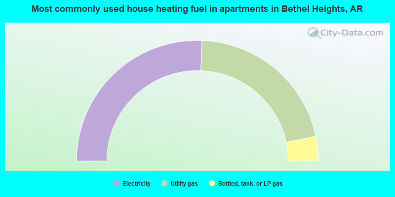
- 51.2%Electricity
- 42.2%Utility gas
- 6.6%Bottled, tank, or LP gas
Bethel Heights compared to Arkansas state average:
- Median household income above state average.
- Unemployed percentage significantly below state average.
- Hispanic race population percentage significantly above state average.
- Median age significantly below state average.
- Foreign-born population percentage significantly above state average.
- Length of stay since moving in significantly below state average.
- House age significantly below state average.
- Number of college students above state average.
Bethel Heights on our top lists:
- #23 on the list of "Top 101 cities with the most residents born in Oceania, n.e.c. (population 500+)"
- #32 on the list of "Top 101 cities with the most residents born in Oceania (population 500+)"
- #67 on the list of "Top 101 cities with the most residents born in El Salvador (population 500+)"
- #72 on the list of "Top 101 cities with the most residents born in Laos (population 500+)"
- #24 on the list of "Top 101 counties with the largest number of people moving in compared to moving out (pop. 50,000+)"
- #74 on the list of "Top 101 counties with the lowest average weight of females"
- #75 on the list of "Top 101 counties with the highest percentage of residents that drank alcohol in the past 30 days"
- #95 on the list of "Top 101 counties with the lowest percentage of residents that visited a dentist within the past year"
- #101 on the list of "Top 101 counties with the lowest percentage of residents that exercised in the past month"

|
Total of 1 patent application in 2008-2024.