Blenheim, New York
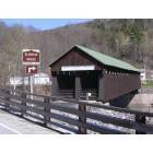
Submit your own pictures of this town and show them to the world
- OSM Map
- Google Map
- MSN Map
Population change since 2000: +14.2%
 |
| Males: 185 | |
| Females: 192 |
| Median resident age: | 46.6 years |
| New York median age: | 40.7 years |
Zip codes: 12093.
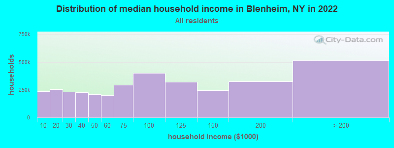
| Blenheim: | $73,530 |
| NY: | $79,557 |
Estimated per capita income in 2022: $44,253 (it was $20,993 in 2000)
Blenheim town income, earnings, and wages data
Estimated median house or condo value in 2022: $164,859 (it was $77,300 in 2000)
| Blenheim: | $164,859 |
| NY: | $400,400 |
Mean prices in 2022: all housing units: $252,981; detached houses: $251,743; townhouses or other attached units: $651,465; in 2-unit structures: $331,466; in 3-to-4-unit structures: $345,769; in 5-or-more-unit structures: $539,440; mobile homes: $176,556
Detailed information about poverty and poor residents in Blenheim, NY


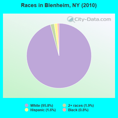
- 36195.8%White alone
- 71.9%Two or more races
- 61.6%Hispanic
- 30.8%Black alone
Races in Blenheim detailed stats: ancestries, foreign born residents, place of birth
 Recent articles from our blog. Our writers, many of them Ph.D. graduates or candidates, create easy-to-read articles on a wide variety of topics.

Ancestries: German (24.2%), Irish (11.2%), Dutch (9.7%), English (8.5%), Italian (6.7%), United States (6.1%).
Current Local Time: EST time zone
Land area: 33.9 square miles.
Population density: 11 people per square mile (very low).
16 residents are foreign born (3.6% Europe, 0.6% Latin America, 0.6% North America).
| This town: | 4.8% |
| New York: | 20.4% |
| Blenheim town: | 1.7% ($1,309) |
| New York: | 1.9% ($2,847) |
Nearest city with pop. 50,000+: Schenectady, NY  (36.4 miles , pop. 61,821).
Nearest city with pop. 200,000+: Bronx, NY (117.9 miles , pop. 1,332,650).
Nearest cities:
), ), ), ), Latitude: 42.49 N, Longitude: 74.50 W
Area code commonly used in this area: 518
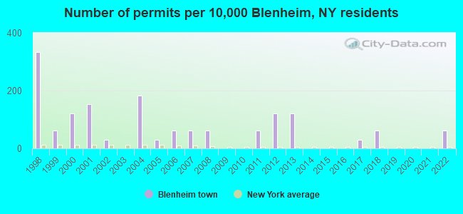
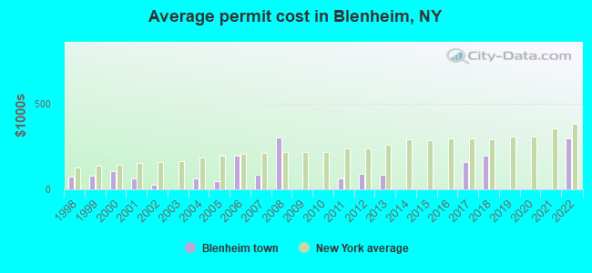
Single-family new house construction building permits:
- 2022: 2 buildings, average cost: $297,500
- 2018: 2 buildings, average cost: $200,000
- 2017: 1 building, cost: $160,000
- 2013: 4 buildings, average cost: $87,500
- 2012: 4 buildings, average cost: $93,200
- 2011: 2 buildings, average cost: $62,500
- 2008: 2 buildings, average cost: $305,000
- 2007: 2 buildings, average cost: $84,500
- 2006: 2 buildings, average cost: $199,300
- 2005: 1 building, cost: $48,200
- 2004: 6 buildings, average cost: $62,300
- 2002: 1 building, cost: $25,000
- 2001: 5 buildings, average cost: $62,400
- 2000: 4 buildings, average cost: $107,400
- 1999: 2 buildings, average cost: $79,000
- 1998: 11 buildings, average cost: $74,600
| Here: | 4.5% |
| New York: | 4.4% |
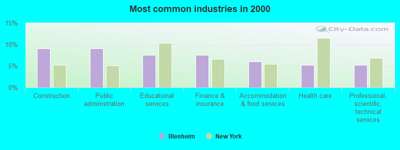
- Construction (9.0%)
- Public administration (9.0%)
- Educational services (7.5%)
- Finance & insurance (7.5%)
- Accommodation & food services (6.0%)
- Health care (5.3%)
- Professional, scientific, technical services (5.3%)
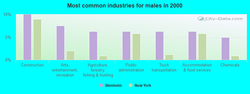
- Construction (10.0%)
- Arts, entertainment, recreation (7.5%)
- Agriculture, forestry, fishing & hunting (6.2%)
- Public administration (6.2%)
- Truck transportation (6.2%)
- Accommodation & food services (6.2%)
- Chemicals (5.0%)
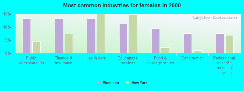
- Public administration (13.2%)
- Finance & insurance (13.2%)
- Health care (13.2%)
- Educational services (11.3%)
- Food & beverage stores (9.4%)
- Construction (7.5%)
- Professional, scientific, technical services (7.5%)
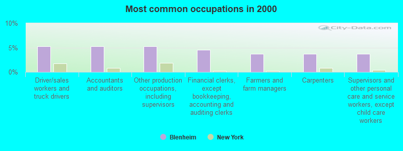
- Driver/sales workers and truck drivers (5.3%)
- Accountants and auditors (5.3%)
- Other production occupations, including supervisors (5.3%)
- Financial clerks, except bookkeeping, accounting and auditing clerks (4.5%)
- Farmers and farm managers (3.8%)
- Carpenters (3.8%)
- Supervisors and other personal care and service workers, except child care workers (3.8%)
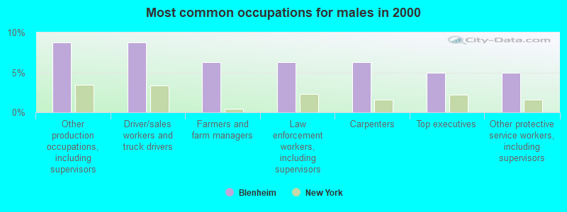
- Other production occupations, including supervisors (8.8%)
- Driver/sales workers and truck drivers (8.8%)
- Farmers and farm managers (6.2%)
- Law enforcement workers, including supervisors (6.2%)
- Carpenters (6.2%)
- Top executives (5.0%)
- Other protective service workers, including supervisors (5.0%)
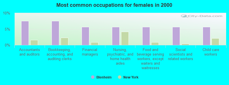
- Accountants and auditors (7.5%)
- Bookkeeping, accounting, and auditing clerks (7.5%)
- Financial managers (5.7%)
- Nursing, psychiatric, and home health aides (5.7%)
- Food and beverage serving workers, except waiters and waitresses (5.7%)
- Social scientists and related workers (5.7%)
- Child care workers (5.7%)
Average climate in Blenheim, New York
Based on data reported by over 4,000 weather stations


(lower is better)
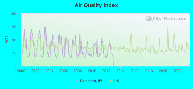
Air Quality Index (AQI) level in 2012 was 56.9. This is better than average.
| City: | 56.9 |
| U.S.: | 72.6 |
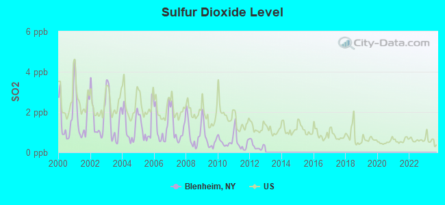
Sulfur Dioxide (SO2) [ppb] level in 2012 was 0.314. This is significantly better than average. Closest monitor was 23.7 miles away from the city center.
| City: | 0.314 |
| U.S.: | 1.515 |
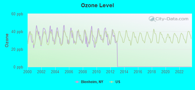
Ozone [ppb] level in 2012 was 32.5. This is about average. Closest monitor was 23.7 miles away from the city center.
| City: | 32.5 |
| U.S.: | 33.3 |
Tornado activity:
Blenheim-area historical tornado activity is slightly above New York state average. It is 57% smaller than the overall U.S. average.
On 7/10/1989, a category F4 (max. wind speeds 207-260 mph) tornado 23.8 miles away from the Blenheim town center injured 20 people and caused between $5,000,000 and $50,000,000 in damages.
On 5/31/1998, a category F3 (max. wind speeds 158-206 mph) tornado 22.9 miles away from the town center injured 3 people and caused $800,000 in damages.
Earthquake activity:
Blenheim-area historical earthquake activity is significantly above New York state average. It is 67% smaller than the overall U.S. average.On 10/7/1983 at 10:18:46, a magnitude 5.3 (5.1 MB, 5.3 LG, 5.1 ML, Class: Moderate, Intensity: VI - VII) earthquake occurred 101.8 miles away from Blenheim center
On 4/20/2002 at 10:50:47, a magnitude 5.3 (5.3 ML, Depth: 3.0 mi) earthquake occurred 145.8 miles away from Blenheim center
On 4/20/2002 at 10:50:47, a magnitude 5.2 (5.2 MB, 4.2 MS, 5.2 MW, 5.0 MW) earthquake occurred 143.8 miles away from Blenheim center
On 6/17/1991 at 08:53:16, a magnitude 4.1 (4.0 MB, 4.0 LG, Depth: 3.1 mi, Class: Light, Intensity: IV - V) earthquake occurred 13.5 miles away from the city center
On 8/23/2011 at 17:51:04, a magnitude 5.8 (5.8 MW, Depth: 3.7 mi) earthquake occurred 364.9 miles away from the city center
On 1/19/1982 at 00:14:42, a magnitude 4.7 (4.5 MB, 4.7 MD, 4.5 LG) earthquake occurred 162.5 miles away from the city center
Magnitude types: regional Lg-wave magnitude (LG), body-wave magnitude (MB), duration magnitude (MD), local magnitude (ML), surface-wave magnitude (MS), moment magnitude (MW)
Natural disasters:
The number of natural disasters in Schoharie County (26) is a lot greater than the US average (15).Major Disasters (Presidential) Declared: 15
Emergencies Declared: 10
Causes of natural disasters: Floods: 8, Storms: 8, Hurricanes: 5, Snowstorms: 3, Winter Storms: 3, Tropical Storms: 2, Blizzard: 1, Power Outage: 1, Tropical Depression: 1, Other: 2 (Note: some incidents may be assigned to more than one category).
Colleges/universities with over 2000 students nearest to Blenheim:
- SUNY College of Agriculture and Technology at Cobleskill (about 13 miles; Cobleskill, NY; Full-time enrollment: 2,455)
- SUNY College of Technology at Delhi (about 27 miles; Delhi, NY; FT enrollment: 2,911)
- SUNY Oneonta (about 29 miles; Oneonta, NY; FT enrollment: 6,081)
- Excelsior College (about 36 miles; Albany, NY; FT enrollment: 4,723)
- Fulton-Montgomery Community College (about 36 miles; Johnstown, NY; FT enrollment: 2,043)
- Schenectady County Community College (about 37 miles; Schenectady, NY; FT enrollment: 3,676)
- Union College (about 37 miles; Schenectady, NY; FT enrollment: 2,075)
Points of interest:
Notable location: Ruth (A). Display/hide its location on the map
Churches in Blenheim include: Brimstone Church (A), United Methodist Church (B). Display/hide their locations on the map
Cemeteries: Shafer Cemetery (1), Blenheim Hill Cemetery (2), Hager Cemetery (3), New Eminence Cemetery (4), Knisker Cemetery (5), Champlin Cemetery (6). Display/hide their locations on the map
Reservoir: Blenheim Gilboa Reservoir (A). Display/hide its location on the map
Streams, rivers, and creeks: West Kill (A), Betty Brook (B), Mine Kill (C), Mill Creek (D). Display/hide their locations on the map
Park in Blenheim: Mine Kill State Park (1). Display/hide its location on the map
Birthplace of: Fred Buckingham - Baseball player.
| This town: | 2.4 people |
| New York: | 2.6 people |
| This town: | 63.3% |
| Whole state: | 63.5% |
| This town: | 10.1% |
| Whole state: | 6.8% |
Likely homosexual households (counted as self-reported same-sex unmarried-partner households)
- Lesbian couples: 0.6% of all households
- Gay men: 0.0% of all households
| This town: | 8.5% |
| Whole state: | 14.6% |
| This town: | 2.7% |
| Whole state: | 7.4% |
For population 15 years and over in Blenheim:
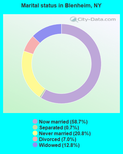
- Never married: 20.8%
- Now married: 58.7%
- Separated: 0.7%
- Widowed: 12.8%
- Divorced: 7.0%
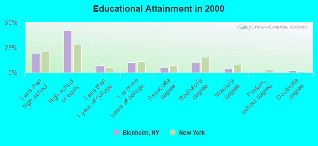
For population 25 years and over in Blenheim:
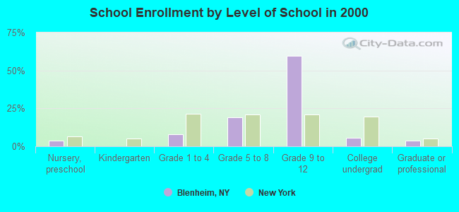
- High school or higher: 80.5%
- Bachelor's degree or higher: 16.2%
- Graduate or professional degree: 6.4%
- Unemployed: 11.3%
- Mean travel time to work (commute): 33.3 minutes
| Here: | 13.3 |
| New York average: | 14.2 |
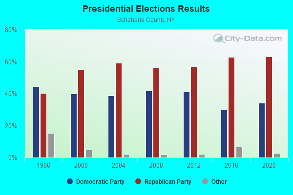
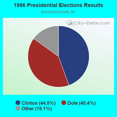
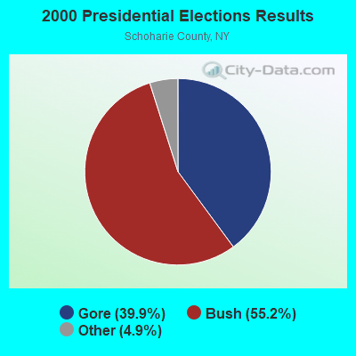
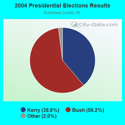
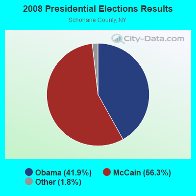
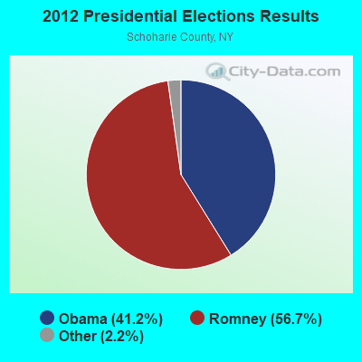
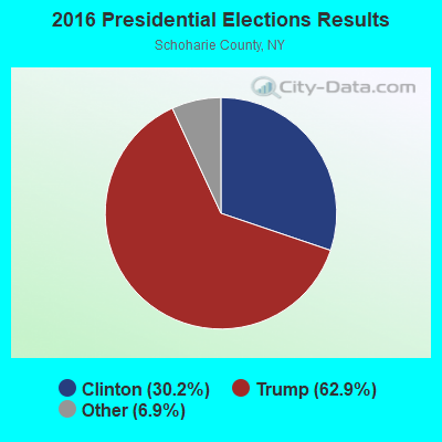
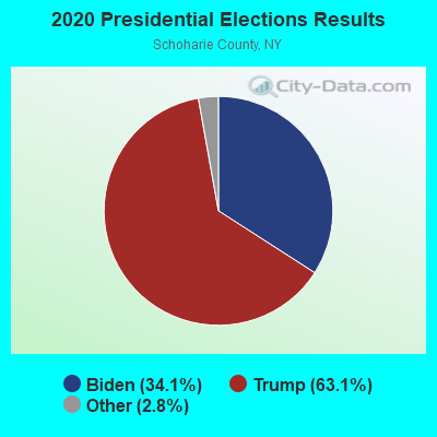
Graphs represent county-level data. Detailed 2008 Election Results
Religion statistics for Blenheim, NY (based on Schoharie County data)
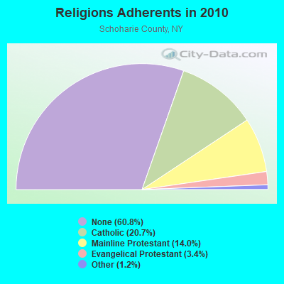
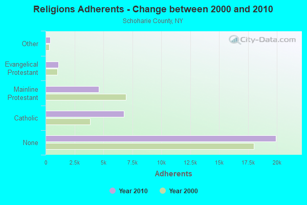
| Religion | Adherents | Congregations |
|---|---|---|
| Catholic | 6,768 | 3 |
| Mainline Protestant | 4,578 | 36 |
| Evangelical Protestant | 1,099 | 19 |
| Other | 391 | 2 |
| Orthodox | - | - |
| None | 19,913 | - |
Food Environment Statistics:
| Schoharie County: | 0.63 / 10,000 pop. |
| New York: | 4.13 / 10,000 pop. |
| Here: | 0.31 / 10,000 pop. |
| State: | 0.06 / 10,000 pop. |
| This county: | 0.31 / 10,000 pop. |
| State: | 0.92 / 10,000 pop. |
| Schoharie County: | 5.95 / 10,000 pop. |
| State: | 1.68 / 10,000 pop. |
| Here: | 7.83 / 10,000 pop. |
| New York: | 8.82 / 10,000 pop. |
| Schoharie County: | 8.9% |
| State: | 8.2% |
| Here: | 24.3% |
| New York: | 23.8% |
| Schoharie County: | 13.2% |
| New York: | 15.6% |
Strongest AM radio stations in Blenheim:
- WGY (810 AM; 50 kW; SCHENECTADY, NY; Owner: CLEAR CHANNEL BROADCASTING LICENSES, INC.)
- WPTR (1540 AM; 50 kW; ALBANY, NY; Owner: KIMTRON, INC.)
- WNNZ (640 AM; 50 kW; WESTFIELD, MA; Owner: CLEAR CHANNEL BROADCASTING LICENSES, INC.)
- WROW (590 AM; 5 kW; ALBANY, NY; Owner: 6 JOHNSON ROAD LICENSES, INC.)
- WMCA (570 AM; 50 kW; NEW YORK, NY; Owner: SALEM MEDIA OF NEW YORK, LLC)
- WFAN (660 AM; 50 kW; NEW YORK, NY; Owner: INFINITY BROADCASTING OPERATIONS, INC.)
- WABC (770 AM; 50 kW; NEW YORK, NY; Owner: WABC-AM RADIO, INC.)
- WOR (710 AM; 50 kW; NEW YORK, NY; Owner: BUCKLEY BROADCASTING CORPORATION)
- WTIC (1080 AM; 50 kW; HARTFORD, CT; Owner: INFINITY RADIO OPERATIONS INC.)
- WXBH (1190 AM; 1 kW; COBLESKILL, NY; Owner: NY COMMUNICATIONS, LLC)
- WCBS (880 AM; 50 kW; NEW YORK, NY; Owner: INFINITY BROADCASTING OPERATIONS, INC.)
- WINS (1010 AM; 50 kW; NEW YORK, NY; Owner: INFINITY BROADCASTING OPERATIONS, INC.)
- WEPN (1050 AM; 50 kW; NEW YORK, NY; Owner: NEW YORK AM RADIO, LLC)
Strongest FM radio stations in Blenheim:
- WGKR (105.3 FM; GRAND GORGE, NY; Owner: SOUND OF LIFE, INC.)
- WRIP (97.9 FM; WINDHAM, NY; Owner: RIP RADIO, LLC)
- WMYY (97.3 FM; SCHOHARIE, NY; Owner: CAPITAL MEDIA CORPORATION)
- WJIV (101.9 FM; CHERRY VALLEY, NY; Owner: CHRISTIAN BROADCASTING SYSTEM, LTD.)
- WAJZ (96.3 FM; VOORHEESVILLE, NY; Owner: 6 JOHNSON ROAD LICENSES, INC.)
- WDHI (100.3 FM; DELHI, NY; Owner: BANJO COMMUNICATIONS GROUP, INC.)
- WZMR (104.9 FM; ALTAMONT, NY; Owner: 6 JOHNSON ROAD LICENSES, INC.)
- WAMK (90.9 FM; KINGSTON, NY; Owner: W A M C)
- WFGB (89.7 FM; KINGSTON, NY; Owner: SOUND OF LIFE, INC.)
- WYJB (95.5 FM; ALBANY, NY; Owner: 6 JOHNSON ROAD LICENSES, INC.)
- WGNA-FM (107.7 FM; ALBANY, NY; Owner: REGENT LICENSEE OF MANSFIELD, INC.)
- WMHT-FM (89.1 FM; SCHENECTADY, NY; Owner: WMHT EDUCATIONAL TELECOMMUNICATIONS)
- WRVE (99.5 FM; SCHENECTADY, NY; Owner: CLEAR CHANNEL BROADCASTING LICENSES, INC.)
- WPYX (106.5 FM; ALBANY, NY; Owner: CAPSTAR TX LIMITED PARTNERSHIP)
- WVCR-FM (88.3 FM; LOUDONVILLE, NY; Owner: SIENA COLLEGE)
- WFLY (92.3 FM; TROY, NY; Owner: 6 JOHNSON ROAD LICENSES, INC.)
- WFKP (99.3 FM; ELLENVILLE, NY; Owner: CLEAR CHANNEL BROADCASTING LICENSES, INC.)
- WBUG-FM (101.1 FM; FORT PLAIN, NY; Owner: ROSER COMMUNICATIONS NETWORK, INC.)
- WSQC-FM (91.7 FM; ONEONTA, NY; Owner: WSKG PUBLIC TELECOMM. COUNCIL)
- WPGL (90.7 FM; PATTERSONVILLE, NY; Owner: SOUND OF LIFE, INC.)
TV broadcast stations around Blenheim:
- WNYT (Channel 13; ALBANY, NY; Owner: WNYT-TV, LLC)
- WEWB-TV (Channel 45; SCHENECTADY, NY; Owner: WEWB, L.L.C.)
- WRGB (Channel 6; SCHENECTADY, NY; Owner: FREEDOM BROADCASTING OF NEW YORK, INC)
- WMHT (Channel 17; SCHENECTADY, NY; Owner: WMHT EDUCATIONAL TELECOMMUNICATIONS)
- WTEN (Channel 10; ALBANY, NY; Owner: YOUNG BROADCASTING OF ALBANY, INC.)
- WXXA-TV (Channel 23; ALBANY, NY; Owner: CLEAR CHANNEL BROADCASTING LICENSES, INC.)
- National Bridge Inventory (NBI) Statistics
- 8Number of bridges
- 98ft / 30.0mTotal length
- $13,448,000Total costs
- 4,733Total average daily traffic
- 629Total average daily truck traffic
- 5,257Total future (year 2037) average daily traffic
Blenheim compared to New York state average:
- Median house value significantly below state average.
- Black race population percentage significantly below state average.
- Hispanic race population percentage significantly below state average.
- Median age above state average.
- Foreign-born population percentage significantly below state average.
- Renting percentage significantly below state average.
- Length of stay since moving in significantly above state average.
- Number of rooms per house significantly below state average.
- House age significantly below state average.
- Number of college students significantly below state average.
- Percentage of population with a bachelor's degree or higher below state average.