Bridgewater, Connecticut
Submit your own pictures of this town and show them to the world
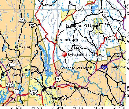
- OSM Map
- General Map
- Google Map
- MSN Map
Population change since 2000: -5.3%
 |
| Males: 860 | |
| Females: 867 |
| Median resident age: | 51.3 years |
| Connecticut median age: | 39.2 years |
Zip codes: 06752.
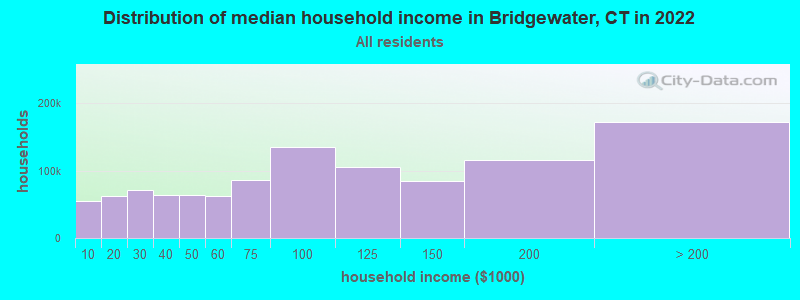
| Bridgewater: | $131,852 |
| CT: | $88,429 |
Estimated per capita income in 2022: $76,217 (it was $42,505 in 2000)
Bridgewater town income, earnings, and wages data
Estimated median house or condo value in 2022: $641,434 (it was $296,700 in 2000)
| Bridgewater: | $641,434 |
| CT: | $347,200 |
Mean prices in 2022: all housing units: $429,743; detached houses: $455,293; townhouses or other attached units: $232,674; in 2-unit structures: $242,050; in 3-to-4-unit structures: $229,634; in 5-or-more-unit structures: $182,162; mobile homes: $243,504; occupied boats, rvs, vans, etc.: $127,144
Detailed information about poverty and poor residents in Bridgewater, CT


- 1,66196.2%White alone
- 261.5%Hispanic
- 150.9%Asian alone
- 130.8%Black alone
- 60.3%Other race alone
- 60.3%Two or more races
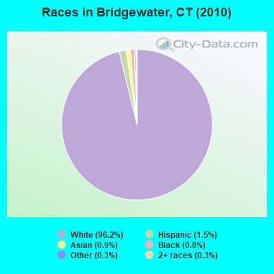
Races in Bridgewater detailed stats: ancestries, foreign born residents, place of birth
According to our research of Connecticut and other state lists, there was 1 registered sex offender living in Bridgewater, Connecticut as of May 21, 2024.
The ratio of all residents to sex offenders in Bridgewater is 1,727 to 1.
The ratio of registered sex offenders to all residents in this city is lower than the state average.
 Recent articles from our blog. Our writers, many of them Ph.D. graduates or candidates, create easy-to-read articles on a wide variety of topics.

 | 2024 Connecticut Town Tournament VI (Celebrating the 10-Year Anniversary & Dazzleman's Memorial) (998 replies) |
| Desegregate Connecticut---Raised CT Zoning Bill (2519 replies) |
| Is Norwich Commutable to NYC? (100 replies) |
| Connecticut TOWN TOURNAMENT V (2022) (831 replies) |
| Connecticut Fall Foliage (380 replies) |
| Metro Stamford Development/Construction Thread (2387 replies) |
Latest news from Bridgewater, CT collected exclusively by city-data.com from local newspapers, TV, and radio stations
Ancestries: Irish (23.5%), English (22.3%), German (17.1%), Italian (15.4%), United States (4.6%), Swedish (4.4%).
Current Local Time: EST time zone
Incorporated on 05/1856
Elevation: 650 feet
Land area: 16.2 square miles.
Population density: 106 people per square mile (very low).
68 residents are foreign born (2.7% Europe, 0.9% Asia).
| This town: | 3.7% |
| Connecticut: | 10.9% |
| Bridgewater town: | 1.1% ($3,376) |
| Connecticut: | 1.8% ($2,961) |
Nearest city with pop. 50,000+: Danbury, CT  (9.9 miles , pop. 74,848).
Nearest city with pop. 200,000+: Bronx, NY (54.0 miles , pop. 1,332,650).
Nearest cities:
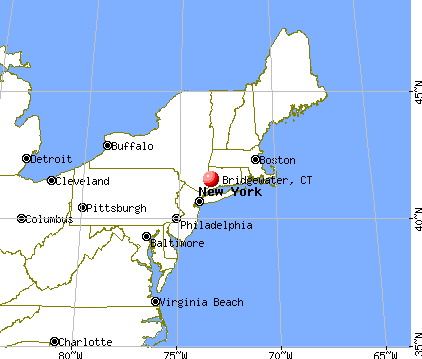
), ), )Latitude: 41.53 N, Longitude: 73.36 W
Area code commonly used in this area: 860

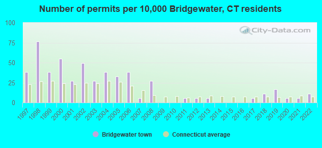
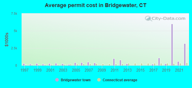
Single-family new house construction building permits:
- 2022: 2 buildings, average cost: $3,160,000
- 2021: 1 building, cost: $600,000
- 2020: 1 building, cost: $6,000,000
- 2019: 3 buildings, average cost: $270,000
- 2018: 2 buildings, average cost: $1,117,500
- 2017: 1 building, cost: $220,000
- 2013: 1 building, cost: $250,000
- 2012: 1 building, cost: $800,000
- 2011: 1 building, cost: $1,000,000
- 2008: 5 buildings, average cost: $397,800
- 2007: 1 building, cost: $505,000
- 2006: 7 buildings, average cost: $424,300
- 2005: 6 buildings, average cost: $406,200
- 2004: 7 buildings, average cost: $188,600
- 2003: 5 buildings, average cost: $253,000
- 2002: 9 buildings, average cost: $318,500
- 2001: 5 buildings, average cost: $285,400
- 2000: 10 buildings, average cost: $230,100
- 1999: 7 buildings, average cost: $298,900
- 1998: 14 buildings, average cost: $225,900
- 1997: 7 buildings, average cost: $302,300
| Here: | 3.5% |
| Connecticut: | 3.9% |
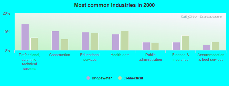
- Professional, scientific, technical services (14.0%)
- Construction (10.4%)
- Educational services (9.8%)
- Health care (8.6%)
- Public administration (4.4%)
- Finance & insurance (4.3%)
- Accommodation & food services (3.0%)
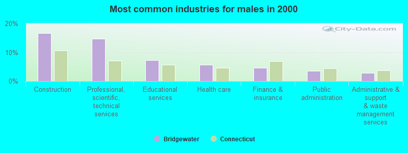
- Construction (16.7%)
- Professional, scientific, technical services (14.7%)
- Educational services (7.2%)
- Health care (5.6%)
- Finance & insurance (4.5%)
- Public administration (3.6%)
- Administrative & support & waste management services (2.9%)
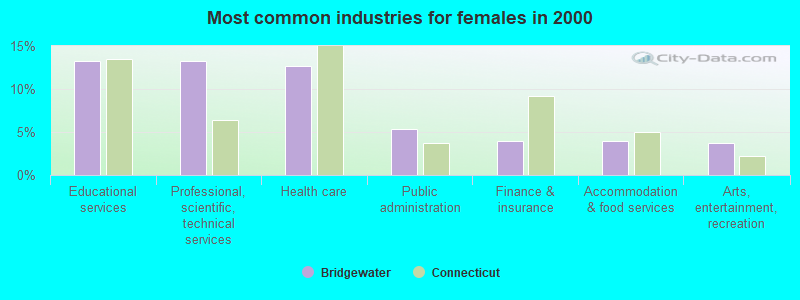
- Educational services (13.2%)
- Professional, scientific, technical services (13.2%)
- Health care (12.7%)
- Public administration (5.4%)
- Finance & insurance (3.9%)
- Accommodation & food services (3.9%)
- Arts, entertainment, recreation (3.7%)
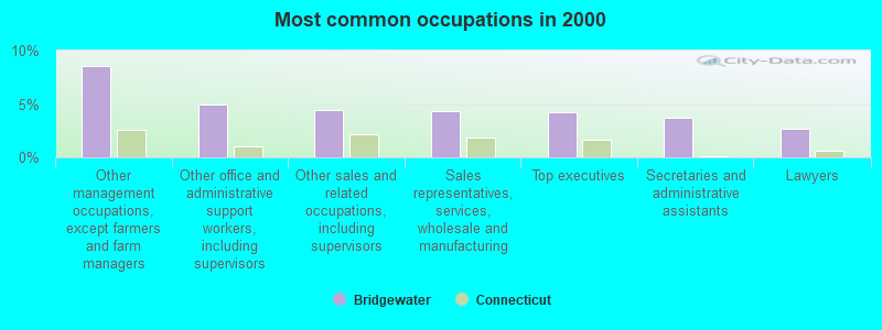
- Other management occupations, except farmers and farm managers (8.5%)
- Other office and administrative support workers, including supervisors (5.0%)
- Other sales and related occupations, including supervisors (4.5%)
- Sales representatives, services, wholesale and manufacturing (4.4%)
- Top executives (4.3%)
- Secretaries and administrative assistants (3.7%)
- Lawyers (2.7%)
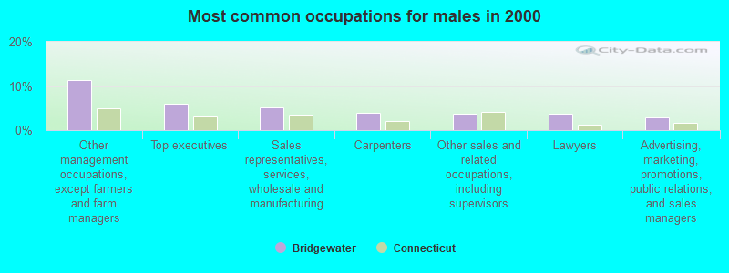
- Other management occupations, except farmers and farm managers (11.4%)
- Top executives (6.0%)
- Sales representatives, services, wholesale and manufacturing (5.1%)
- Carpenters (4.0%)
- Other sales and related occupations, including supervisors (3.8%)
- Lawyers (3.6%)
- Advertising, marketing, promotions, public relations, and sales managers (2.9%)
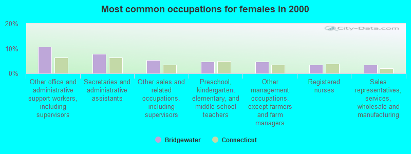
- Other office and administrative support workers, including supervisors (10.8%)
- Secretaries and administrative assistants (7.8%)
- Other sales and related occupations, including supervisors (5.4%)
- Preschool, kindergarten, elementary, and middle school teachers (4.6%)
- Other management occupations, except farmers and farm managers (4.6%)
- Registered nurses (3.4%)
- Sales representatives, services, wholesale and manufacturing (3.4%)
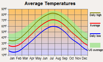
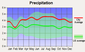
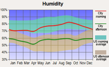
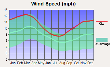
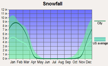
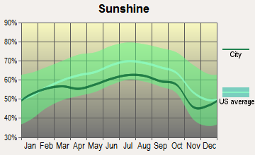
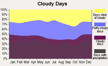
Average climate in Bridgewater, Connecticut
Based on data reported by over 4,000 weather stations
(lower is better)
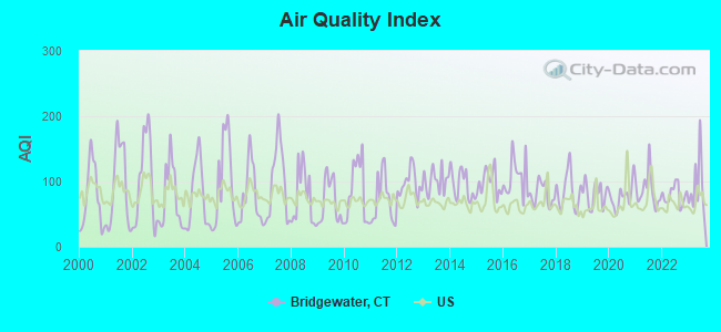
Air Quality Index (AQI) level in 2023 was 92.0. This is worse than average.
| City: | 92.0 |
| U.S.: | 72.6 |
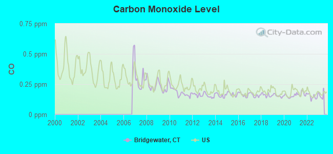
Carbon Monoxide (CO) [ppm] level in 2022 was 0.149. This is significantly better than average. Closest monitor was 16.5 miles away from the city center.
| City: | 0.149 |
| U.S.: | 0.251 |
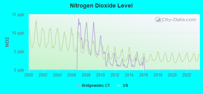
Nitrogen Dioxide (NO2) [ppb] level in 2015 was 2.27. This is significantly better than average. Closest monitor was 9.6 miles away from the city center.
| City: | 2.27 |
| U.S.: | 5.11 |
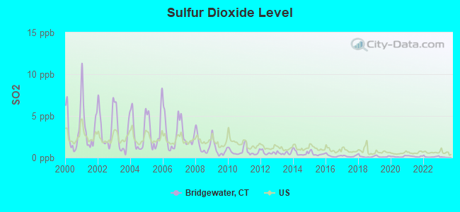
Sulfur Dioxide (SO2) [ppb] level in 2022 was 0.109. This is significantly better than average. Closest monitor was 9.6 miles away from the city center.
| City: | 0.109 |
| U.S.: | 1.515 |
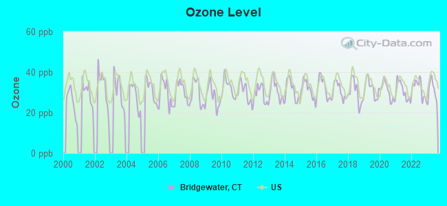
Ozone [ppb] level in 2023 was 31.0. This is about average. Closest monitor was 9.8 miles away from the city center.
| City: | 31.0 |
| U.S.: | 33.3 |
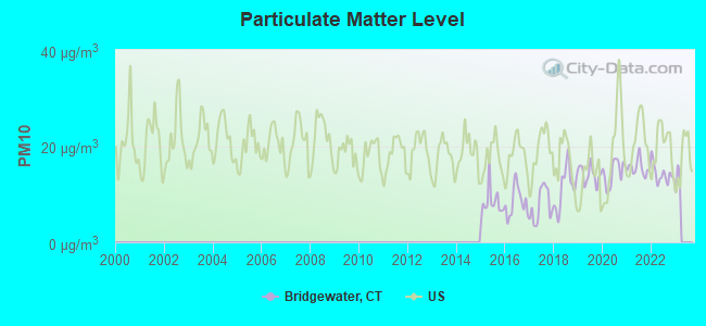
Particulate Matter (PM10) [µg/m3] level in 2022 was 14.2. This is better than average. Closest monitor was 9.8 miles away from the city center.
| City: | 14.2 |
| U.S.: | 19.2 |
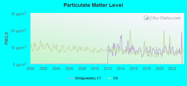
Particulate Matter (PM2.5) [µg/m3] level in 2022 was 6.99. This is about average. Closest monitor was 9.8 miles away from the city center.
| City: | 6.99 |
| U.S.: | 8.11 |
Tornado activity:
Bridgewater-area historical tornado activity is near Connecticut state average. It is 26% smaller than the overall U.S. average.
On 7/10/1989, a category F4 (max. wind speeds 207-260 mph) tornado 25.9 miles away from the Bridgewater town center injured 40 people and caused between $50,000,000 and $500,000,000 in damages.
On 5/24/1962, a category F3 (max. wind speeds 158-206 mph) tornado 12.6 miles away from the town center killed one person and injured 50 people and caused between $500,000 and $5,000,000 in damages.
Earthquake activity:
Bridgewater-area historical earthquake activity is significantly above Connecticut state average. It is 69% smaller than the overall U.S. average.On 10/7/1983 at 10:18:46, a magnitude 5.3 (5.1 MB, 5.3 LG, 5.1 ML, Class: Moderate, Intensity: VI - VII) earthquake occurred 175.1 miles away from the city center
On 4/20/2002 at 10:50:47, a magnitude 5.3 (5.3 ML, Depth: 3.0 mi) earthquake occurred 207.3 miles away from Bridgewater center
On 4/20/2002 at 10:50:47, a magnitude 5.2 (5.2 MB, 4.2 MS, 5.2 MW, 5.0 MW) earthquake occurred 205.6 miles away from the city center
On 8/23/2011 at 17:51:04, a magnitude 5.8 (5.8 MW, Depth: 3.7 mi) earthquake occurred 348.9 miles away from the city center
On 1/19/1982 at 00:14:42, a magnitude 4.7 (4.5 MB, 4.7 MD, 4.5 LG, Class: Light, Intensity: IV - V) earthquake occurred 163.4 miles away from Bridgewater center
On 1/16/1994 at 01:49:16, a magnitude 4.6 (4.6 MB, 4.6 LG, Depth: 3.1 mi) earthquake occurred 162.5 miles away from the city center
Magnitude types: regional Lg-wave magnitude (LG), body-wave magnitude (MB), duration magnitude (MD), local magnitude (ML), surface-wave magnitude (MS), moment magnitude (MW)
Natural disasters:
The number of natural disasters in Litchfield County (23) is greater than the US average (15).Major Disasters (Presidential) Declared: 13
Emergencies Declared: 10
Causes of natural disasters: Storms: 7, Hurricanes: 5, Floods: 4, Snowstorms: 4, Blizzards: 3, Snows: 2, Tropical Storms: 2, Winter Storms: 2, Snowfall: 1, Tornado: 1, Wind: 1 (Note: some incidents may be assigned to more than one category).
Hospitals and medical centers near Bridgewater:
- ABILITY BEYOND DISABILITY GREE (Hospital, about 2 miles away; NEW MILFORD, CT)
- ABILITY BEYOND DISABILITY LONG (Hospital, about 3 miles away; BROOKFIELD, CT)
- ABILITY BEYOND DISABILITY LANE (Hospital, about 4 miles away; NEW MILFORD, CT)
- ABILITY BEYOND DISABILITY DORSET LANE (Hospital, about 4 miles away; BROOKFIELD, CT)
- NEW MILFORD HOSPITAL Acute Care Hospitals (about 5 miles away; NEW MILFORD, CT)
- VILLAGE CREST CENTER FOR HEALTH AND REHABILITATION (Nursing Home, about 5 miles away; NEW MILFORD, CT)
- CANDLEWOOD VALLEY HEALTH AND R (Nursing Home, about 6 miles away; NEW MILFORD, CT)
Colleges/universities with over 2000 students nearest to Bridgewater:
- Western Connecticut State University (about 10 miles; Danbury, CT; Full-time enrollment: 5,345)
- Post University (about 15 miles; Waterbury, CT; FT enrollment: 5,808)
- Naugatuck Valley Community College (about 16 miles; Waterbury, CT; FT enrollment: 4,491)
- University of Connecticut-Tri-Campus (about 17 miles; Waterbury, CT; FT enrollment: 2,250)
- Sacred Heart University (about 22 miles; Fairfield, CT; FT enrollment: 5,650)
- Quinnipiac University (about 26 miles; Hamden, CT; FT enrollment: 8,153)
- Southern Connecticut State University (about 26 miles; New Haven, CT; FT enrollment: 8,708)
Public elementary/middle school in Bridgewater:
- THE BURNHAM SCHOOL (Students: 139, Location: 80 MAIN STREET, Grades: KG-5)
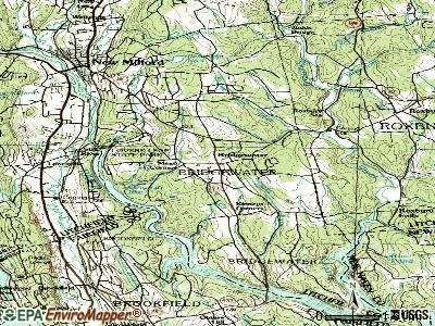
Points of interest:
Notable locations in Bridgewater: Kinneys Corners (A), Mead Corners (B), Burnham Library (C), Bridgewater Volunteer Fire Department (D). Display/hide their locations on the map
Church in Bridgewater: Bridgewater Congregational Church (A). Display/hide its location on the map
Cemetery: South Cemetery (1). Display/hide its location on the map
Reservoir: Wewaka Brook Pond (A). Display/hide its location on the map
Streams, rivers, and creeks: Clapboard Oak Brook (A), Wewaka Brook (B), Town Farm Brook (C), Hitchcock Mill Brook (D). Display/hide their locations on the map
Park in Bridgewater: Bridgwater Green (1). Display/hide its location on the map
| This town: | 2.3 people |
| Connecticut: | 2.5 people |
| This town: | 71.4% |
| Whole state: | 66.3% |
| This town: | 4.6% |
| Whole state: | 6.6% |
Likely homosexual households (counted as self-reported same-sex unmarried-partner households)
- Lesbian couples: 0.8% of all households
- Gay men: 0.5% of all households
| This town: | 4.1% |
| Whole state: | 7.9% |
| This town: | 2.0% |
| Whole state: | 3.9% |
People in group quarters in Bridgewater in 2000:
- 22 people in homes or halfway houses for drug/alcohol abuse
- 9 people in other workers' dormitories
- 2 people in agriculture workers' dormitories on farms
Banks with branches in Bridgewater (2011 data):
- Union Savings Bank: Bridgewater Branch at 29 Main Street, branch established on 2003/09/22. Info updated 2011/11/30: Bank assets: $2,496.5 mil, Deposits: $1,625.1 mil, headquarters in Danbury, CT, positive income, Mortgage Lending Specialization, 29 total offices
For population 15 years and over in Bridgewater:

- Never married: 19.2%
- Now married: 66.0%
- Separated: 1.1%
- Widowed: 5.6%
- Divorced: 8.1%
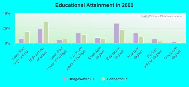
For population 25 years and over in Bridgewater:
- High school or higher: 93.3%
- Bachelor's degree or higher: 48.2%
- Graduate or professional degree: 21.3%
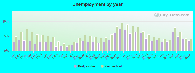
- Unemployed: 4.9%
- Mean travel time to work (commute): 30.0 minutes
| Here: | 10.4 |
| Connecticut average: | 12.8 |
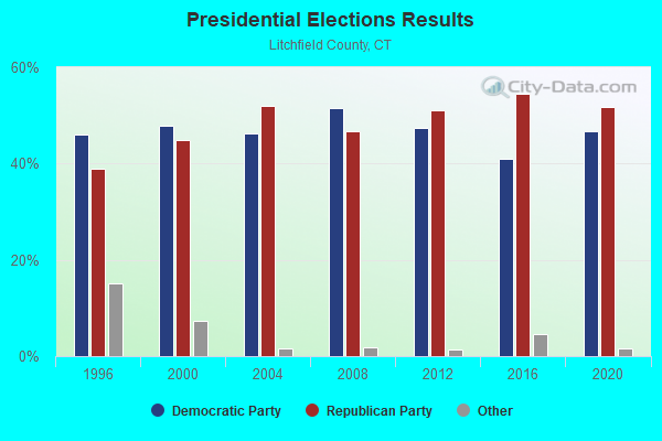
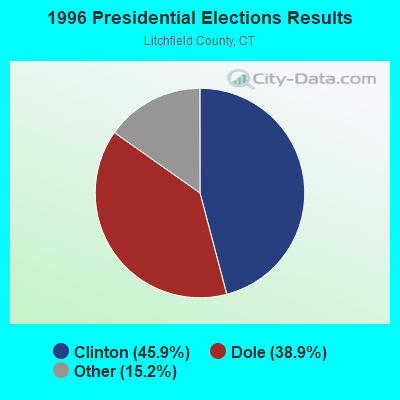
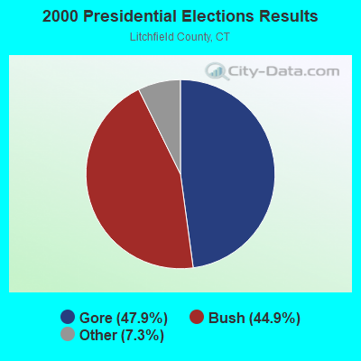
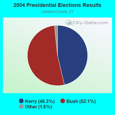
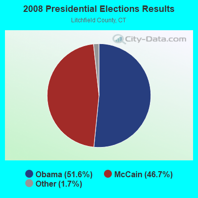
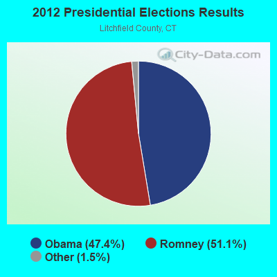
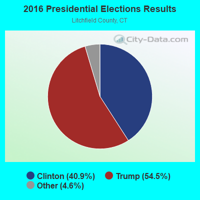
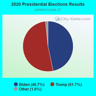
Graphs represent county-level data. Detailed 2008 Election Results
Religion statistics for Bridgewater, CT (based on Litchfield County data)
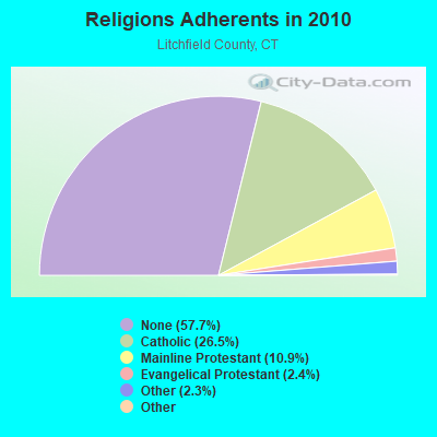
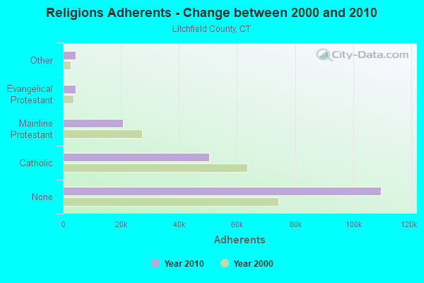
| Religion | Adherents | Congregations |
|---|---|---|
| Catholic | 50,354 | 30 |
| Mainline Protestant | 20,681 | 87 |
| Evangelical Protestant | 4,483 | 39 |
| Other | 4,420 | 16 |
| Orthodox | 175 | 2 |
| Black Protestant | 160 | 2 |
| None | 109,654 | - |
Food Environment Statistics:
| Litchfield County: | 2.29 / 10,000 pop. |
| Connecticut: | 2.21 / 10,000 pop. |
| This county: | 0.05 / 10,000 pop. |
| State: | 0.07 / 10,000 pop. |
| Litchfield County: | 0.64 / 10,000 pop. |
| Connecticut: | 1.02 / 10,000 pop. |
| Litchfield County: | 2.98 / 10,000 pop. |
| State: | 2.27 / 10,000 pop. |
| Here: | 11.07 / 10,000 pop. |
| State: | 9.19 / 10,000 pop. |
| This county: | 6.9% |
| Connecticut: | 7.3% |
| Litchfield County: | 21.1% |
| Connecticut: | 21.5% |
| This county: | 11.8% |
| State: | 15.8% |
Strongest AM radio stations in Bridgewater:
- WTIC (1080 AM; 50 kW; HARTFORD, CT; Owner: INFINITY RADIO OPERATIONS INC.)
- WINE (940 AM; 1 kW; BROOKFIELD, CT; Owner: CUMULUS LICENSING CORP.)
- WFAN (660 AM; 50 kW; NEW YORK, NY; Owner: INFINITY BROADCASTING OPERATIONS, INC.)
- WNNZ (640 AM; 50 kW; WESTFIELD, MA; Owner: CLEAR CHANNEL BROADCASTING LICENSES, INC.)
- WCBS (880 AM; 50 kW; NEW YORK, NY; Owner: INFINITY BROADCASTING OPERATIONS, INC.)
- WABC (770 AM; 50 kW; NEW YORK, NY; Owner: WABC-AM RADIO, INC.)
- WMCA (570 AM; 50 kW; NEW YORK, NY; Owner: SALEM MEDIA OF NEW YORK, LLC)
- WOR (710 AM; 50 kW; NEW YORK, NY; Owner: BUCKLEY BROADCASTING CORPORATION)
- WGSM (740 AM; 25 kW; HUNTINGTON, NY; Owner: K RADIO LICENSEE, INC.)
- WFNW (1380 AM; 5 kW; NAUGATUCK, CT; Owner: CANDIDO DIAS CARRELO)
- WADS (690 AM; daytime; 3 kW; ANSONIA, CT; Owner: RADIO AMOR, INC.)
- WATR (1320 AM; 5 kW; WATERBURY, CT; Owner: WATR, INC.)
- WEPN (1050 AM; 50 kW; NEW YORK, NY; Owner: NEW YORK AM RADIO, LLC)
Strongest FM radio stations in Bridgewater:
- WRKI (95.1 FM; BROOKFIELD, CT; Owner: CUMULUS LICENSING CORP.)
- WDAQ (98.3 FM; DANBURY, CT; Owner: BERKSHIRE BROADCASTING CORP.)
- WDBY (105.5 FM; PATTERSON, NY; Owner: CUMULUS LICENSING CORP.)
- W206AW (89.1 FM; PAWLING, NY; Owner: SOUND OF LIFE, INC.)
- WKCI-FM (101.3 FM; HAMDEN, CT; Owner: CLEAR CHANNEL BROADCASTING LICENSES, INC.)
- WPLR (99.1 FM; NEW HAVEN, CT; Owner: COX RADIO, INC.)
- W218AV (91.5 FM; WARREN, CT; Owner: MONROE BOARD OF EDUCATION)
- WRCH (100.5 FM; NEW BRITAIN, CT; Owner: INFINITY RADIO OPERATIONS INC.)
- WRNQ (92.1 FM; POUGHKEEPSIE, NY; Owner: CLEAR CHANNEL BROADCASTING LICENSES, INC.)
- WPDH (101.5 FM; POUGHKEEPSIE, NY; Owner: CUMULUS LICENSING CORP.)
- WSPK (104.7 FM; POUGHKEEPSIE, NY; Owner: 6 JOHNSON ROAD LICENSES, INC.)
- WEZN-FM (99.9 FM; BRIDGEPORT, CT; Owner: CXR HOLDINGS, INC.)
- WXCI (91.7 FM; DANBURY, CT; Owner: WESTERN CONNECTICUT STATE UNIVERSITY)
- WSHU-FM (91.1 FM; FAIRFIELD, CT; Owner: SACRED HEART UNIVERSITY, INC.)
- WFNP (88.7 FM; ROSENDALE, NY; Owner: STATE UNIVERSITY OF NEW YORK)
- WRHV (88.7 FM; POUGHKEEPSIE, NY; Owner: WMHT EDUCATIONAL TELECOMMUNICATIONS)
- WWYZ (92.5 FM; WATERBURY, CT; Owner: CAPSTAR TX LIMITED PARTNERSHIP)
- WKSS (95.7 FM; HARTFORD-MERIDEN, CT; Owner: CAPSTAR TX LIMITED PARTNERSHIP)
- WRXC (90.1 FM; SHELTON, CT; Owner: MONROE BOARD OF EDUCATION)
- WZMX (93.7 FM; HARTFORD, CT; Owner: INFINITY RADIO OPERATIONS INC.)
TV broadcast stations around Bridgewater:
- WTIC-TV (Channel 61; HARTFORD, CT; Owner: TRIBUNE TELEVISION COMPANY)
- W11BJ (Channel 11; HARTFORD, CT; Owner: COMMUNICATIONS SITE MANAGEMENT LLC)
- WTNH (Channel 8; NEW HAVEN, CT; Owner: WTNH BROADCASTING, INC.)
- WTXX (Channel 20; WATERBURY, CT; Owner: WTXX INC.)
- WCTX (Channel 59; NEW HAVEN, CT; Owner: WTNH BROADCASTING, INC.)
- WEDY (Channel 65; NEW HAVEN, CT; Owner: CONNECTICUT PUBLIC BROADCASTING, INC.)
- WVIT (Channel 30; NEW BRITAIN, CT; Owner: OUTLET BROADCASTING, INC)
- WEDH (Channel 24; HARTFORD, CT; Owner: CONNECTICUT PUBLIC BROADCASTING, INC.)
- WUVN (Channel 18; HARTFORD, CT; Owner: ENTRAVISION HOLDINGS, LLC)
- WEDW (Channel 49; BRIDGEPORT, CT; Owner: CONNECTICUT PUBLIC BROADCASTING, INC.)
- WTBY (Channel 54; POUGHKEEPSIE, NY; Owner: TRINITY BROADCASTING OF NEW YORK, INC.)
- WSAH (Channel 43; BRIDGEPORT, CT; Owner: WSAH LICENSE, INC.)
- W12BH (Channel 12; WATERBURY, CT; Owner: CONN.PUBLIC BROADCASTING, INC.)
- W22BN (Channel 22; DANBURY, CT; Owner: it COMMUNICATIONS, INC.)
- Bridgewater, Connecticut
- Fatal accident count10
- Vehicles involved in fatal accidents17
- Fatal accidents involving drunk persons:2
- Fatalities12
- Persons involved in fatal accidents25
- Pedestrians involved in fatal accidents0
- Connecticut average
- Fatal accident count2479
- Vehicles involved in fatal accidents3677
- Fatal accidents involving drunk persons986
- Fatalities2636
- Persons involved in fatal accidents6059
- Pedestrians involved in fatal accidents426
- National Bridge Inventory (NBI) Statistics
- 2Number of bridges
- 3ft / 1.4mTotal length
- 378Total average daily traffic
- 25Total average daily truck traffic
- 561Total future (year 2038) average daily traffic
FCC Registered Broadcast Land Mobile Towers:
1- 44 S Main St (Lat: 41.534250 Lon: -73.407333), Type: Bant, Structure height: 9.1 m, Overall height: 15 m, Call Sign: KNAB467,
Assigned Frequencies: 159.135 MHz, Grant Date: 09/14/2015, Expiration Date: 11/05/2025, Registrant: Utility Communications, Inc., 920 Sherman Ave, Hamden, CT 06514, Phone: (203) 287-1306, Fax: (203) 248-9167, Email:
FCC Registered Amateur Radio Licenses:
12 (See the full list of FCC Registered Amateur Radio Licenses in Bridgewater)FAA Registered Aircraft:
2- Aircraft: CESSNA T182T (Category: Land, Seats: 4, Weight: Up to 12,499 Pounds), Engine: LYCOMING TIO-540-AK1A (235 HP) (Reciprocating)
N-Number: 233TS, N233TS, N-233TS, Serial Number: T18208523, Year manufactured: 2006, Airworthiness Date: 03/29/2006, Certificate Issue Date: 02/15/2019
Registrant (LLC): Little Sunflower LLC, 98 Benson Rd, Bridgewater, CT 06752 - Aircraft: PITTS SPECIAL S-1C (Category: Land, Weight: Up to 12,499 Pounds, Speed: 108 mph), Engine: LYCOMING 0-290 SERIES (140 HP) (Reciprocating)
N-Number: 3254, N3254, N-3254, Serial Number: 101, Year manufactured: 1964, Airworthiness Date: 05/20/1980, Certificate Issue Date: 01/27/1989
Registrant (Individual): Strother B Purdy, 34 Black Snake Ln, Bridgewater, CT 06752
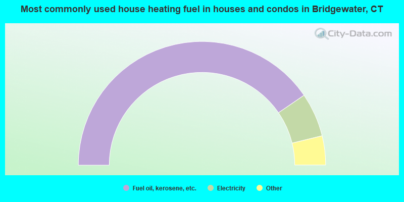
- 80.9%Fuel oil, kerosene, etc.
- 11.5%Electricity
- 3.9%Wood
- 2.5%Bottled, tank, or LP gas
- 0.5%Solar energy
- 0.3%Utility gas
- 0.3%Coal or coke
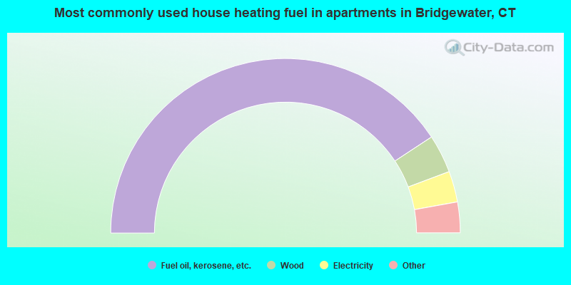
- 81.4%Fuel oil, kerosene, etc.
- 7.1%Wood
- 5.7%Electricity
- 2.9%Utility gas
- 2.9%Bottled, tank, or LP gas
Bridgewater compared to Connecticut state average:
- Median house value above state average.
- Unemployed percentage significantly below state average.
- Black race population percentage significantly below state average.
- Hispanic race population percentage significantly below state average.
- Median age significantly above state average.
- Foreign-born population percentage significantly below state average.
- Renting percentage significantly below state average.
- Length of stay since moving in significantly above state average.
- Number of rooms per house significantly below state average.
- House age significantly below state average.
- Number of college students below state average.
- Percentage of population with a bachelor's degree or higher above state average.
Bridgewater on our top lists:
- #46 on the list of "Top 101 cities with the largest percentage of people in homes or halfway houses for drug/alcohol abuse (population 1,000+)"
- #67 on the list of "Top 101 cities with the largest percentage of people in other workers' dormitories (population 1,000+)"
- #64 (06752) on the list of "Top 101 zip codes with the largest percentage of taxpayers reporting taxable interest in 2012 (pop 1,000+)"
- #7 on the list of "Top 101 counties with the lowest Particulate Matter (PM10) Annual air pollution readings in 2012 (µg/m3)"
- #10 on the list of "Top 101 counties with the lowest number of births per 1000 residents 2007-2013"
- #21 on the list of "Top 101 counties with the largest decrease in the number of births per 1000 residents 2000-2006 to 2007-2013 (pop 50,000+)"
- #38 on the list of "Top 101 counties with the lowest Particulate Matter (PM2.5) Annual air pollution readings in 2012 (µg/m3)"
- #39 on the list of "Top 101 counties with the highest carbon monoxide air pollution readings in 2012 (ppm)"

|
|
Total of 26 patent applications in 2008-2024.