Brookline, New Hampshire

Submit your own pictures of this town and show them to the world
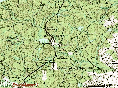
- OSM Map
- General Map
- Google Map
- MSN Map
Population change since 2000: +19.4%
 |
| Males: 2,541 | |
| Females: 2,450 |
| Median resident age: | 39.4 years |
| New Hampshire median age: | 43.9 years |
Zip codes: 03033.
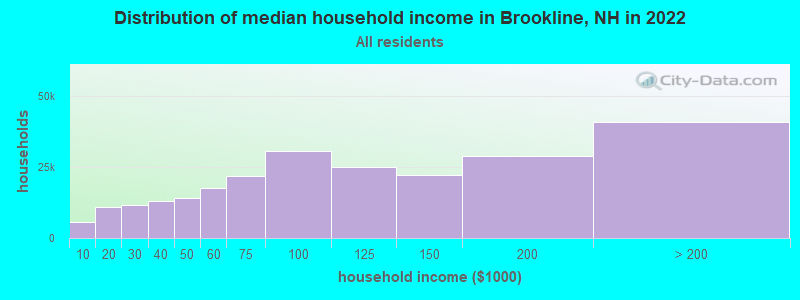
| Brookline: | $139,933 |
| NH: | $89,992 |
Estimated per capita income in 2022: $58,377 (it was $29,272 in 2000)
Brookline town income, earnings, and wages data
Estimated median house or condo value in 2022: $514,863 (it was $171,200 in 2000)
| Brookline: | $514,863 |
| NH: | $384,700 |
Mean prices in 2022: all housing units: $411,252; detached houses: $441,251; townhouses or other attached units: $283,002; in 2-unit structures: $347,377; in 3-to-4-unit structures: $666,663; in 5-or-more-unit structures: $275,798; mobile homes: $132,093
Detailed information about poverty and poor residents in Brookline, NH


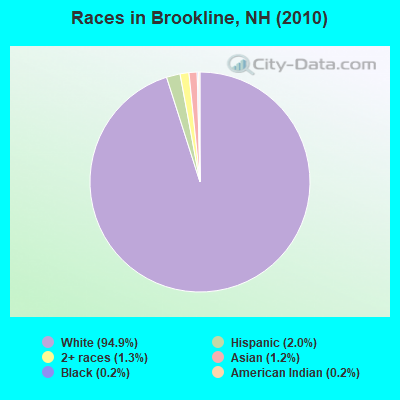
- 4,73894.9%White alone
- 1002.0%Hispanic
- 641.3%Two or more races
- 621.2%Asian alone
- 120.2%Black alone
- 110.2%American Indian alone
- 30.06%Other race alone
- 10.02%Native Hawaiian and Other
Pacific Islander alone
Races in Brookline detailed stats: ancestries, foreign born residents, place of birth
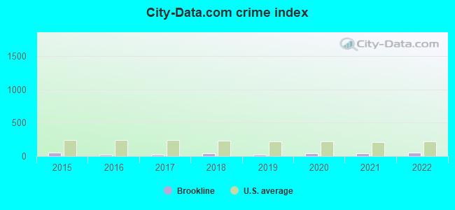
Type |
2015 |
2016 |
2017 |
2018 |
2019 |
2020 |
2021 |
2022 |
|---|---|---|---|---|---|---|---|---|
| Murders (per 100,000) | 0 (0.0) | 0 (0.0) | 0 (0.0) | 0 (0.0) | 0 (0.0) | 0 (0.0) | 0 (0.0) | 0 (0.0) |
| Rapes (per 100,000) | 1 (19.3) | 0 (0.0) | 0 (0.0) | 1 (18.7) | 0 (0.0) | 1 (18.2) | 2 (36.1) | 2 (34.6) |
| Robberies (per 100,000) | 0 (0.0) | 0 (0.0) | 0 (0.0) | 0 (0.0) | 0 (0.0) | 0 (0.0) | 0 (0.0) | 0 (0.0) |
| Assaults (per 100,000) | 3 (57.8) | 2 (38.1) | 3 (56.6) | 5 (93.4) | 1 (18.3) | 4 (72.6) | 0 (0.0) | 1 (17.3) |
| Burglaries (per 100,000) | 7 (134.8) | 3 (57.1) | 4 (75.4) | 3 (56.1) | 2 (36.6) | 1 (18.2) | 2 (36.1) | 5 (86.6) |
| Thefts (per 100,000) | 17 (327.5) | 14 (266.4) | 11 (207.4) | 8 (149.5) | 18 (329.6) | 16 (290.6) | 6 (108.2) | 15 (259.8) |
| Auto thefts (per 100,000) | 2 (38.5) | 1 (19.0) | 0 (0.0) | 1 (18.7) | 2 (36.6) | 3 (54.5) | 1 (18.0) | 3 (52.0) |
| Arson (per 100,000) | 0 (0.0) | 0 (0.0) | 0 (0.0) | 1 (18.7) | 0 (0.0) | 1 (18.2) | 0 (0.0) | 0 (0.0) |
| City-Data.com crime index | 52.6 | 23.8 | 24.9 | 45.0 | 22.3 | 46.3 | 37.1 | 51.8 |
The City-Data.com crime index weighs serious crimes and violent crimes more heavily. Higher means more crime, U.S. average is 246.1. It adjusts for the number of visitors and daily workers commuting into cities.
Crime rate in Brookline detailed stats: murders, rapes, robberies, assaults, burglaries, thefts, arson
Full-time law enforcement employees in 2021, including police officers: 10 (9 officers - 9 male; 0 female).
| Officers per 1,000 residents here: | 1.62 |
| New Hampshire average: | 2.14 |
 Recent articles from our blog. Our writers, many of them Ph.D. graduates or candidates, create easy-to-read articles on a wide variety of topics.

 | Houses to be burned down (17 replies) |
| Brookline and Hollis NH questions (18 replies) |
| Who actually likes living in New Hampshire? ;-) (59 replies) |
| What is Hollis like? (3 replies) |
| Can you recommend a place in NH for a 30 year old single man? (42 replies) |
| Move to Hollis vs. Windham (6 replies) |
Latest news from Brookline, NH collected exclusively by city-data.com from local newspapers, TV, and radio stations
Ancestries: Irish (22.8%), English (19.8%), French (11.8%), German (11.7%), Italian (10.9%), French Canadian (8.7%).
Current Local Time: EST time zone
Incorporated in 1769
Elevation: 249 feet
Land area: 19.8 square miles.
Population density: 252 people per square mile (very low).
143 residents are foreign born (1.5% North America, 1.5% Europe).
| This town: | 3.4% |
| New Hampshire: | 4.4% |
| Brookline town: | 2.4% ($4,194) |
| New Hampshire: | 2.3% ($2,946) |
Nearest city with pop. 50,000+: Nashua, NH  (9.4 miles , pop. 86,605).
Nearest city with pop. 200,000+: Boston, MA (41.4 miles , pop. 589,141).
Nearest city with pop. 1,000,000+: Bronx, NY (173.6 miles , pop. 1,332,650).
Nearest cities:
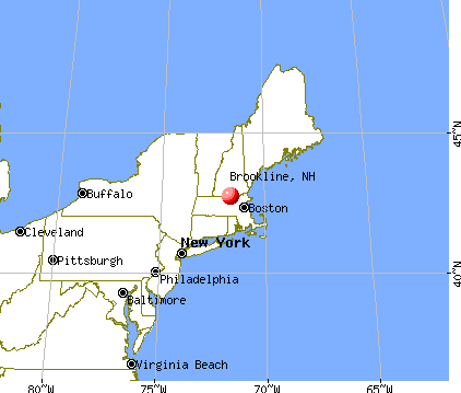
), ), )Latitude: 42.74 N, Longitude: 71.67 W
Area code commonly used in this area: 603

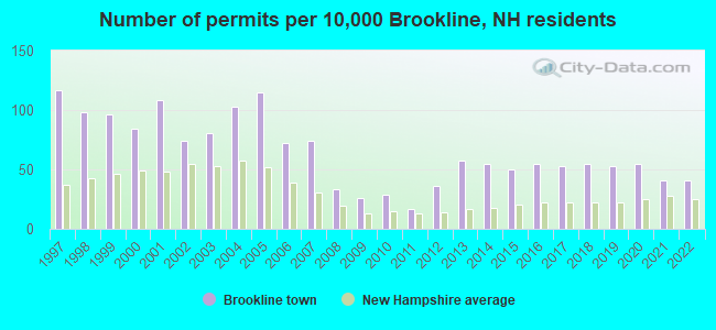
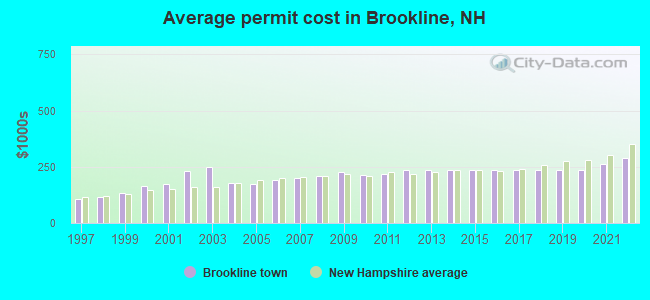
Single-family new house construction building permits:
- 2022: 17 buildings, average cost: $290,200
- 2021: 17 buildings, average cost: $262,500
- 2020: 23 buildings, average cost: $234,200
- 2019: 22 buildings, average cost: $234,200
- 2018: 23 buildings, average cost: $234,200
- 2017: 22 buildings, average cost: $234,200
- 2016: 23 buildings, average cost: $234,200
- 2015: 21 buildings, average cost: $234,200
- 2014: 23 buildings, average cost: $234,200
- 2013: 24 buildings, average cost: $234,200
- 2012: 15 buildings, average cost: $234,500
- 2011: 7 buildings, average cost: $220,300
- 2010: 12 buildings, average cost: $215,300
- 2009: 11 buildings, average cost: $225,300
- 2008: 14 buildings, average cost: $211,400
- 2007: 31 buildings, average cost: $202,100
- 2006: 30 buildings, average cost: $190,300
- 2005: 48 buildings, average cost: $174,000
- 2004: 43 buildings, average cost: $177,500
- 2003: 34 buildings, average cost: $247,100
- 2002: 31 buildings, average cost: $232,700
- 2001: 45 buildings, average cost: $173,600
- 2000: 35 buildings, average cost: $164,700
- 1999: 40 buildings, average cost: $132,000
- 1998: 41 buildings, average cost: $114,500
- 1997: 49 buildings, average cost: $106,900
| Here: | 2.4% |
| New Hampshire: | 2.5% |
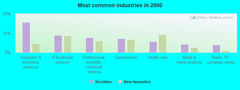
- Computer & electronic products (15.7%)
- Educational services (8.9%)
- Professional, scientific, technical services (7.8%)
- Construction (7.3%)
- Health care (5.8%)
- Metal & metal products (4.4%)
- Radio, TV, computer stores (4.0%)
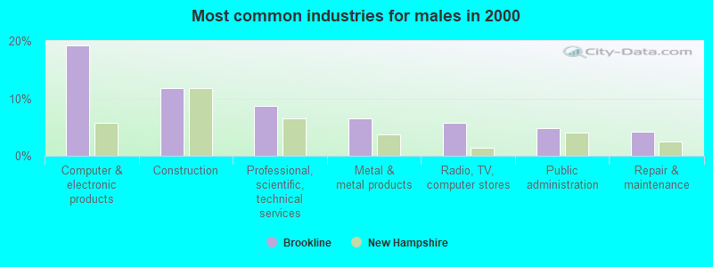
- Computer & electronic products (19.3%)
- Construction (11.7%)
- Professional, scientific, technical services (8.7%)
- Metal & metal products (6.5%)
- Radio, TV, computer stores (5.8%)
- Public administration (4.8%)
- Repair & maintenance (4.3%)
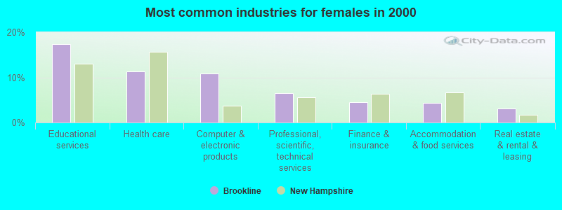
- Educational services (17.3%)
- Health care (11.4%)
- Computer & electronic products (10.8%)
- Professional, scientific, technical services (6.5%)
- Finance & insurance (4.5%)
- Accommodation & food services (4.3%)
- Real estate & rental & leasing (3.1%)
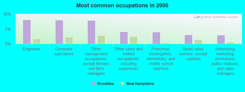
- Engineers (8.2%)
- Computer specialists (8.0%)
- Other management occupations, except farmers and farm managers (8.0%)
- Other sales and related occupations, including supervisors (4.1%)
- Preschool, kindergarten, elementary, and middle school teachers (4.0%)
- Retail sales workers, except cashiers (3.1%)
- Advertising, marketing, promotions, public relations, and sales managers (3.0%)
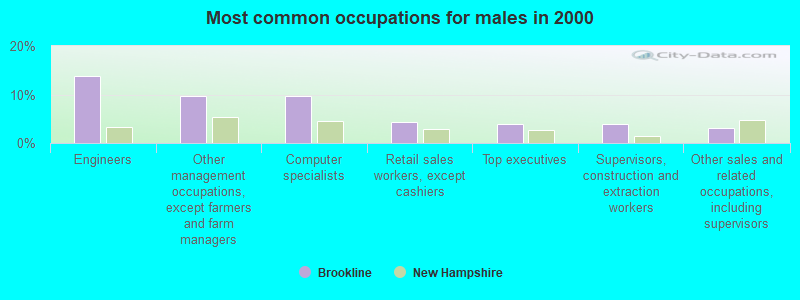
- Engineers (13.7%)
- Other management occupations, except farmers and farm managers (9.7%)
- Computer specialists (9.7%)
- Retail sales workers, except cashiers (4.3%)
- Top executives (4.0%)
- Supervisors, construction and extraction workers (3.9%)
- Other sales and related occupations, including supervisors (3.1%)
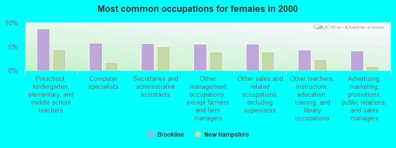
- Preschool, kindergarten, elementary, and middle school teachers (8.7%)
- Computer specialists (5.7%)
- Secretaries and administrative assistants (5.6%)
- Other management occupations, except farmers and farm managers (5.5%)
- Other sales and related occupations, including supervisors (5.5%)
- Other teachers, instructors, education, training, and library occupations (4.3%)
- Advertising, marketing, promotions, public relations, and sales managers (4.1%)
Average climate in Brookline, New Hampshire
Based on data reported by over 4,000 weather stations


(lower is better)
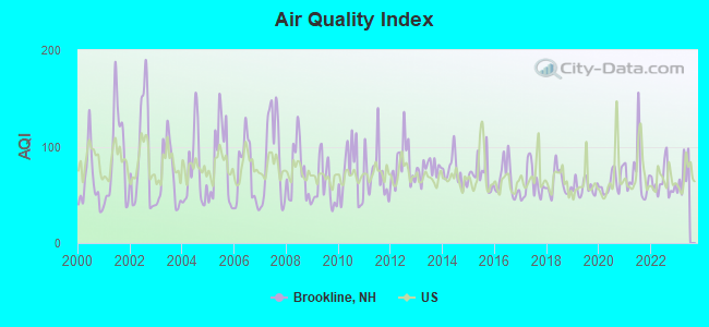
Air Quality Index (AQI) level in 2022 was 62.9. This is about average.
| City: | 62.9 |
| U.S.: | 72.6 |
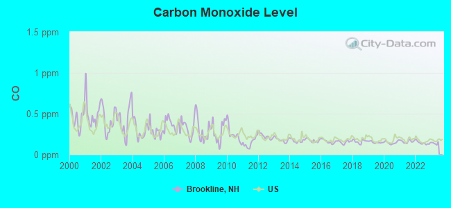
Carbon Monoxide (CO) [ppm] level in 2022 was 0.143. This is significantly better than average. Closest monitor was 10.3 miles away from the city center.
| City: | 0.143 |
| U.S.: | 0.251 |
Nitrogen Dioxide (NO2) [ppb] level in 2022 was 6.77. This is worse than average. Closest monitor was 7.5 miles away from the city center.
| City: | 6.77 |
| U.S.: | 5.11 |
Sulfur Dioxide (SO2) [ppb] level in 2022 was 0.367. This is significantly better than average. Closest monitor was 7.2 miles away from the city center.
| City: | 0.367 |
| U.S.: | 1.515 |
Ozone [ppb] level in 2022 was 29.6. This is about average. Closest monitor was 7.2 miles away from the city center.
| City: | 29.6 |
| U.S.: | 33.3 |
Particulate Matter (PM10) [µg/m3] level in 2022 was 10.6. This is significantly better than average. Closest monitor was 4.0 miles away from the city center.
| City: | 10.6 |
| U.S.: | 19.2 |
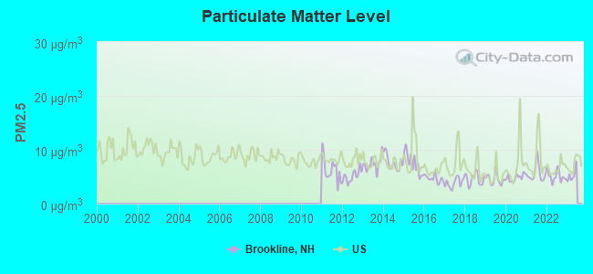
Particulate Matter (PM2.5) [µg/m3] level in 2022 was 5.10. This is significantly better than average. Closest monitor was 10.2 miles away from the city center.
| City: | 5.10 |
| U.S.: | 8.11 |
Tornado activity:
Brookline-area historical tornado activity is above New Hampshire state average. It is 26% smaller than the overall U.S. average.
On 6/9/1953, a category F4 (max. wind speeds 207-260 mph) tornado 31.5 miles away from the Brookline town center killed 90 people and injured 1228 people and caused between $50,000,000 and $500,000,000 in damages.
On 10/3/1970, a category F3 (max. wind speeds 158-206 mph) tornado 14.1 miles away from the town center killed one person and caused between $50,000 and $500,000 in damages.
Earthquake activity:
Brookline-area historical earthquake activity is significantly above New Hampshire state average. It is 71% smaller than the overall U.S. average.On 10/7/1983 at 10:18:46, a magnitude 5.3 (5.1 MB, 5.3 LG, 5.1 ML, Class: Moderate, Intensity: VI - VII) earthquake occurred 158.5 miles away from Brookline center
On 4/20/2002 at 10:50:47, a magnitude 5.3 (5.3 ML, Depth: 3.0 mi) earthquake occurred 159.1 miles away from the city center
On 4/20/2002 at 10:50:47, a magnitude 5.2 (5.2 MB, 4.2 MS, 5.2 MW, 5.0 MW) earthquake occurred 158.5 miles away from Brookline center
On 1/19/1982 at 00:14:42, a magnitude 4.7 (4.5 MB, 4.7 MD, 4.5 LG, Class: Light, Intensity: IV - V) earthquake occurred 52.5 miles away from the city center
On 10/16/2012 at 23:12:25, a magnitude 4.7 (4.7 ML, Depth: 10.0 mi) earthquake occurred 78.0 miles away from Brookline center
On 10/2/1994 at 11:27:22, a magnitude 3.7 (3.5 LG, 3.7 LG, Depth: 6.2 mi, Class: Light, Intensity: II - III) earthquake occurred 41.4 miles away from the city center
Magnitude types: regional Lg-wave magnitude (LG), body-wave magnitude (MB), duration magnitude (MD), local magnitude (ML), surface-wave magnitude (MS), moment magnitude (MW)
Natural disasters:
The number of natural disasters in Hillsborough County (27) is a lot greater than the US average (15).Major Disasters (Presidential) Declared: 17
Emergencies Declared: 10
Causes of natural disasters: Storms: 13, Floods: 11, Winter Storms: 5, Snowstorms: 4, Hurricanes: 3, Snows: 3, Blizzard: 1, Ice Storm: 1, Snowfall: 1, Wind: 1 (Note: some incidents may be assigned to more than one category).
Hospitals and medical centers near Brookline:
- PARK MANOR NURSING HOME (Nursing Home, about 7 miles away; PEPPERELL, MA)
- FREEMAN NURSING HOME (Nursing Home, about 7 miles away; PEPPERELL, MA)
- CRESTWOOD CARE AND REHABILITATION CENTER (Nursing Home, about 7 miles away; MILFORD, NH)
- ELM'S NURSING AND REHAB CENTER (THE) (Nursing Home, about 7 miles away; MILFORD, NH)
- ST JOSEPH HOME AND HOSPICE CARE (Home Health Center, about 7 miles away; MILFORD, NH)
- BEACON HOSPICE INC (Hospital, about 9 miles away; NASHUA, NH)
- ST JOSEPH HOSPITAL Acute Care Hospitals (about 10 miles away; NASHUA, NH)
Airports located in Brookline:
- Brookline Airport (NH16) (Runways: 1)
Colleges/universities with over 2000 students nearest to Brookline:
- Fitchburg State University (about 13 miles; Fitchburg, MA; Full-time enrollment: 5,010)
- University of Massachusetts-Lowell (about 19 miles; Lowell, MA; FT enrollment: 12,341)
- Saint Anselm College (about 19 miles; Manchester, NH; FT enrollment: 2,059)
- Mount Washington College (about 19 miles; Manchester, NH; FT enrollment: 2,187)
- Mount Wachusett Community College (about 20 miles; Gardner, MA; FT enrollment: 3,143)
- Franklin Pierce University (about 21 miles; Rindge, NH; FT enrollment: 2,139)
- Southern New Hampshire University (about 24 miles; Manchester, NH; FT enrollment: 16,552)
Public elementary/middle schools in Brookline:
- RICHARD MAGHAKIAN MEMORIAL SCHOOL (Students: 346, Location: MILFORD ST., Grades: PK-3)
- CAPTAIN SAMUEL DOUGLASS ACADEMY (Students: 277, Location: 24 TOWNSEND HILL RD., Grades: 4-6)
Points of interest:
Notable locations in Brookline: Brookline Ski Area (A), The Stonehouse (B), Brookline Ambulance Service (C), Brookline Public Library (D), Brookline Fire Department (E). Display/hide their locations on the map
Church in Brookline: Church of Christ (A). Display/hide its location on the map
Cemeteries: Lakeview Cemetery (1), Pine Grove Cemetery (2). Display/hide their locations on the map
Lakes, reservoirs, and swamps: Cider Mill Pond (A), Melendy Pond (B), Pierce Pond (C), Pout Pond (D), Talbot Swamp (E), Trout Pond (F), Williams Pond (G), Taylor Pond (H). Display/hide their locations on the map
Streams, rivers, and creeks: Talbot Brook (A), Stonehouse Brook (B), Stickney Brook (C), Spaulding Brook (D), Scab Mill Brook (E), Rocky Pond Brook (F), Wallace Brook (G), Village Brook (H), North Stream (I). Display/hide their locations on the map
| This town: | 3.1 people |
| New Hampshire: | 2.5 people |
| This town: | 84.6% |
| Whole state: | 66.3% |
| This town: | 5.3% |
| Whole state: | 8.3% |
Likely homosexual households (counted as self-reported same-sex unmarried-partner households)
- Lesbian couples: 0.4% of all households
- Gay men: 0.4% of all households
| This town: | 0.8% |
| Whole state: | 6.5% |
| This town: | 0.2% |
| Whole state: | 2.8% |
Banks with branches in Brookline (2011 data):
- TD Bank, National Association: Main Street Branch at Route 13, Gazebo Square, branch established on 1890/01/01. Info updated 2010/10/04: Bank assets: $188,912.6 mil, Deposits: $153,149.8 mil, headquarters in Wilmington, DE, positive income, 1314 total offices, Holding Company: Toronto-Dominion Bank, The
For population 15 years and over in Brookline:
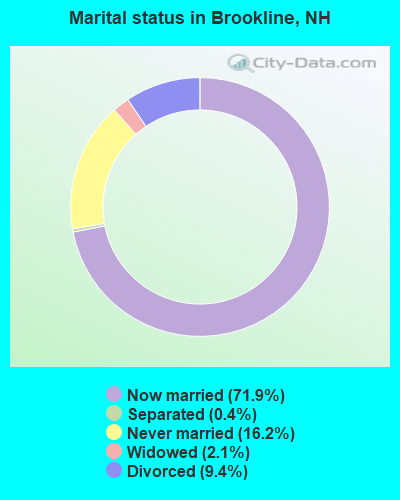
- Never married: 16.2%
- Now married: 71.9%
- Separated: 0.4%
- Widowed: 2.1%
- Divorced: 9.4%
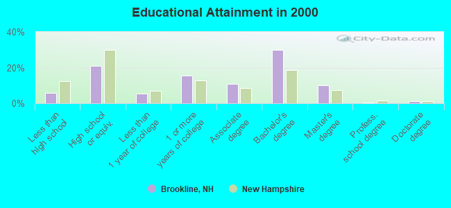
For population 25 years and over in Brookline:
- High school or higher: 94.3%
- Bachelor's degree or higher: 41.8%
- Graduate or professional degree: 11.9%
- Unemployed: 1.6%
- Mean travel time to work (commute): 32.9 minutes
| Here: | 8.7 |
| New Hampshire average: | 10.9 |


Graphs represent county-level data. Detailed 2008 Election Results
Religion statistics for Brookline, NH (based on Hillsborough County data)


| Religion | Adherents | Congregations |
|---|---|---|
| Catholic | 124,993 | 40 |
| Evangelical Protestant | 20,588 | 103 |
| Mainline Protestant | 17,794 | 60 |
| Other | 7,365 | 35 |
| Orthodox | 2,990 | 7 |
| Black Protestant | - | 1 |
| None | 226,991 | - |
Food Environment Statistics:
| Here: | 1.82 / 10,000 pop. |
| State: | 2.14 / 10,000 pop. |
| Hillsborough County: | 0.12 / 10,000 pop. |
| New Hampshire: | 0.15 / 10,000 pop. |
| Hillsborough County: | 1.65 / 10,000 pop. |
| State: | 1.78 / 10,000 pop. |
| Hillsborough County: | 2.67 / 10,000 pop. |
| State: | 4.02 / 10,000 pop. |
| Hillsborough County: | 8.23 / 10,000 pop. |
| New Hampshire: | 9.70 / 10,000 pop. |
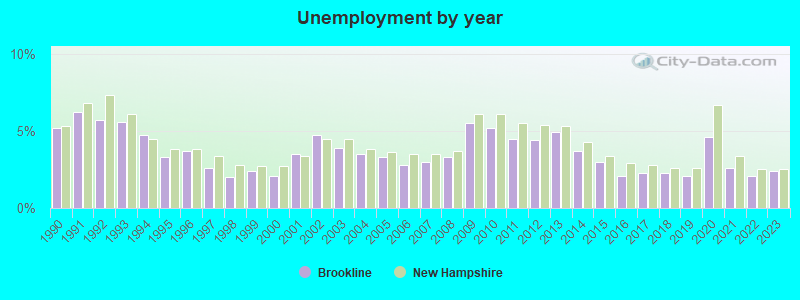
| This county: | 6.9% |
| State: | 7.6% |
| Here: | 24.5% |
| New Hampshire: | 24.4% |
| Here: | 15.1% |
| State: | 15.9% |
6.73% of this county's 2021 resident taxpayers lived in other counties in 2020 ($92,767 average adjusted gross income)
| Here: | 6.73% |
| New Hampshire average: | 7.66% |
0.01% of residents moved from foreign countries ($183 average AGI)
Hillsborough County: 0.01% New Hampshire average: 0.01%
Top counties from which taxpayers relocated into this county between 2020 and 2021:
| from Middlesex County, MA | |
| from Rockingham County, NH | |
| from Merrimack County, NH |
6.49% of this county's 2020 resident taxpayers moved to other counties in 2021 ($81,100 average adjusted gross income)
| Here: | 6.49% |
| New Hampshire average: | 6.80% |
0.02% of residents moved to foreign countries ($105 average AGI)
Hillsborough County: 0.02% New Hampshire average: 0.01%
Top counties to which taxpayers relocated from this county between 2020 and 2021:
| to Rockingham County, NH | |
| to Merrimack County, NH | |
| to Middlesex County, MA |
Businesses in Brookline, NH
- Dunkin Donuts: 1
- Subway: 1
- U-Haul: 1
Strongest AM radio stations in Brookline:
- WRKO (680 AM; 50 kW; BOSTON, MA; Owner: ENTERCOM BOSTON LICENSE, LLC)
- WSMN (1590 AM; 5 kW; NASHUA, NH; Owner: 1590 BROADCASTING CORP.)
- WCRN (830 AM; 50 kW; WORCESTER, MA; Owner: CARTER BROADCASTING CORPORATION)
- WEEI (850 AM; 50 kW; BOSTON, MA; Owner: ENTERCOM BOSTON LICENSE, LLC)
- WKOX (1200 AM; 50 kW; FRAMINGHAM, MA; Owner: CAPSTAR TX LIMITED PARTNERSHIP)
- WBIX (1060 AM; 40 kW; NATICK, MA; Owner: LANGER BROADCASTING CORPORATION)
- WWZN (1510 AM; 50 kW; BOSTON, MA; Owner: ROSE CITY RADIO CORPORATION)
- WEIM (1280 AM; 5 kW; FITCHBURG, MA; Owner: LIVEAIR COMMUNICATIONS, INC.)
- WAMG (890 AM; 25 kW; DEDHAM, MA; Owner: MEGA COMMUNICATIONS OF DEDHAM LICENSEE, LLC)
- WVNE (760 AM; daytime; 25 kW; LEICESTER, MA; Owner: BLOUNT MASSCOM, INC.)
- WCAP (980 AM; 5 kW; LOWELL, MA; Owner: NORTHEAST RADIO, INC.)
- WBZ (1030 AM; 50 kW; BOSTON, MA; Owner: INFINITY BROADCASTING OPERATIONS, INC.)
- WDER (1320 AM; 10 kW; DERRY, NH; Owner: BLOUNT COMMUNICATIONS, INC. OF NH)
Strongest FM radio stations in Brookline:
- WFEX (92.1 FM; PETERBOROUGH, NH; Owner: FNX BROADCASTING OF NEW HAMPSHIRE LLC)
- WGIR-FM (101.1 FM; MANCHESTER, NH; Owner: CAPSTAR TX LIMITED PARTNERSHIP)
- WQLL (96.5 FM; BEDFORD, NH; Owner: SAGA COMMUNICATIONS OF NEW ENGLAND, LLC)
- WLMW (90.7 FM; MANCHESTER, NH; Owner: KNOWLEDGE FOR LIFE)
- WZID (95.7 FM; MANCHESTER, NH; Owner: SAGA COMMUNICATIONS OF NEW ENGLAND, LLC)
- WHOB (106.3 FM; NASHUA, NH; Owner: TELE-MEDIA COMPANY OF NEW HAMPSHIRE, L.L.C.)
- WXLO (104.5 FM; FITCHBURG, MA; Owner: CITADEL BROADCASTING COMPANY)
- WHDQ (106.1 FM; CLAREMONT, NH; Owner: GREAT NORTHERN RADIO, L.L.C.)
- WAAF (107.3 FM; WORCESTER, MA; Owner: ENTERCOM BOSTON LICENSE, LLC)
- WKLB-FM (99.5 FM; LOWELL, MA; Owner: GREATER BOSTON RADIO, INC.)
- WBMX (98.5 FM; BOSTON, MA; Owner: INFINITY RADIO OPERATIONS INC.)
- WJMN (94.5 FM; BOSTON, MA; Owner: AMFM RADIO LICENSES, L.L.C.)
- WCRB (102.5 FM; WALTHAM, MA; Owner: CHARLES RIVER BROADCASTING WCRB LICE)
- WTKK (96.9 FM; BOSTON, MA; Owner: GREATER BOSTON RADIO, INC.)
- WROR-FM (105.7 FM; FRAMINGHAM, MA; Owner: GREATER BOSTON RADIO, INC.)
- WBOS (92.9 FM; BROOKLINE, MA; Owner: GREATER BOSTON RADIO, INC.)
- WVPR (89.5 FM; WINDSOR, VT; Owner: VERMONT PUBLIC RADIO)
- WXKS-FM (107.9 FM; MEDFORD, MA; Owner: AMFM RADIO LICENSES, L.L.C.)
- WINQ (97.7 FM; WINCHENDON, MA; Owner: SAGA COMMUNICATIONS OF NEW ENGLAND, LLC)
- WGBH (89.7 FM; BOSTON, MA; Owner: WGBH EDUCATIONAL FOUNDATION)
TV broadcast stations around Brookline:
- WUTF (Channel 66; MARLBOROUGH, MA; Owner: TELEFUTURA BOSTON LLC)
- WUNI (Channel 27; WORCESTER, MA; Owner: ENTRAVISION HOLDINGS, LLC)
- WNDS (Channel 50; DERRY, NH; Owner: CTV OF DERRY, INC)
- WCVB-TV (Channel 5; BOSTON, MA; Owner: WCVB HEARST-ARGYLE TV, INC.)
- WGBH-TV (Channel 2; BOSTON, MA; Owner: WGBH EDUCATIONAL FOUNDATION)
- WFXZ-CA (Channel 24; BOSTON, MA; Owner: BOSTON BROADCASTING CORP.)
- WHDH-TV (Channel 7; BOSTON, MA; Owner: WHDH-TV)
- WMFP (Channel 62; LAWRENCE, MA; Owner: WSAH LICENSE, INC.)
- WBZ-TV (Channel 4; BOSTON, MA; Owner: VIACOM INC.)
- WGBX-TV (Channel 44; BOSTON, MA; Owner: WGBH EDUCATIONAL FOUNDATION)
- WSBK-TV (Channel 38; BOSTON, MA; Owner: VIACOM INC.)
- WLVI-TV (Channel 56; CAMBRIDGE, MA; Owner: WLVI, INC.)
- WFXT (Channel 25; BOSTON, MA; Owner: FOX TELEVISION STATIONS INC.)
- WBPX (Channel 68; BOSTON, MA; Owner: PAXSON BOSTON-68 LICENSE, INC.)
- W40BO (Channel 40; BOSTON, MA; Owner: PAXSON COMMUNICATIONS LPTV, INC.)
- WTMU-LP (Channel 32; BOSTON, MA; Owner: ZGS BOSTON, INC.)
- W33AK (Channel 33; NASHUA, NH; Owner: CENTER B/CING CORPORATION OF NEW HAMPSHIRE)
- WYCN-LP (Channel 13; NASHUA, NH; Owner: CENTER BROADCASTING CORP. OF NEW HAMPSHIRE)
- WMUR-TV (Channel 9; MANCHESTER, NH; Owner: HEARST-ARGYLE PROPERTIES, INC.)
- National Bridge Inventory (NBI) Statistics
- 8Number of bridges
- 30ft / 8.7mTotal length
- $25,136,000Total costs
- 17,292Total average daily traffic
- 1,028Total average daily truck traffic
- 25,589Total future (year 2042) average daily traffic
FCC Registered Cell Phone Towers:
1 (See the full list of FCC Registered Cell Phone Towers in Brookline)FCC Registered Antenna Towers:
12 (See the full list of FCC Registered Antenna Towers)FCC Registered Broadcast Land Mobile Towers:
1- 29 Ball Hill Rd (Lat: 42.789833 Lon: -71.673417), Type: Gtower, Structure height: 57.9 m, Overall height: 60.6 m, Call Sign: WPPV826,
Assigned Frequencies: 151.070 MHz, Grant Date: 01/13/2015, Expiration Date: 02/03/2025, Certifier: William Bibeau, Registrant: Cara Enterprises Inc., 23 River Road, Gardnerville, NV 89410, Phone: (702) 838-9728, Fax: (603) 431-4832, Email:
FCC Registered Microwave Towers:
4- BROOKLINE, Potanipo Hill Rd (Lat: 42.727222 Lon: -71.672222), Type: Gtower, Structure height: 54.9 m, Overall height: 60.7 m, Call Sign: WPOQ319,
Assigned Frequencies: 6197.24 MHz, Grant Date: 11/20/2018, Expiration Date: 11/06/2028, Certifier: Steven T Campbell, Registrant: Wilkinson Barker Knauer, LLP, 1800 M Street Nw, Suite 800n, Washington, DC 20036, Phone: (202) 383-3420, Fax: (202) 783-5851, Email:
- BROOKLINE NH, 98 Route 13 (Lat: 42.727222 Lon: -71.672222), Type: Gtower, Structure height: 54.9 m, Overall height: 60.7 m, Call Sign: WQRF231,
Assigned Frequencies: 10815.0 MHz, Grant Date: 03/28/2023, Expiration Date: 04/30/2033, Certifier: John E Monday, Registrant: At&t Services, Inc., 208 S Akard St, 20f, Dallas, TX 75202, Phone: (855) 699-7073, Email:
- BOBOS00594A, Atop Potanipo Hill (Lat: 42.727250 Lon: -71.671889), Type: Gtower, Structure height: 54.9 m, Call Sign: WRXX657,
Assigned Frequencies: 10775.0 MHz, 10775.0 MHz, 10775.0 MHz, 10775.0 MHz, 10775.0 MHz, 10775.0 MHz, 10775.0 MHz, 10775.0 MHz, 10775.0 MHz, 10775.0 MHz, 10775.0 MHz, 10775.0 MHz, Grant Date: 07/10/2023, Expiration Date: 07/10/2033, Certifier: Alison A Minea, Registrant: Dish Wireless L.L.C., 9601 S Meridan Blvd, Englewood, CO 80112, Phone: (202) 463-3709, Email:
- BOBOS00594A, Potanipo Hill Rd (Lat: 42.727250 Lon: -71.671889), Type: Ltower, Structure height: 54.9 m, Overall height: 60.7 m, Call Sign: WSAG296,
Assigned Frequencies: 10935.0 MHz, 10935.0 MHz, 10935.0 MHz, 10935.0 MHz, 10935.0 MHz, 10935.0 MHz, 10935.0 MHz, 10935.0 MHz, 10935.0 MHz, 10935.0 MHz, 10935.0 MHz, 10935.0 MHz, Grant Date: 01/16/2024, Expiration Date: 01/16/2034, Certifier: Alison A Minea, Registrant: Dish Wireless L.L.C., 9601 S Meridan Blvd, Englewood, CO 80112, Phone: (202) 463-3709, Email:
FCC Registered Amateur Radio Licenses:
84 (See the full list of FCC Registered Amateur Radio Licenses in Brookline)FAA Registered Aircraft:
24 (See the full list of FAA Registered Aircraft in Brookline)2002 - 2018 National Fire Incident Reporting System (NFIRS) incidents
- Fire incident types reported to NFIRS in Brookline, NH
- 11153.4%Structure Fires
- 6229.8%Outside Fires
- 2512.0%Mobile Property/Vehicle Fires
- 104.8%Other
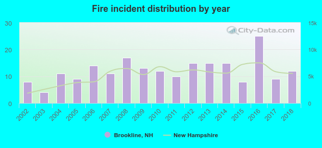 According to the data from the years 2002 - 2018 the average number of fires per year is 12. The highest number of reported fires - 25 took place in 2016, and the least - 4 in 2003. The data has an increasing trend.
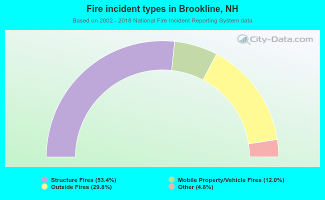 When looking into fire subcategories, the most reports belonged to: Structure Fires (53.4%), and Outside Fires (29.8%).
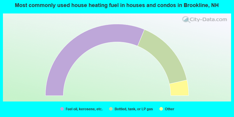
- 62.6%Fuel oil, kerosene, etc.
- 30.5%Bottled, tank, or LP gas
- 3.7%Wood
- 1.8%Electricity
- 1.1%Utility gas
- 0.4%Coal or coke
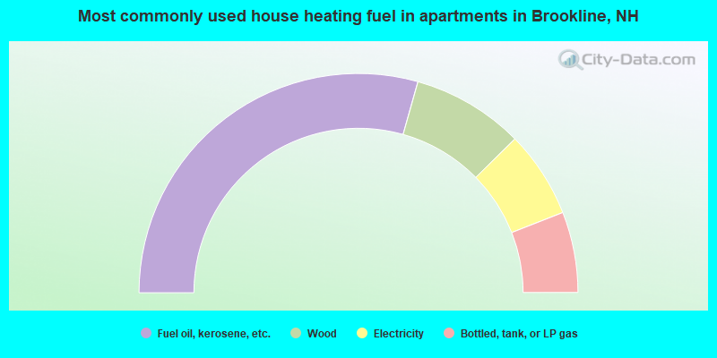
- 58.7%Fuel oil, kerosene, etc.
- 16.5%Wood
- 12.8%Electricity
- 11.9%Bottled, tank, or LP gas
Brookline compared to New Hampshire state average:
- Median household income above state average.
- Unemployed percentage significantly below state average.
- Black race population percentage significantly below state average.
- Hispanic race population percentage below state average.
- Median age below state average.
- Foreign-born population percentage below state average.
- Renting percentage significantly below state average.
- Length of stay since moving in significantly above state average.
- Number of rooms per house significantly below state average.
- House age significantly below state average.

|
|
Total of 257 patent applications in 2008-2024.