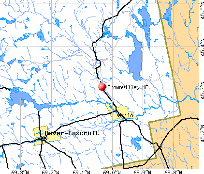
Brownville, Maine
Submit your own pictures of this town and show them to the world
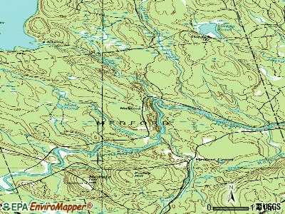
- OSM Map
- General Map
- Google Map
- MSN Map
Population change since 2000: -0.7%
 |
| Males: 660 | |
| Females: 590 |
| Median resident age: | 44.5 years |
| Maine median age: | 43.0 years |
Zip codes: 04414.
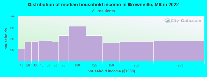
| Brownville: | $52,631 |
| ME: | $69,543 |
Estimated per capita income in 2022: $35,006 (it was $14,774 in 2000)
Brownville town income, earnings, and wages data
Estimated median house or condo value in 2022: $128,472 (it was $49,400 in 2000)
| Brownville: | $128,472 |
| ME: | $290,600 |
Mean prices in 2022: all housing units: $203,844; detached houses: $217,964; townhouses or other attached units: $250,113; in 2-unit structures: $253,343; in 3-to-4-unit structures: $283,591; in 5-or-more-unit structures: $146,783; mobile homes: $82,683
Detailed information about poverty and poor residents in Brownville, ME


- 1,20596.4%White alone
- 161.3%Two or more races
- 161.3%Hispanic
- 80.6%Black alone
- 30.2%American Indian alone
- 20.2%Other race alone
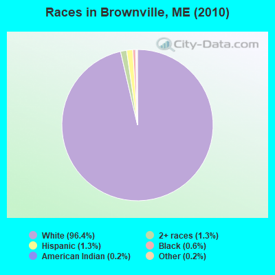
Races in Brownville detailed stats: ancestries, foreign born residents, place of birth
According to our research of Maine and other state lists, there were 3 registered sex offenders living in Brownville, Maine as of May 22, 2024.
The ratio of all residents to sex offenders in Brownville is 417 to 1.
The ratio of registered sex offenders to all residents in this city is near the state average.
 Recent articles from our blog. Our writers, many of them Ph.D. graduates or candidates, create easy-to-read articles on a wide variety of topics.

 | Brownville, Milo area info (4 replies) |
| LePage: "Bring back the guillotine" (90 replies) |
| Bangor to Declare War? (76 replies) |
| The golden road (117 replies) |
| East/West Highway (109 replies) |
| New Brownville Webcam (17 replies) |
Latest news from Brownville, ME collected exclusively by city-data.com from local newspapers, TV, and radio stations
Ancestries: English (31.9%), French (23.2%), Irish (15.0%), United States (8.5%), Scottish (7.9%), Welsh (7.6%).
Current Local Time: EST time zone
Incorporated on 02/03/1824
Elevation: 375 feet
Land area: 44.4 square miles.
Population density: 28 people per square mile (very low).
49 residents are foreign born (3.1% North America, 0.8% Europe).
| This town: | 3.9% |
| Maine: | 2.9% |
| Brownville town: | 1.4% ($689) |
| Maine: | 1.5% ($1,417) |
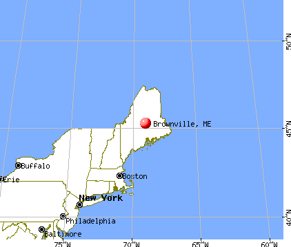
Nearest city with pop. 50,000+: Portland, ME  (131.1 miles , pop. 64,249).
Nearest city with pop. 200,000+: Boston, MA (232.8 miles , pop. 589,141).
Nearest city with pop. 1,000,000+: Bronx, NY (395.4 miles , pop. 1,332,650).
Nearest cities:
), ), )Latitude: 45.35 N, Longitude: 69.04 W
Area code: 207

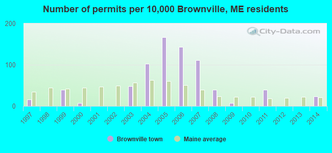
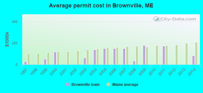
Single-family new house construction building permits:
- 2014: 3 buildings, average cost: $83,300
- 2011: 5 buildings, average cost: $172,800
- 2009: 1 building, cost: $178,900
- 2008: 5 buildings, average cost: $34,500
- 2007: 14 buildings, average cost: $150,200
- 2006: 18 buildings, average cost: $150,200
- 2005: 21 buildings, average cost: $150,200
- 2004: 13 buildings, average cost: $138,800
- 2003: 6 buildings, average cost: $65,000
- 2000: 1 building, cost: $118,000
- 1999: 5 buildings, average cost: $53,000
- 1997: 2 buildings, average cost: $30,000
| Here: | 6.5% |
| Maine: | 3.4% |

- Health care (9.7%)
- Construction (7.3%)
- Educational services (7.1%)
- Leather & allied products (6.9%)
- Paper (6.7%)
- Agriculture, forestry, fishing & hunting (6.1%)
- Food & beverage stores (5.9%)
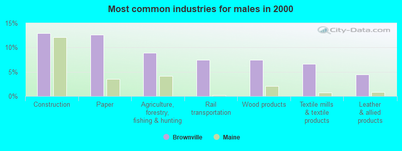
- Construction (13.0%)
- Paper (12.6%)
- Agriculture, forestry, fishing & hunting (8.9%)
- Rail transportation (7.4%)
- Wood products (7.4%)
- Textile mills & textile products (6.7%)
- Leather & allied products (4.4%)
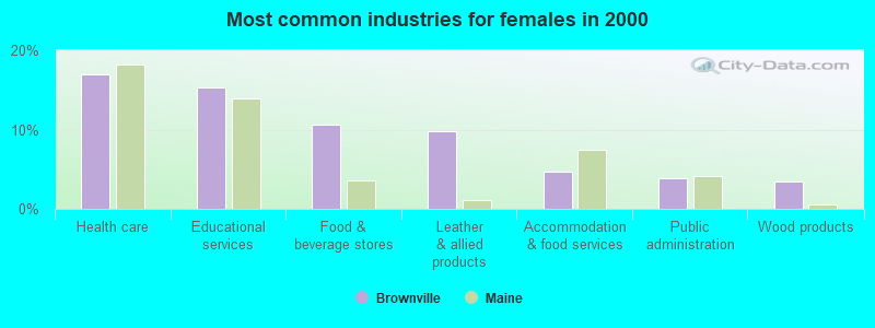
- Health care (17.0%)
- Educational services (15.3%)
- Food & beverage stores (10.6%)
- Leather & allied products (9.8%)
- Accommodation & food services (4.7%)
- Public administration (3.8%)
- Wood products (3.4%)
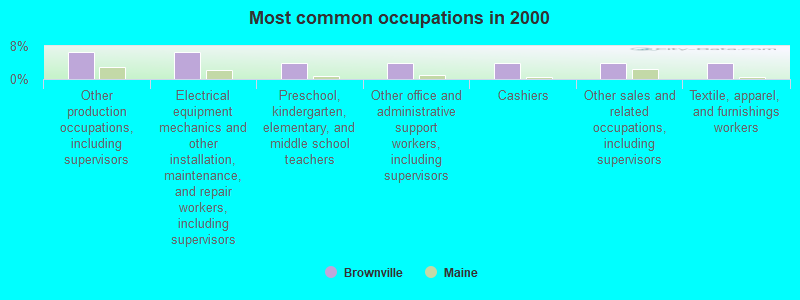
- Other production occupations, including supervisors (6.5%)
- Electrical equipment mechanics and other installation, maintenance, and repair workers, including supervisors (6.5%)
- Preschool, kindergarten, elementary, and middle school teachers (4.0%)
- Other office and administrative support workers, including supervisors (3.8%)
- Cashiers (3.8%)
- Other sales and related occupations, including supervisors (3.8%)
- Textile, apparel, and furnishings workers (3.8%)
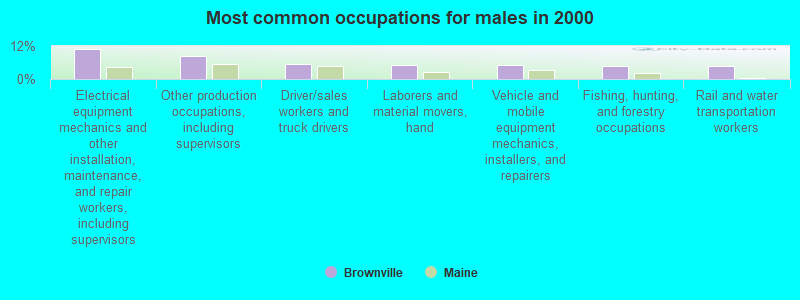
- Electrical equipment mechanics and other installation, maintenance, and repair workers, including supervisors (10.7%)
- Other production occupations, including supervisors (8.5%)
- Driver/sales workers and truck drivers (5.6%)
- Laborers and material movers, hand (5.2%)
- Vehicle and mobile equipment mechanics, installers, and repairers (5.2%)
- Fishing, hunting, and forestry occupations (4.8%)
- Rail and water transportation workers (4.8%)

- Preschool, kindergarten, elementary, and middle school teachers (8.5%)
- Cashiers (6.8%)
- Textile, apparel, and furnishings workers (6.0%)
- Other sales and related occupations, including supervisors (5.1%)
- Other teachers, instructors, education, training, and library occupations (4.7%)
- Secretaries and administrative assistants (4.7%)
- Other production occupations, including supervisors (4.3%)
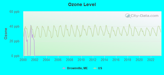
Average climate in Brownville, Maine
Based on data reported by over 4,000 weather stations


Earthquake activity:
Brownville-area historical earthquake activity is significantly above Maine state average. It is 82% smaller than the overall U.S. average.On 4/20/2002 at 10:50:47, a magnitude 5.3 (5.3 ML, Depth: 3.0 mi, Class: Moderate, Intensity: VI - VII) earthquake occurred 235.4 miles away from the city center
On 4/20/2002 at 10:50:47, a magnitude 5.2 (5.2 MB, 4.2 MS, 5.2 MW, 5.0 MW) earthquake occurred 236.8 miles away from Brownville center
On 10/16/2012 at 23:12:25, a magnitude 4.7 (4.7 ML, Depth: 10.0 mi, Class: Light, Intensity: IV - V) earthquake occurred 144.9 miles away from the city center
On 10/7/1983 at 10:18:46, a magnitude 5.3 (5.1 MB, 5.3 LG, 5.1 ML) earthquake occurred 278.2 miles away from Brownville center
On 1/19/1982 at 00:14:42, a magnitude 4.7 (4.5 MB, 4.7 MD, 4.5 LG) earthquake occurred 179.8 miles away from Brownville center
On 2/26/1999 at 03:38:43, a magnitude 3.8 (3.8 LG, Depth: 2.0 mi, Class: Light, Intensity: II - III) earthquake occurred 64.4 miles away from Brownville center
Magnitude types: regional Lg-wave magnitude (LG), body-wave magnitude (MB), duration magnitude (MD), local magnitude (ML), surface-wave magnitude (MS), moment magnitude (MW)
Natural disasters:
The number of natural disasters in Piscataquis County (22) is greater than the US average (15).Major Disasters (Presidential) Declared: 15
Emergencies Declared: 6
Causes of natural disasters: Floods: 13, Storms: 12, Snows: 7, Heavy Rains: 2, Blizzard: 1, Ice Storm: 1, Landslide: 1, Snowfall: 1, Wind: 1, Winter Storm: 1, Other: 2 (Note: some incidents may be assigned to more than one category).
Airports located in Brownville:
- Webber Jones Airport (ME03) (Runways: 1, Itinerant Ops: 50, Local Ops: 160)
Colleges/universities with over 2000 students nearest to Brownville:
- University of Maine (about 36 miles; Orono, ME; Full-time enrollment: 8,931)
- Husson University (about 38 miles; Bangor, ME; FT enrollment: 2,421)
- University of Maine at Farmington (about 72 miles; Farmington, ME; FT enrollment: 2,036)
- University of Maine at Augusta (about 80 miles; Augusta, ME; FT enrollment: 3,204)
- Saint Joseph's College of Maine (about 127 miles; Standish, ME; FT enrollment: 2,010)
- Southern Maine Community College (about 132 miles; South Portland, ME; FT enrollment: 4,666)
- University of Southern Maine (about 132 miles; Portland, ME; FT enrollment: 6,647)
Public elementary/middle school in Brownville:
- BROWNVILLE ELEMENTARY SCHOOL (Students: 117, Location: 774 MAIN ROAD, Grades: KG-5)
Points of interest:
Notable locations in Brownville: Brownville Public Library (A), Junction Fire Station (B), Village Fire Station (C). Display/hide their locations on the map
Cemeteries: Pine Tree Cemetery (1), Village Cemetery (2). Display/hide their locations on the map
Lakes, reservoirs, and swamps: Abbee Pond (A), Jaquith Pond (B), Norton Pond (C), Tannery Pond (D), Pleasant River Reservoir (E), Orson Bog (F). Display/hide their locations on the map
Streams, rivers, and creeks: Sucker Brook (A), West Branch Pleasant River (B), Whetstone Brook (C), Williams Brook (D), Jenks Brook (E), East Branch Pleasant River (F), Middle Branch Pleasant River (G), Mill Brook (H), Mooresville Brook (I). Display/hide their locations on the map
Hotel: Beech Ridge Camps (Schoodic Lake Road) (1). Display/hide its approximate location on the map
Drinking water stations with addresses in Brownville and their reported violations in the past:
WILDWOOD LODGE & REST LLC (Population served: 72, Groundwater):Past health violations:THREE RIVERS M H COMMUNITY (Population served: 63, Groundwater):Past monitoring violations:
- MCL, Monthly (TCR) - In SEP-2011, Contaminant: Coliform. Follow-up actions: St Public Notif requested (OCT-04-2011), St Formal NOV issued (OCT-04-2011), St AO (w/o penalty) issued (APR-18-2012), St Public Notif received (MAY-09-2012), St Compliance achieved (AUG-10-2012)
- MCL, Monthly (TCR) - In AUG-2011, Contaminant: Coliform. Follow-up actions: St Public Notif requested (SEP-13-2011), St Formal NOV issued (SEP-13-2011), St AO (w/o penalty) issued (APR-18-2012), St Public Notif received (MAY-09-2012), St Compliance achieved (AUG-10-2012)
- MCL, Monthly (TCR) - In OCT-2010, Contaminant: Coliform. Follow-up actions: St Public Notif requested (NOV-08-2010), St Formal NOV issued (NOV-08-2010), St Compliance achieved (JUN-01-2011), St AO (w/o penalty) issued (APR-18-2012), St Public Notif received (MAY-09-2012)
- MCL, Monthly (TCR) - In NOV-2009, Contaminant: Coliform. Follow-up actions: St Public Notif requested (DEC-15-2009), St Formal NOV issued (DEC-15-2009), St Compliance achieved (JUN-01-2011), St Intentional no-action (SEP-15-2011), St AO (w/o penalty) issued (APR-18-2012), St Public Notif received (MAY-09-2012)
- MCL, Acute (TCR) - In JUL-2008, Contaminant: Coliform. Follow-up actions: St Tech Assistance Visit (AUG-06-2008), St Boil Water Order (AUG-06-2008), St Formal NOV issued (AUG-06-2008), St Public Notif requested (AUG-06-2008), St Compliance achieved (JUN-01-2011), St Intentional no-action (SEP-15-2011)
- Monitoring, Source Water (GWR) - In JUN-2013, Contaminant: E. COLI. Follow-up actions: St Public Notif requested (AUG-01-2013), St Formal NOV issued (AUG-01-2013), St Compliance achieved (APR-30-2014), St Public Notif received (JUN-05-2014), St Site Visit (enforcement) (JUN-05-2014)
- Monitoring, Repeat Major (TCR) - In MAY-2013, Contaminant: Coliform (TCR). Follow-up actions: St Public Notif requested (JUN-26-2013), St Formal NOV issued (JUN-26-2013), St Compliance achieved (APR-30-2014), St Public Notif received (JUN-05-2014), St Site Visit (enforcement) (JUN-05-2014)
- Monitoring, Repeat Major (TCR) - In DEC-2009, Contaminant: Coliform (TCR). Follow-up actions: St Public Notif requested (DEC-18-2009), St Formal NOV issued (DEC-18-2009), St Compliance achieved (JUN-01-2011), St AO (w/o penalty) issued (APR-18-2012), St Public Notif received (JUN-05-2014), St Site Visit (enforcement) (JUN-05-2014)
- 10 routine major monitoring violations
- One minor monitoring violation
- 2 regular monitoring violations
Past monitoring violations:
- One routine major monitoring violation
Drinking water stations with addresses in Brownville that have no violations reported:
- BROWNVILLE JCT WATER DEPT (Population served: 753, Primary Water Source Type: Groundwater)
- BROWNVILLE WATER DEPARTMENT (Population served: 255, Primary Water Source Type: Groundwater)
| This town: | 2.4 people |
| Maine: | 2.3 people |
| This town: | 65.8% |
| Whole state: | 62.9% |
| This town: | 10.4% |
| Whole state: | 9.4% |
Likely homosexual households (counted as self-reported same-sex unmarried-partner households)
- Lesbian couples: 0.4% of all households
- Gay men: 0.0% of all households
| This town: | 13.6% |
| Whole state: | 10.9% |
| This town: | 6.0% |
| Whole state: | 4.1% |
For population 15 years and over in Brownville:
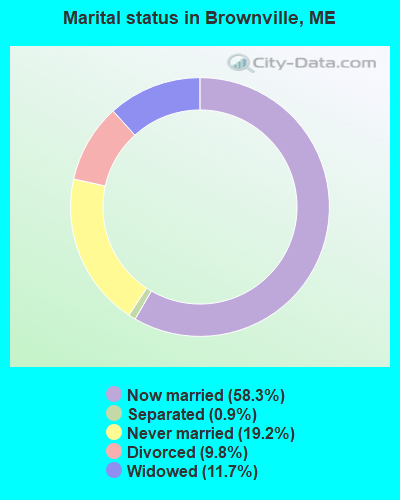
- Never married: 19.2%
- Now married: 58.3%
- Separated: 0.9%
- Widowed: 11.7%
- Divorced: 9.8%
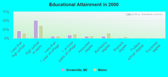
For population 25 years and over in Brownville:
- High school or higher: 79.1%
- Bachelor's degree or higher: 7.2%
- Graduate or professional degree: 1.7%
- Unemployed: 8.2%
- Mean travel time to work (commute): 30.1 minutes
| Here: | 8.8 |
| Maine average: | 11.2 |
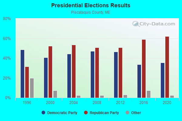
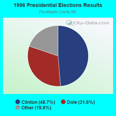
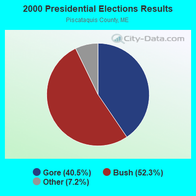

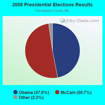
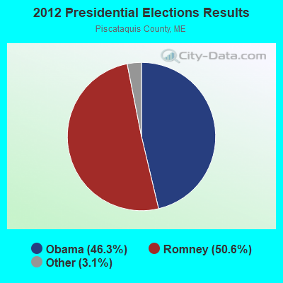


Graphs represent county-level data. Detailed 2008 Election Results
Religion statistics for Brownville, ME (based on Piscataquis County data)
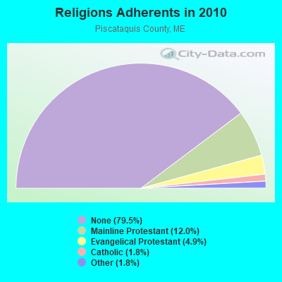
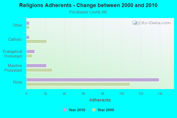
| Religion | Adherents | Congregations |
|---|---|---|
| Mainline Protestant | 2,108 | 13 |
| Evangelical Protestant | 855 | 13 |
| Catholic | 320 | 3 |
| Other | 318 | 5 |
| None | 13,934 | - |
Food Environment Statistics:
| Piscataquis County: | 5.24 / 10,000 pop. |
| State: | 2.80 / 10,000 pop. |
| Piscataquis County: | 4.08 / 10,000 pop. |
| Maine: | 2.20 / 10,000 pop. |
| This county: | 8.74 / 10,000 pop. |
| Maine: | 5.75 / 10,000 pop. |
| This county: | 10.49 / 10,000 pop. |
| Maine: | 11.02 / 10,000 pop. |
| This county: | 8.4% |
| Maine: | 8.2% |
| Piscataquis County: | 27.5% |
| Maine: | 25.0% |
Strongest AM radio stations in Brownville:
- WZON (620 AM; 5 kW; BANGOR, ME; Owner: THE ZONE CORPORATION)
- WSKW (1160 AM; 10 kW; SKOWHEGAN, ME; Owner: MOUNTAIN WIRELESS, INCORPORATED)
- WABI (910 AM; 5 kW; BANGOR, ME; Owner: CLEAR CHANNEL BROADCASTING LICENSES, INC.)
- WTME (780 AM; 10 kW; RUMFORD, ME; Owner: MOUNTAIN VALLEY BROADCASTING, INC.)
- WRKO (680 AM; 50 kW; BOSTON, MA; Owner: ENTERCOM BOSTON LICENSE, LLC)
- WSYY (1240 AM; 1 kW; MILLINOCKET, ME; Owner: KATAHDIN BROADCASTING, INC.)
- WEEI (850 AM; 50 kW; BOSTON, MA; Owner: ENTERCOM BOSTON LICENSE, LLC)
- WCHP (760 AM; 35 kW; CHAMPLAIN, NY; Owner: CHAMPLAIN RADIO, INC.)
- WBZ (1030 AM; 50 kW; BOSTON, MA; Owner: INFINITY BROADCASTING OPERATIONS, INC.)
- WNNZ (640 AM; 50 kW; WESTFIELD, MA; Owner: CLEAR CHANNEL BROADCASTING LICENSES, INC.)
- WCRN (830 AM; 50 kW; WORCESTER, MA; Owner: CARTER BROADCASTING CORPORATION)
- WDEA (1370 AM; 5 kW; ELLSWORTH, ME; Owner: CUMULUS LICENSING CORP.)
- WREM (710 AM; daytime; 5 kW; MONTICELLO, ME; Owner: ALLAN H WEINER)
Strongest FM radio stations in Brownville:
- WVOM (103.9 FM; HOWLAND, ME; Owner: CLEAR CHANNEL BROADCASTING LICENSES, INC.)
- WQCB (106.5 FM; BREWER, ME; Owner: CUMULUS LICENSING CORP.)
- WHCF (88.5 FM; BANGOR, ME; Owner: BANGOR BAPTIST CHURCH)
- WDME-FM (103.1 FM; DOVER-FOXCROFT, ME; Owner: THE ZONE CORPORATION)
- WTOS-FM (105.1 FM; SKOWHEGAN, ME; Owner: CAPSTAR TX LIMITED PARTNERSHIP)
- WGUY (102.1 FM; DEXTER, ME; Owner: CONCORD MEDIA GROUP, INC.)
- WSYY-FM (94.9 FM; MILLINOCKET, ME; Owner: KATAHDIN COMMUNICATIONS, INC.)
- WWBX (97.1 FM; BANGOR, ME; Owner: CLEAR CHANNEL BROADCASTING LICENSES, INC.)
- WBZN (107.3 FM; OLD TOWN, ME; Owner: CUMULUS LICENSING CORP.)
- WHMX (105.7 FM; LINCOLN, ME; Owner: BANGOR BAPTIST CHURCH)
TV broadcast stations around Brownville:
- W27CE (Channel 19; DOVER-FOXCROFT, ME; Owner: TRINITY BROADCASTING NETWORK)
Medal of Honor Recipients
Medal of Honor Recipient born in Brownville: Walter G. Morrill.
Brownville fatal accident list:
Feb 14, 1998 04:19 PM, Vanhorneavenue, Vehicles: 1, Persons: 3, Pedestrians: 1, Fatalities: 1
May 8, 1990 01:30 AM, 11, Vehicles: 1, Persons: 2, Fatalities: 1, Drunk persons involved: 1
May 20, 1987 10:40 PM, 60486049, Vehicles: 2, Persons: 6, Fatalities: 2
- National Bridge Inventory (NBI) Statistics
- 3Number of bridges
- 43ft / 12.8mTotal length
- 3,799Total average daily traffic
- 261Total average daily truck traffic
- 5,254Total future (year 2033) average daily traffic
FCC Registered Cell Phone Towers:
2 (See the full list of FCC Registered Cell Phone Towers in Brownville)FCC Registered Antenna Towers:
27 (See the full list of FCC Registered Antenna Towers)FCC Registered Broadcast Land Mobile Towers:
3- Municipal Bldg Maine St (Lat: 45.306444 Lon: -69.032528), Call Sign: KNDA347,
Assigned Frequencies: 153.920 MHz, Grant Date: 04/24/2002, Expiration Date: 06/08/2012, Cancellation Date: 08/11/2012, Registrant: Town Of Brownville, 586 Main Road, Brownville, ME 04414, Phone: (207) 965-2561, Fax: (207) 965-8768
- Lat: 45.317111 Lon: -69.038333, Call Sign: WRAM733,
Assigned Frequencies: 462.412 MHz, Grant Date: 01/09/2018, Expiration Date: 01/09/2028, Certifier: Kevin Black, Registrant: Cara Enterprises Inc, Las Vegas, NV 89140-0124, Phone: (702) 838-9728, Fax: (702) 363-4607, Email:
- MO - LOC5, Lat: 45.349444 Lon: -69.057250, Call Sign: WRJJ699,
Assigned Frequencies: 161.265 MHz, Grant Date: 09/11/2020, Expiration Date: 09/11/2030, Certifier: Celina Kawasima, Registrant: Canadian Pacific Railway, 5th Floor - 120 South 6th Street, Minneapolis, MN 55402, Phone: (403) 319-6007, Fax: (612) 851-5688, Email:
FCC Registered Microwave Towers:
4- MILO, 2.5 Mi Nw (Lat: 45.315556 Lon: -68.989444), Type: Gtower, Structure height: 68.6 m, Overall height: 76.2 m, Call Sign: WMW569,
Assigned Frequencies: 6256.54 MHz, 6256.54 MHz, 6256.54 MHz, 6256.54 MHz, Grant Date: 03/16/2021, Expiration Date: 02/01/2031, Cancellation Date: 09/20/2023, Registrant: Holland & Knight LLP, 800 17th Street, N.W., Suite #1100, Washington, DC 20006-3906, Phone: (202) 955-3000, Fax: (202) 955-5564, Email:
- BROWNVILLE, Atop Stickney Hill, 3.6 Km East Of Sr-11, 3.37 Km Ne Of (Lat: 45.314722 Lon: -68.985833), Type: Tower, Structure height: 94.4 m, Overall height: 99.1 m, Call Sign: WPJF454,
Assigned Frequencies: 6765.00 MHz, 6835.00 MHz, Grant Date: 02/15/2011, Expiration Date: 02/01/2021, Cancellation Date: 02/20/2014, Certifier: Richard Ekstrand, Registrant: Verizon Wireless, 1120 Sanctuary Pkwy, #150 Gasa5reg, Alpharetta, GA 30009-7630, Phone: (770) 797-1070, Fax: (770) 797-1036, Email:
- Brownville, 447 Stickney Hill (Lat: 45.314528 Lon: -68.987028), Type: Gtower, Structure height: 92.4 m, Overall height: 95.7 m, Call Sign: WQUG363,
Assigned Frequencies: 11225.0 MHz, 11225.0 MHz, 11225.0 MHz, 11225.0 MHz, 11225.0 MHz, 11225.0 MHz, 11225.0 MHz, 11225.0 MHz, 11225.0 MHz, 11305.0 MHz... (+8 more), Grant Date: 06/30/2014, Expiration Date: 06/30/2024, Cancellation Date: 07/24/2020, Certifier: Jessica B Lyons, Registrant: At&t Mobility LLC, 208 S. Akard Street, Room 2100, Dallas, TX 75202, Phone: (855) 699-7073, Email:
- Treadwells, Schoodic Lake Rd (Lat: 45.357750 Lon: -68.982361), Type: Building, Structure height: 8 m, Overall height: 9 m, Call Sign: WQZP526,
Assigned Frequencies: 11645.0 MHz, 11645.0 MHz, 11645.0 MHz, 11645.0 MHz, 11645.0 MHz, 11645.0 MHz, 11645.0 MHz, 11645.0 MHz, 11645.0 MHz, 11645.0 MHz, Grant Date: 06/27/2017, Expiration Date: 06/27/2027, Certifier: Andrew H Hinkley, Registrant: Intelpath, 111 Fuller Rd, Hinsdale, IL 60521, Phone: (312) 841-9188, Email:
FCC Registered Amateur Radio Licenses:
19 (See the full list of FCC Registered Amateur Radio Licenses in Brownville)FAA Registered Aircraft:
3- Aircraft: JERRY L SUKEFORTH /CARROLL E LIL AIRBOSS (Category: Land, Weight: Up to 12,499 Pounds), Engine: HIRTH F-23 (50 HP) (2 Cycle)
N-Number: 1301A, N1301A, N-1301A, Serial Number: LAB01, Year manufactured: 2014, Airworthiness Date: 06/06/2014, Certificate Issue Date: 01/17/2018
Registrant (Individual): George R Dean, 39 Railroad Ave, Brownville, ME 04414 - Aircraft: ENGINEERING & RESEARCH ERCOUPE 415-CD (Category: Land, Seats: 2, Weight: Up to 12,499 Pounds, Speed: 90 mph), Engine: CONT MOTOR A&C75 SERIES (75 HP) (Reciprocating)
N-Number: 3939H, N3939H, N-3939H, Serial Number: 4640, Year manufactured: 1947, Airworthiness Date: 12/19/1955, Certificate Issue Date: 07/07/2014
Registrant (Individual): Joseph R Brooks, 1190 Main Rd, Brownville, ME 04414 - Aircraft: RUDOLPH GARY RUDOLPH ROCKET (Category: Land, Seats: 2, Weight: Up to 12,499 Pounds), Engine: LYCOMING IO-540-C4B5 (250 HP) (Reciprocating)
N-Number: 888GR, N888GR, N-888GR, Serial Number: 3882, Year manufactured: 1996, Airworthiness Date: 04/26/2016, Certificate Issue Date: 07/16/2019
Registrant (Individual): George L Graves, 44 Knights Landing Rd, Brownville, ME 04414
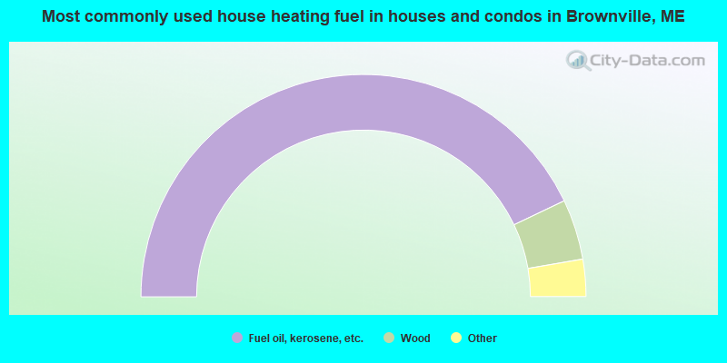
- 85.8%Fuel oil, kerosene, etc.
- 8.8%Wood
- 3.0%Bottled, tank, or LP gas
- 1.9%Electricity
- 0.4%Solar energy
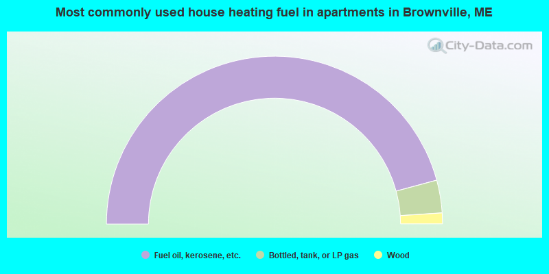
- 91.6%Fuel oil, kerosene, etc.
- 6.3%Bottled, tank, or LP gas
- 2.1%Wood
Brownville compared to Maine state average:
- Median house value significantly below state average.
- Black race population percentage below state average.
- Renting percentage below state average.
- Length of stay since moving in significantly above state average.
- Number of rooms per house significantly below state average.
- House age significantly below state average.
- Number of college students below state average.
- Percentage of population with a bachelor's degree or higher significantly below state average.

|
Total of 2 patent applications in 2008-2024.