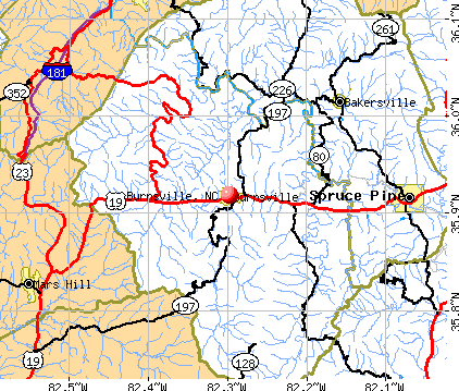
Burnsville, North Carolina
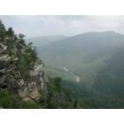
Burnsville: Wisemans View Looking North
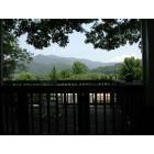
Burnsville: View From Burnsville Porch
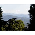
Burnsville: Black Mountains from a deck north of Cherry Lane
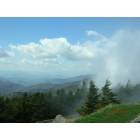
Burnsville: Atop Mount Mitchell, Looking West From the Parking Lot, 5-6-2007
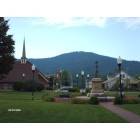
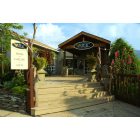
Burnsville: beautiful burnsville town square
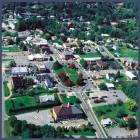
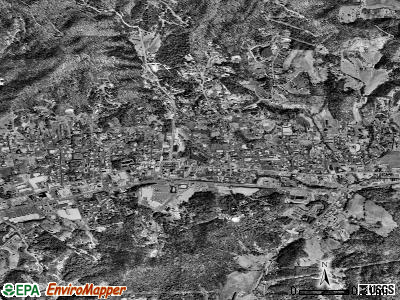
Burnsville: aerial photo of town
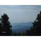
Burnsville: THE BLUE RIDGE MOUNTIANS OF YANCY COUNTY
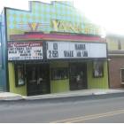
Burnsville: yancey theatre
Burnsville: Great shopping in Burnsville
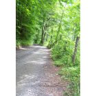
Burnsville: Lickskillet rd
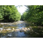
Burnsville: South Toe River
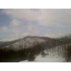
Burnsville: Snow On Mine Branch
- add
your
Submit your own pictures of this town and show them to the world
- OSM Map
- General Map
- Google Map
- MSN Map
Population change since 2000: -0.3%
 |
| Males: 860 | |
| Females: 758 |
| Median resident age: | 37.5 years |
| North Carolina median age: | 39.2 years |
Zip codes: 28714.
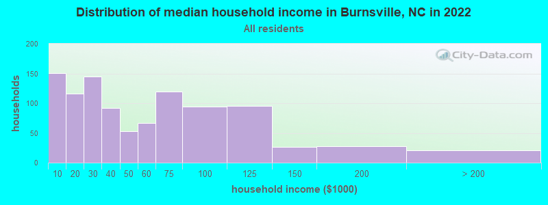
| Burnsville: | $39,781 |
| NC: | $67,481 |
Estimated per capita income in 2022: $28,010 (it was $16,894 in 2000)
Burnsville town income, earnings, and wages data
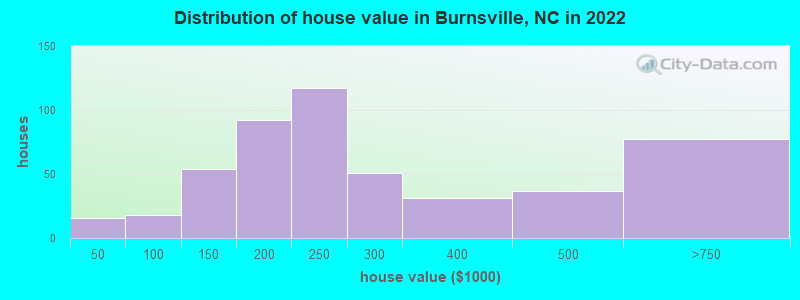
Estimated median house or condo value in 2022: $252,528 (it was $92,700 in 2000)
| Burnsville: | $252,528 |
| NC: | $280,600 |
Mean prices in 2022: all housing units: $305,847; detached houses: $323,267; townhouses or other attached units: $182,129; mobile homes: $13,250
Median gross rent in 2022: $800.
(22.2% for White Non-Hispanic residents, 25.7% for Black residents, 69.2% for Hispanic or Latino residents, 52.0% for other race residents, 76.7% for two or more races residents)
Detailed information about poverty and poor residents in Burnsville, NC


Compare current foreclosures near Burnsville, NC:
| Photo | Address | Area | Beds / Baths | Price | Details |
|---|---|---|---|---|---|

|
#1
Cattail Creek Rd
Burnsville, NC 28714
|
1,500 sq. feet
|
1 baths 3 beds |
show details | |

|
#2
Oak Hill Dr
Burnsville, NC 28714
|
928 sq. feet
|
1 baths 2 beds |
show details | |

|
#3
Look Homeward Dr
Burnsville, NC 28714
|
1,768 sq. feet
|
2 baths 4 beds |
show details | |

|
#4
Rocky Fork Rd
Burnsville, NC 28714
|
824 sq. feet
|
1 baths 2 beds |
show details | |

|
#5
Cold Spring Rd
Burnsville, NC 28714
|
- sq. feet
|
- baths - beds |
show details | |

|
#6
J H Higgins Add
Burnsville, NC 28714
|
- sq. feet
|
- baths - beds |
show details | |

|
#7
Bolens Creek Rd
Burnsville, NC 28714
|
1,448 sq. feet
|
- baths - beds |
show details | |

|
#8
Patsy Creek Rd
Burnsville, NC 28714
|
- sq. feet
|
- baths - beds |
show details | |

|
#9
Us Highway 19w, Apt 5
Burnsville, NC 28714
|
- sq. feet
|
- baths - beds |
show details | |

|
#10
Carolina Ln
Burnsville, NC 28714
|
1,144 sq. feet
|
- baths - beds |
show details |
| Photo | Address | Area | Beds / Baths | Price | Details |
|---|---|---|---|---|---|

|
#11
Abundance Way
Burnsville, NC 28714
|
- sq. feet
|
- baths - beds |
show details | |

|
#12
Lincoln Park Rd
Burnsville, NC 28714
|
- sq. feet
|
- baths - beds |
show details | |

|
#13
Sunset Ln
Burnsville, NC 28714
|
- sq. feet
|
- baths - beds |
show details | |

|
#14
Plum Branch Rd
Burnsville, NC 28714
|
- sq. feet
|
- baths - beds |
show details | |

|
#15
Hwy 19w
Burnsville, NC 28714
|
- sq. feet
|
- baths - beds |
show details | |

|
#16
Cc Allen Rd
Burnsville, NC 28714
|
- sq. feet
|
- baths - beds |
show details | |

|
#17
Catawba St
Erwin, TN 37650
|
1,584 sq. feet
|
2 baths 4 beds |
$305,000
|
show details |

|
#18
Coffee St
Erwin, TN 37650
|
977 sq. feet
|
1 baths 3 beds |
show details | |

|
#19
Jack Sullins Rd
Spruce Pine, NC 28777
|
1,650 sq. feet
|
2 baths 3 beds |
show details | |

|
#20
Love Station Rd
Erwin, TN 37650
|
864 sq. feet
|
1 baths 2 beds |
show details |
| Photo | Address | Area | Beds / Baths | Price | Details |
|---|---|---|---|---|---|

|
#21
Riddle Rd
Barnardsville, NC 28709
|
2,132 sq. feet
|
2 baths 3 beds |
show details | |

|
#22
Almalene Dr
Spruce Pine, NC 28777
|
1,512 sq. feet
|
2 baths 3 beds |
show details | |

|
#23
Dillingham Rd
Barnardsville, NC 28709
|
1,920 sq. feet
|
1 baths 4 beds |
show details | |

|
#24
Holston Ave Apt 2
Erwin, TN 37650
|
- sq. feet
|
- baths - beds |
show details | |

|
#25
Broyles Ave Apt 1a
Erwin, TN 37650
|
- sq. feet
|
- baths - beds |
show details | |

|
#26
Mcinturff Springs Rd
Erwin, TN 37650
|
- sq. feet
|
- baths - beds |
show details | |

|
#27
Bartlett Rd
Weaverville, NC 28787
|
- sq. feet
|
- baths - beds |
show details | |

|
#28
Spar Mill Rd
Erwin, TN 37650
|
- sq. feet
|
- baths - beds |
show details | |

|
#29
Green Meadow Ln
Mars Hill, NC 28754
|
1,512 sq. feet
|
- baths - beds |
show details | |

|
#30
John King Rd
Weaverville, NC 28787
|
636 sq. feet
|
- baths - beds |
show details |
| Photo | Address | Area | Beds / Baths | Price | Details |
|---|---|---|---|---|---|

|
#31
Gay St
Erwin, TN 37650
|
1,305 sq. feet
|
- baths - beds |
show details | |

|
#32
Haw Branch Rd
Barnardsville, NC 28709
|
- sq. feet
|
- baths - beds |
show details | |

|
#33
N Willow Ave
Erwin, TN 37650
|
- sq. feet
|
- baths - beds |
show details | |

|
#34
Granny Shepherd Rd
Mars Hill, NC 28754
|
- sq. feet
|
- baths - beds |
show details | |

|
#35
English Ridge Drive
Mars Hill, NC 28754
|
- sq. feet
|
- baths - beds |
show details | |

|
#36
Laurel Lane
Mars Hill, NC 28754
|
- sq. feet
|
- baths - beds |
show details | |

|
#37
Us 19e
Spruce Pine, NC 28777
|
- sq. feet
|
- baths - beds |
show details | |

|
#38
Chennault Duffer Dr
Spruce Pine, NC 28777
|
- sq. feet
|
- baths - beds |
show details | |

|
#39
Glenaire
Mars Hill, NC 28754
|
- sq. feet
|
- baths - beds |
show details | |

|
#40
Alvins Fox Trail
Mars Hill, NC 28754
|
- sq. feet
|
- baths - beds |
show details |
| Photo | Address | Area | Beds / Baths | Price | Details |
|---|---|---|---|---|---|

|
#41
El Miner Drive
Mars Hill, NC 28754
|
- sq. feet
|
- baths - beds |
show details | |

|
#42
Spring Brook Drive
Mars Hill, NC 28754
|
- sq. feet
|
- baths - beds |
show details | |

|
#43
N Willow Ave
Erwin, TN 37650
|
1,610 sq. feet
|
- baths - beds |
show details | |

|
#44
View Circle
Mars Hill, NC 28754
|
- sq. feet
|
- baths - beds |
show details | |

|
#45
Sandy Lane
Mars Hill, NC 28754
|
- sq. feet
|
- baths - beds |
show details | |

|
#46
Spring Valley Drive
Mars Hill, NC 28754
|
- sq. feet
|
- baths - beds |
show details | |

|
#47
Breakaway Trail South
Mars Hill, NC 28754
|
- sq. feet
|
- baths - beds |
show details | |

|
#48
Foxden Road
Mars Hill, NC 28754
|
- sq. feet
|
- baths - beds |
show details | |

|
#49
Paint Fork Rd
Barnardsville, NC 28709
|
- sq. feet
|
- baths - beds |
show details | |

|
Check over 1 million property listings on Foreclosure.com!
|
browse all offers | |||


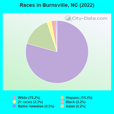
- 1,92579.2%White alone
- 37515.4%Hispanic
- 552.3%Two or more races
- 542.2%Black alone
- 130.5%Native Hawaiian and Other
Pacific Islander alone - 60.2%Asian alone
- 10.04%American Indian alone
Races in Burnsville detailed stats: ancestries, foreign born residents, place of birth
According to our research of North Carolina and other state lists, there were 37 registered sex offenders living in Burnsville, North Carolina as of May 17, 2024.
The ratio of all residents to sex offenders in Burnsville is 46 to 1.
Type |
2009 |
2010 |
2011 |
2012 |
2013 |
2014 |
2016 |
2017 |
2018 |
2019 |
2020 |
2021 |
2022 |
|---|---|---|---|---|---|---|---|---|---|---|---|---|---|
| Murders (per 100,000) | 0 (0.0) | 0 (0.0) | 0 (0.0) | 0 (0.0) | 0 (0.0) | 0 (0.0) | 0 (0.0) | 0 (0.0) | 0 (0.0) | 0 (0.0) | 0 (0.0) | 1 (61.1) | 0 (0.0) |
| Rapes (per 100,000) | 1 (61.0) | 0 (0.0) | 2 (116.7) | 1 (58.8) | 0 (0.0) | 0 (0.0) | 0 (0.0) | 0 (0.0) | 0 (0.0) | 0 (0.0) | 0 (0.0) | 0 (0.0) | 0 (0.0) |
| Robberies (per 100,000) | 0 (0.0) | 1 (59.1) | 1 (58.3) | 1 (58.8) | 0 (0.0) | 0 (0.0) | 0 (0.0) | 0 (0.0) | 0 (0.0) | 0 (0.0) | 0 (0.0) | 0 (0.0) | 0 (0.0) |
| Assaults (per 100,000) | 11 (671.1) | 12 (708.8) | 6 (350.1) | 5 (293.8) | 0 (0.0) | 1 (60.1) | 3 (181.5) | 3 (181.8) | 0 (0.0) | 4 (243.8) | 1 (60.9) | 0 (0.0) | 4 (241.3) |
| Burglaries (per 100,000) | 15 (915.2) | 18 (1,063) | 21 (1,225) | 20 (1,175) | 0 (0.0) | 11 (661.5) | 3 (181.5) | 3 (181.8) | 3 (184.0) | 2 (121.9) | 2 (121.8) | 10 (610.5) | 3 (180.9) |
| Thefts (per 100,000) | 75 (4,576) | 102 (6,025) | 71 (4,142) | 65 (3,819) | 0 (0.0) | 52 (3,127) | 45 (2,722) | 33 (2,000) | 6 (368.1) | 26 (1,584) | 23 (1,401) | 9 (549.5) | 6 (361.9) |
| Auto thefts (per 100,000) | 1 (61.0) | 0 (0.0) | 4 (233.4) | 2 (117.5) | 0 (0.0) | 3 (180.4) | 1 (60.5) | 3 (181.8) | 0 (0.0) | 0 (0.0) | 2 (121.8) | 0 (0.0) | 0 (0.0) |
| Arson (per 100,000) | 0 (0.0) | 0 (0.0) | 0 (0.0) | 0 (0.0) | 0 (0.0) | 0 (0.0) | 0 (0.0) | 0 (0.0) | 0 (0.0) | 0 (0.0) | 0 (0.0) | 0 (0.0) | 0 (0.0) |
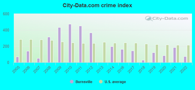
| City-Data.com crime index | 435.0 | 474.9 | 451.0 | 367.8 | 0.0 | 197.8 | 162.7 | 143.6 | 27.6 | 120.7 | 86.5 | 186.8 | 75.4 |
The City-Data.com crime index weighs serious crimes and violent crimes more heavily. Higher means more crime, U.S. average is 246.1. It adjusts for the number of visitors and daily workers commuting into cities.
Crime rate in Burnsville detailed stats: murders, rapes, robberies, assaults, burglaries, thefts, arson
Full-time law enforcement employees in 2021, including police officers: 8 (8 officers - 8 male; 0 female).
| Officers per 1,000 residents here: | 4.88 |
| North Carolina average: | 2.27 |
 Recent articles from our blog. Our writers, many of them Ph.D. graduates or candidates, create easy-to-read articles on a wide variety of topics.


Latest news from Burnsville, NC collected exclusively by city-data.com from local newspapers, TV, and radio stations
Ancestries: American (19.7%), Scotch-Irish (9.1%), English (7.3%), German (6.9%), Irish (4.5%), European (4.4%).
Current Local Time: EST time zone
Elevation: 2814 feet
Land area: 1.58 square miles.
Population density: 1,025 people per square mile (low).
99 residents are foreign born (2.8% Latin America, 0.6% Europe).
| This town: | 4.1% |
| North Carolina: | 8.3% |
Median real estate property taxes paid for housing units with mortgages in 2022: $1,373 (0.6%)
Median real estate property taxes paid for housing units with no mortgage in 2022: $1,868 (0.7%)
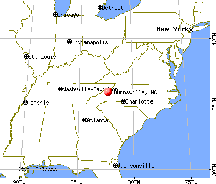
Nearest city with pop. 50,000+: Asheville, NC  (27.5 miles , pop. 68,889).
Nearest city with pop. 200,000+: Charlotte, NC (96.2 miles , pop. 540,828).
Nearest city with pop. 1,000,000+: Philadelphia, PA (481.2 miles , pop. 1,517,550).
Nearest cities:
Latitude: 35.92 N, Longitude: 82.30 W
Daytime population change due to commuting: +1,369 (+56.3%)
Workers who live and work in this town: 360 (39.6%)
Area code: 828
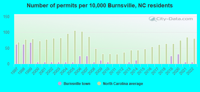
Single-family new house construction building permits:
- 2022: 1 building, cost: $430,000
- 2021: 1 building, cost: $430,000
- 2020: 5 buildings, average cost: $91,000
- 2019: 4 buildings, average cost: $120,000
- 2014: 2 buildings, average cost: $200,000
- 2013: 1 building, cost: $250,000
- 2010: 1 building, cost: $250,000
- 2009: 2 buildings, average cost: $240,000
- 2008: 1 building, cost: $400,000
- 2007: 4 buildings, average cost: $400,000
- 2006: 4 buildings, average cost: $400,000
- 2005: 1 building, cost: $85,000
- 2004: 1 building, cost: $85,000
- 2003: 1 building, cost: $85,000
- 2002: 1 building, cost: $85,000
- 2001: 1 building, cost: $68,000
- 2000: 1 building, cost: $68,000
- 1999: 11 buildings, average cost: $72,200
- 1998: 10 buildings, average cost: $72,200
- 1997: 10 buildings, average cost: $72,200
| Here: | 2.7% |
| North Carolina: | 3.2% |
- Construction (10.3%)
- Educational services (10.3%)
- Health care (9.3%)
- Accommodation & food services (8.2%)
- Professional, scientific, technical services (5.5%)
- Machinery (4.3%)
- Public administration (3.4%)
- Construction (16.7%)
- Educational services (6.0%)
- Professional, scientific, technical services (5.0%)
- Textile mills & textile products (5.0%)
- Machinery (5.0%)
- Health care (5.0%)
- Arts, entertainment, recreation (4.4%)
- Educational services (15.5%)
- Health care (14.4%)
- Accommodation & food services (13.6%)
- Apparel (6.4%)
- Professional, scientific, technical services (6.1%)
- Public administration (4.2%)
- Real estate & rental & leasing (4.2%)
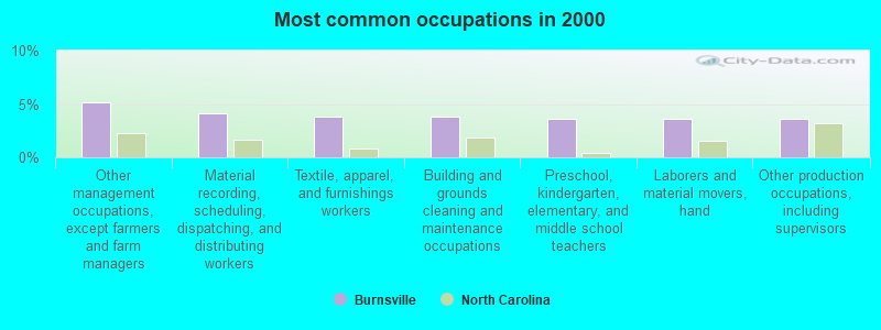
- Other management occupations, except farmers and farm managers (5.2%)
- Material recording, scheduling, dispatching, and distributing workers (4.1%)
- Textile, apparel, and furnishings workers (3.8%)
- Building and grounds cleaning and maintenance occupations (3.8%)
- Preschool, kindergarten, elementary, and middle school teachers (3.6%)
- Laborers and material movers, hand (3.6%)
- Other production occupations, including supervisors (3.6%)
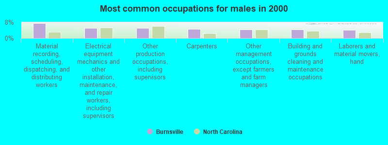
- Material recording, scheduling, dispatching, and distributing workers (7.5%)
- Electrical equipment mechanics and other installation, maintenance, and repair workers, including supervisors (5.0%)
- Other production occupations, including supervisors (5.0%)
- Carpenters (4.7%)
- Other management occupations, except farmers and farm managers (4.4%)
- Building and grounds cleaning and maintenance occupations (4.4%)
- Laborers and material movers, hand (4.1%)
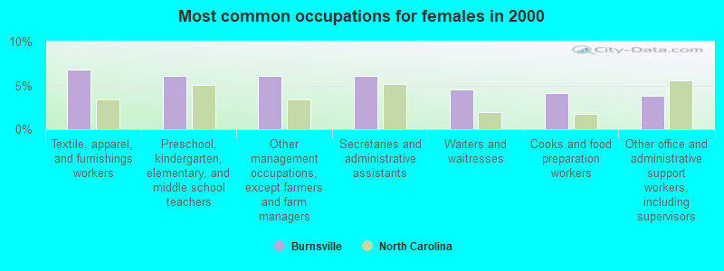
- Textile, apparel, and furnishings workers (6.8%)
- Preschool, kindergarten, elementary, and middle school teachers (6.1%)
- Other management occupations, except farmers and farm managers (6.1%)
- Secretaries and administrative assistants (6.1%)
- Waiters and waitresses (4.5%)
- Cooks and food preparation workers (4.2%)
- Other office and administrative support workers, including supervisors (3.8%)
Average climate in Burnsville, North Carolina
Based on data reported by over 4,000 weather stations


|
|

(lower is better)
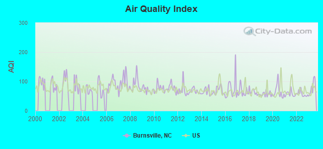
Air Quality Index (AQI) level in 2023 was 78.1. This is about average.
| City: | 78.1 |
| U.S.: | 72.6 |
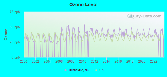
Ozone [ppb] level in 2022 was 35.9. This is about average. Closest monitor was 10.7 miles away from the city center.
| City: | 35.9 |
| U.S.: | 33.3 |
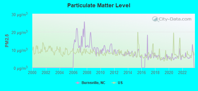
Particulate Matter (PM2.5) [µg/m3] level in 2023 was 7.69. This is about average. Closest monitor was 12.6 miles away from the city center.
| City: | 7.69 |
| U.S.: | 8.11 |
Tornado activity:
Burnsville-area historical tornado activity is below North Carolina state average. It is 52% smaller than the overall U.S. average.
On 7/10/1980, a category F3 (max. wind speeds 158-206 mph) tornado 18.1 miles away from the Burnsville town center injured 12 people and caused between $50,000 and $500,000 in damages.
On 5/5/1989, a category F4 (max. wind speeds 207-260 mph) tornado 50.9 miles away from the town center killed 4 people and injured 52 people and caused between $5,000,000 and $50,000,000 in damages.
Earthquake activity:
Burnsville-area historical earthquake activity is significantly above North Carolina state average. It is 22% greater than the overall U.S. average.On 8/9/2020 at 12:07:37, a magnitude 5.1 (5.1 MW, Depth: 4.7 mi, Class: Moderate, Intensity: VI - VII) earthquake occurred 77.5 miles away from the city center
On 8/23/2011 at 17:51:04, a magnitude 5.8 (5.8 MW, Depth: 3.7 mi) earthquake occurred 277.7 miles away from the city center
On 7/27/1980 at 18:52:21, a magnitude 5.2 (5.1 MB, 4.7 MS, 5.0 UK, 5.2 UK) earthquake occurred 182.4 miles away from the city center
On 11/30/1973 at 07:48:41, a magnitude 4.7 (4.7 MB, 4.6 ML, Class: Light, Intensity: IV - V) earthquake occurred 93.7 miles away from Burnsville center
On 8/2/1974 at 08:52:09, a magnitude 4.9 (4.3 MB, 4.9 LG) earthquake occurred 142.0 miles away from the city center
On 11/23/2006 at 10:42:57, a magnitude 4.3 (4.3 MB) earthquake occurred 87.5 miles away from the city center
Magnitude types: regional Lg-wave magnitude (LG), body-wave magnitude (MB), local magnitude (ML), surface-wave magnitude (MS), moment magnitude (MW)
Natural disasters:
The number of natural disasters in Yancey County (14) is near the US average (15).Major Disasters (Presidential) Declared: 9
Emergencies Declared: 2
Causes of natural disasters: Floods: 7, Storms: 5, Hurricanes: 3, Winter Storms: 2, Blizzard: 1, Landslide: 1, Mudslide: 1, Snowfall: 1, Tornado: 1, Tropical Storm: 1, Wind: 1, Other: 1 (Note: some incidents may be assigned to more than one category).
Hospitals and medical centers in Burnsville:
Other hospitals and medical centers near Burnsville:
- BRIAN CTR HEALTH AND REHAB/SPRUC (Nursing Home, about 12 miles away; SPRUCE PINE, NC)
- THE HOSPICE AND PALLIATIVE CARE CENTER OF MITCHELL C (Hospital, about 14 miles away; SPRUCE PINE, NC)
- MAYLAND DIALYSIS CENTER (Dialysis Facility, about 14 miles away; SPRUCE PINE, NC)
- SPRUCE PINE COMMUNITY HOSPITAL Acute Care Hospitals (about 14 miles away; SPRUCE PINE, NC)
- MADISON HEALTH AND REHABILITATION (Nursing Home, about 15 miles away; MARS HILL, NC)
Airports and heliports located in Burnsville:
See details about Airports and heliports located in Burnsville, NCColleges/universities with over 2000 students nearest to Burnsville:
- University of North Carolina at Asheville (about 26 miles; Asheville, NC; Full-time enrollment: 3,312)
- East Tennessee State University (about 27 miles; Johnson City, TN; FT enrollment: 12,774)
- Asheville-Buncombe Technical Community College (about 29 miles; Asheville, NC; FT enrollment: 6,992)
- Tusculum College (about 32 miles; Greeneville, TN; FT enrollment: 2,070)
- Western Piedmont Community College (about 37 miles; Morganton, NC; FT enrollment: 2,205)
- Northeast State Community College (about 40 miles; Blountville, TN; FT enrollment: 4,480)
- Appalachian State University (about 41 miles; Boone, NC; FT enrollment: 17,362)
Public elementary/middle school in Burnsville:
- BARNARDSVILLE ELEMENTARY (Location: 20 HILLCREST DRIVE, Grades: KG-4)
Points of interest:
Notable locations in Burnsville: Mount Mitchell Boys Camp (A), Toecan Ranger District Office (B). Display/hide their locations on the map
Streams, rivers, and creeks: Mitchell Branch (A), Tantrough Branch (B). Display/hide their locations on the map
Hotels: Carolina Country Inn (600 West Main Street), Colonial Guest Rooms (211 East Main Street), Blue Ridge Motel (204 West Blvd).
Birthplace of: John S. Arrowood - Judge, Ken Holcombe - Baseball player.
Drinking water stations with addresses in Burnsville and their reported violations in the past:
BURNSVILLE, TOWN OF (Population served: 3,802, Surface water):Past health violations:MT MITCHELL STATE PARK (Population served: 2,400, Groundwater):Past monitoring violations:
- OCCT/SOWT Study/Recommendation - In MAR-31-2010, Contaminant: Lead and Copper Rule. Follow-up actions: St Formal NOV issued (APR-14-2010), St Public Notif requested (APR-14-2010), St Compliance achieved (APR-28-2010)
- Public Education - In DEC-01-2009, Contaminant: Lead and Copper Rule. Follow-up actions: St Public Notif requested (APR-21-2010), St Formal NOV issued (APR-21-2010), St Compliance achieved (APR-28-2010)
- Failure Submit IDSE/Subpart V Plan Rpt - In JUL-02-2010, Contaminant: DBP STAGE 2. Follow-up actions: St Compliance achieved (JUN-27-2011)
- Water Quality Parameter M/R - Between APR-2010 and SEP-2010, Contaminant: Lead and Copper Rule. Follow-up actions: St Formal NOV issued (APR-14-2010), St Public Notif requested (APR-14-2010), St Compliance achieved (APR-28-2010), St Public Notif received (FEB-18-2011)
- Initial, Follow-up, or Routine Source Water M/R - In MAR-31-2010, Contaminant: Lead and Copper Rule. Follow-up actions: St Formal NOV issued (APR-14-2010), St Public Notif requested (APR-14-2010), St Compliance achieved (APR-28-2010)
- Follow-up Or Routine LCR Tap M/R - In OCT-01-2007, Contaminant: Lead and Copper Rule. Follow-up actions: St Public Notif requested (MAY-29-2008), St Formal NOV issued (MAY-29-2008), St AO (w/penalty) issued (JUN-26-2008), St Compliance achieved (MAY-21-2012)
- Follow-up Or Routine LCR Tap M/R - In OCT-01-2006, Contaminant: Lead and Copper Rule. Follow-up actions: St Public Notif requested (JAN-18-2007), St Formal NOV issued (JAN-18-2007), St AO (w/penalty) issued (JUN-26-2008), St Public Notif received (JUN-27-2011), St Compliance achieved (MAY-21-2012)
- One minor monitoring violation
- 39 regular monitoring violations
- One other older monitoring violation
Past monitoring violations:TOE RIVER CAMPGROUND (Population served: 185, Groundwater):
- One routine major monitoring violation
Past monitoring violations:MT PLEASANT BAPTIST CHURCH (Population served: 120, Groundwater):
- 6 routine major monitoring violations
- One regular monitoring violation
Past monitoring violations:SOUTH ESTATOE BAPTIST CHURCH (Population served: 80, Groundwater):
- Monitoring, Source Water (GWR) - In FEB-10-2010, Contaminant: E. COLI. Follow-up actions: St Compliance achieved (APR-11-2010), St Public Notif requested (MAY-11-2010), St Formal NOV issued (MAY-11-2010)
- Monitoring, Repeat Major (TCR) - Between JAN-2010 and MAR-2010, Contaminant: Coliform (TCR). Follow-up actions: St Public Notif requested (JUL-08-2010), St Formal NOV issued (JUL-08-2010), St AO (w/penalty) issued (JUL-28-2010), St Case dropped (OCT-08-2010), St Compliance achieved (DEC-31-2010)
- 3 routine major monitoring violations
Past monitoring violations:MT MITCHELL BAPTIST CHURCH (Population served: 50, Groundwater):
- One routine major monitoring violation
Past monitoring violations:HIGH PASTURES (Population served: 50, Groundwater):
- One routine major monitoring violation
Past monitoring violations:WINDOM UNITED METH CHURCH (Population served: 40, Groundwater):
- 2 routine major monitoring violations
- One regular monitoring violation
Past monitoring violations:
- Monitoring, Repeat Major (TCR) - In MAR-2005, Contaminant: Coliform (TCR). Follow-up actions: St Formal NOV issued (MAY-05-2005), St Public Notif requested (MAY-05-2005), St AO (w/penalty) issued (JAN-22-2010), St Compliance achieved (JUN-11-2010), St Intentional no-action (JUN-11-2010)
- 4 routine major monitoring violations
- One regular monitoring violation
Drinking water stations with addresses in Burnsville that have no violations reported:
- HIGGINS FWB CHURCH (Population served: 140, Primary Water Source Type: Groundwater)
- LOW GAP FWB CHURCH (Population served: 65, Primary Water Source Type: Groundwater)
- NORTH BEND FWB CHURCH (Population served: 60, Primary Water Source Type: Groundwater)
- HIGH PASTURES - LAUREL LODGE (Population served: 50, Primary Water Source Type: Groundwater)
| This town: | 2.1 people |
| North Carolina: | 2.5 people |
| This town: | 52.4% |
| Whole state: | 66.7% |
| This town: | 5.0% |
| Whole state: | 5.9% |
Likely homosexual households (counted as self-reported same-sex unmarried-partner households)
- Lesbian couples: 0.1% of all households
- Gay men: 0.5% of all households
People in group quarters in Burnsville in 2010:
- 101 people in nursing facilities/skilled-nursing facilities
- 33 people in local jails and other municipal confinement facilities
- 17 people in other noninstitutional facilities
- 5 people in group homes intended for adults
People in group quarters in Burnsville in 2000:
- 110 people in nursing homes
- 9 people in local jails and other confinement facilities (including police lockups)
- 5 people in homes for the mentally retarded
Banks with branches in Burnsville (2011 data):
- PNC Bank, National Association: West Bypass Branch at 530 West Bypass, branch established on 1988/08/15. Info updated 2012/03/20: Bank assets: $263,309.6 mil, Deposits: $197,343.0 mil, headquarters in Wilmington, DE, positive income, Commercial Lending Specialization, 3085 total offices, Holding Company: Pnc Financial Services Group, Inc., The
- Wells Fargo Bank, National Association: Burnsville Main Branch at 109 Town Square, branch established on 1970/04/20. Info updated 2011/04/05: Bank assets: $1,161,490.0 mil, Deposits: $905,653.0 mil, headquarters in Sioux Falls, SD, positive income, 6395 total offices, Holding Company: Wells Fargo & Company
- First-Citizens Bank & Trust Company: Burnsville Branch at 364 East Bypass, branch established on 1973/01/23. Info updated 2011/10/11: Bank assets: $20,566.4 mil, Deposits: $17,596.8 mil, headquarters in Raleigh, NC, positive income, Commercial Lending Specialization, 433 total offices, Holding Company: First Citizens Bancshares, Inc.
- United Community Bank: Burnsville Branch at 291 East Us Highway 19e, branch established on 2004/02/17. Info updated 2009/06/23: Bank assets: $6,977.4 mil, Deposits: $6,170.1 mil, headquarters in Blairsville, GA, negative income in the last year, Commercial Lending Specialization, 106 total offices, Holding Company: United Community Banks, Inc.
- TD Bank, National Association: Burnsville at 600 West By-Pass, branch established on 1997/12/15. Info updated 2010/10/04: Bank assets: $188,912.6 mil, Deposits: $153,149.8 mil, headquarters in Wilmington, DE, positive income, 1314 total offices, Holding Company: Toronto-Dominion Bank, The
For population 15 years and over in Burnsville:
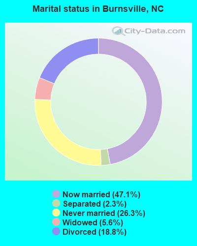
- Never married: 26.3%
- Now married: 47.1%
- Separated: 2.3%
- Widowed: 5.6%
- Divorced: 18.8%
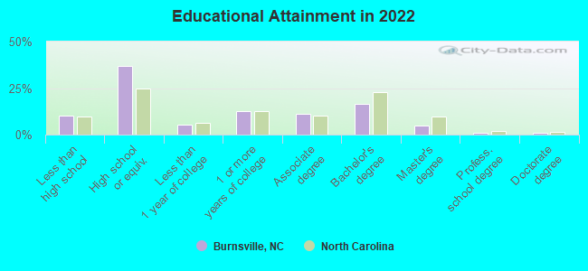
For population 25 years and over in Burnsville:
- High school or higher: 88.6%
- Bachelor's degree or higher: 21.7%
- Graduate or professional degree: 6.7%
- Unemployed: 4.6%
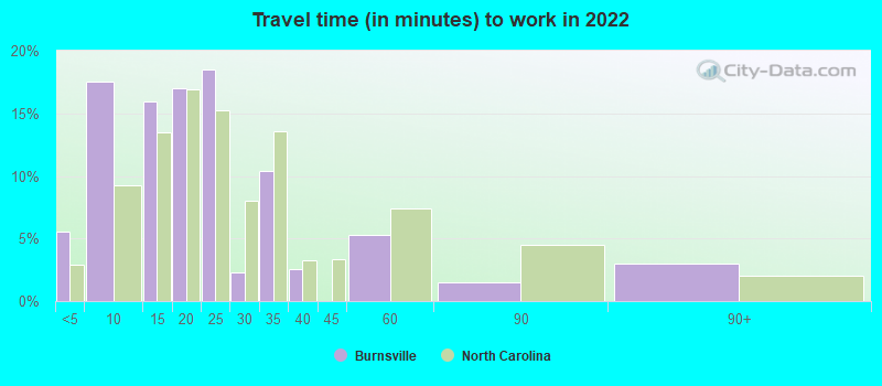
- Mean travel time to work (commute): 20.7 minutes
| Here: | 12.0 |
| North Carolina average: | 11.7 |
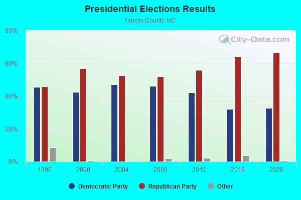
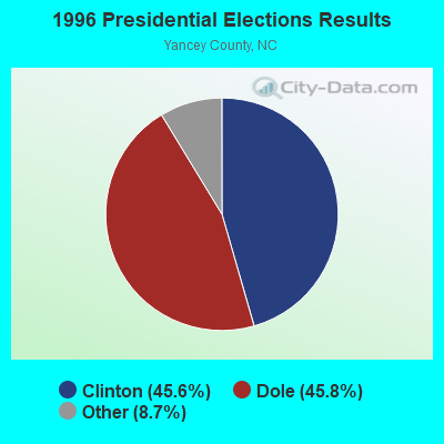
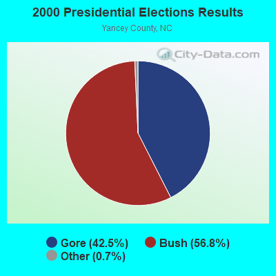
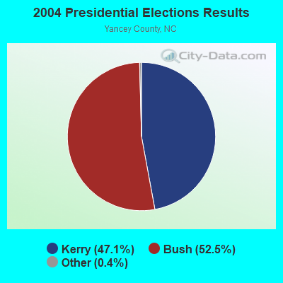
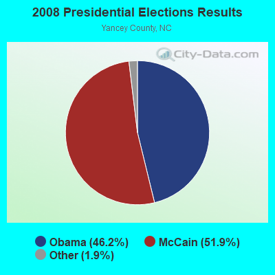
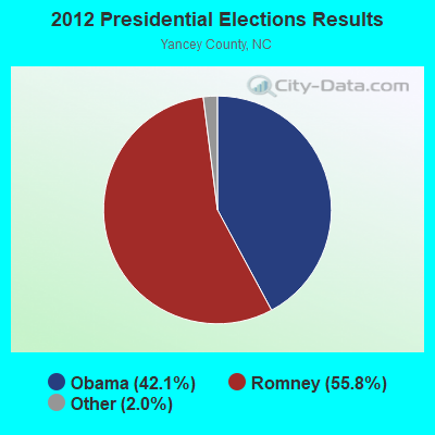
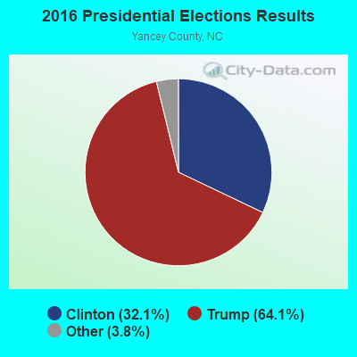
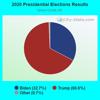
Graphs represent county-level data. Detailed 2008 Election Results
Religion statistics for Burnsville, NC (based on Yancey County data)
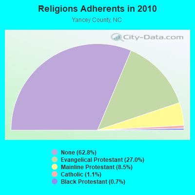
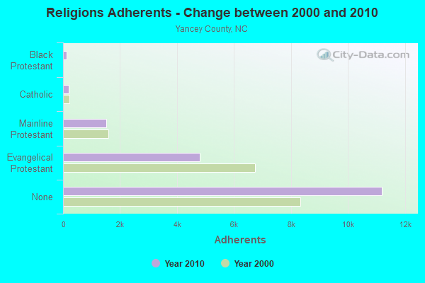
| Religion | Adherents | Congregations |
|---|---|---|
| Evangelical Protestant | 4,808 | 29 |
| Mainline Protestant | 1,512 | 17 |
| Catholic | 190 | 1 |
| Black Protestant | 118 | 1 |
| Other | 9 | 1 |
| None | 11,200 | - |
Food Environment Statistics:
| Yancey County: | 2.72 / 10,000 pop. |
| North Carolina: | 2.05 / 10,000 pop. |
| Here: | 0.54 / 10,000 pop. |
| North Carolina: | 0.92 / 10,000 pop. |
| Here: | 3.26 / 10,000 pop. |
| State: | 4.75 / 10,000 pop. |
| Yancey County: | 3.81 / 10,000 pop. |
| State: | 7.57 / 10,000 pop. |
| Yancey County: | 9.0% |
| North Carolina: | 9.8% |
| Yancey County: | 23.8% |
| North Carolina: | 28.3% |
| Yancey County: | 11.9% |
| State: | 15.6% |
Health and Nutrition:
| Burnsville: | 48.7% |
| North Carolina: | 48.9% |
| Here: | 43.5% |
| State: | 46.1% |
| This city: | 28.4 |
| State: | 28.8 |
| This city: | 21.3% |
| State: | 20.7% |
| Here: | 12.1% |
| North Carolina: | 10.7% |
| Burnsville: | 6.9 |
| State: | 6.8 |
| Here: | 34.2% |
| North Carolina: | 33.7% |
| Burnsville: | 51.8% |
| North Carolina: | 55.8% |
| Here: | 73.7% |
| North Carolina: | 79.7% |
More about Health and Nutrition of Burnsville, NC Residents
| Local government employment and payroll (March 2022) | |||||
| Function | Full-time employees | Monthly full-time payroll | Average yearly full-time wage | Part-time employees | Monthly part-time payroll |
|---|---|---|---|---|---|
| Police Protection - Officers | 11 | $39,634 | $43,237 | 11 | $5,449 |
| Water Supply | 7 | $25,071 | $42,979 | 16 | $36,167 |
| Financial Administration | 2 | $7,820 | $46,920 | 0 | $0 |
| Sewerage | 2 | $8,150 | $48,900 | 16 | $29,345 |
| Other Government Administration | 1 | $5,424 | $65,088 | 20 | $7,008 |
| Firefighters | 1 | $4,106 | $49,272 | 44 | $5,677 |
| Other and Unallocable | 1 | $4,349 | $52,188 | 4 | $4,489 |
| Police - Other | 0 | $0 | 4 | $6,728 | |
| Streets and Highways | 0 | $0 | 44 | $18,870 | |
| Totals for Government | 25 | $94,554 | $45,386 | 159 | $113,733 |
Burnsville government finances - Expenditure in 2017 (per resident):
- Current Operations - Water Utilities: $1,771,000 ($1094.56)
Liquor Stores: $799,000 ($493.82)
Police Protection: $630,000 ($389.37)
Local Fire Protection: $202,000 ($124.85)
Regular Highways: $175,000 ($108.16)
Financial Administration: $151,000 ($93.33)
Parks and Recreation: $126,000 ($77.87)
Solid Waste Management: $114,000 ($70.46)
Central Staff Services: $67,000 ($41.41)
Judicial and Legal Services: $38,000 ($23.49)
Housing and Community Development: $21,000 ($12.98)
Health - Other: $3,000 ($1.85)
Libraries: $3,000 ($1.85)
- Intergovernmental to Local - Other - Health - Other: $3,000 ($1.85)
- Other Capital Outlay - Regular Highways: $107,000 ($66.13)
- Total Salaries and Wages: $205,000 ($126.70)
- Water Utilities - Interest on Debt: $49,000 ($30.28)
Burnsville government finances - Revenue in 2017 (per resident):
- Charges - Sewerage: $840,000 ($519.16)
Parking Facilities: $6,000 ($3.71)
- Local Intergovernmental - Other: $18,000 ($11.12)
- Miscellaneous - Special Assessments: $138,000 ($85.29)
Rents: $57,000 ($35.23)
Fines and Forfeits: $32,000 ($19.78)
General Revenue - Other: $30,000 ($18.54)
Donations From Private Sources: $3,000 ($1.85)
Interest Earnings: $0 ($0.00)
- Revenue - Water Utilities: $1,086,000 ($671.20)
Liquor Stores: $872,000 ($538.94)
- State Intergovernmental - General Local Government Support: $322,000 ($199.01)
Highways: $52,000 ($32.14)
Other: $20,000 ($12.36)
- Tax - Property: $1,013,000 ($626.08)
General Sales and Gross Receipts: $347,000 ($214.46)
Occupation and Business License - Other: $8,000 ($4.94)
Other License: $1,000 ($0.62)
Burnsville government finances - Debt in 2017 (per resident):
- Long Term Debt - Beginning Outstanding - Unspecified Public Purpose: $1,229,000 ($759.58)
Outstanding Unspecified Public Purpose: $1,024,000 ($632.88)
Retired Unspecified Public Purpose: $205,000 ($126.70)
| Businesses in Burnsville, NC | ||||
| Name | Count | Name | Count | |
|---|---|---|---|---|
| Ace Hardware | 1 | MasterBrand Cabinets | 1 | |
| Advance Auto Parts | 1 | McDonald's | 1 | |
| Burger King | 1 | Pizza Hut | 1 | |
| CVS | 1 | RadioShack | 1 | |
| Chevrolet | 1 | Subway | 1 | |
| Decora Cabinetry | 1 | U-Haul | 2 | |
| FedEx | 1 | U.S. Cellular | 1 | |
| H&R Block | 1 | UPS | 1 | |
Strongest AM radio stations in Burnsville:
- WKYK (940 AM; 5 kW; BURNSVILLE, NC; Owner: MARK MEDIA, INC.)
- WFGW (1010 AM; 50 kW; BLACK MOUNTAIN, NC; Owner: BLUE RIDGE BROADCASTING CORP.)
- WTOE (1470 AM; 5 kW; SPRUCE PINE, NC; Owner: MOUNTAIN VALLEY MEDIA, INC.)
- WKJV (1380 AM; 25 kW; ASHEVILLE, NC; Owner: INTERNATIONAL BAPTIST OUTREACH MISSIONS)
- WEMB (1420 AM; 5 kW; ERWIN, TN; Owner: W E M B, INC.)
- WLFJ (660 AM; daytime; 50 kW; GREENVILLE, SC; Owner: CLEAR CHANNEL BROADCASTING LICENSES, INC.)
- WWRN (1350 AM; 10 kW; BLACK MOUNTAIN, NC; Owner: BLACK MOUNTAIN BROADCASTING CORP.)
- WHKY (1290 AM; 50 kW; HICKORY, NC; Owner: LONG COMMUNICATIONS, LLC.)
- WWNC (570 AM; 5 kW; ASHEVILLE, NC; Owner: CAPSTAR TX LIMITED PARTNERSHIP)
- WCSZ (1070 AM; 50 kW; SANS SOUCI, SC; Owner: WHYZ RADIO, L.P.)
- WBRM (1250 AM; 5 kW; MARION, NC; Owner: WBRM, INC.)
- WGOC (640 AM; 10 kW; BLOUNTVILLE, TN; Owner: CITADEL BROADCASTING COMPANY)
- WPWT (870 AM; daytime; 10 kW; COLONIAL HEIGHTS, TN; Owner: INFORMATION COMMUNICATIONS CORP.)
Strongest FM radio stations in Burnsville:
- WMIT (106.9 FM; BLACK MOUNTAIN, NC; Owner: BLUE RIDGE BROADCASTING CORPORATION)
- WNCW (88.7 FM; SPINDALE, NC; Owner: ISOTHERMAL COMMUNITY COLLEGE)
- WQUT (101.5 FM; JOHNSON CITY, TN; Owner: CITADEL BROADCASTING COMPANY)
- WECR-FM (102.3 FM; BEECH MOUNTAIN, NC; Owner: RONDINARO BROADCASTING, INC)
- WPJO (99.3 FM; ELIZABETHTON, TN; Owner: BRISTOL BROADCASTING COMPANY, INC.)
- WHCB (91.5 FM; BRISTOL, TN; Owner: APPALACHIAN EDUC. COMMUNICATION CORP)
- WETS-FM (89.5 FM; JOHNSON CITY, TN; Owner: EAST TENNESSEE STATE UNIVERSITY)
- WXBQ-FM (96.9 FM; BRISTOL, TN; Owner: BRISTOL BROADCASTING COMPANY, INC.)
- WZJS (100.7 FM; BANNER ELK, NC; Owner: HIGHLAND COMMUNICATIONS ASSOCIATES, LLC)
- WKSF (99.9 FM; ASHEVILLE, NC; Owner: CAPSTAR TX LIMITED PARTNERSHIP)
- WQNQ (104.3 FM; OLD FORT, NC; Owner: CLEAR CHANNEL BROADCASTING LICENSES, INC.)
- WCQR-FM (88.3 FM; KINGSPORT, TN; Owner: POSITIVE ALTERNATIVE RADIO, INC.)
- W214AP (90.7 FM; JOHNSON CITY, TN; Owner: THE MOODY BIBLE INSTITUTE OF CHICAGO)
- WAEZ (94.9 FM; GREENEVILLE, TN; Owner: BRISTOL BROADCASTING COMPANY, INC.)
- WTFM (98.5 FM; KINGSPORT, TN; Owner: HOLSTON VALLEY BROADCASTING CORP.)
- WTPT (93.3 FM; FOREST CITY, NC; Owner: UPSTATE BROADCASTING, LLC)
- W220CD (91.9 FM; ENKA, NC; Owner: CALVARY CHAPEL OF TWIN FALLS, INC.)
- WCQS (88.1 FM; ASHEVILLE, NC; Owner: WESTERN NORTH CAROLINA PUBLIC RADIO)
- W237AR (95.3 FM; HAZELWOOD, ETC., NC; Owner: WESTERN NORTH CAROLINA PUBLIC RADIO)
- WQNS (104.9 FM; WAYNESVILLE, NC; Owner: CLEAR CHANNEL BROADCASTING LICENSES, INC.)
TV broadcast stations around Burnsville:
- W67DV (Channel 67; BURNSVILLE, NC; Owner: UNIVERSITY OF NORTH CAROLINA)
- W60CS (Channel 60; BURNSVILLE, NC; Owner: WYFF HEARST-ARGYLE TELEVISION, INC.)
- W02AT (Channel 2; BURNSVILLE, NC; Owner: MEDIA GENERAL BROADCASTING OF SO. CAROLINA HOLDINGS, INC.)
- W12AU (Channel 12; BURNSVILLE, NC; Owner: WLOS LICENSEE, LLC)
- WASV-TV (Channel 62; ASHEVILLE, NC; Owner: MEDIA GENERAL BROADCASTING OF SOUTH CAROLINA HOLDINGS, INC.)
- WCYB-TV (Channel 5; BRISTOL, VA; Owner: APPALACHIAN BROADCASTING CORP.)
- WHNS (Channel 21; ASHEVILLE, NC; Owner: MEREDITH CORPORATION)
- W42AX (Channel 42; BAKERSVILLE, NC; Owner: UNIVERSITY OF NORTH CAROLINA)
- WUNE-TV (Channel 17; LINVILLE, NC; Owner: UNIVERSITY OF NORTH CAROLINA)
- W23BQ (Channel 23; ASHEVILLE, ETC., NC; Owner: CAROLINA CHRISTIAN BROADCASTING, INC.)
- W28AO (Channel 28; SPRUCE PINE, NC; Owner: UNIVERSITY OF NORTH CAROLINA)
- Burnsville, North Carolina
- Fatal accident count10
- Vehicles involved in fatal accidents12
- Fatal accidents involving drunk persons:2
- Fatalities10
- Persons involved in fatal accidents26
- Pedestrians involved in fatal accidents2
- North Carolina average
- Fatal accident count10190
- Vehicles involved in fatal accidents15426
- Fatal accidents involving drunk persons3337
- Fatalities11141
- Persons involved in fatal accidents24484
- Pedestrians involved in fatal accidents1671
- National Bridge Inventory (NBI) Statistics
- 39Number of bridges
- 184ft / 56.2mTotal length
- 70,410Total average daily traffic
- 8,202Total average daily truck traffic
- 140,820Total future (year 2040) average daily traffic
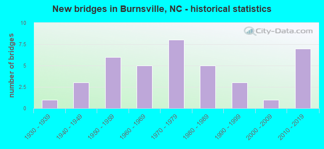
- New bridges - historical statistics
- 11930-1939
- 31940-1949
- 61950-1959
- 51960-1969
- 81970-1979
- 51980-1989
- 31990-1999
- 12000-2009
- 72010-2019
FCC Registered Antenna Towers: 24 (See the full list of FCC Registered Antenna Towers)
FCC Registered Private Land Mobile Towers: 3 (See the full list of FCC Registered Private Land Mobile Towers in Burnsville, NC)
FCC Registered Broadcast Land Mobile Towers: 18 (See the full list of FCC Registered Broadcast Land Mobile Towers)
FCC Registered Microwave Towers: 16 (See the full list of FCC Registered Microwave Towers in this town)
FCC Registered Paging Towers: 1 (See the full list of FCC Registered Paging Towers)
FCC Registered Maritime Coast & Aviation Ground Towers: 1 (See the full list of FCC Registered Maritime Coast & Aviation Ground Towers)
FCC Registered Amateur Radio Licenses: 188 (See the full list of FCC Registered Amateur Radio Licenses in Burnsville)
FAA Registered Aircraft Manufacturers and Dealers: 1 (See the full list of FAA Registered Manufacturers and Dealers in Burnsville)
FAA Registered Aircraft: 12 (See the full list of FAA Registered Aircraft)
2002 - 2018 National Fire Incident Reporting System (NFIRS) incidents
- Fire incident types reported to NFIRS in Burnsville, NC
- 78057.9%Structure Fires
- 34825.9%Outside Fires
- 1118.2%Mobile Property/Vehicle Fires
- 1077.9%Other
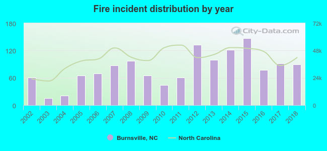 According to the data from the years 2002 - 2018 the average number of fire incidents per year is 79. The highest number of fires - 147 took place in 2015, and the least - 16 in 2003. The data has a rising trend.
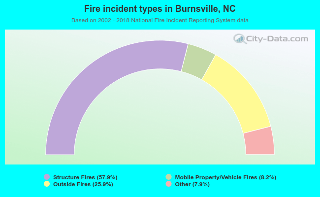 When looking into fire subcategories, the most incidents belonged to: Structure Fires (57.9%), and Outside Fires (25.9%).
| Most common first names in Burnsville, NC among deceased individuals | ||
| Name | Count | Lived (average) |
|---|---|---|
| John | 109 | 77.8 years |
| William | 98 | 76.6 years |
| Mary | 98 | 74.7 years |
| James | 94 | 74.5 years |
| Charles | 59 | 73.9 years |
| Robert | 51 | 74.5 years |
| George | 40 | 77.8 years |
| Martha | 35 | 82.4 years |
| Roy | 32 | 75.3 years |
| Fred | 30 | 78.1 years |
| Most common last names in Burnsville, NC among deceased individuals | ||
| Last name | Count | Lived (average) |
|---|---|---|
| Hensley | 130 | 78.2 years |
| Wilson | 120 | 75.9 years |
| Edwards | 98 | 77.1 years |
| Robinson | 92 | 77.7 years |
| Ray | 87 | 78.4 years |
| Young | 77 | 79.5 years |
| Boone | 57 | 77.0 years |
| Higgins | 56 | 80.1 years |
| Fox | 55 | 74.3 years |
| Mcintosh | 54 | 82.2 years |
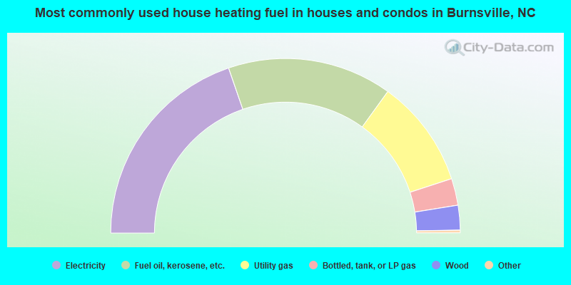
- 39.6%Electricity
- 30.6%Fuel oil, kerosene, etc.
- 20.1%Utility gas
- 5.0%Bottled, tank, or LP gas
- 4.6%Wood
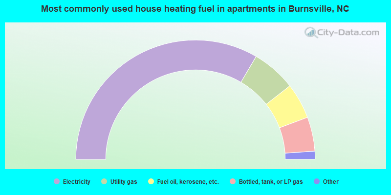
- 67.2%Electricity
- 12.0%Utility gas
- 9.7%Fuel oil, kerosene, etc.
- 9.3%Bottled, tank, or LP gas
- 1.1%No fuel used
- 0.8%Wood
Burnsville compared to North Carolina state average:
- Median household income below state average.
- Unemployed percentage significantly below state average.
- Black race population percentage significantly below state average.
- Hispanic race population percentage above state average.
- Renting percentage above state average.
- Length of stay since moving in above state average.
- Number of rooms per house below state average.
- House age above state average.
- Institutionalized population percentage significantly above state average.

|
|
Total of 17 patent applications in 2008-2024.