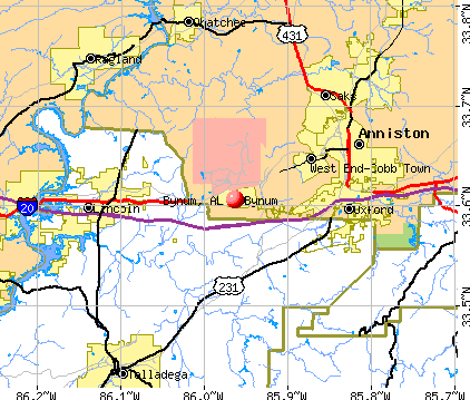
Bynum, Alabama
Submit your own pictures of this place and show them to the world
- OSM Map
- General Map
- Google Map
- MSN Map
| Males: 919 | |
| Females: 968 |
| Median resident age: | 36.7 years |
| Alabama median age: | 35.8 years |
Zip codes: 36260.
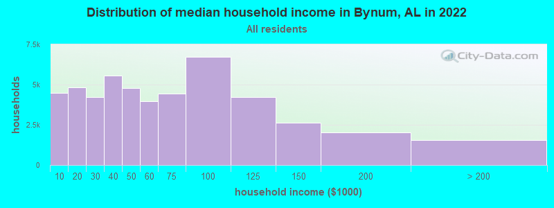
| Bynum: | $57,154 |
| AL: | $59,674 |
Estimated per capita income in 2022: $28,415 (it was $17,194 in 2000)
Bynum CDP income, earnings, and wages data
Estimated median house or condo value in 2022: $144,042 (it was $63,900 in 2000)
| Bynum: | $144,042 |
| AL: | $200,900 |
Mean prices in 2022: all housing units: $179,839; detached houses: $196,415; townhouses or other attached units: $146,744; in 2-unit structures: $123,694; in 3-to-4-unit structures: $156,596; in 5-or-more-unit structures: $109,149; mobile homes: $67,628; occupied boats, rvs, vans, etc.: $20,651
Detailed information about poverty and poor residents in Bynum, AL


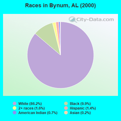
- 1,60686.2%White alone
- 1849.9%Black alone
- 301.6%Two or more races
- 261.4%Hispanic
- 130.7%American Indian alone
- 30.2%Asian alone
- 10.05%Other race alone
 Recent articles from our blog. Our writers, many of them Ph.D. graduates or candidates, create easy-to-read articles on a wide variety of topics.


 | Minimum lot = 60 feet wide (10 replies) |
Latest news from Bynum, AL collected exclusively by city-data.com from local newspapers, TV, and radio stations
Ancestries: United States (30.5%), Irish (9.9%), German (8.6%), English (4.3%), Welsh (2.6%), Scotch-Irish (2.1%).
Current Local Time: CST time zone
Elevation: 620 feet
Land area: 3.30 square miles.
Population density: 572 people per square mile (low).
7 residents are foreign born
| This place: | 0.4% |
| Alabama: | 2.0% |
| Bynum CDP: | 0.3% ($199) |
| Alabama: | 0.4% ($289) |
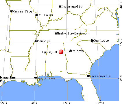
Nearest city with pop. 50,000+: Birmingham, AL  (49.3 miles , pop. 242,820).
Nearest city with pop. 1,000,000+: Chicago, IL (577.2 miles , pop. 2,896,016).
Nearest cities:
), ), ), ), ), Latitude: 33.61 N, Longitude: 85.96 W
Area code commonly used in this area: 256

| Here: | 2.9% |
| Alabama: | 2.6% |
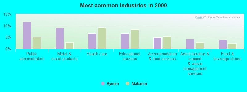
- Public administration (11.6%)
- Metal & metal products (9.2%)
- Health care (6.6%)
- Educational services (6.6%)
- Accommodation & food services (4.9%)
- Administrative & support & waste management services (4.2%)
- Food & beverage stores (4.0%)
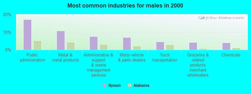
- Public administration (17.2%)
- Metal & metal products (10.8%)
- Administrative & support & waste management services (7.6%)
- Motor vehicle & parts dealers (7.0%)
- Truck transportation (4.7%)
- Groceries & related products merchant wholesalers (4.2%)
- Chemicals (4.0%)
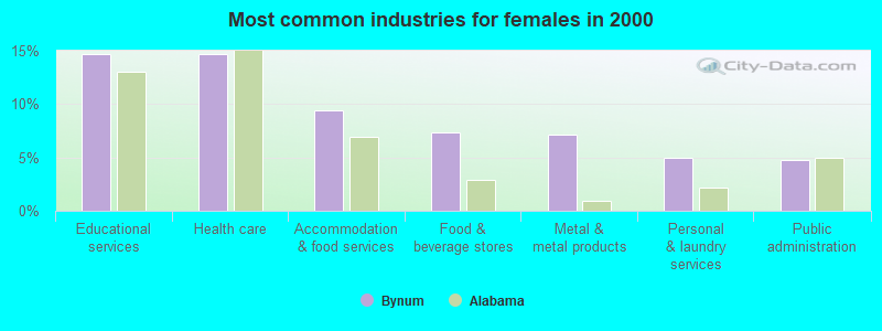
- Educational services (14.7%)
- Health care (14.7%)
- Accommodation & food services (9.4%)
- Food & beverage stores (7.3%)
- Metal & metal products (7.1%)
- Personal & laundry services (5.0%)
- Public administration (4.7%)
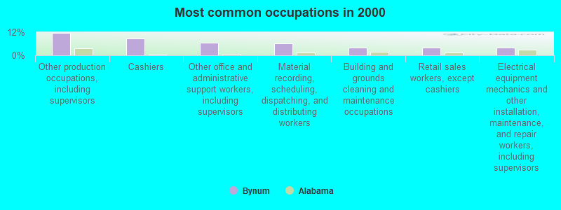
- Other production occupations, including supervisors (11.5%)
- Cashiers (8.7%)
- Other office and administrative support workers, including supervisors (6.5%)
- Material recording, scheduling, dispatching, and distributing workers (6.1%)
- Building and grounds cleaning and maintenance occupations (4.1%)
- Retail sales workers, except cashiers (4.1%)
- Electrical equipment mechanics and other installation, maintenance, and repair workers, including supervisors (4.0%)
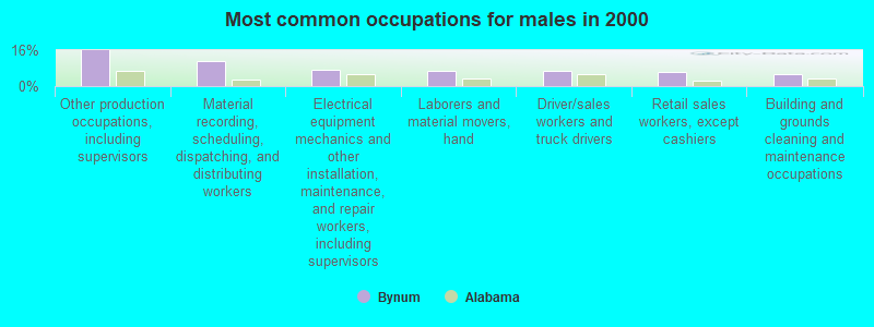
- Other production occupations, including supervisors (15.9%)
- Material recording, scheduling, dispatching, and distributing workers (11.0%)
- Electrical equipment mechanics and other installation, maintenance, and repair workers, including supervisors (7.2%)
- Laborers and material movers, hand (6.8%)
- Driver/sales workers and truck drivers (6.6%)
- Retail sales workers, except cashiers (6.2%)
- Building and grounds cleaning and maintenance occupations (5.5%)
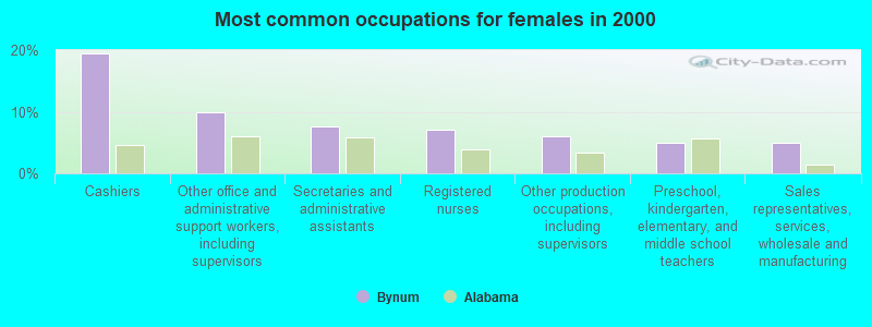
- Cashiers (19.4%)
- Other office and administrative support workers, including supervisors (10.0%)
- Secretaries and administrative assistants (7.6%)
- Registered nurses (7.1%)
- Other production occupations, including supervisors (6.0%)
- Preschool, kindergarten, elementary, and middle school teachers (5.0%)
- Sales representatives, services, wholesale and manufacturing (5.0%)
Average climate in Bynum, Alabama
Based on data reported by over 4,000 weather stations


Tornado activity:
Bynum-area historical tornado activity is slightly above Alabama state average. It is 131% greater than the overall U.S. average.
On 3/27/1994, a category F4 (max. wind speeds 207-260 mph) tornado 13.3 miles away from the Bynum place center killed 22 people and injured 150 people and caused between $5,000,000 and $50,000,000 in damages.
On 5/27/1973, a category F4 tornado 13.4 miles away from the place center killed 7 people and injured 199 people and caused between $5,000,000 and $50,000,000 in damages.
Earthquake activity:
Bynum-area historical earthquake activity is significantly above Alabama state average. It is 101% greater than the overall U.S. average.On 4/29/2003 at 08:59:39, a magnitude 4.9 (4.4 MB, 4.6 MW, 4.9 LG, Class: Light, Intensity: IV - V) earthquake occurred 64.3 miles away from Bynum center
On 1/18/1999 at 07:00:53, a magnitude 4.8 (4.8 MB, 4.0 LG, Depth: 0.6 mi) earthquake occurred 75.8 miles away from the city center
On 4/29/2003 at 08:59:39, a magnitude 4.6 (4.6 MW, Depth: 12.3 mi) earthquake occurred 64.3 miles away from Bynum center
On 10/24/1997 at 08:35:17, a magnitude 4.9 (4.8 MB, 4.2 MS, 4.9 LG, Depth: 6.2 mi) earthquake occurred 188.0 miles away from the city center
On 6/24/1975 at 11:11:36, a magnitude 4.5 (4.5 MB) earthquake occurred 108.3 miles away from Bynum center
On 8/2/1974 at 08:52:09, a magnitude 4.9 (4.3 MB, 4.9 LG) earthquake occurred 200.7 miles away from the city center
Magnitude types: regional Lg-wave magnitude (LG), body-wave magnitude (MB), surface-wave magnitude (MS), moment magnitude (MW)
Natural disasters:
The number of natural disasters in Calhoun County (17) is near the US average (15).Major Disasters (Presidential) Declared: 10
Emergencies Declared: 5
Causes of natural disasters: Storms: 10, Tornadoes: 10, Floods: 6, Hurricanes: 4, Winds: 2, Drought: 1, Snowfall: 1, Winter Storm: 1, Other: 1 (Note: some incidents may be assigned to more than one category).

Hospitals and medical centers near Bynum:
- COUNTRYSIDE HOSPICE CARE INC (Hospital, about 9 miles away; ANNISTON, AL)
- RAI-SNOW ST-OXFORD (Dialysis Facility, about 9 miles away; OXFORD, AL)
- NEW BEACON OF ANNISTON (Hospital, about 9 miles away; ANNISTON, AL)
- NORTHEAST ALABAMA REGIONAL MED CENTER Acute Care Hospitals (about 9 miles away; ANNISTON, AL)
- STRINGFELLOW MEMORIAL HOSPITAL Acute Care Hospitals (about 9 miles away; ANNISTON, AL)
- RAI EAST 11TH ST ANNISTON (Dialysis Facility, about 9 miles away; ANNISTON, AL)
- NHC HEALTHCARE, ANNISTON (Nursing Home, about 10 miles away; ANNISTON, AL)
Colleges/universities with over 2000 students nearest to Bynum:
- Jacksonville State University (about 19 miles; Jacksonville, AL; Full-time enrollment: 7,566)
- Gadsden State Community College (about 27 miles; Gadsden, AL; FT enrollment: 4,650)
- Southern Union State Community College (about 40 miles; Wadley, AL; FT enrollment: 4,120)
- Snead State Community College (about 43 miles; Boaz, AL; FT enrollment: 2,023)
- Jefferson State Community College (about 43 miles; Birmingham, AL; FT enrollment: 6,041)
- West Georgia Technical College (about 46 miles; Waco, GA; FT enrollment: 4,768)
- Samford University (about 49 miles; Birmingham, AL; FT enrollment: 3,829)
Points of interest:
Churches in Bynum include: Springhill Baptist Church (A), Bynum Methodist Church (B), Bynum Baptist Church (C), New Hope Baptist Church (D), Antioch Baptist Church (E). Display/hide their locations on the map
Cemetery: Antioch Cemetery (1). Display/hide its location on the map
| This place: | 2.5 people |
| Alabama: | 2.5 people |
| This place: | 74.5% |
| Whole state: | 70.4% |
| This place: | 3.5% |
| Whole state: | 3.4% |
Likely homosexual households (counted as self-reported same-sex unmarried-partner households)
- Lesbian couples: 0.4% of all households
- Gay men: 0.3% of all households
| This place: | 10.5% |
| Whole state: | 16.1% |
| This place: | 2.7% |
| Whole state: | 7.3% |
For population 15 years and over in Bynum:
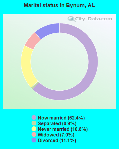
- Never married: 18.6%
- Now married: 62.4%
- Separated: 0.9%
- Widowed: 7.0%
- Divorced: 11.1%
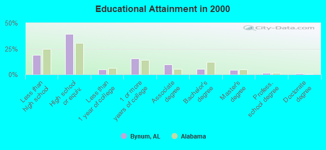
For population 25 years and over in Bynum:
- High school or higher: 81.2%
- Bachelor's degree or higher: 12.0%
- Graduate or professional degree: 6.6%
- Unemployed: 5.2%
- Mean travel time to work (commute): 24.0 minutes
| Here: | 9.8 |
| Alabama average: | 13.2 |
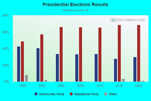

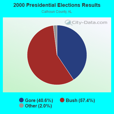
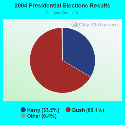

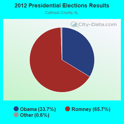
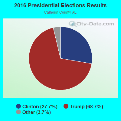
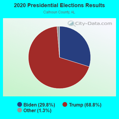
Graphs represent county-level data. Detailed 2008 Election Results
Religion statistics for Bynum, AL (based on Calhoun County data)
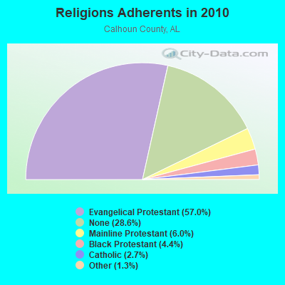
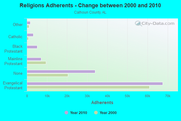
| Religion | Adherents | Congregations |
|---|---|---|
| Evangelical Protestant | 67,564 | 204 |
| Mainline Protestant | 7,066 | 42 |
| Black Protestant | 5,163 | 24 |
| Catholic | 3,192 | 4 |
| Other | 1,590 | 6 |
| Orthodox | 40 | 1 |
| None | 33,957 | - |
Food Environment Statistics:
| Calhoun County: | 2.75 / 10,000 pop. |
| Alabama: | 1.89 / 10,000 pop. |
| This county: | 0.09 / 10,000 pop. |
| Alabama: | 0.20 / 10,000 pop. |
| This county: | 0.71 / 10,000 pop. |
| State: | 0.65 / 10,000 pop. |
| Here: | 7.71 / 10,000 pop. |
| State: | 6.32 / 10,000 pop. |
| Calhoun County: | 6.73 / 10,000 pop. |
| Alabama: | 5.75 / 10,000 pop. |
| Here: | 13.5% |
| Alabama: | 11.8% |
| This county: | 33.2% |
| Alabama: | 31.7% |
| Calhoun County: | 15.1% |
| State: | 13.5% |
Strongest AM radio stations in Bynum:
- WNSI (810 AM; 50 kW; JACKSONVILLE, AL; Owner: UNITED BROADCASTING NETWORK, INC.)
- WHMA (1390 AM; 5 kW; ANNISTON, AL; Owner: CASEY NETWORK, LLC)
- WDJC (850 AM; 50 kW; BIRMINGHAM, AL; Owner: KIMTRON, INC.)
- WKNG (1060 AM; daytime; 50 kW; TALLAPOOSA, GA; Owner: WKNG, INC.)
- WJOX (690 AM; 50 kW; BIRMINGHAM, AL; Owner: CITADEL BROADCASTING COMPANY)
- WAPI (1070 AM; 50 kW; BIRMINGHAM, AL; Owner: CITADEL BROADCASTING COMPANY)
- WAAX (570 AM; 5 kW; GADSDEN, AL; Owner: CAPSTAR TX LIMITED PARTNERSHIP)
- WDNG (1450 AM; 1 kW; ANNISTON, AL; Owner: WDNG, INC.)
- WHOG (1120 AM; daytime; 0 kW; HOBSON CITY, AL; Owner: HOBSON CITY BROADCASTING CO)
- WVOK (1580 AM; 2 kW; OXFORD, AL; Owner: WOODARD B/CING. CO., INC.)
- WZZX (780 AM; daytime; 5 kW; LINEVILLE, AL; Owner: ROBERT A. PERRY)
- WGST (640 AM; 50 kW; ATLANTA, GA; Owner: CITICASTERS LICENSES, L.P.)
- WFHK (1430 AM; 5 kW; PELL CITY, AL; Owner: STOCKS BROADCASTING, INC.)
Strongest FM radio stations in Bynum:
- WVOK-FM (97.9 FM; OXFORD, AL; Owner: WOODARD BROADCASTING CO. INC.)
- WTBJ (91.3 FM; OXFORD, AL; Owner: TRINITY CHRISTIAN ACADEMY)
- W269AX (101.7 FM; ANNISTON, AL; Owner: BIBLE BROADCASTING NETWORK, INC.)
- WLJS-FM (91.9 FM; JACKSONVILLE, AL; Owner: BD. OF TRUSTEES/JACKSONVILLE STATE UNIVERSITY)
- WTDR (92.7 FM; TALLADEGA, AL; Owner: JACOBS BROADCAST GROUP, INC.)
- WSSY-FM (97.5 FM; TALLADEGA, AL; Owner: GREAT SOUTH RFDC, LLC)
- WGRW (90.7 FM; ANNISTON, AL; Owner: WORD WORKS, INC.)
- WASZ (95.5 FM; ASHLAND, AL; Owner: WILLIAMS COMMUNICATIONS, INC.)
- WRAX (107.7 FM; BIRMINGHAM, AL; Owner: CITADEL BROADCASTING COMPANY)
- WMAX-FM (105.3 FM; BOWDON, GA; Owner: CLEAR CHANNEL BROADCASTING LICENSES, INC.)
- WGMZ (93.1 FM; GLENCOE, AL; Owner: CAPSTAR TX LIMITED PARTNERSHIP)
- WRHY (105.9 FM; CENTRE, AL; Owner: WILLIAMS COMMUNICATIONS, INC.)
- WKXX (102.9 FM; ATTALLA, AL; Owner: BROADCAST MEDIA LLC)
- WQSB (105.1 FM; ALBERTVILLE, AL; Owner: SAND MOUNTAIN BROADCASTING SERVICE, INC.)
- WBPT (106.9 FM; BIRMINGHAM, AL; Owner: CXR HOLDINGS, INC.)
- WBHK (98.7 FM; WARRIOR, AL; Owner: CXR HOLDINGS, INC.)
- WZZK-FM (104.7 FM; BIRMINGHAM, AL; Owner: CXR HOLDINGS, INC.)
- WGIB (91.9 FM; BIRMINGHAM, AL; Owner: GLEN IRIS BAPTIST SCHOOL)
- WCKS (102.7 FM; FRUITHURST, AL; Owner: WCKS, INC.)
- WBHM (90.3 FM; BIRMINGHAM, AL; Owner: BD OF TRUSTEES/U OF AL AT BIRMINGHAM)
TV broadcast stations around Bynum:
- WCIQ (Channel 7; MOUNT CHEAHA, AL; Owner: ALABAMA EDUCATIONAL TELEVISION COMMISSION)
- WJXS-CA (Channel 24; JACKSONVILLE, AL; Owner: ALABAMA HERITAGE COMMUNICATIONS, L.L.C.)
- WPXH (Channel 44; GADSDEN, AL; Owner: PAXSON COMMUNICATIONS LICENSE COMPANY, LLC)
- W29AO (Channel 29; ANNISTON, AL; Owner: WBRC LICENSE, INC.)
- WTJP (Channel 60; GADSDEN, AL; Owner: TRINITY BROADCASTING NETWORK)
- WJSU-TV (Channel 40; ANNISTON, AL; Owner: TV ALABAMA, INC.)
- W63CK (Channel 63; TALLADEGA, AL; Owner: BOWLIN BROADCAST NETWORK, INC.)
Bynum fatal accident list:
- National Bridge Inventory (NBI) Statistics
- 1Number of bridges
- 3ft / 0.7mTotal length
- $196,000Total costs
- 400Total average daily traffic
- 4Total average daily truck traffic
- 700Total future (year 2040) average daily traffic
FCC Registered Antenna Towers:
5- John P Kelly, .3 Mi N Of I 20 2 Mi Sw (Lat: 33.580000 Lon: -85.994167), Type: 61.0, Overall height: 54.8 m, Registrant: Siteexcell LLC, Tunnell@siteexcell.Com, , Littl-e Rock, Phone: (501) 604-4000
- CHRISTINE A VERRE, .3 Mi N Of I 20 2 Mi Sw (Lat: 33.580000 Lon: -85.994167), Type: 61.0, Overall height: 54.8 m, Registrant: Crown Castle Pt, Inc., Monica.Gambino@crowncastle.Com, , Canon-sburg, Phone: (724) 416-2516
- CHRISTINE A VERRE, .3 Mi N Of I 20 2 Mi Sw (Lat: 33.580000 Lon: -85.994167), Type: 61.0, Overall height: 54.8 m, Registrant: Crown Castle Pt, Inc., Monica.Gambino@crowncastle.Com, , Canon-sburg, Phone: (724) 416-2516
- CHRISTINE A VERRE, .3 Mi N Of I 20 2 Mi Sw (Lat: 33.580000 Lon: -85.994167), Type: 61.0, Overall height: 54.8 m, Registrant: Crown Castle Usa Inc., Monica.Gambino@crowncastle.Com, , Canon-sburg, Phone: (724) 416-2516
- .3 Mi N Of I 20 2 Mi Sw (Lat: 33.580000 Lon: -85.994167), Type: 61.0, Overall height: 54.8 m, Registrant: Intercel Inc, West -Point, Phone: (706) 645-9925
FCC Registered Amateur Radio Licenses:
5- Call Sign: KO4RB, Previous Call Sign: KC4UEP, Grant Date: 02/04/1992, Expiration Date: 02/04/2002, Cancellation Date: 02/05/2004, Registrant: Howard L Camp, Bynum, AL 36253
- Call Sign: KG4OZI, Licensee ID: L00393818, Grant Date: 08/28/2001, Expiration Date: 08/28/2011, Cancellation Date: 08/29/2013, Certifier: Joel E Carter, Registrant: Joel E Carter, Bynum, AL 36253
- Call Sign: KJ4GII, Licensee ID: L01427319, Grant Date: 08/28/2008, Expiration Date: 08/28/2018, Cancellation Date: 08/29/2020, Certifier: Luther L Dutton, Registrant: Luther L Dutton, Bynum, AL 36253
- Call Sign: KN4WYK, Licensee ID: L02289620, Grant Date: 09/03/2019, Expiration Date: 09/03/2029, Cancellation Date: 09/24/2019, Certifier: Raymond S Lique, Registrant: Bama Hamers, Bynum, AL 36253
- Call Sign: AI4AL, Previous Call Sign: KN4WYK, Licensee ID: L02289620, Grant Date: 09/24/2019, Expiration Date: 09/24/2029, Certifier: Raymond S Lique, Registrant: Bama Hamers, Bynum, AL 36253
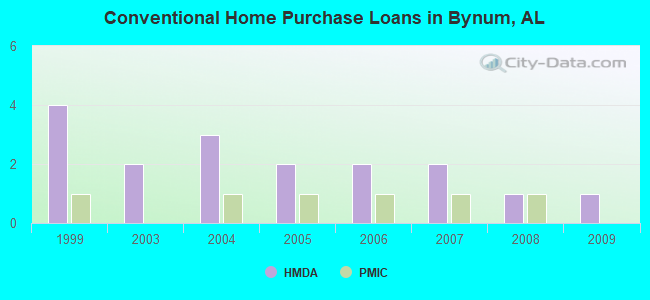
| Home Mortgage Disclosure Act Aggregated Statistics For Year 2009 (Based on 1 partial tract) | ||||||||
| A) FHA, FSA/RHS & VA Home Purchase Loans | B) Conventional Home Purchase Loans | C) Refinancings | F) Non-occupant Loans on < 5 Family Dwellings (A B C & D) | |||||
|---|---|---|---|---|---|---|---|---|
| Number | Average Value | Number | Average Value | Number | Average Value | Number | Average Value | |
| LOANS ORIGINATED | 1 | $76,200 | 1 | $33,010 | 4 | $97,955 | 1 | $35,620 |
| APPLICATIONS APPROVED, NOT ACCEPTED | 0 | $0 | 0 | $0 | 0 | $0 | 0 | $0 |
| APPLICATIONS DENIED | 0 | $0 | 0 | $0 | 2 | $96,750 | 0 | $0 |
| APPLICATIONS WITHDRAWN | 0 | $0 | 0 | $0 | 1 | $100,370 | 0 | $0 |
| FILES CLOSED FOR INCOMPLETENESS | 0 | $0 | 0 | $0 | 0 | $0 | 0 | $0 |
Detailed HMDA statistics for the following Tracts: 0015.00
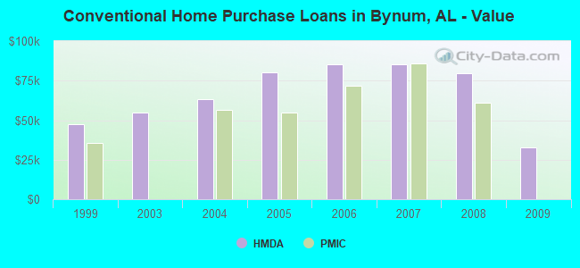
| Private Mortgage Insurance Companies Aggregated Statistics For Year 2008 (Based on 1 partial tract) | ||
| A) Conventional Home Purchase Loans | ||
|---|---|---|
| Number | Average Value | |
| LOANS ORIGINATED | 1 | $61,020 |
| APPLICATIONS APPROVED, NOT ACCEPTED | 0 | $0 |
| APPLICATIONS DENIED | 0 | $0 |
| APPLICATIONS WITHDRAWN | 0 | $0 |
| FILES CLOSED FOR INCOMPLETENESS | 0 | $0 |
Detailed PMIC statistics for the following Tracts: 0015.00
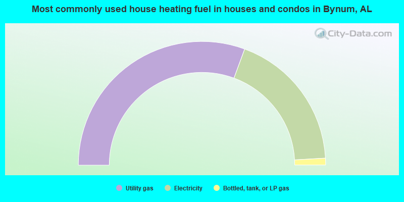
- 61.3%Utility gas
- 37.0%Electricity
- 1.8%Bottled, tank, or LP gas
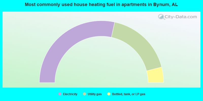
- 56.8%Electricity
- 35.1%Utility gas
- 8.1%Bottled, tank, or LP gas
Bynum compared to Alabama state average:
- Unemployed percentage below state average.
- Black race population percentage below state average.
- Hispanic race population percentage significantly below state average.
- Median age below state average.
- Foreign-born population percentage significantly below state average.
- Renting percentage significantly below state average.
- Length of stay since moving in significantly above state average.
- Number of rooms per house significantly below state average.
- House age significantly below state average.
- Percentage of population with a bachelor's degree or higher below state average.
Bynum on our top lists:
- #92 on the list of "Top 101 larger cities with the lowest real estate taxes percentage (population 50,000+)"
- #10 on the list of "Top 101 counties with the smallest number of children under 18 without health insurance coverage in 2000 (pop. 50,000+)"
- #27 on the list of "Top 101 counties with the smallest number of people without health insurance coverage in 2000 (pop. 50,000+)"
- #90 on the list of "Top 101 counties with the highest number of deaths per 1000 residents 2007-2013 (pop. 50,000+)"