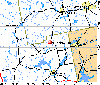
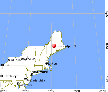
Cambridge, Maine
Submit your own pictures of this town and show them to the world
- OSM Map
- General Map
- Google Map
- MSN Map
Population change since 2000: -6.1%
 |
| Males: 229 | |
| Females: 233 |
| Median resident age: | 48.3 years |
| Maine median age: | 43.0 years |
Zip codes: 04923.
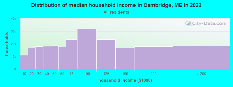
| Cambridge: | $50,609 |
| ME: | $69,543 |
Estimated per capita income in 2022: $26,521 (it was $12,624 in 2000)
Cambridge town income, earnings, and wages data
Estimated median house or condo value in 2022: $148,259 (it was $55,600 in 2000)
| Cambridge: | $148,259 |
| ME: | $290,600 |
Mean prices in 2022: all housing units: $190,782; detached houses: $204,176; townhouses or other attached units: $200,500; in 2-unit structures: $144,246; in 3-to-4-unit structures: $441,593; in 5-or-more-unit structures: $270,949; mobile homes: $101,406; occupied boats, rvs, vans, etc.: $711,279
Detailed information about poverty and poor residents in Cambridge, ME


- 44395.9%White alone
- 71.5%Two or more races
- 71.5%Hispanic
- 30.6%Asian alone
- 20.4%American Indian alone

Races in Cambridge detailed stats: ancestries, foreign born residents, place of birth
According to our research of Maine and other state lists, there was 1 registered sex offender living in Cambridge, Maine as of May 25, 2024.
The ratio of all residents to sex offenders in Cambridge is 462 to 1.
The ratio of registered sex offenders to all residents in this city is near the state average.
 Recent articles from our blog. Our writers, many of them Ph.D. graduates or candidates, create easy-to-read articles on a wide variety of topics.

 | Down East magazine (41 replies) |
| Adjusting after moving to Yarmouth from Cambridge, MA (12 replies) |
| Comparing Camden ME/ Newburyport MA (5 replies) |
| portland/portsmouth/cape cod (13 replies) |
| Home prices insane! (8 replies) |
| A possible move - 7 years in the making! (5 replies) |
Latest news from Cambridge, ME collected exclusively by city-data.com from local newspapers, TV, and radio stations
Ancestries: English (31.7%), Irish (22.0%), French (18.1%), United States (11.2%), French Canadian (7.9%), Scottish (7.5%).
Current Local Time: EST time zone
Incorporated on 02/08/1834
Elevation: 356 feet
Land area: 19.4 square miles.
Population density: 24 people per square mile (very low).
3 residents are foreign born
| This town: | 0.6% |
| Maine: | 2.9% |
| Cambridge town: | 0.9% ($481) |
| Maine: | 1.5% ($1,417) |
Nearest city with pop. 50,000+: Portland, ME  (102.9 miles , pop. 64,249).
Nearest city with pop. 200,000+: Boston, MA (204.7 miles , pop. 589,141).
Nearest city with pop. 1,000,000+: Bronx, NY (366.0 miles , pop. 1,332,650).
Nearest cities:
), ), Latitude: 45.03 N, Longitude: 69.45 W
Area code commonly used in this area: 207

Single-family new house construction building permits:
- 2022: 3 buildings, average cost: $279,200
- 2021: 1 building, cost: $259,200
- 2020: 1 building, cost: $248,200
- 2019: 4 buildings, average cost: $282,200
- 2017: 1 building, cost: $246,000
- 2016: 1 building, cost: $246,000
- 2014: 2 buildings, average cost: $211,200
- 2010: 2 buildings, average cost: $165,900
- 2009: 1 building, cost: $178,900
- 2008: 3 buildings, average cost: $182,400
- 2007: 2 buildings, average cost: $181,200
- 2006: 2 buildings, average cost: $171,000
- 2004: 5 buildings, average cost: $119,000
- 2003: 3 buildings, average cost: $40,000
- 2002: 3 buildings, average cost: $40,000
- 2001: 3 buildings, average cost: $40,000
- 2000: 3 buildings, average cost: $40,000
- 1999: 3 buildings, average cost: $40,000


| Here: | 3.1% |
| Maine: | 3.4% |


- Leather & allied products (14.0%)
- Construction (10.5%)
- Educational services (10.0%)
- Health care (8.7%)
- Textile mills & textile products (7.0%)
- Food & beverage stores (6.6%)
- Accommodation & food services (6.6%)

- Construction (17.4%)
- Leather & allied products (14.9%)
- Textile mills & textile products (9.1%)
- Agriculture, forestry, fishing & hunting (8.3%)
- Educational services (7.4%)
- Wood products (5.0%)
- Department & other general merchandise stores (4.1%)

- Health care (18.5%)
- Leather & allied products (13.0%)
- Educational services (13.0%)
- Food & beverage stores (11.1%)
- Accommodation & food services (10.2%)
- Miscellaneous manufacturing (4.6%)
- Textile mills & textile products (4.6%)

- Laborers and material movers, hand (7.9%)
- Other production occupations, including supervisors (7.0%)
- Cashiers (6.6%)
- Metal workers and plastic workers (4.8%)
- Carpenters (4.8%)
- Nursing, psychiatric, and home health aides (4.4%)
- Textile, apparel, and furnishings workers (3.9%)

- Other production occupations, including supervisors (10.7%)
- Carpenters (9.1%)
- Supervisors, construction and extraction workers (6.6%)
- Electrical equipment mechanics and other installation, maintenance, and repair workers, including supervisors (6.6%)
- Metal workers and plastic workers (6.6%)
- Laborers and material movers, hand (6.6%)
- Textile, apparel, and furnishings workers (5.8%)

- Cashiers (11.1%)
- Nursing, psychiatric, and home health aides (9.3%)
- Laborers and material movers, hand (9.3%)
- Retail sales workers, except cashiers (5.6%)
- Waiters and waitresses (4.6%)
- Secretaries and administrative assistants (4.6%)
- Other food preparation and serving workers, including supervisors (3.7%)
Average climate in Cambridge, Maine
Based on data reported by over 4,000 weather stations


Earthquake activity:
Cambridge-area historical earthquake activity is significantly above Maine state average. It is 80% smaller than the overall U.S. average.On 4/20/2002 at 10:50:47, a magnitude 5.3 (5.3 ML, Depth: 3.0 mi, Class: Moderate, Intensity: VI - VII) earthquake occurred 211.8 miles away from Cambridge center
On 4/20/2002 at 10:50:47, a magnitude 5.2 (5.2 MB, 4.2 MS, 5.2 MW, 5.0 MW) earthquake occurred 213.1 miles away from the city center
On 10/16/2012 at 23:12:25, a magnitude 4.7 (4.7 ML, Depth: 10.0 mi, Class: Light, Intensity: IV - V) earthquake occurred 115.9 miles away from the city center
On 10/7/1983 at 10:18:46, a magnitude 5.3 (5.1 MB, 5.3 LG, 5.1 ML) earthquake occurred 252.7 miles away from the city center
On 1/19/1982 at 00:14:42, a magnitude 4.7 (4.5 MB, 4.7 MD, 4.5 LG) earthquake occurred 150.3 miles away from the city center
On 2/26/1999 at 03:38:43, a magnitude 3.8 (3.8 LG, Depth: 2.0 mi, Class: Light, Intensity: II - III) earthquake occurred 38.3 miles away from Cambridge center
Magnitude types: regional Lg-wave magnitude (LG), body-wave magnitude (MB), duration magnitude (MD), local magnitude (ML), surface-wave magnitude (MS), moment magnitude (MW)
Natural disasters:
The number of natural disasters in Somerset County (24) is greater than the US average (15).Major Disasters (Presidential) Declared: 16
Emergencies Declared: 7
Causes of natural disasters: Floods: 14, Storms: 13, Snows: 7, Heavy Rains: 2, Hurricanes: 2, Blizzard: 1, Ice Storm: 1, Landslide: 1, Snowfall: 1, Wind: 1, Winter Storm: 1, Other: 1 (Note: some incidents may be assigned to more than one category).

Hospitals and medical centers near Cambridge:
- DEXTER HEALTH CARE (Nursing Home, about 8 miles away; DEXTER, ME)
- SQUARE ROAD GROUP HOME (Hospital, about 11 miles away; SAINT ALBANS, ME)
- SANFIELD REHAB AND LIVING CENTER (Nursing Home, about 11 miles away; HARTLAND, ME)
- MAYO REGIONAL HOSPITAL Critical Access Hospitals (about 15 miles away; DOVER FOXCROFT, ME)
- HIBBARD NURSING HOME (Nursing Home, about 15 miles away; DOVER FOXCROFT, ME)
Airports located in Cambridge:
- Greenfield Hill Airport (ME70) (Runways: 1)
Colleges/universities with over 2000 students nearest to Cambridge:
- Husson University (about 36 miles; Bangor, ME; Full-time enrollment: 2,421)
- University of Maine (about 39 miles; Orono, ME; FT enrollment: 8,931)
- University of Maine at Farmington (about 43 miles; Farmington, ME; FT enrollment: 2,036)
- University of Maine at Augusta (about 51 miles; Augusta, ME; FT enrollment: 3,204)
- Saint Joseph's College of Maine (about 98 miles; Standish, ME; FT enrollment: 2,010)
- University of Southern Maine (about 104 miles; Portland, ME; FT enrollment: 6,647)
- Southern Maine Community College (about 104 miles; South Portland, ME; FT enrollment: 4,666)
Points of interest:
Notable location: Cambridge Fire Department (A). Display/hide its location on the map
Cemeteries: Memorial Garden Cemetery (1), Mount Pleasant Cemetery (2). Display/hide their locations on the map
Reservoir: Cambridge Pond (A). Display/hide its location on the map
Streams, rivers, and creeks: Snow Brook (A), Jimmy Brook (B), Main Stream Sebasticook River (C), Ferguson Brook (D), Ike Brook (E), Dickey Brook (F), Page Brook (G). Display/hide their locations on the map
Drinking water stations with addresses in Cambridge and their reported violations in the past:
GLENBURN ELEM SCHOOL (Population served: 500, Groundwater):Past monitoring violations:
- 2 regular monitoring violations
| This town: | 2.4 people |
| Maine: | 2.3 people |
| This town: | 69.0% |
| Whole state: | 62.9% |
| This town: | 11.7% |
| Whole state: | 9.4% |
Likely homosexual households (counted as self-reported same-sex unmarried-partner households)
- Lesbian couples: 0.0% of all households
- Gay men: 0.5% of all households
| This town: | 13.7% |
| Whole state: | 10.9% |
| This town: | 7.6% |
| Whole state: | 4.1% |
For population 15 years and over in Cambridge:

- Never married: 19.3%
- Now married: 65.5%
- Separated: 2.1%
- Widowed: 3.0%
- Divorced: 10.1%
For population 25 years and over in Cambridge:
- High school or higher: 81.2%
- Bachelor's degree or higher: 4.9%
- Graduate or professional degree: 2.2%
- Unemployed: 6.5%
- Mean travel time to work (commute): 29.0 minutes


| Here: | 7.9 |
| Maine average: | 11.2 |

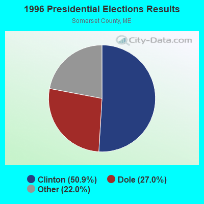
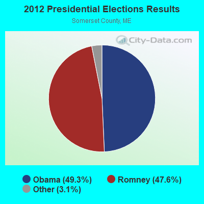
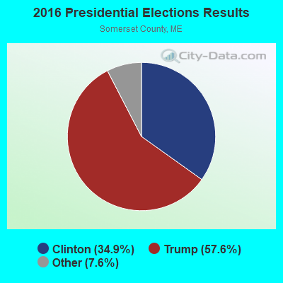
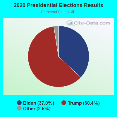
Graphs represent county-level data. Detailed 2008 Election Results
Religion statistics for Cambridge, ME (based on Somerset County data)
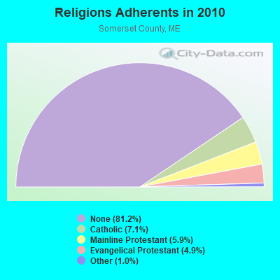
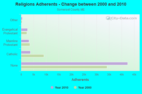
| Religion | Adherents | Congregations |
|---|---|---|
| Catholic | 3,694 | 7 |
| Mainline Protestant | 3,094 | 28 |
| Evangelical Protestant | 2,552 | 32 |
| Other | 501 | 3 |
| None | 42,387 | - |
Food Environment Statistics:
| This county: | 2.52 / 10,000 pop. |
| State: | 2.80 / 10,000 pop. |
| Somerset County: | 0.19 / 10,000 pop. |
| Maine: | 0.14 / 10,000 pop. |
| This county: | 2.71 / 10,000 pop. |
| State: | 2.20 / 10,000 pop. |
| Somerset County: | 9.31 / 10,000 pop. |
| Maine: | 5.75 / 10,000 pop. |
| Here: | 8.14 / 10,000 pop. |
| Maine: | 11.02 / 10,000 pop. |
| This county: | 10.2% |
| Maine: | 8.2% |
| Here: | 31.7% |
| Maine: | 25.0% |
Strongest AM radio stations in Cambridge:
- WSKW (1160 AM; 10 kW; SKOWHEGAN, ME; Owner: MOUNTAIN WIRELESS, INCORPORATED)
- WZON (620 AM; 5 kW; BANGOR, ME; Owner: THE ZONE CORPORATION)
- WABI (910 AM; 5 kW; BANGOR, ME; Owner: CLEAR CHANNEL BROADCASTING LICENSES, INC.)
- WTME (780 AM; 10 kW; RUMFORD, ME; Owner: MOUNTAIN VALLEY BROADCASTING, INC.)
- WRKO (680 AM; 50 kW; BOSTON, MA; Owner: ENTERCOM BOSTON LICENSE, LLC)
- WEEI (850 AM; 50 kW; BOSTON, MA; Owner: ENTERCOM BOSTON LICENSE, LLC)
- WFAU (1280 AM; 5 kW; GARDINER, ME; Owner: CAPSTAR TX LIMITED PARTNERSHIP)
- WCHP (760 AM; 35 kW; CHAMPLAIN, NY; Owner: CHAMPLAIN RADIO, INC.)
- WBZ (1030 AM; 50 kW; BOSTON, MA; Owner: INFINITY BROADCASTING OPERATIONS, INC.)
- WCRN (830 AM; 50 kW; WORCESTER, MA; Owner: CARTER BROADCASTING CORPORATION)
- WNNZ (640 AM; 50 kW; WESTFIELD, MA; Owner: CLEAR CHANNEL BROADCASTING LICENSES, INC.)
- WDEA (1370 AM; 5 kW; ELLSWORTH, ME; Owner: CUMULUS LICENSING CORP.)
- WMTW (870 AM; 10 kW; GORHAM, ME; Owner: RADIO PARTNERS OF MAINE, L.P.)
Strongest FM radio stations in Cambridge:
- WGUY (102.1 FM; DEXTER, ME; Owner: CONCORD MEDIA GROUP, INC.)
- WQCB (106.5 FM; BREWER, ME; Owner: CUMULUS LICENSING CORP.)
- WTOS-FM (105.1 FM; SKOWHEGAN, ME; Owner: CAPSTAR TX LIMITED PARTNERSHIP)
- WWBX (97.1 FM; BANGOR, ME; Owner: CLEAR CHANNEL BROADCASTING LICENSES, INC.)
- WJCX (99.5 FM; PITTSFIELD, ME; Owner: CSN INTERNATIONAL)
- WVOM (103.9 FM; HOWLAND, ME; Owner: CLEAR CHANNEL BROADCASTING LICENSES, INC.)
- WHQO (107.9 FM; SKOWHEGAN, ME; Owner: MOUNTAIN WIRELESS, INC.)
- WDME-FM (103.1 FM; DOVER-FOXCROFT, ME; Owner: THE ZONE CORPORATION)
- WHCF (88.5 FM; BANGOR, ME; Owner: BANGOR BAPTIST CHURCH)
- WBFB (104.7 FM; BELFAST, ME; Owner: CLEAR CHANNEL BROADCASTING LICENSES, INC.)
- WCTB (93.5 FM; FAIRFIELD, ME; Owner: MOUNTAIN WIRELESS, INC.)
- WKIT-FM (100.3 FM; BREWER, ME; Owner: THE ZONE CORPORATION)
TV broadcast stations around Cambridge:
- WABI-TV (Channel 5; BANGOR, ME; Owner: COMMUNITY BROADCASTING SERVICE)
Cambridge fatal accident list:
Oct 7, 2001 02:45 PM, Chandler Hill Road, Vehicles: 2, Persons: 3, Fatalities: 1
Jul 5, 1999 00:30 AM, Dexter Cambridge Rd, Vehicles: 1, Persons: 2, Fatalities: 1
- National Bridge Inventory (NBI) Statistics
- 4Number of bridges
- 16ft / 4.7mTotal length
- 2,115Total average daily traffic
- 104Total average daily truck traffic
- 3,266Total future (year 2036) average daily traffic
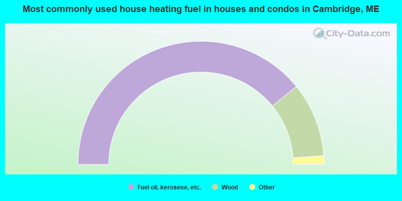
- 78.3%Fuel oil, kerosene, etc.
- 19.6%Wood
- 1.1%Electricity
- 1.1%Coal or coke
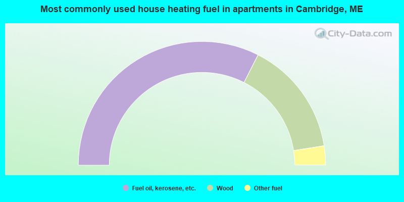
- 65.0%Fuel oil, kerosene, etc.
- 30.0%Wood
- 5.0%Other fuel
Cambridge compared to Maine state average:
- Median house value below state average.
- Unemployed percentage below state average.
- Black race population percentage significantly below state average.
- Median age above state average.
- Foreign-born population percentage significantly below state average.
- Renting percentage significantly below state average.
- Length of stay since moving in significantly above state average.
- Number of rooms per house significantly below state average.
- House age significantly below state average.
- Percentage of population with a bachelor's degree or higher significantly below state average.