Camdenton, Missouri
Submit your own pictures of this city and show them to the world
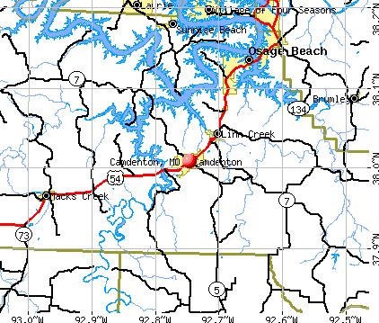
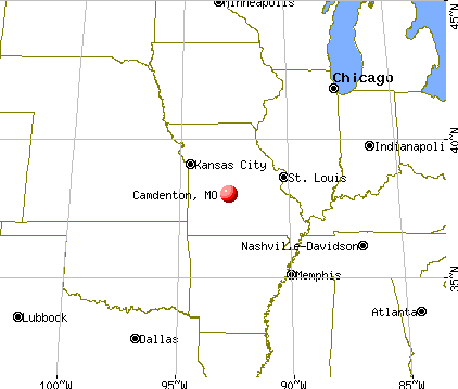
- OSM Map
- General Map
- Google Map
- MSN Map
Population change since 2000: +45.6%
| Males: 1,995 | |
| Females: 2,051 |
| Median resident age: | 33.1 years |
| Missouri median age: | 39.1 years |
| Camdenton: | $45,062 |
| MO: | $64,811 |
Estimated per capita income in 2022: $24,111 (it was $14,040 in 2000)
Camdenton city income, earnings, and wages data
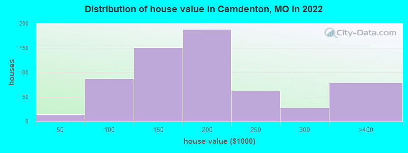
Estimated median house or condo value in 2022: $173,055 (it was $69,000 in 2000)
| Camdenton: | $173,055 |
| MO: | $221,200 |
Mean prices in 2022: all housing units: $337,184; detached houses: $368,185; townhouses or other attached units: $330,912; in 2-unit structures: $275,336; in 3-to-4-unit structures: $196,339; in 5-or-more-unit structures: $278,052; mobile homes: $97,969; occupied boats, rvs, vans, etc.: $72,242
Median gross rent in 2022: $769.
(24.7% for White Non-Hispanic residents, 2.8% for Black residents, 58.6% for Hispanic or Latino residents, 100.0% for American Indian residents, 33.9% for two or more races residents)
Detailed information about poverty and poor residents in Camdenton, MO


Compare current foreclosures near Camdenton, MO:
| Photo | Address | Area | Beds / Baths | Price | Details |
|---|---|---|---|---|---|

|
#1
Old Fifty Four Rd # 54
Camdenton, MO 65020
|
- sq. feet
|
1 baths 2 beds |
$19,900
|
show details |

|
#2
Enid Ln
Camdenton, MO 65020
|
- sq. feet
|
- baths - beds |
show details | |

|
#3
Wading Bird Rd
Camdenton, MO 65020
|
- sq. feet
|
- baths - beds |
show details | |

|
#4
Tonka Spring Rd
Camdenton, MO 65020
|
- sq. feet
|
- baths - beds |
show details | |

|
#5
Bent Tree Ln
Camdenton, MO 65020
|
- sq. feet
|
- baths - beds |
show details | |

|
#6
Camden Manor Dr # 10
Camdenton, MO 65020
|
- sq. feet
|
- baths - beds |
show details | |

|
#7
Gray Fox Run # 1
Camdenton, MO 65020
|
- sq. feet
|
- baths - beds |
show details | |

|
#8
Country Club Shores Rd
Camdenton, MO 65020
|
- sq. feet
|
- baths - beds |
show details | |

|
#9
Weiskopf Way
Camdenton, MO 65020
|
- sq. feet
|
- baths - beds |
show details | |

|
#10
Curvy Rd
Camdenton, MO 65020
|
- sq. feet
|
- baths - beds |
show details |
| Photo | Address | Area | Beds / Baths | Price | Details |
|---|---|---|---|---|---|

|
#11
N High St
Camdenton, MO 65020
|
- sq. feet
|
- baths - beds |
show details | |

|
#12
Briarcliff Rd
Camdenton, MO 65020
|
- sq. feet
|
- baths - beds |
show details | |

|
#13
Snapdragon Dr
Camdenton, MO 65020
|
- sq. feet
|
- baths - beds |
show details | |

|
#14
Elm Tree Ln
Camdenton, MO 65020
|
- sq. feet
|
- baths - beds |
show details | |

|
#15
Water Tower Rd
Camdenton, MO 65020
|
- sq. feet
|
- baths - beds |
show details | |

|
#16
Spencer Creek Rd
Camdenton, MO 65020
|
- sq. feet
|
- baths - beds |
show details | |

|
#17
Primrose Ln
Camdenton, MO 65020
|
- sq. feet
|
- baths - beds |
show details | |

|
#18
Osborn Dr
Lebanon, MO 65536
|
2,283 sq. feet
|
1 baths - beds |
show details | |

|
#19
Bittersweet Rd # 1102
Lake Ozark, MO 65049
|
- sq. feet
|
3 baths 4 beds |
show details | |

|
#20
Overlook Rd
Lake Ozark, MO 65049
|
1,458 sq. feet
|
- baths 3 beds |
show details |
| Photo | Address | Area | Beds / Baths | Price | Details |
|---|---|---|---|---|---|

|
#21
Cherokee Rd # 2a
Lake Ozark, MO 65049
|
- sq. feet
|
- baths - beds |
show details | |

|
#22
Pawnee Dr
Lebanon, MO 65536
|
- sq. feet
|
- baths - beds |
show details | |

|
#23
Oak View Rd
Osage Beach, MO 65065
|
- sq. feet
|
- baths - beds |
show details | |

|
#24
Wood River Rd # B
Lake Ozark, MO 65049
|
- sq. feet
|
- baths - beds |
show details | |

|
#25
Highway C
Brumley, MO 65017
|
- sq. feet
|
- baths - beds |
show details | |

|
#26
Wilmore Cir, C O Albert Pelate
Lake Ozark, MO 65049
|
- sq. feet
|
- baths - beds |
show details | |

|
#27
Ballenger Dr # 2b
Lake Ozark, MO 65049
|
- sq. feet
|
- baths - beds |
show details | |

|
#28
Highway C
Brumley, MO 65017
|
- sq. feet
|
- baths - beds |
show details | |

|
#29
Skywater Rd
Gravois Mills, MO 65037
|
- sq. feet
|
- baths - beds |
show details | |

|
#30
Village Marina Rd
Eldon, MO 65026
|
- sq. feet
|
- baths - beds |
show details |
| Photo | Address | Area | Beds / Baths | Price | Details |
|---|---|---|---|---|---|

|
#31
Village Marina Rd
Eldon, MO 65026
|
- sq. feet
|
- baths - beds |
show details | |

|
#32
Mace Rd
Osage Beach, MO 65065
|
- sq. feet
|
- baths - beds |
show details | |

|
#33
Mace Rd Apt 4
Osage Beach, MO 65065
|
- sq. feet
|
- baths - beds |
show details | |

|
#34
Jefferies Cir
Montreal, MO 65591
|
- sq. feet
|
- baths - beds |
show details | |

|
#35
Sweetwater Dr
Lake Ozark, MO 65049
|
- sq. feet
|
- baths - beds |
show details | |

|
#36
Riley Rd
Montreal, MO 65591
|
- sq. feet
|
- baths - beds |
show details | |

|
#37
Matson Ln
Linn Creek, MO 65052
|
- sq. feet
|
- baths - beds |
show details | |

|
#38
State Road Y
Linn Creek, MO 65052
|
- sq. feet
|
- baths - beds |
show details | |

|
#39
Black Bear Dr
Linn Creek, MO 65052
|
- sq. feet
|
- baths - beds |
show details | |

|
#40
Osage Beach Pkwy Ste A
Osage Beach, MO 65065
|
- sq. feet
|
- baths - beds |
show details |
| Photo | Address | Area | Beds / Baths | Price | Details |
|---|---|---|---|---|---|

|
#41
Mailhack Rd
Macks Creek, MO 65786
|
- sq. feet
|
- baths - beds |
show details | |

|
#42
Doc Ridgeway Rd
Roach, MO 65787
|
- sq. feet
|
- baths - beds |
show details | |

|
#43
A O Kae Ln
Montreal, MO 65591
|
- sq. feet
|
- baths - beds |
show details | |

|
#44
Highway C
Ulman, MO 65083
|
- sq. feet
|
- baths - beds |
show details | |

|
#45
Rock Ridge Ln # A
Osage Beach, MO 65065
|
- sq. feet
|
- baths - beds |
show details | |

|
#46
3 Seasons Rd
Osage Beach, MO 65065
|
- sq. feet
|
- baths - beds |
show details | |

|
#47
Baydy Peak Rd
Osage Beach, MO 65065
|
- sq. feet
|
- baths - beds |
show details | |

|
#48
Baydy Peak Rd
Osage Beach, MO 65065
|
- sq. feet
|
- baths - beds |
show details | |

|
#49
Fall St Unit A
Osage Beach, MO 65065
|
- sq. feet
|
- baths - beds |
show details | |

|
Check over 1 million property listings on Foreclosure.com!
|
browse all offers | |||


- 3,55789.1%White alone
- 2406.0%Hispanic
- 761.9%Black alone
- 461.2%Two or more races
- 250.6%American Indian alone
- 170.4%Asian alone

Races in Camdenton detailed stats: ancestries, foreign born residents, place of birth
According to our research of Missouri and other state lists, there were 49 registered sex offenders living in Camdenton, Missouri as of May 22, 2024.
The ratio of all residents to sex offenders in Camdenton is 79 to 1.
Type |
2009 |
2010 |
2011 |
2012 |
2013 |
2014 |
2015 |
2016 |
2017 |
2018 |
2019 |
2020 |
2021 |
2022 |
|---|---|---|---|---|---|---|---|---|---|---|---|---|---|---|
| Murders (per 100,000) | 0 (0.0) | 0 (0.0) | 0 (0.0) | 0 (0.0) | 0 (0.0) | 1 (26.1) | 0 (0.0) | 0 (0.0) | 0 (0.0) | 0 (0.0) | 0 (0.0) | 0 (0.0) | 0 (0.0) | 0 (0.0) |
| Rapes (per 100,000) | 0 (0.0) | 0 (0.0) | 2 (53.6) | 1 (27.0) | 2 (52.5) | 0 (0.0) | 2 (51.7) | 0 (0.0) | 5 (125.6) | 5 (121.8) | 0 (0.0) | 6 (143.2) | 4 (95.6) | 4 (98.2) |
| Robberies (per 100,000) | 1 (28.0) | 0 (0.0) | 0 (0.0) | 0 (0.0) | 0 (0.0) | 0 (0.0) | 0 (0.0) | 1 (25.6) | 0 (0.0) | 0 (0.0) | 2 (48.3) | 1 (23.9) | 0 (0.0) | 0 (0.0) |
| Assaults (per 100,000) | 5 (140.1) | 19 (511.0) | 24 (643.1) | 21 (567.9) | 13 (341.2) | 18 (470.3) | 21 (542.8) | 12 (307.1) | 10 (251.3) | 5 (121.8) | 16 (386.7) | 12 (286.3) | 9 (215.0) | 16 (392.7) |
| Burglaries (per 100,000) | 15 (420.3) | 22 (591.7) | 15 (401.9) | 29 (784.2) | 17 (446.2) | 16 (418.1) | 20 (516.9) | 15 (383.9) | 21 (527.6) | 18 (438.4) | 46 (1,112) | 25 (596.5) | 15 (358.3) | 22 (540.0) |
| Thefts (per 100,000) | 114 (3,194) | 130 (3,497) | 152 (4,073) | 233 (6,301) | 218 (5,722) | 139 (3,632) | 117 (3,024) | 169 (4,326) | 173 (4,347) | 169 (4,116) | 152 (3,673) | 102 (2,434) | 97 (2,317) | 139 (3,412) |
| Auto thefts (per 100,000) | 3 (84.1) | 1 (26.9) | 2 (53.6) | 7 (189.3) | 8 (210.0) | 5 (130.7) | 10 (258.5) | 9 (230.4) | 10 (251.3) | 12 (292.3) | 5 (120.8) | 15 (357.9) | 9 (215.0) | 7 (171.8) |
| Arson (per 100,000) | 0 (0.0) | 0 (0.0) | 0 (0.0) | 0 (0.0) | 0 (0.0) | 2 (52.3) | 0 (0.0) | 0 (0.0) | 0 (0.0) | 1 (24.4) | 0 (0.0) | 2 (47.7) | 0 (0.0) | 0 (0.0) |
| City-Data.com crime index | 200.3 | 285.6 | 366.8 | 457.3 | 387.1 | 331.3 | 327.7 | 287.4 | 381.7 | 340.5 | 326.2 | 346.7 | 254.4 | 345.1 |
The City-Data.com crime index weighs serious crimes and violent crimes more heavily. Higher means more crime, U.S. average is 246.1. It adjusts for the number of visitors and daily workers commuting into cities.

Crime rate in Camdenton detailed stats: murders, rapes, robberies, assaults, burglaries, thefts, arson
Full-time law enforcement employees in 2021, including police officers: 17 (15 officers - 14 male; 1 female).
| Officers per 1,000 residents here: | 3.58 |
| Missouri average: | 2.54 |
 Recent articles from our blog. Our writers, many of them Ph.D. graduates or candidates, create easy-to-read articles on a wide variety of topics.


Latest news from Camdenton, MO collected exclusively by city-data.com from local newspapers, TV, and radio stations
Ancestries: American (39.6%), German (13.6%), English (6.6%), Irish (3.8%), Italian (1.7%), Syrian (1.4%).
Current Local Time: CST time zone
Incorporated in 1931
Elevation: 1043 feet
Land area: 3.49 square miles.
Population density: 1,158 people per square mile (low).
143 residents are foreign born (2.8% Europe, 0.9% Latin America).
| This city: | 3.6% |
| Missouri: | 4.2% |
Median real estate property taxes paid for housing units with mortgages in 2022: $1,019 (0.5%)
Median real estate property taxes paid for housing units with no mortgage in 2022: $760 (0.5%)
Nearest city with pop. 50,000+: Springfield, MO  (63.6 miles , pop. 151,580).
Nearest city with pop. 200,000+: Kansas City, MO (122.6 miles , pop. 441,545).
Nearest city with pop. 1,000,000+: Chicago, IL (377.3 miles , pop. 2,896,016).
Nearest cities:
), Latitude: 38.01 N, Longitude: 92.75 W
Daytime population change due to commuting: +2,477 (+62.0%)
Workers who live and work in this city: 807 (43.7%)
Area code: 573

Camdenton, Missouri accommodation & food services, waste management - Economy and Business Data
Single-family new house construction building permits:
- 2022: 9 buildings, average cost: $227,900
- 2021: 9 buildings, average cost: $161,200
- 2020: 4 buildings, average cost: $131,500
- 2019: 7 buildings, average cost: $108,600
- 2018: 5 buildings, average cost: $138,900
- 2017: 5 buildings, average cost: $103,200
- 2016: 16 buildings, average cost: $165,600
- 2015: 11 buildings, average cost: $92,800
- 2014: 14 buildings, average cost: $91,000
- 2013: 16 buildings, average cost: $91,300
- 2012: 6 buildings, average cost: $60,000
- 2011: 5 buildings, average cost: $57,000
- 2010: 19 buildings, average cost: $83,100
- 2009: 16 buildings, average cost: $107,700
- 2008: 25 buildings, average cost: $82,800
- 2007: 37 buildings, average cost: $93,200
- 2006: 40 buildings, average cost: $90,200
- 2005: 31 buildings, average cost: $82,100
- 2004: 20 buildings, average cost: $76,200
- 2003: 20 buildings, average cost: $75,200
- 2002: 20 buildings, average cost: $70,500
- 2001: 3 buildings, average cost: $87,000
- 2000: 3 buildings, average cost: $56,700
- 1999: 10 buildings, average cost: $46,100
- 1998: 6 buildings, average cost: $65,000
- 1997: 8 buildings, average cost: $63,300


| Here: | 4.2% |
| Missouri: | 2.8% |


Population change in the 1990s: +175 (+6.7%).

- Accommodation & food services (13.1%)
- Health care (9.3%)
- Construction (7.9%)
- Public administration (7.1%)
- Educational services (7.0%)
- Food & beverage stores (4.4%)
- Social assistance (4.1%)

- Construction (16.1%)
- Accommodation & food services (14.1%)
- Public administration (7.5%)
- Transportation equipment (6.0%)
- Food & beverage stores (4.2%)
- Health care (4.0%)
- Machinery (3.3%)

- Health care (13.9%)
- Accommodation & food services (12.2%)
- Educational services (10.3%)
- Public administration (6.8%)
- Social assistance (6.4%)
- Food & beverage stores (4.7%)
- Department & other general merchandise stores (3.8%)

- Retail sales workers, except cashiers (4.3%)
- Other sales and related occupations, including supervisors (4.1%)
- Building and grounds cleaning and maintenance occupations (3.7%)
- Other office and administrative support workers, including supervisors (3.5%)
- Secretaries and administrative assistants (3.4%)
- Cooks and food preparation workers (3.4%)
- Other management occupations, except farmers and farm managers (3.1%)

- Other food preparation and serving workers, including supervisors (6.1%)
- Building and grounds cleaning and maintenance occupations (6.0%)
- Vehicle and mobile equipment mechanics, installers, and repairers (5.5%)
- Electrical equipment mechanics and other installation, maintenance, and repair workers, including supervisors (5.3%)
- Other sales and related occupations, including supervisors (5.1%)
- Carpenters (4.3%)
- Sales representatives, services, wholesale and manufacturing (4.3%)

- Secretaries and administrative assistants (6.4%)
- Retail sales workers, except cashiers (6.2%)
- Other office and administrative support workers, including supervisors (5.8%)
- Child care workers (5.4%)
- Cooks and food preparation workers (5.0%)
- Cashiers (5.0%)
- Waiters and waitresses (4.8%)
Average climate in Camdenton, Missouri
Based on data reported by over 4,000 weather stations


|
|


Tornado activity:
Camdenton-area historical tornado activity is slightly below Missouri state average. It is 22% greater than the overall U.S. average.
On 5/4/2003, a category F3 (max. wind speeds 158-206 mph) tornado 8.8 miles away from the Camdenton city center killed 4 people and injured 27 people and caused $5 million in damages.
On 5/4/2003, a category F3 tornado 19.3 miles away from the city center killed 5 people and injured 47 people and caused $52 million in damages.
Earthquake activity:
Camdenton-area historical earthquake activity is significantly above Missouri state average. It is 478% greater than the overall U.S. average.On 9/3/2016 at 12:02:44, a magnitude 5.8 (5.8 MW, Depth: 3.5 mi, Class: Moderate, Intensity: VI - VII) earthquake occurred 255.1 miles away from the city center
On 11/6/2011 at 03:53:10, a magnitude 5.7 (5.7 MW, Depth: 3.2 mi) earthquake occurred 280.9 miles away from the city center
On 9/26/1990 at 13:18:51, a magnitude 5.0 (4.7 MB, 4.8 LG, 5.0 LG, Depth: 7.7 mi) earthquake occurred 185.4 miles away from Camdenton center
On 4/18/2008 at 09:36:59, a magnitude 5.4 (5.1 MB, 4.8 MS, 5.4 MW, 5.2 MW) earthquake occurred 265.8 miles away from the city center
On 5/4/1991 at 01:18:54, a magnitude 5.0 (4.4 MB, 4.6 LG, 5.0 LG, Depth: 3.1 mi) earthquake occurred 189.4 miles away from the city center
On 3/25/1976 at 00:41:20, a magnitude 5.0 (4.9 MB, 5.0 LG) earthquake occurred 211.8 miles away from the city center
Magnitude types: regional Lg-wave magnitude (LG), body-wave magnitude (MB), surface-wave magnitude (MS), moment magnitude (MW)
Natural disasters:
The number of natural disasters in Camden County (24) is greater than the US average (15).Major Disasters (Presidential) Declared: 14
Emergencies Declared: 6
Causes of natural disasters: Floods: 13, Storms: 12, Tornadoes: 10, Winter Storms: 7, Winds: 5, Drought: 1, Fire: 1, Heavy Rain: 1, Hurricane: 1, Snowstorm: 1, Other: 1 (Note: some incidents may be assigned to more than one category).

Hospitals and medical centers in Camdenton:
- CAMDENTON WINDSOR ESTATES (2042 HIGHWAY 5 NORTH)
- WINDSOR ESTATES NURSING HOME (NORTH 5 HIGHWAY P O BOX 812)
Other hospitals and medical centers near Camdenton:
- OZARK REHABILITATION AND HEALTH CARE CENTER (Nursing Home, about 9 miles away; OSAGE BEACH, MO)
- OSAGE BEACH REHABILITATION AND HEALTH CARE CENTER (Nursing Home, about 11 miles away; OSAGE BEACH, MO)
- LAKESIDE MEADOWS-A STONEBRIDGE COMMUNITY (Nursing Home, about 14 miles away; OSAGE BEACH, MO)
- LAURIE CARE CENTER (Nursing Home, about 15 miles away; LAURIE, MO)
Airports located in Camdenton:
- Camdenton Memorial-Lake Regional Airport (OZS) (Runways: 1, Itinerant Ops: 5,500, Local Ops: 3,500, Military Ops: 100)
- Mistwood Airport (24MO) (Runways: 1)
College/University in Camdenton:
Colleges/universities with over 2000 students nearest to Camdenton:
- Southwest Baptist University (about 46 miles; Bolivar, MO; Full-time enrollment: 2,783)
- Lincoln University (about 50 miles; Jefferson City, MO; FT enrollment: 2,348)
- Missouri University of Science and Technology (about 54 miles; Rolla, MO; FT enrollment: 6,486)
- State Fair Community College (about 56 miles; Sedalia, MO; FT enrollment: 3,581)
- Evangel University (about 62 miles; Springfield, MO; FT enrollment: 2,036)
- Drury University (about 63 miles; Springfield, MO; FT enrollment: 3,902)
- Ozarks Technical Community College (about 63 miles; Springfield, MO; FT enrollment: 10,356)
Public high schools in Camdenton:
- CAMDENTON HIGH (Students: 1,423, Location: 1409 TOWNSHIP ROAD, Grades: 9-12)
- JUVENILE JUSTICE CTR. (Students: 2, Location: HWY 54, Grades: 5-12)
- LAKE CAREER TECHNICAL CTR. (Location: TOWNSHIP ROAD, Grades: 9-12)
Private high school in Camdenton:
Public elementary/middle schools in Camdenton:
- DOGWOOD ELEM. (Students: 910, Location: 172 DARE BLVD, Grades: PK-2)
- OAK RIDGE INTERMEDIATE (Students: 826, Location: TOWNSHIP ROAD, Grades: 5-6)
- CAMDENTON MIDDLE (Students: 671, Location: 88 LAKER LANE, Grades: 7-8)
- HAWTHORN ELEM. (Location: 172 DARE BLVD, Grades: 3-4)
Points of interest:
Notable locations in Camdenton: Rodeo Arena (A), Camdenton Fire Department (B), Mid - County Fire Protection District Station 1 Headquarters (C). Display/hide their locations on the map
Cemetery: Dale Blair Memorial Cemetery (1). Display/hide its location on the map
Tourist attractions: Lake of the Ozarks State Park - Visitors Center (Caverns; Highway A), Orion Science Center (Cultural Attractions- Events- & Facilities; Highway 5), Big Shot Amusement Park (Amusement & Theme Parks; Highway 54 & Y), Camdenton Area Chamber of Commerce (Po Box 1375).
Hotels: Flame Resort (State Road Ee), Camdenton Inn (131 East Highway 54), Five-81 Motel & Mobil Home Park (5649 North State Highway 5), A & J Motel (401 West Highway 54), El Kay Lake View Motel & Resort (Highway 5 North), Lan-O-Lak Motel (131 East Highway 54).
Drinking water stations with addresses in Camdenton and their reported violations in the past:
CAMDENTON (Population served: 3,718, Groundwater):Past monitoring violations:CAMDEN CO PWSD 2 (Population served: 1,400, Groundwater):
- One minor monitoring violation
Past health violations:CAMDEN CO PWSD 3 (Population served: 850, Groundwater):
- MCL, Monthly (TCR) - In NOV-2010, Contaminant: Coliform. Follow-up actions: St Public Notif requested (NOV-30-2010), St Violation/Reminder Notice (NOV-30-2010), St Public Notif received (DEC-27-2010), St Compliance achieved (AUG-12-2011)
Past monitoring violations:CIMARRON BAY SUBDIVISION (Address: 840 THUNDER MOUNTAIN RD , Population served: 160, Groundwater):
- Initial Tap Sampling for Pb and Cu - In JUL-01-2010, Contaminant: Lead and Copper Rule. Follow-up actions: St Public Notif requested (OCT-14-2010), St Violation/Reminder Notice (OCT-14-2010), St Public Notif received (AUG-30-2011), St Compliance achieved (OCT-07-2011)
Past monitoring violations:LAKE VALLEY CONDOMINIUM (Population served: 150, Groundwater):
- Initial Tap Sampling for Pb and Cu - In JUL-01-2002, Contaminant: Lead and Copper Rule. Follow-up actions: St BCA signed (JAN-30-2002), St Civil Case referred to AG (JUN-27-2005), St Compliance achieved (AUG-20-2007), St BCA signed (JAN-29-2008), St Compliance achieved (FEB-27-2009)
- Initial Tap Sampling for Pb and Cu - In JAN-11-2000, Contaminant: Lead and Copper Rule. Follow-up actions: St Compliance achieved (OCT-26-2001), St BCA signed (JAN-30-2002), St Formal NOV issued (JUL-19-2004), St Civil Case referred to AG (JUN-27-2005), St Compliance achieved (AUG-20-2007), St BCA signed (JAN-29-2008), St Compliance achieved (FEB-27-2009)
Past monitoring violations:LARRYS ON THE LAKE (Population served: 100, Groundwater):
- 3 minor monitoring violations
Past health violations:MARINERS PIER 31 YACHT CLUB (Population served: 100, Groundwater):Past monitoring violations:
- MCL, Monthly (TCR) - In DEC-2011, Contaminant: Coliform. Follow-up actions: St Public Notif received (JAN-03-2012), St Public Notif requested (JAN-10-2012), St Violation/Reminder Notice (JAN-10-2012), St Compliance achieved (JAN-22-2014)
- One routine major monitoring violation
- One regular monitoring violation
Past health violations:NORTH SHORE CONDOMINIUMS (Address: 515 OLD HWY 5 SOUTH , Population served: 100, Groundwater):Past monitoring violations:
- MCL, Monthly (TCR) - In AUG-2013, Contaminant: Coliform. Follow-up actions: St Civil Case referred to AG (OCT-06-2009), St Public Notif requested (AUG-12-2013), St Formal NOV issued (AUG-12-2013), St Violation/Reminder Notice (AUG-26-2013), St Compliance achieved (APR-04-2014)
- MCL, Monthly (TCR) - In SEP-2012, Contaminant: Coliform. Follow-up actions: St Civil Case referred to AG (OCT-06-2009), St Formal NOV issued (OCT-03-2012), St Public Notif requested (OCT-03-2012), St Public Notif received (JAN-18-2013), St Violation/Reminder Notice (AUG-26-2013), St Compliance achieved (APR-04-2014)
- MCL, Monthly (TCR) - In SEP-2010, Contaminant: Coliform. Follow-up actions: St Civil Case referred to AG (OCT-06-2009), St Public Notif requested (OCT-13-2010), St Violation/Reminder Notice (OCT-13-2010), St Public Notif issued (NOV-30-2010), St Compliance achieved (APR-04-2014)
- MCL, Monthly (TCR) - In SEP-2009, Contaminant: Coliform. Follow-up actions: St Public Notif requested (OCT-01-2009), St Violation/Reminder Notice (OCT-01-2009), St Civil Case referred to AG (OCT-06-2009), St Public Notif issued (2 times from SEP-23-2010 to NOV-30-2010), St Compliance achieved (APR-04-2014)
- MCL, Monthly (TCR) - In MAY-2009, Contaminant: Coliform. Follow-up actions: St Violation/Reminder Notice (JUN-04-2009), St Public Notif requested (JUN-04-2009), St Public Notif received (JUL-14-2009), St Civil Case referred to AG (OCT-06-2009), St Public Notif issued (2 times from SEP-23-2010 to NOV-30-2010), St Compliance achieved (APR-04-2014)
- Monitoring, Source Water (GWR) - In JUL-01-2013, Contaminant: E. COLI. Follow-up actions: St Public Notif requested (JUL-19-2013), St Violation/Reminder Notice (2 times from JUL-19-2013 to AUG-26-2013), St Public Notif received (MAR-24-2014)
- Monitoring, Repeat Major (TCR) - In JUN-2013, Contaminant: Coliform (TCR). Follow-up actions: St Civil Case referred to AG (OCT-06-2009), St Public Notif requested (JUL-19-2013), St Violation/Reminder Notice (2 times from JUL-19-2013 to AUG-26-2013), St Compliance achieved (APR-04-2014)
- Monitoring, Source Water (GWR) - In OCT-01-2012, Contaminant: E. COLI. Follow-up actions: St Public Notif requested (OCT-19-2012), St Violation/Reminder Notice (OCT-19-2012), St Public Notif received (NOV-06-2012), St Violation/Reminder Notice (AUG-26-2013)
- Monitoring, Source Water (GWR) - In JUL-01-2011, Contaminant: E. COLI. Follow-up actions: St Civil Case referred to AG (OCT-06-2009), St Violation/Reminder Notice (AUG-23-2011), St Public Notif requested (AUG-23-2011), St Compliance achieved (APR-04-2014)
- Monitoring, Source Water (GWR) - In AUG-01-2010, Contaminant: E. COLI. Follow-up actions: St Civil Case referred to AG (OCT-06-2009), St Public Notif requested (SEP-20-2010), St Violation/Reminder Notice (SEP-20-2010), St Compliance achieved (APR-04-2014)
- 16 routine major monitoring violations
- 6 minor monitoring violations
- 4 regular monitoring violations
Past health violations:Past monitoring violations:
- MCL, Monthly (TCR) - In APR-2011, Contaminant: Coliform. Follow-up actions: St Public Notif requested (APR-13-2011), St Violation/Reminder Notice (APR-13-2011), St Public Notif received (MAY-13-2011), St Compliance achieved (JAN-22-2014)
- MCL, Monthly (TCR) - In APR-2009, Contaminant: Coliform. Follow-up actions: St Public Notif requested (APR-30-2009), St Violation/Reminder Notice (APR-30-2009), St Public Notif received (JUN-03-2009), St Compliance achieved (JAN-22-2014)
- MCL, Monthly (TCR) - In MAR-2009, Contaminant: Coliform. Follow-up actions: St Public Notif requested (APR-23-2009), St Violation/Reminder Notice (APR-23-2009), St Public Notif received (JUN-03-2009), St Compliance achieved (JAN-22-2014)
- One routine major monitoring violation
Drinking water stations with addresses in Camdenton that have no violations reported:
- CAMDEN CO PWSD # 5 - CLEARWATER CONDOS (Population served: 250, Primary Water Source Type: Groundwater)
- HA HA TONKA STATE PARK (Address: 1491 STATE ROAD D , Population served: 250, Primary Water Source Type: Groundwater)
- VISIONS CONDOMINIUMS (Population served: 244, Primary Water Source Type: Groundwater)
- SPORTSMANS HARBOR CONDOMINIUMS (Population served: 70, Primary Water Source Type: Groundwater)
- WOODBRIDGE SUBDIVISION (Population served: 50, Primary Water Source Type: Groundwater)
- MOCKINGBIRD BEACH SUBD (Population served: 40, Primary Water Source Type: Groundwater)
- SKYLINE RESORT (Population served: 35, Primary Water Source Type: Groundwater)
- PONDEROSA SUBDIVISION (Population served: 25, Primary Water Source Type: Groundwater)
- SIERRA BAY CONDOMINIUMS (Population served: 25, Primary Water Source Type: Groundwater)
- SORRENTO SQUARE OFFICE COMPLEX (Address: 210 GOBBLER RD , Population served: 25, Primary Water Source Type: Groundwater)
| This city: | 2.5 people |
| Missouri: | 2.5 people |
| This city: | 62.5% |
| Whole state: | 65.3% |
| This city: | 9.0% |
| Whole state: | 6.7% |
Likely homosexual households (counted as self-reported same-sex unmarried-partner households)
- Lesbian couples: 0.3% of all households
- Gay men: 0.0% of all households
People in group quarters in Camdenton in 2010:
- 104 people in local jails and other municipal confinement facilities
- 54 people in nursing facilities/skilled-nursing facilities
- 3 people in correctional facilities intended for juveniles
- 2 people in emergency and transitional shelters (with sleeping facilities) for people experiencing homelessness
20 people in other noninstitutional group quarters in 2000
Banks with branches in Camdenton (2011 data):
- Great Southern Bank: Camdenton Branch at 256 East Highway 54, branch established on 1907/09/13; Greenview Branch at State Highways 5 And 7, branch established on 1978/06/17. Info updated 2012/02/03: Bank assets: $3,788.7 mil, Deposits: $2,986.3 mil, headquarters in Reeds Spring, MO, positive income, Commercial Lending Specialization, 109 total offices, Holding Company: Great Southern Bancorp, Inc.
- First National Bank: at 117 North State Highway 5, branch established on 1905/09/01; Camdenton Branch at 1335 East Us Highway 54, branch established on 2008/11/24. Info updated 2008/03/14: Bank assets: $294.3 mil, Deposits: $246.3 mil, local headquarters, negative income in the last year, 5 total offices, Holding Company: First National Bancshares, Inc.
- Central Bank of Lake of the Ozarks: East Highway 54 Facility at 170 East Highway 54, branch established on 1990/02/20; Walmart Supercenter - Camdenton Bran at 94 Cecil Street, branch established on 2005/04/13. Info updated 2011/04/06: Bank assets: $502.1 mil, Deposits: $445.3 mil, headquarters in Osage Beach, MO, positive income, Commercial Lending Specialization, 9 total offices, Holding Company: Central Bancompany
- The Bank of Versailles: Highway 5 And Junction 7 Branch at Highway 5 And Junction 7, branch established on 1997/11/03. Info updated 2006/11/03: Bank assets: $265.0 mil, Deposits: $239.1 mil, headquarters in Versailles, MO, negative income in the last year, Mortgage Lending Specialization, 4 total offices, Holding Company: Bov Holding Company
- U.S. Bank National Association: Camdenton Branch at 564 East Highway 54, branch established on 1924/01/01. Info updated 2012/01/30: Bank assets: $330,470.8 mil, Deposits: $236,091.5 mil, headquarters in Cincinnati, OH, positive income, 3121 total offices, Holding Company: U.S. Bancorp
For population 15 years and over in Camdenton:

- Never married: 34.4%
- Now married: 43.0%
- Separated: 3.7%
- Widowed: 6.3%
- Divorced: 12.6%
For population 25 years and over in Camdenton:
- High school or higher: 86.9%
- Bachelor's degree or higher: 14.7%
- Graduate or professional degree: 5.9%
- Unemployed: 7.1%
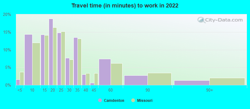
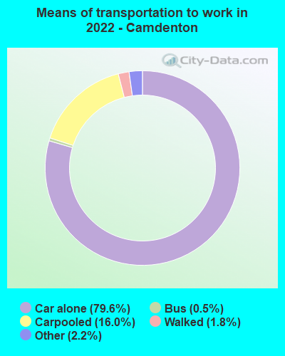
- Mean travel time to work (commute): 15.7 minutes


| Here: | 9.6 |
| Missouri average: | 11.1 |
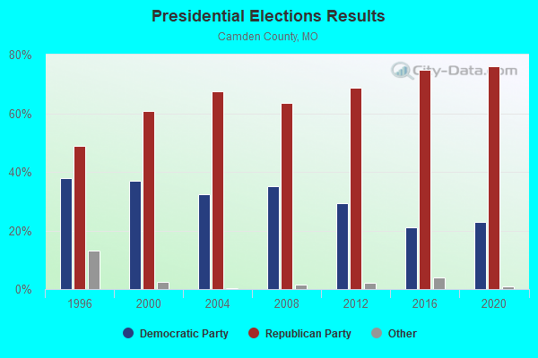
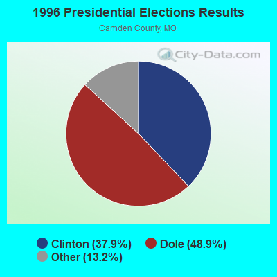
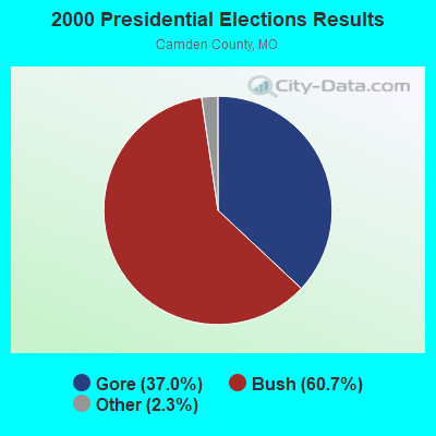
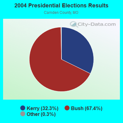
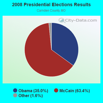
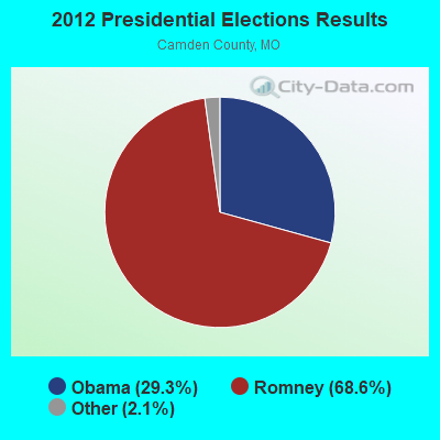

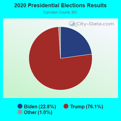
Graphs represent county-level data. Detailed 2008 Election Results
Religion statistics for Camdenton, MO (based on Camden County data)
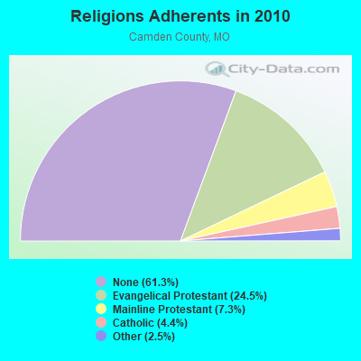
| Religion | Adherents | Congregations |
|---|---|---|
| Evangelical Protestant | 10,799 | 50 |
| Mainline Protestant | 3,211 | 12 |
| Catholic | 1,950 | 2 |
| Other | 1,085 | 5 |
| None | 26,957 | - |
Food Environment Statistics:
| Camden County: | 1.48 / 10,000 pop. |
| Missouri: | 1.88 / 10,000 pop. |
| This county: | 0.25 / 10,000 pop. |
| State: | 0.18 / 10,000 pop. |
| Camden County: | 0.74 / 10,000 pop. |
| Missouri: | 0.60 / 10,000 pop. |
| Camden County: | 7.18 / 10,000 pop. |
| Missouri: | 4.34 / 10,000 pop. |
| This county: | 24.75 / 10,000 pop. |
| Missouri: | 7.37 / 10,000 pop. |
| Here: | 9.5% |
| Missouri: | 8.8% |
| Camden County: | 29.0% |
| Missouri: | 29.6% |
| Here: | 10.8% |
| Missouri: | 13.5% |
Health and Nutrition:
| Camdenton: | 47.7% |
| Missouri: | 50.9% |
| This city: | 44.8% |
| State: | 48.6% |
| Here: | 29.0 |
| Missouri: | 28.7 |
| Camdenton: | 24.2% |
| State: | 20.6% |
| Camdenton: | 10.9% |
| Missouri: | 10.1% |
| This city: | 6.8 |
| Missouri: | 6.8 |
| This city: | 35.0% |
| Missouri: | 34.3% |
| This city: | 54.8% |
| Missouri: | 57.5% |
| Camdenton: | 77.7% |
| State: | 79.3% |
More about Health and Nutrition of Camdenton, MO Residents
| Local government employment and payroll (March 2022) | |||||
| Function | Full-time employees | Monthly full-time payroll | Average yearly full-time wage | Part-time employees | Monthly part-time payroll |
|---|---|---|---|---|---|
| Police Protection - Officers | 15 | $51,168 | $40,934 | 1 | $833 |
| Streets and Highways | 7 | $20,602 | $35,318 | 0 | $0 |
| Parks and Recreation | 4 | $11,660 | $34,980 | 0 | $0 |
| Water Supply | 4 | $10,482 | $31,446 | 0 | $0 |
| Sewerage | 3 | $10,057 | $40,228 | 0 | $0 |
| Financial Administration | 3 | $9,127 | $36,508 | 0 | $0 |
| Police - Other | 2 | $6,107 | $36,642 | 0 | $0 |
| Other Government Administration | 2 | $12,015 | $72,090 | 0 | $0 |
| Other and Unallocable | 2 | $6,696 | $40,176 | 0 | $0 |
| Judicial and Legal | 1 | $3,109 | $37,308 | 0 | $0 |
| Totals for Government | 43 | $141,023 | $39,355 | 1 | $833 |
Camdenton government finances - Expenditure in 2017 (per resident):
- Construction - Parks and Recreation: $266,000 ($65.74)
Regular Highways: $219,000 ($54.13)
Electric Utilities: $15,000 ($3.71)
- Current Operations - Police Protection: $1,088,000 ($268.91)
Regular Highways: $705,000 ($174.25)
Water Utilities: $697,000 ($172.27)
Central Staff Services: $528,000 ($130.50)
Sewerage: $494,000 ($122.10)
Local Fire Protection: $293,000 ($72.42)
Parks and Recreation: $283,000 ($69.95)
Electric Utilities: $121,000 ($29.91)
General - Other: $4,000 ($0.99)
Miscellaneous Commercial Activities - Other: $2,000 ($0.49)
- Intergovernmental to Local - Other - Corrections: $53,000 ($13.10)
- Other Capital Outlay - Electric Utilities: $737,000 ($182.16)
Regular Highways: $74,000 ($18.29)
Police Protection: $59,000 ($14.58)
Local Fire Protection: $46,000 ($11.37)
Parks and Recreation: $41,000 ($10.13)
Sewerage: $3,000 ($0.74)
Water Utilities: $1,000 ($0.25)
Camdenton government finances - Revenue in 2017 (per resident):
- Charges - Sewerage: $427,000 ($105.54)
Parks and Recreation: $60,000 ($14.83)
Other: $23,000 ($5.68)
- Federal Intergovernmental - Air Transportation: $677,000 ($167.33)
- Local Intergovernmental - Electric Utilities: $145,000 ($35.84)
Other: $107,000 ($26.45)
Gas Utilities: $12,000 ($2.97)
- Miscellaneous - Rents: $121,000 ($29.91)
Fines and Forfeits: $79,000 ($19.53)
Interest Earnings: $34,000 ($8.40)
Donations From Private Sources: $6,000 ($1.48)
Sale of Property: $4,000 ($0.99)
- Revenue - Water Utilities: $518,000 ($128.03)
- State Intergovernmental - Highways: $174,000 ($43.01)
- Tax - General Sales and Gross Receipts: $3,339,000 ($825.26)
Property: $78,000 ($19.28)
Public Utilities Sales: $74,000 ($18.29)
Occupation and Business License - Other: $24,000 ($5.93)
Alcoholic Beverage License: $13,000 ($3.21)
Camdenton government finances - Debt in 2017 (per resident):
- Long Term Debt - Beginning Outstanding - Unspecified Public Purpose: $1,555,000 ($384.33)
Outstanding Unspecified Public Purpose: $1,397,000 ($345.28)
Beginning Outstanding - Public Debt for Private Purpose: $450,000 ($111.22)
Outstanding Nonguaranteed - Industrial Revenue: $380,000 ($93.92)
Retired Unspecified Public Purpose: $271,000 ($66.98)
Issue, Unspecified Public Purpose: $113,000 ($27.93)
Retired Nonguaranteed - Public Debt for Private Purpose: $70,000 ($17.30)
Camdenton government finances - Cash and Securities in 2017 (per resident):
- Other Funds - Cash and Securities: $6,799,000 ($1680.43)
- Sinking Funds - Cash and Securities: $380,000 ($93.92)
| Businesses in Camdenton, MO | ||||
| Name | Count | Name | Count | |
|---|---|---|---|---|
| AT&T | 1 | Pizza Hut | 1 | |
| Big O Tires | 1 | RadioShack | 1 | |
| Chevrolet | 1 | SONIC Drive-In | 1 | |
| Curves | 1 | Sleep Inn | 1 | |
| Dairy Queen | 1 | Subway | 2 | |
| FedEx | 2 | T-Mobile | 1 | |
| Ford | 1 | Taco Bell | 1 | |
| H&R Block | 1 | U-Haul | 2 | |
| KFC | 1 | U.S. Cellular | 1 | |
| Kroger | 1 | UPS | 3 | |
| MasterBrand Cabinets | 11 | Walmart | 1 | |
| McDonald's | 1 | |||
Strongest AM radio stations in Camdenton:
- KRMS (1150 AM; 10 kW; OSAGE BEACH, MO; Owner: VIPER COMMUNICATIONS, INC)
- KBNN (750 AM; daytime; 5 kW; LEBANON, MO; Owner: OZARK BROADCASTING, INC.)
- WHB (810 AM; 50 kW; KANSAS CITY, MO; Owner: UNION BROADCASTING, INC.)
- KJPW (1390 AM; 5 kW; WAYNESVILLE, MO; Owner: PULASKI COUNTY BROADCASTERS, INC.)
- KWOS (950 AM; 5 kW; JEFFERSON CITY, MO; Owner: ZIMMER RADIO OF MID-MISSOURI, INC.)
- KXEN (1010 AM; 50 kW; FESTUS-ST. LOUIS, MO; Owner: BDJ RADIO ENTERPRISES, LLC)
- KMOX (1120 AM; 50 kW; ST. LOUIS, MO; Owner: INFINITY BROADCASTING OPERATIONS, INC.)
- KLIK (1240 AM; 5 kW; JEFFERSON CITY, MO; Owner: PREMIER RADIO GROUP)
- KLWT (1230 AM; 1 kW; LEBANON, MO; Owner: PEARSON BROADCASTING OF LEBANON, INC.)
- KMRF (1510 AM; daytime; 5 kW; MARSHFIELD, MO; Owner: NEW LIFE EVANGELISTIC CENTER, INC.)
- KWTO (560 AM; 5 kW; SPRINGFIELD, MO; Owner: KWTO, INC.)
- KKHK (1250 AM; 25 kW; KANSAS CITY, KS)
- KRMG (740 AM; 50 kW; TULSA, OK; Owner: CXR HOLDINGS, INC.)
Strongest FM radio stations in Camdenton:
- KCVO-FM (91.7 FM; CAMDENTON, MO; Owner: LAKE AREA EDUCATIONAL BROADCASTING FOUNDATION)
- KRMS-FM (93.5 FM; OSAGE BEACH, MO; Owner: VIPER COMMUNICATIONS, INC.)
- KJEL (103.7 FM; LEBANON, MO; Owner: OZARK BROADCASTING, INC.)
- K285ER (104.9 FM; OSAGE BEACH, MO; Owner: BD OF GOVERNORS, CENTRAL MO ST. U.)
- KQUL (102.7 FM; LAKE OZARK, MO; Owner: BENNE B/CO CO. OF LAKE OZARK,INC)
- KCLQ (107.9 FM; LEBANON, MO; Owner: PEARSON BROADCASTING OF LEBANON, INC.)
- KLOZ (92.7 FM; ELDON, MO; Owner: BENNE BROADCASTING COMPANY, LLC)
- KFBD-FM (97.9 FM; WAYNESVILLE, MO; Owner: FIDELITY BROADCASTING, INC.)
- KTXY (106.9 FM; JEFFERSON CITY, MO; Owner: ZIMMER RADIO OF MID-MISSOURI, INC.)
- KTTK (90.7 FM; LEBANON, MO; Owner: LEBANON EDUCATIONAL BROADCASTING FOUNDATION)
- KTKS (95.1 FM; VERSAILLES, MO; Owner: TWIN LAKES COMMUNICATIONS, INC.)
- KCRL (90.3 FM; SUNRISE BEACH, MO; Owner: COMMUNITY BROADCASTING INC)
TV broadcast stations around Camdenton:
- K64FQ (Channel 64; LEBANON, MO; Owner: NEW LIFE EVANGELISTIC CENTER, INC.)
- KMOS-TV (Channel 6; SEDALIA, MO; Owner: BOARD OF GOVERNORS OF CENTRAL MISSOURI STATE UNIVERSITY)
- KYTV (Channel 3; SPRINGFIELD, MO; Owner: KY3, INC.)
- KSPR (Channel 33; SPRINGFIELD, MO; Owner: PIEDMONT TELEVISION OF SPRINGFIELD LICENSE LLC)
- KOZK (Channel 21; SPRINGFIELD, MO; Owner: BD. OF GOVERNORS OF SW MISSOURI STATE UNIVERSITY)
- KOLR (Channel 10; SPRINGFIELD, MO; Owner: VHR SPRINGFIELD LICENSE, INC.)
- KDEB-TV (Channel 27; SPRINGFIELD, MO; Owner: QUORUM OF MISSOURI LICENSE, LLC)

- National Bridge Inventory (NBI) Statistics
- 26Number of bridges
- 502ft / 153mTotal length
- $375,000Total costs
- 168,956Total average daily traffic
- 21,633Total average daily truck traffic

- New bridges - historical statistics
- 11910-1919
- 11960-1969
- 21970-1979
- 11990-1999
- 192000-2009
- 12010-2019
- 12020-2022
FCC Registered Antenna Towers: 176 (See the full list of FCC Registered Antenna Towers)
FCC Registered Private Land Mobile Towers: 1 (See the full list of FCC Registered Private Land Mobile Towers in Camdenton, MO)
FCC Registered Broadcast Land Mobile Towers: 20 (See the full list of FCC Registered Broadcast Land Mobile Towers)
FCC Registered Microwave Towers: 23 (See the full list of FCC Registered Microwave Towers in this town)
FCC Registered Maritime Coast & Aviation Ground Towers: 2 (See the full list of FCC Registered Maritime Coast & Aviation Ground Towers)
FCC Registered Amateur Radio Licenses: 105 (See the full list of FCC Registered Amateur Radio Licenses in Camdenton)
FAA Registered Aircraft Manufacturers and Dealers: 7 (See the full list of FAA Registered Manufacturers and Dealers in Camdenton)
FAA Registered Aircraft: 16 (See the full list of FAA Registered Aircraft)
2002 - 2018 National Fire Incident Reporting System (NFIRS) incidents
- Fire incident types reported to NFIRS in Camdenton, MO
- 1,14159.9%Outside Fires
- 46724.5%Structure Fires
- 1759.2%Mobile Property/Vehicle Fires
- 1226.4%Other
 Based on the data from the years 2002 - 2018 the average number of fire incidents per year is 112. The highest number of fire incidents - 253 took place in 2017, and the least - 29 in 2010. The data has a declining trend.
 When looking into fire subcategories, the most reports belonged to: Outside Fires (59.9%), and Structure Fires (24.5%).
| Most common first names in Camdenton, MO among deceased individuals | ||
| Name | Count | Lived (average) |
|---|---|---|
| John | 89 | 75.2 years |
| William | 84 | 74.9 years |
| James | 78 | 69.4 years |
| Mary | 72 | 80.4 years |
| Charles | 61 | 72.8 years |
| Robert | 59 | 72.6 years |
| George | 49 | 79.1 years |
| Dorothy | 43 | 79.6 years |
| Helen | 34 | 82.6 years |
| Edward | 33 | 70.7 years |
| Most common last names in Camdenton, MO among deceased individuals | ||
| Last name | Count | Lived (average) |
|---|---|---|
| Jones | 30 | 74.1 years |
| Wilson | 25 | 72.0 years |
| Johnson | 24 | 77.8 years |
| Webster | 21 | 70.3 years |
| Smith | 21 | 75.4 years |
| Burns | 21 | 71.4 years |
| Rogers | 20 | 74.0 years |
| Miller | 19 | 73.3 years |
| White | 19 | 75.5 years |
| Morgan | 18 | 80.2 years |
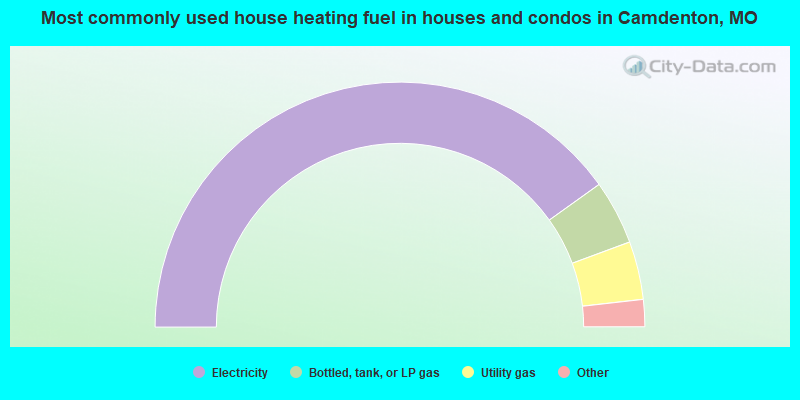
- 80.4%Electricity
- 8.5%Bottled, tank, or LP gas
- 7.7%Utility gas
- 2.0%Wood
- 1.4%Fuel oil, kerosene, etc.
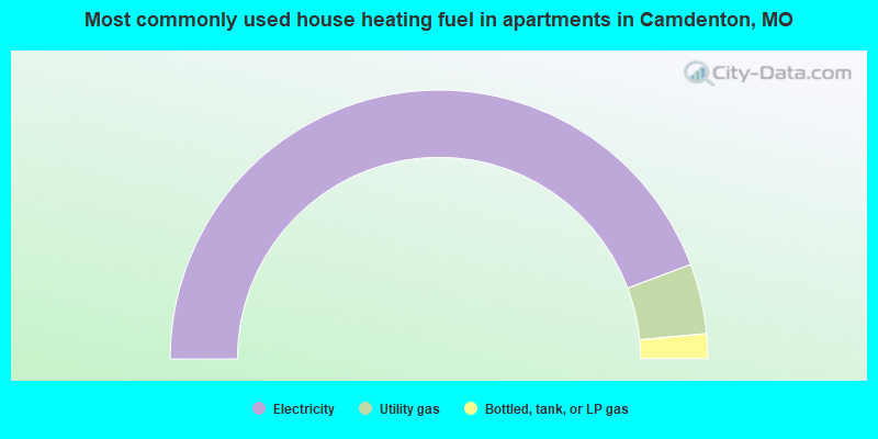
- 88.6%Electricity
- 8.4%Utility gas
- 3.0%Bottled, tank, or LP gas
Camdenton compared to Missouri state average:
- Unemployed percentage below state average.
- Black race population percentage significantly below state average.
- Hispanic race population percentage above state average.
- House age below state average.
- Institutionalized population percentage above state average.
- Percentage of population with a bachelor's degree or higher below state average.

|
|
Total of 25 patent applications in 2008-2024.