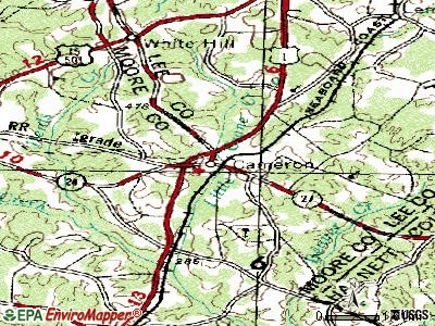
Cameron, North Carolina
Submit your own pictures of this town and show them to the world
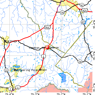
- OSM Map
- General Map
- Google Map
- MSN Map
Population change since 2000: +66.9%
| Males: 105 | |
| Females: 147 |
| Median resident age: | 36.3 years |
| North Carolina median age: | 39.2 years |
Zip code: 28326
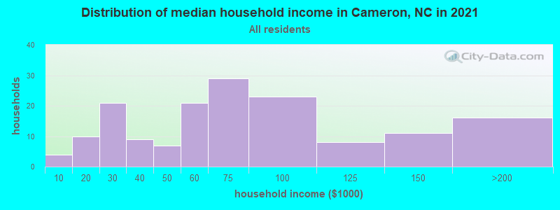
| Cameron: | $78,501 |
| NC: | $67,481 |
Estimated per capita income in 2022: $27,973 (it was $15,337 in 2000)
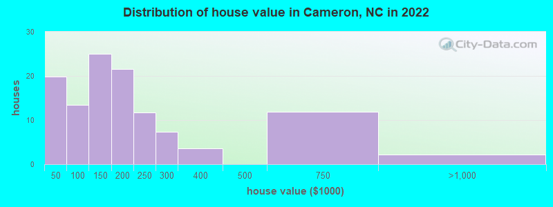
Estimated median house or condo value in 2022: $186,817 (it was $60,000 in 2000)
| Cameron: | $186,817 |
| NC: | $280,600 |
Mean prices in 2022: all housing units: $206,975; detached houses: $234,324; mobile homes: $34,853
Median gross rent in 2022: $891.
(5.1% for White Non-Hispanic residents, 41.7% for Hispanic or Latino residents, 100.0% for other race residents, 87.5% for two or more races residents)
Detailed information about poverty and poor residents in Cameron, NC

Compare current foreclosures near Cameron, NC:
| Photo | Address | Area | Beds / Baths | Price | Details |
|---|---|---|---|---|---|

|
#1
Pilson Rd
Cameron, NC 28326
|
1,620 sq. feet
|
2 baths 3 beds |
show details | |

|
#2
Sellars Rd
Cameron, NC 28326
|
1,456 sq. feet
|
2 baths 3 beds |
show details | |

|
#3
Lexington Ln
Cameron, NC 28326
|
- sq. feet
|
2 baths 3 beds |
show details | |

|
#4
Roping Ln
Cameron, NC 28326
|
- sq. feet
|
2 baths 3 beds |
show details | |

|
#5
Fox Run
Cameron, NC 28326
|
- sq. feet
|
2 baths 3 beds |
show details | |

|
#6
Patriots Way
Cameron, NC 28326
|
- sq. feet
|
2 baths 3 beds |
show details | |

|
#7
Virginia Ln
Cameron, NC 28326
|
- sq. feet
|
2 baths 3 beds |
show details | |

|
#8
Chesapeake Rd
Cameron, NC 28326
|
- sq. feet
|
2 baths 3 beds |
show details | |

|
#9
Forest Dr
Cameron, NC 28326
|
- sq. feet
|
2 baths 3 beds |
show details | |

|
#10
Culpepper Rd
Cameron, NC 28326
|
- sq. feet
|
2 baths 3 beds |
show details |
| Photo | Address | Area | Beds / Baths | Price | Details |
|---|---|---|---|---|---|

|
#11
Revolutionary Rd
Cameron, NC 28326
|
- sq. feet
|
- baths - beds |
show details | |

|
#12
Century Dr
Cameron, NC 28326
|
- sq. feet
|
- baths - beds |
show details | |

|
#13
Century Dr
Cameron, NC 28326
|
- sq. feet
|
- baths - beds |
show details | |

|
#14
Wolfpack Ln
Cameron, NC 28326
|
- sq. feet
|
- baths - beds |
show details | |

|
#15
Culpepper Rd
Cameron, NC 28326
|
- sq. feet
|
- baths - beds |
show details | |

|
#16
Brookstone Dr
Cameron, NC 28326
|
- sq. feet
|
- baths - beds |
show details | |

|
#17
Atlantic Coast St
Cameron, NC 28326
|
- sq. feet
|
- baths - beds |
show details | |

|
#18
Seahawk Ave
Cameron, NC 28326
|
- sq. feet
|
- baths - beds |
show details | |

|
#19
Pine Oak
Cameron, NC 28326
|
- sq. feet
|
- baths - beds |
show details | |

|
#20
Brooks Mangum Rd
Cameron, NC 28326
|
- sq. feet
|
- baths - beds |
show details |
| Photo | Address | Area | Beds / Baths | Price | Details |
|---|---|---|---|---|---|

|
#21
Buckeye Pl
Cameron, NC 28326
|
- sq. feet
|
- baths - beds |
show details | |

|
#22
Brookstone Dr
Cameron, NC 28326
|
- sq. feet
|
- baths - beds |
show details | |

|
#23
Cypress Rd
Cameron, NC 28326
|
- sq. feet
|
- baths - beds |
show details | |

|
#24
Oakwater Dr
Cameron, NC 28326
|
- sq. feet
|
- baths - beds |
show details | |

|
#25
Line Rd
Cameron, NC 28326
|
- sq. feet
|
- baths - beds |
show details | |

|
#26
Trenton Pl
Cameron, NC 28326
|
- sq. feet
|
- baths - beds |
show details | |

|
#27
Hillmon Grove Rd
Cameron, NC 28326
|
- sq. feet
|
- baths - beds |
show details | |

|
#28
Stanton Hill Rd
Cameron, NC 28326
|
- sq. feet
|
- baths - beds |
show details | |

|
#29
Rothney Ave
Southern Pines, NC 28387
|
1,050 sq. feet
|
1 baths 3 beds |
show details | |

|
#30
Brookfield Cir
Sanford, NC 27330
|
1,279 sq. feet
|
2 baths 3 beds |
show details |
| Photo | Address | Area | Beds / Baths | Price | Details |
|---|---|---|---|---|---|

|
#31
Upland Reach
Sanford, NC 27332
|
1,282 sq. feet
|
2 baths 3 beds |
show details | |

|
#32
Timuquana Trl
Pinehurst, NC 28374
|
2,309 sq. feet
|
3 baths 3 beds |
show details | |

|
#33
Old Hunt Pl
Pinehurst, NC 28374
|
1,520 sq. feet
|
2 baths 3 beds |
show details | |

|
#34
S Kirby Ln
Sanford, NC 27330
|
1,782 sq. feet
|
2 baths 3 beds |
show details | |

|
#35
S Carlisle St
Southern Pines, NC 28387
|
1,512 sq. feet
|
2 baths 3 beds |
show details | |

|
#36
Cherokee Trl
Sanford, NC 27332
|
1,336 sq. feet
|
2 baths 3 beds |
show details | |

|
#37
Willow Ridge Dr
Sanford, NC 27332
|
2,188 sq. feet
|
2 baths 4 beds |
show details | |

|
#38
Willow Ridge Dr
Sanford, NC 27332
|
2,188 sq. feet
|
2 baths 4 beds |
show details | |

|
#39
Beal Dr
Sanford, NC 27330
|
1,120 sq. feet
|
1 baths 2 beds |
show details | |

|
#40
Autumn Dr
Vass, NC 28394
|
1,792 sq. feet
|
2 baths 3 beds |
show details |
| Photo | Address | Area | Beds / Baths | Price | Details |
|---|---|---|---|---|---|

|
#41
Taton Ct
Sanford, NC 27330
|
2,373 sq. feet
|
2 baths 4 beds |
show details | |

|
#42
E Chisholm St
Sanford, NC 27330
|
1,092 sq. feet
|
1 baths 3 beds |
show details | |

|
#43
Barber Rd
Carthage, NC 28327
|
1,620 sq. feet
|
2 baths 3 beds |
show details | |

|
#44
Garden Villa Dr
Pinehurst, NC 28374
|
1,342 sq. feet
|
2 baths 3 beds |
show details | |

|
#45
Wright Rd
Vass, NC 28394
|
2,052 sq. feet
|
2 baths 3 beds |
show details | |

|
#46
W Garden St
Sanford, NC 27330
|
1,066 sq. feet
|
1 baths 2 beds |
show details | |

|
#47
Landor Cir
Sanford, NC 27330
|
1,968 sq. feet
|
2 baths 4 beds |
show details | |

|
#48
N Franklin Dr
Sanford, NC 27330
|
1,396 sq. feet
|
2 baths 3 beds |
show details | |

|
#49
Boykin Ave
Sanford, NC 27330
|
1,526 sq. feet
|
2 baths 4 beds |
show details | |

|
Check over 1 million property listings on Foreclosure.com!
|
browse all offers | |||


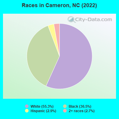
- 24755.3%White alone
- 16336.5%Black alone
- 132.9%Hispanic
- 122.7%Two or more races
According to our research of North Carolina and other state lists, there were 46 registered sex offenders living in Cameron, North Carolina as of May 17, 2024.
The ratio of all residents to sex offenders in Cameron is 6 to 1.
 Recent articles from our blog. Our writers, many of them Ph.D. graduates or candidates, create easy-to-read articles on a wide variety of topics.


Latest news from Cameron, NC collected exclusively by city-data.com from local newspapers, TV, and radio stations
Ancestries: Scottish (9.4%), English (8.5%), American (4.1%), German (4.1%), Scotch-Irish (1.6%), Irish (1.3%).
Current Local Time: EST time zone
Elevation: 340 feet
Land area: 1.05 square miles.
Population density: 240 people per square mile (very low).

2 residents are foreign born
| This town: | 0.4% |
| North Carolina: | 8.3% |
| Cameron town: | 0.8% ($460) |
| North Carolina: | 0.9% ($826) |
Nearest city with pop. 50,000+: Fayetteville, NC  (26.1 miles , pop. 121,015).
Nearest city with pop. 200,000+: Raleigh, NC (48.3 miles , pop. 276,093).
Nearest city with pop. 1,000,000+: Philadelphia, PA (393.6 miles , pop. 1,517,550).
Nearest cities:
), ), )Latitude: 35.33 N, Longitude: 79.25 W
Area code commonly used in this area: 910

| Here: | 3.1% |
| North Carolina: | 3.2% |
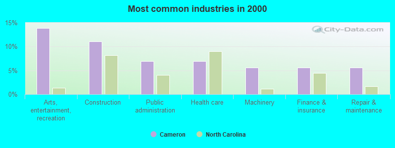
- Arts, entertainment, recreation (13.9%)
- Construction (11.1%)
- Public administration (6.9%)
- Health care (6.9%)
- Machinery (5.6%)
- Finance & insurance (5.6%)
- Repair & maintenance (5.6%)

- Construction (18.9%)
- Arts, entertainment, recreation (16.2%)
- Repair & maintenance (10.8%)
- Motor vehicle & parts dealers (8.1%)
- Chemicals (8.1%)
- Public administration (8.1%)
- Lumber & other construction materials merchant wholesalers (5.4%)
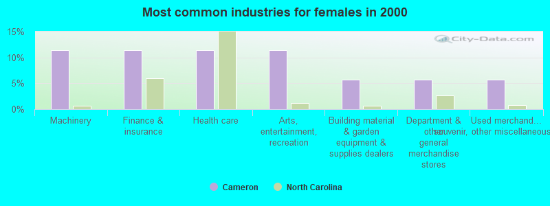
- Machinery (11.4%)
- Finance & insurance (11.4%)
- Health care (11.4%)
- Arts, entertainment, recreation (11.4%)
- Building material & garden equipment & supplies dealers (5.7%)
- Department & other general merchandise stores (5.7%)
- Used merchandise, gift, novelty, souvenir, other miscellaneous stores (5.7%)
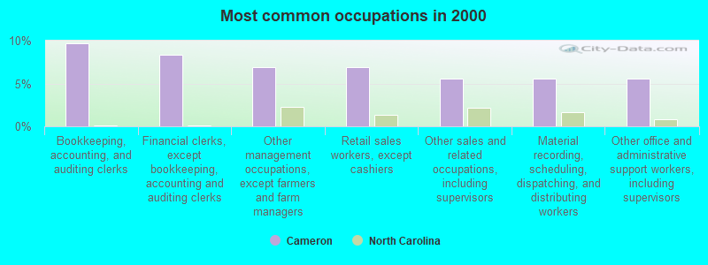
- Bookkeeping, accounting, and auditing clerks (9.7%)
- Financial clerks, except bookkeeping, accounting and auditing clerks (8.3%)
- Other management occupations, except farmers and farm managers (6.9%)
- Retail sales workers, except cashiers (6.9%)
- Other sales and related occupations, including supervisors (5.6%)
- Material recording, scheduling, dispatching, and distributing workers (5.6%)
- Other office and administrative support workers, including supervisors (5.6%)
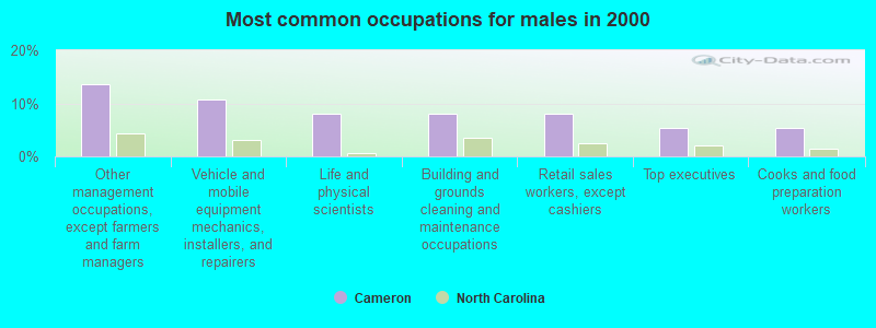
- Other management occupations, except farmers and farm managers (13.5%)
- Vehicle and mobile equipment mechanics, installers, and repairers (10.8%)
- Life and physical scientists (8.1%)
- Building and grounds cleaning and maintenance occupations (8.1%)
- Retail sales workers, except cashiers (8.1%)
- Top executives (5.4%)
- Cooks and food preparation workers (5.4%)
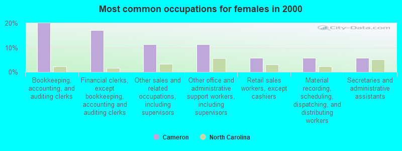
- Bookkeeping, accounting, and auditing clerks (20.0%)
- Financial clerks, except bookkeeping, accounting and auditing clerks (17.1%)
- Other sales and related occupations, including supervisors (11.4%)
- Other office and administrative support workers, including supervisors (11.4%)
- Retail sales workers, except cashiers (5.7%)
- Material recording, scheduling, dispatching, and distributing workers (5.7%)
- Secretaries and administrative assistants (5.7%)
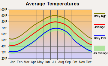
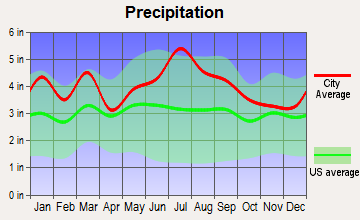
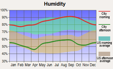
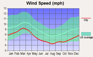
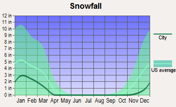
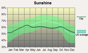
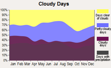
Average climate in Cameron, North Carolina
Based on data reported by over 4,000 weather stations
(lower is better)
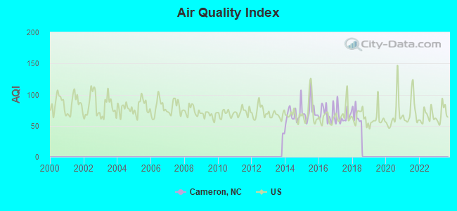
Air Quality Index (AQI) level in 2018 was 58.5. This is better than average.
| City: | 58.5 |
| U.S.: | 72.6 |
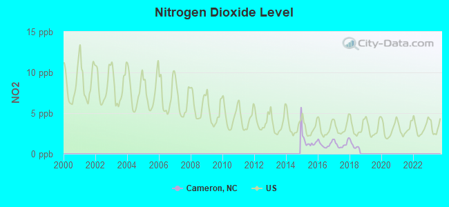
Nitrogen Dioxide (NO2) [ppb] level in 2018 was 1.01. This is significantly better than average. Closest monitor was 7.6 miles away from the city center.
| City: | 1.01 |
| U.S.: | 5.11 |
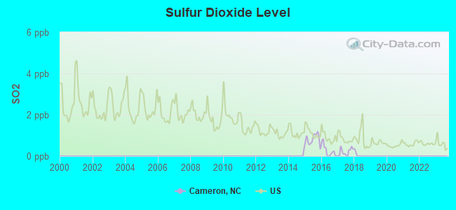
Sulfur Dioxide (SO2) [ppb] level in 2018 was 0.0848. This is significantly better than average. Closest monitor was 7.6 miles away from the city center.
| City: | 0.0848 |
| U.S.: | 1.5147 |
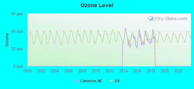
Ozone [ppb] level in 2018 was 33.6. This is about average. Closest monitor was 7.6 miles away from the city center.
| City: | 33.6 |
| U.S.: | 33.3 |
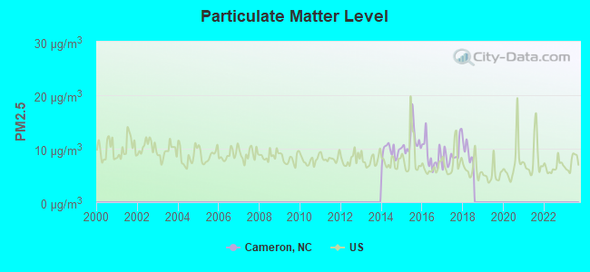
Particulate Matter (PM2.5) [µg/m3] level in 2018 was 9.29. This is about average. Closest monitor was 7.6 miles away from the city center.
| City: | 9.29 |
| U.S.: | 8.11 |
Tornado activity:
Cameron-area historical tornado activity is slightly above North Carolina state average. It is 4% greater than the overall U.S. average.
On 3/28/1984, a category F4 (max. wind speeds 207-260 mph) tornado 34.6 miles away from the Cameron town center killed 4 people and injured 395 people and caused between $5,000,000 and $50,000,000 in damages.
On 2/22/1971, a category F3 (max. wind speeds 158-206 mph) tornado 25.4 miles away from the town center killed 2 people and injured 60 people and caused between $500,000 and $5,000,000 in damages.
Earthquake activity:
Cameron-area historical earthquake activity is significantly above North Carolina state average. It is 46% smaller than the overall U.S. average.On 8/23/2011 at 17:51:04, a magnitude 5.8 (5.8 MW, Depth: 3.7 mi, Class: Moderate, Intensity: VI - VII) earthquake occurred 193.1 miles away from Cameron center
On 8/9/2020 at 12:07:37, a magnitude 5.1 (5.1 MW, Depth: 4.7 mi) earthquake occurred 130.2 miles away from Cameron center
On 8/2/1974 at 08:52:09, a magnitude 4.9 (4.3 MB, 4.9 LG, Class: Light, Intensity: IV - V) earthquake occurred 209.8 miles away from the city center
On 11/22/1974 at 05:25:55, a magnitude 4.7 (4.7 MB) earthquake occurred 175.4 miles away from the city center
On 12/9/2003 at 20:59:14, a magnitude 4.5 (4.5 MB, 4.5 LG) earthquake occurred 173.5 miles away from the city center
On 12/9/2003 at 20:59:18, a magnitude 4.5 (4.5 ML, Depth: 6.2 mi) earthquake occurred 181.0 miles away from the city center
Magnitude types: regional Lg-wave magnitude (LG), body-wave magnitude (MB), local magnitude (ML), moment magnitude (MW)
Natural disasters:
The number of natural disasters in Moore County (14) is near the US average (15).Major Disasters (Presidential) Declared: 7
Emergencies Declared: 5
Causes of natural disasters: Hurricanes: 7, Droughts: 2, Ice Storms: 2, Blizzard: 1, Freeze: 1, Winter Storm: 1, Other: 1 (Note: some incidents may be assigned to more than one category).
Hospitals and medical centers near Cameron:
- PINE RIDGE GROUP HOME (Hospital, about 7 miles away; SANFORD, NC)
- PEAK RESOURCES - PINELAKE (Nursing Home, about 10 miles away; CARTHAGE, NC)
- LEE COUNTY NURSING AND REHABILITATION CENTER (Nursing Home, about 10 miles away; SANFORD, NC)
- ST JOSEPH OF THE PINES HEALTH (Nursing Home, about 10 miles away; SOUTHERN PINES, NC)
- SAINT JOSEPH OF THE PINES HEALTHCENTER (Nursing Home, about 10 miles away; SOUTHERN PINES, NC)
- CENTRAL CAROLINA HOSPITAL Acute Care Hospitals (about 11 miles away; SANFORD, NC)
- ST JOSEPH OF THE PINES HOSPITAL (Hospital, about 12 miles away; SOUTHERN PINES, NC)
Airports located in Cameron:
- Dean Wings Past Airport (8NC1) (Runways: 1)
- Rooster Field Airport (84NC) (Runways: 1)
Colleges/universities with over 2000 students nearest to Cameron:
- Central Carolina Community College (about 12 miles; Sanford, NC; Full-time enrollment: 3,675)
- Sandhills Community College (about 12 miles; Pinehurst, NC; FT enrollment: 3,434)
- Methodist University (about 26 miles; Fayetteville, NC; FT enrollment: 2,313)
- Fayetteville Technical Community College (about 26 miles; Fayetteville, NC; FT enrollment: 10,114)
- Fayetteville State University (about 27 miles; Fayetteville, NC; FT enrollment: 5,297)
- Campbell University (about 30 miles; Buies Creek, NC; FT enrollment: 5,127)
- Wake Technical Community College (about 39 miles; Raleigh, NC; FT enrollment: 16,265)
Public high school in Cameron:
- UNION PINES HIGH (Location: 1981 UNION CHURCH RD, Grades: 9-12)
Private high school in Cameron:
Public elementary/middle schools in Cameron:
- JOHNSONVILLE ELEMENTARY (Location: 18495 NC HWY 27 WEST, Grades: KG-5)
- CAMERON ELEMENTARY (Location: 2636 NC HWY 24 27, Grades: KG-5)
- NEW CENTURY MIDDLE (Location: 1577 UNION CHURCH ROAD, Grades: 6-8)
Points of interest:
Church in Cameron: Hood Chapel (A). Display/hide its location on the map
Birthplace of: Jeff Hardy - Professional wrestler and musician, Matt Hardy - Professional wrestler, Shannon Moore - Professional wrestler.
Drinking water stations with addresses in Cameron and their reported violations in the past:
CAMERON, TOWN OF (Population served: 490, Groundwater):Past monitoring violations:CAMERON BOYS CAMP (Population served: 75, Groundwater):
- Monitoring and Reporting (DBP) - Between JAN-2005 and DEC-2005, Contaminant: Total Haloacetic Acids (HAA5). Follow-up actions: St Public Notif requested (JUN-20-2006), St Formal NOV issued (JUN-20-2006), St Compliance achieved (SEP-14-2006)
- Monitoring and Reporting (DBP) - Between JAN-2005 and DEC-2005, Contaminant: TTHM. Follow-up actions: St Public Notif requested (JUN-20-2006), St Formal NOV issued (JUN-20-2006), St Compliance achieved (SEP-14-2006)
- 168 regular monitoring violations
Past monitoring violations:
- Follow-up Or Routine LCR Tap M/R - In OCT-01-2010, Contaminant: Lead and Copper Rule. Follow-up actions: St Public Notif requested (APR-04-2011), St Formal NOV issued (APR-04-2011), St AO (w/o penalty) issued (APR-04-2011), St Public Notif received (APR-13-2011), St Compliance achieved (AUG-21-2013)
| This town: | 2.5 people |
| North Carolina: | 2.5 people |
| This town: | 65.5% |
| Whole state: | 66.7% |
| This town: | 2.6% |
| Whole state: | 5.9% |
Likely homosexual households (counted as self-reported same-sex unmarried-partner households)
- Lesbian couples: 0.0% of all households
- Gay men: 0.9% of all households
For population 15 years and over in Cameron:
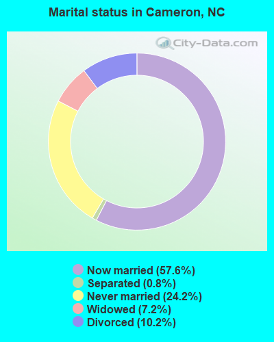
- Never married: 24.2%
- Now married: 57.6%
- Separated: 0.8%
- Widowed: 7.2%
- Divorced: 10.2%
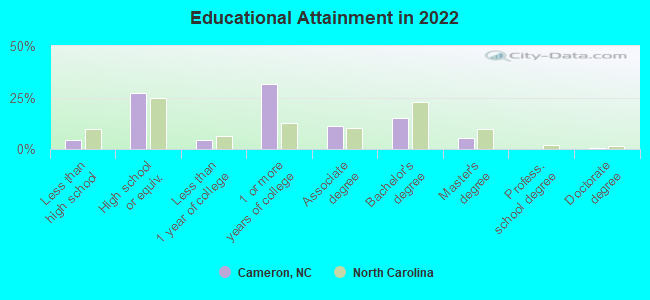
For population 25 years and over in Cameron:
- High school or higher: 93.6%
- Bachelor's degree or higher: 22.3%
- Graduate or professional degree: 7.4%
- Unemployed: 8.9%
- Mean travel time to work (commute): 21.8 minutes
| Here: | 7.7 |
| North Carolina average: | 11.7 |

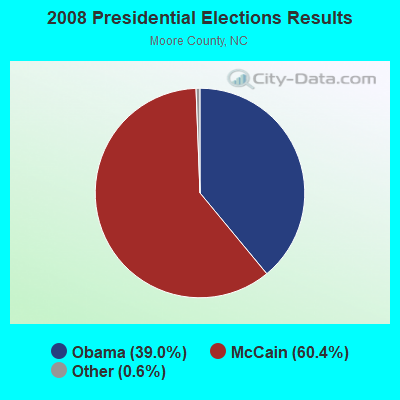
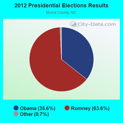
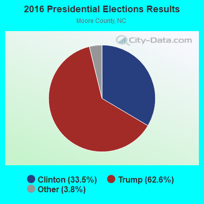
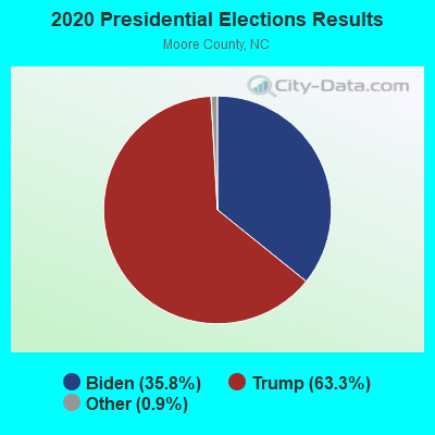
Graphs represent county-level data. Detailed 2008 Election Results
Religion statistics for Cameron, NC (based on Moore County data)
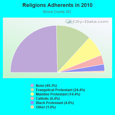
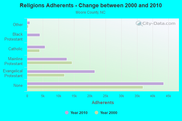
| Religion | Adherents | Congregations |
|---|---|---|
| Evangelical Protestant | 21,490 | 89 |
| Mainline Protestant | 12,675 | 49 |
| Catholic | 5,653 | 3 |
| Black Protestant | 4,072 | 25 |
| Other | 875 | 4 |
| None | 43,482 | - |
Food Environment Statistics:
| This county: | 1.78 / 10,000 pop. |
| State: | 2.05 / 10,000 pop. |
| Moore County: | 0.12 / 10,000 pop. |
| North Carolina: | 0.14 / 10,000 pop. |
| Moore County: | 0.95 / 10,000 pop. |
| State: | 0.92 / 10,000 pop. |
| Here: | 4.28 / 10,000 pop. |
| North Carolina: | 4.75 / 10,000 pop. |
| Here: | 9.86 / 10,000 pop. |
| North Carolina: | 7.57 / 10,000 pop. |
| Moore County: | 10.2% |
| North Carolina: | 9.8% |
| Here: | 24.1% |
| State: | 28.3% |
| Here: | 16.7% |
| North Carolina: | 15.6% |
Health and Nutrition:
| Cameron: | 53.6% |
| State: | 48.9% |
| Cameron: | 52.7% |
| State: | 46.1% |
| This city: | 28.8 |
| North Carolina: | 28.8 |
| This city: | 16.6% |
| North Carolina: | 20.7% |
| Cameron: | 10.6% |
| State: | 10.7% |
| This city: | 6.7 |
| North Carolina: | 6.8 |
| Here: | 36.4% |
| North Carolina: | 33.7% |
| Cameron: | 58.3% |
| North Carolina: | 55.8% |
| Cameron: | 81.1% |
| North Carolina: | 79.7% |
More about Health and Nutrition of Cameron, NC Residents
| Local government employment and payroll (March 2022) | |||||
| Function | Full-time employees | Monthly full-time payroll | Average yearly full-time wage | Part-time employees | Monthly part-time payroll |
|---|---|---|---|---|---|
| Police Protection - Officers | 1 | $3,527 | $42,324 | 0 | $0 |
| Water Supply | 0 | $0 | 1 | $477 | |
| Solid Waste Management | 0 | $0 | 1 | $699 | |
| Streets and Highways | 0 | $0 | 1 | $524 | |
| Financial Administration | 0 | $0 | 1 | $1,586 | |
| Parks and Recreation | 0 | $0 | 1 | $158 | |
| Totals for Government | 1 | $3,527 | $42,324 | 5 | $3,444 |
Cameron government finances - Expenditure in 2017 (per resident):
- Current Operations - Financial Administration: $59,000 ($234.13)
Water Utilities: $59,000 ($234.13)
Police Protection: $55,000 ($218.25)
Solid Waste Management: $35,000 ($138.89)
Regular Highways: $26,000 ($103.17)
Parks and Recreation: $21,000 ($83.33)
Local Fire Protection: $14,000 ($55.56)
- General - Interest on Debt: $1,000 ($3.97)
Cameron government finances - Revenue in 2017 (per resident):
- Charges - Solid Waste Management: $13,000 ($51.59)
Miscellaneous Commercial Activities: $12,000 ($47.62)
- Miscellaneous - Donations From Private Sources: $12,000 ($47.62)
General Revenue - Other: $1,000 ($3.97)
- Revenue - Water Utilities: $81,000 ($321.43)
- State Intergovernmental - General Local Government Support: $18,000 ($71.43)
Highways: $10,000 ($39.68)
- Tax - Property: $103,000 ($408.73)
General Sales and Gross Receipts: $78,000 ($309.52)
Other License: $1,000 ($3.97)
Cameron government finances - Debt in 2017 (per resident):
- Long Term Debt - Beginning Outstanding - Unspecified Public Purpose: $26,000 ($103.17)
Outstanding Unspecified Public Purpose: $17,000 ($67.46)
Retired Unspecified Public Purpose: $9,000 ($35.71)
10.36% of this county's 2021 resident taxpayers lived in other counties in 2020 ($96,288 average adjusted gross income)
| Here: | 10.36% |
| North Carolina average: | 8.85% |
0.21% of residents moved from foreign countries ($1,707 average AGI)
Moore County: 0.21% North Carolina average: 0.04%
Top counties from which taxpayers relocated into this county between 2020 and 2021:
| from Cumberland County, NC | |
| from Harnett County, NC | |
| from Wake County, NC |
7.75% of this county's 2020 resident taxpayers moved to other counties in 2021 ($70,721 average adjusted gross income)
| Here: | 7.75% |
| North Carolina average: | 7.89% |
0.12% of residents moved to foreign countries ($1,343 average AGI)
Moore County: 0.12% North Carolina average: 0.03%
Top counties to which taxpayers relocated from this county between 2020 and 2021:
| to Wake County, NC | |
| to Cumberland County, NC | |
| to Harnett County, NC |
| Businesses in Cameron, NC | ||||
| Name | Count | Name | Count | |
|---|---|---|---|---|
| Advance Auto Parts | 1 | McDonald's | 1 | |
| Dairy Queen | 1 | Subway | 1 | |
| KFC | 1 | Taco Bell | 1 | |
| Kincaid | 1 | U-Haul | 2 | |
Strongest AM radio stations in Cameron:
- WEEB (990 AM; 10 kW; SOUTHERN PINES, NC; Owner: PINEHURST BROADCASTING CORP.)
- WPTF (680 AM; 50 kW; RALEIGH, NC; Owner: FIRST STATE COMMUNICATIONS)
- WFNC (640 AM; 10 kW; FAYETTEVILLE, NC; Owner: CUMULUS LICENSING CORP.)
- WWGP (1050 AM; 1 kW; SANFORD, NC; Owner: WWGP BROADCASTING CORP.)
- WFTK (1030 AM; daytime; 50 kW; WAKE FOREST, NC; Owner: POSITIVE RADIO GROUP, INC.)
- WTRU (830 AM; 50 kW; KERNERSVILLE, NC; Owner: TRUTH BROADCASTING CORPORATION)
- WXKL (1290 AM; 1 kW; SANFORD, NC; Owner: WGSE INCORPORATED)
- WRBZ (850 AM; 10 kW; RALEIGH, NC; Owner: ALCHEMY COMMUNICATIONS LIMITED PARTNERSHIP #1)
- WQNX (1350 AM; 2 kW; ABERDEEN, NC; Owner: GOLF CAPITAL BROADCASTING, INC.)
- WCKB (780 AM; 7 kW; DUNN, NC; Owner: NORTH CAROLINA CENTRAL BROADCASTERS, INC.)
- WLLN (1370 AM; 5 kW; LILLINGTON, NC; Owner: ESTUARDO VALDEMAR RODRIGUEZ)
- WIOZ (550 AM; 1 kW; PINEHURST, NC; Owner: MUIRFIELD BROADCASTING, INC.)
- WBT (1110 AM; 50 kW; CHARLOTTE, NC; Owner: JEFFERSON-PILOT COMMUNICATNS CO. OF NORTH CAROLINA)
Strongest FM radio stations in Cameron:
- WFJA (105.5 FM; SANFORD, NC; Owner: WWGP BROADCASTING CORPORATION)
- WQDR (94.7 FM; RALEIGH, NC; Owner: CAROLINA MEDIA GROUP, INC.)
- WQSM (98.1 FM; FAYETTEVILLE, NC; Owner: CUMULUS LICENSING CORP.)
- WRSN (93.9 FM; BURLINGTON, NC; Owner: CAPSTAR TX LIMITED PARTNERSHIP)
- WUNC (91.5 FM; CHAPEL HILL, NC; Owner: BOARD OF TRUSTEES UNIVERSITY OF NC AT CHAPEL HILL)
- WRAL (101.5 FM; RALEIGH, NC; Owner: WRAL-FM, INC.)
- W290AD (105.9 FM; SOUTHERN PINES, NC; Owner: BIBLE BROADCASTING NETWORK, INC.)
- WIOZ-FM (102.5 FM; SOUTHERN PINES, NC; Owner: MERIDIAN COMMUNICATIONS. L.L.C.)
- WDCG (105.1 FM; DURHAM, NC; Owner: CAPSTAR TX LIMITED PARTNERSHIP)
- WMAG (99.5 FM; HIGH POINT, NC; Owner: CAPSTAR TX LIMITED PARTNERSHIP)
- WFLB (96.5 FM; LAURINBURG, NC; Owner: WFLB LICENSE LIMITED PARTNERSHIP)
- WKML (95.7 FM; LUMBERTON, NC; Owner: WKML LICENSE LIMITED PARTNERSHIP)
- WKXU (101.1 FM; BURLINGTON, NC; Owner: CAROLINA RADIO GROUP, INC.)
- WKQB (106.9 FM; SOUTHERN PINES, NC; Owner: CUMULUS LICENSING CORP)
- WBBB (96.1 FM; RALEIGH, NC; Owner: CAROLINA MEDIA GROUP, INC.)
- WKRR (92.3 FM; ASHEBORO, NC; Owner: DICK BROADCASTING COMPANY, INC. OF TENNESSEE)
- W204AV (88.7 FM; SANFORD, NC; Owner: AMERICAN FAMILY ASSOCIATION)
- WDCC (90.5 FM; SANFORD, NC; Owner: CENTRAL CAROLINA COMMUNITY COLLEGE)
- WBFY (90.3 FM; PINEHURST, NC; Owner: AMERICAN FAMILY ASSOCIATION)
TV broadcast stations around Cameron:
- WUVC (Channel 40; FAYETTEVILLE, NC; Owner: CAPITAL BROADCASTING PARTNERS)
- W67CD (Channel 67; SANFORD, NC; Owner: CENTRAL CAROLINA B/CING. CORP., INC.)
- WRAZ (Channel 50; RALEIGH, NC; Owner: WRAZ-TV, INC.)
- WTVD (Channel 11; DURHAM, NC; Owner: ABC, INC.)
- WRAL-TV (Channel 5; RALEIGH, NC; Owner: CAPITOL BROADCASTING COMPANY, INC.)
- WFMY-TV (Channel 2; GREENSBORO, NC; Owner: WFMY TELEVISION CORPORATION)
- WYBE-CA (Channel 44; PINEHURST, NC; Owner: MULTIMEDIA NETWORK OF NC, INC)
- WNCN (Channel 17; GOLDSBORO, NC; Owner: OUTLET BROADCASTING, INC.)
- WRDC (Channel 28; DURHAM, NC; Owner: RALEIGH (WRDC-TV) LICENSEE, INC.)
- WLFL (Channel 22; RALEIGH, NC; Owner: WLFL LICENSEE, LLC)
- WUPN-TV (Channel 48; GREENSBORO, NC; Owner: WUPN LICENSEE, LLC)
- WXLV-TV (Channel 45; WINSTON-SALEM, NC; Owner: WXLV LICENSEE, LLC)
- WTWB-TV (Channel 20; LEXINGTON, NC; Owner: WTWB OF THE TRIAD, LLC)
- WLXI-TV (Channel 61; GREENSBORO, NC; Owner: TRI-STATE CHRISTIAN TV, INC.)
- WUNC-TV (Channel 4; CHAPEL HILL, NC; Owner: UNIVERSITY OF NORTH CAROLINA)
- W66DF (Channel 66; FAYETTEVILLE, NC; Owner: TRINITY BROADCASTING NETWORK)
- WFPX (Channel 62; FAYETTEVILLE, NC; Owner: PAXSON COMMUNICATIONS LICENSE COMPANY, LLC)
- WACN-LP (Channel 34; APEX, NC; Owner: WORD OF GOD FELLOWSHIP, INC.)
- WUNU (Channel 31; LUMBERTON, NC; Owner: UNIVERSITY OF NORTH CAROLINA)
- W46BF (Channel 46; SANFORD, NC; Owner: SAN-LEE COMMUNITY BROADCASTING, INC.)
- W19CA (Channel 19; LUMBERTON, NC; Owner: PACIFIC MEDIA CORPORATION)
- WGHP (Channel 8; HIGH POINT, NC; Owner: WGHP LICENSE, INC.)
Cameron fatal accident list:
Apr 13, 2017 09:10 PM, Nc-24, Lat: 35.299236, Lon: -79.172292, Vehicles: 1, Persons: 1, Fatalities: 1
Jul 14, 1983 11:00 PM, 2002, Vehicles: 1, Persons: 2, Fatalities: 1, Drunk persons involved: 1
Apr 17, 1978 07:25 AM, Vehicles: 2, Persons: 2, Fatalities: 1, Drunk persons involved: 1
Mar 5, 1976 04:55 PM, Vehicles: 1, Persons: 2, Fatalities: 1
Mar 5, 1975 04:55 PM, Vehicles: 1, Persons: 2, Fatalities: 1
- National Bridge Inventory (NBI) Statistics
- 19Number of bridges
- 154ft / 47.2mTotal length
- 68,650Total average daily traffic
- 8,263Total average daily truck traffic

- New bridges - historical statistics
- 11920-1929
- 11930-1939
- 11950-1959
- 11970-1979
- 11990-1999
- 102000-2009
- 42010-2019
FCC Registered Cell Phone Towers:
2 (See the full list of FCC Registered Cell Phone Towers in Cameron)FCC Registered Antenna Towers:
61 (See the full list of FCC Registered Antenna Towers)FCC Registered Broadcast Land Mobile Towers:
2- Cameron Fire Dept Town Hall Carter St (Lat: 35.327944 Lon: -79.255583), Call Sign: WRU757,
Assigned Frequencies: 453.150 MHz, 453.950 MHz, 458.150 MHz, 458.950 MHz, Grant Date: 06/27/1995, Expiration Date: 09/12/2000, Cancellation Date: 11/12/2000, Registrant: County Of Moore, Carthage, NC 28327, Phone: (919) 947-2911
- 935 Nc Highway 24 87 (Lat: 35.214722 Lon: -79.143889), Call Sign: WQKV783,
Assigned Frequencies: 30.8400 MHz, 154.540 MHz, 33.4000 MHz, 33.1600 MHz, 31.2400 MHz, 468.762 MHz, 468.837 MHz, 469.637 MHz, 457.512 MHz, 457.537 MHz... (+18 more), Grant Date: 09/30/2009, Expiration Date: 09/30/2019, Cancellation Date: 11/30/2019, Certifier: Marcella Hammond, Registrant: Dolfen Consulting Group, 95 Willow Lane, Bristol, IL 60512-9711, Phone: (630) 553-5886, Fax: (530) 566-1755, Email:
FCC Registered Microwave Towers:
5- CAMERON, Moody Rd (Lat: 35.359722 Lon: -79.266111), Type: Gtower, Structure height: 73.2 m, Overall height: 77.7 m, Call Sign: WPNH435,
Assigned Frequencies: 6315.84 MHz, 6404.79 MHz, 6315.84 MHz, 6315.84 MHz, 6315.84 MHz, 11265.0 MHz, Grant Date: 03/23/2021, Expiration Date: 02/01/2031, Certifier: Steven T Campbell, Registrant: Wilkinson Barker Knauer, LLP, 1800 M Street Nw, Suite 800n, Washington, DC 20036, Phone: (202) 383-3420, Fax: (202) 783-5851, Email:
- Location Z, 955 Fnc 27 West (Lat: 35.298222 Lon: -79.157056), Type: Bant, Structure height: 14.6 m, Call Sign: WQBL505,
Assigned Frequencies: 17760.0 MHz, Grant Date: 10/29/2004, Expiration Date: 10/29/2014, Cancellation Date: 12/15/2006, Certifier: Sandra Watson, Registrant: Fibertower Network Services Corp., 1730 Rhode Island Avenue Nw Suite 317, Washington, DC 20036, Phone: (202) 223-2003, Fax: (703) 873-4169, Email:
- HP-1370, Vass, Mcpherson Road (Pope Air Force Base 196350995 (Lat: 35.207056 Lon: -79.153500), Type: Gtower, Structure height: 91.4 m, Overall height: 94.5 m, Call Sign: WQQM655,
Assigned Frequencies: 6815.00 MHz, Grant Date: 11/09/2022, Expiration Date: 01/29/2033, Certifier: Wayne E Eberhard, Registrant: North Carolina State Highway Patrol, 4231 Mail Service Center, Raleigh, NC 27699-4231, Phone: (919) 662-4440, Fax: (919) 662-4444, Email:
- SPOUT SPRINGS, 2163 Nc 24 (Spout Springs - Nc 10) (Lat: 35.274111 Lon: -79.073833), Type: Gtower, Structure height: 91.4 m, Overall height: 96 m, Call Sign: WQQU521,
Assigned Frequencies: 6286.19 MHz, Grant Date: 03/05/2013, Expiration Date: 03/05/2023, Cancellation Date: 06/26/2014, Certifier: Charles Cleary, Registrant: Verizon Wireless, 1120 Sanctuary Pkwy #150 Gasa5reg, Alpharetta, GA 30009-7630, Phone: (770) 797-1070, Fax: (770) 797-1036, Email:
- POPE AIR BASE, Mcpherson Road (Pope Air Force Base 196350995 (Lat: 35.207056 Lon: -79.153500), Type: Gtower, Structure height: 91.4 m, Overall height: 94.5 m, Call Sign: WQQU832,
Assigned Frequencies: 6034.15 MHz, Grant Date: 03/07/2013, Expiration Date: 03/07/2023, Cancellation Date: 06/26/2014, Certifier: Charles Cleary, Registrant: Verizon Wireless, 1120 Sanctuary Pkwy #150 Gasa5reg, Alpharetta, GA 30009-7630, Phone: (770) 797-1070, Fax: (770) 797-1036, Email:
FCC Registered Amateur Radio Licenses:
105 (See the full list of FCC Registered Amateur Radio Licenses in Cameron)FAA Registered Aircraft:
12 (See the full list of FAA Registered Aircraft in Cameron)2002 - 2018 National Fire Incident Reporting System (NFIRS) incidents
- Fire incident types reported to NFIRS in Cameron, NC
- 1,35346.6%Outside Fires
- 1,25143.0%Structure Fires
- 2127.3%Mobile Property/Vehicle Fires
- 903.1%Other
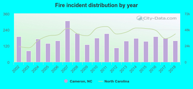 Based on the data from the years 2002 - 2018 the average number of fire incidents per year is 171. The highest number of fires - 308 took place in 2007, and the least - 83 in 2003. The data has a declining trend.
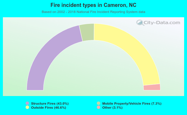 When looking into fire subcategories, the most reports belonged to: Outside Fires (46.6%), and Structure Fires (43.0%).
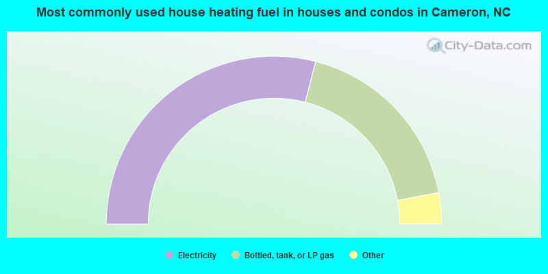
- 58.3%Electricity
- 36.2%Bottled, tank, or LP gas
- 3.1%Fuel oil, kerosene, etc.
- 2.4%Wood

- 84.6%Electricity
- 15.4%Bottled, tank, or LP gas
Cameron compared to North Carolina state average:
- Median house value below state average.
- Black race population percentage significantly above state average.
- Foreign-born population percentage significantly below state average.
- Renting percentage below state average.
- Length of stay since moving in significantly above state average.
- House age significantly above state average.

|
|
Total of 9 patent applications in 2008-2024.