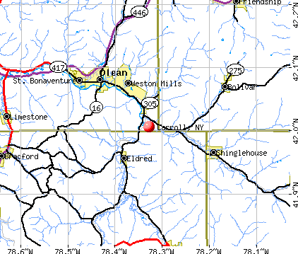
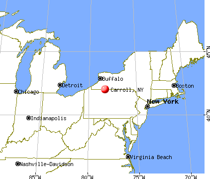
Carroll, New York
Submit your own pictures of this town and show them to the world
- OSM Map
- General Map
- Google Map
- MSN Map
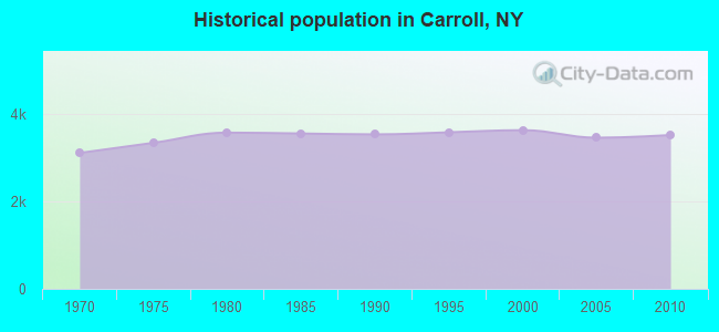
Population change since 2000: -3.1%
 |
| Males: 1,721 | |
| Females: 1,803 |
| Median resident age: | 45.3 years |
| New York median age: | 40.7 years |
Zip codes: 14738.
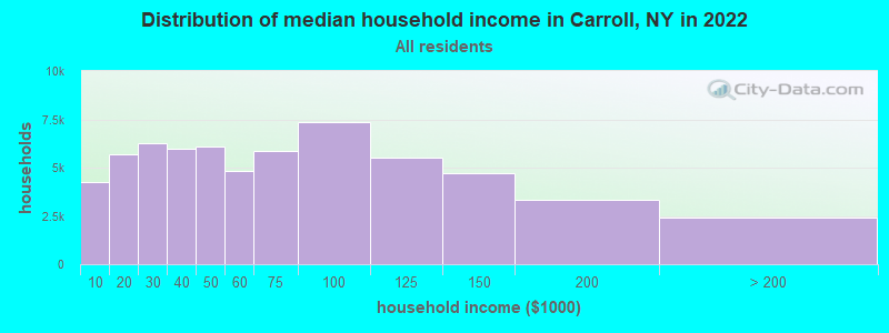
| Carroll: | $63,504 |
| NY: | $79,557 |
Estimated per capita income in 2022: $32,112 (it was $16,828 in 2000)
Carroll town income, earnings, and wages data
Estimated median house or condo value in 2022: $129,533 (it was $66,300 in 2000)
| Carroll: | $129,533 |
| NY: | $400,400 |
Mean prices in 2022: all housing units: $168,876; detached houses: $173,869; townhouses or other attached units: $92,544; in 2-unit structures: $200,826; in 3-to-4-unit structures: $86,545; in 5-or-more-unit structures: $466,469; mobile homes: $70,313
Detailed information about poverty and poor residents in Carroll, NY


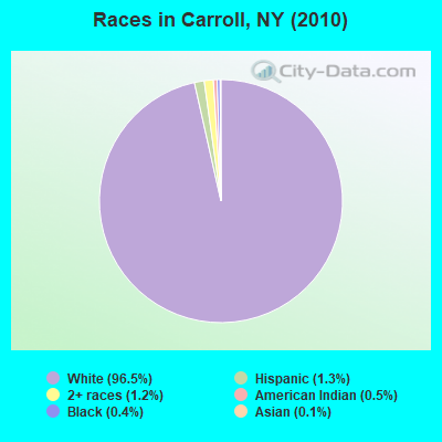
- 3,40296.5%White alone
- 461.3%Hispanic
- 411.2%Two or more races
- 160.5%American Indian alone
- 130.4%Black alone
- 50.1%Asian alone
- 10.03%Other race alone
Races in Carroll detailed stats: ancestries, foreign born residents, place of birth
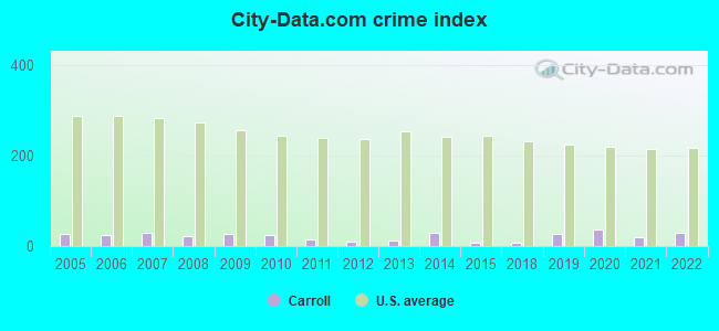
Type |
2009 |
2010 |
2011 |
2012 |
2013 |
2014 |
2015 |
2018 |
2019 |
2020 |
2021 |
2022 |
|---|---|---|---|---|---|---|---|---|---|---|---|---|
| Murders (per 100,000) | 0 (0.0) | 0 (0.0) | 0 (0.0) | 0 (0.0) | 0 (0.0) | 0 (0.0) | 0 (0.0) | 0 (0.0) | 0 (0.0) | 0 (0.0) | 0 (0.0) | 0 (0.0) |
| Rapes (per 100,000) | 0 (0.0) | 0 (0.0) | 0 (0.0) | 0 (0.0) | 0 (0.0) | 0 (0.0) | 0 (0.0) | 0 (0.0) | 0 (0.0) | 0 (0.0) | 0 (0.0) | 0 (0.0) |
| Robberies (per 100,000) | 0 (0.0) | 0 (0.0) | 0 (0.0) | 0 (0.0) | 0 (0.0) | 0 (0.0) | 0 (0.0) | 0 (0.0) | 0 (0.0) | 0 (0.0) | 0 (0.0) | 0 (0.0) |
| Assaults (per 100,000) | 2 (58.1) | 2 (56.8) | 1 (28.2) | 0 (0.0) | 0 (0.0) | 4 (115.6) | 0 (0.0) | 0 (0.0) | 0 (0.0) | 0 (0.0) | 0 (0.0) | 1 (29.4) |
| Burglaries (per 100,000) | 3 (87.2) | 5 (141.9) | 3 (84.7) | 3 (85.0) | 3 (86.2) | 0 (0.0) | 0 (0.0) | 1 (29.9) | 5 (150.2) | 5 (151.1) | 3 (91.2) | 7 (205.5) |
| Thefts (per 100,000) | 7 (203.4) | 3 (85.1) | 3 (84.7) | 4 (113.4) | 5 (143.6) | 4 (115.6) | 7 (204.1) | 5 (149.4) | 14 (420.5) | 18 (544.0) | 8 (243.1) | 7 (205.5) |
| Auto thefts (per 100,000) | 0 (0.0) | 0 (0.0) | 0 (0.0) | 0 (0.0) | 0 (0.0) | 0 (0.0) | 0 (0.0) | 0 (0.0) | 0 (0.0) | 2 (60.4) | 1 (30.4) | 0 (0.0) |
| Arson (per 100,000) | 0 (0.0) | 0 (0.0) | 0 (0.0) | 0 (0.0) | 0 (0.0) | 0 (0.0) | 0 (0.0) | 0 (0.0) | 0 (0.0) | 0 (0.0) | 0 (0.0) | 0 (0.0) |
| City-Data.com crime index | 25.9 | 24.7 | 15.0 | 10.5 | 11.8 | 27.7 | 8.2 | 8.1 | 27.3 | 37.2 | 18.5 | 28.5 |
The City-Data.com crime index weighs serious crimes and violent crimes more heavily. Higher means more crime, U.S. average is 246.1. It adjusts for the number of visitors and daily workers commuting into cities.
Crime rate in Carroll detailed stats: murders, rapes, robberies, assaults, burglaries, thefts, arson
 Recent articles from our blog. Our writers, many of them Ph.D. graduates or candidates, create easy-to-read articles on a wide variety of topics.


 | Trump found GUILTY against E. Jean Carroll for battery and defamation in Manhattan Court (86 replies) |
| Trump Fined $355 MILLION and barred from Real Estate New York (294 replies) |
| Upper Middle class african-american communities in ny (2052 replies) |
| Good Cup of Coffee (80 replies) |
| Mom and Pop Shops in NYC (31 replies) |
| Moving to Brooklyn! (79 replies) |
Latest news from Carroll, NY collected exclusively by city-data.com from local newspapers, TV, and radio stations
Ancestries: Swedish (25.9%), German (24.5%), English (19.1%), Irish (15.1%), Italian (8.9%), United States (4.8%).
Current Local Time: EST time zone
Elevation: 1438 feet
Land area: 33.4 square miles.
Population density: 106 people per square mile (very low).
16 residents are foreign born
| This town: | 0.4% |
| New York: | 20.4% |
| Carroll town: | 2.8% ($1,861) |
| New York: | 1.9% ($2,847) |
Nearest city with pop. 50,000+: Erie, PA  (49.0 miles , pop. 103,717).
Nearest city with pop. 200,000+: Buffalo, NY (61.1 miles , pop. 292,648).
Nearest city with pop. 1,000,000+: Philadelphia, PA (251.4 miles , pop. 1,517,550).
Nearest cities:
), ), ), ), ), ), )Latitude: 42.05 N, Longitude: 79.13 W
Area code commonly used in this area: 716

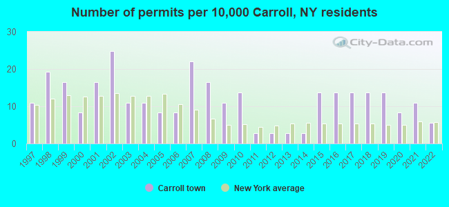
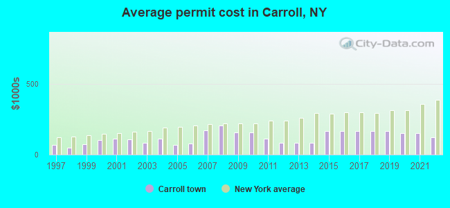
Single-family new house construction building permits:
- 2022: 2 buildings, average cost: $120,000
- 2021: 4 buildings, average cost: $150,700
- 2020: 3 buildings, average cost: $150,700
- 2019: 5 buildings, average cost: $168,000
- 2018: 5 buildings, average cost: $168,000
- 2017: 5 buildings, average cost: $168,000
- 2016: 5 buildings, average cost: $168,000
- 2015: 5 buildings, average cost: $168,000
- 2014: 1 building, cost: $85,000
- 2013: 1 building, cost: $85,000
- 2012: 1 building, cost: $85,000
- 2011: 1 building, cost: $110,000
- 2010: 5 buildings, average cost: $156,300
- 2009: 4 buildings, average cost: $156,300
- 2008: 6 buildings, average cost: $206,300
- 2007: 8 buildings, average cost: $171,900
- 2006: 3 buildings, average cost: $76,700
- 2005: 3 buildings, average cost: $67,000
- 2004: 4 buildings, average cost: $113,800
- 2003: 4 buildings, average cost: $84,500
- 2002: 9 buildings, average cost: $105,900
- 2001: 6 buildings, average cost: $111,800
- 2000: 3 buildings, average cost: $103,300
- 1999: 6 buildings, average cost: $70,800
- 1998: 7 buildings, average cost: $47,100
- 1997: 4 buildings, average cost: $68,800
| Here: | 4.8% |
| New York: | 4.4% |
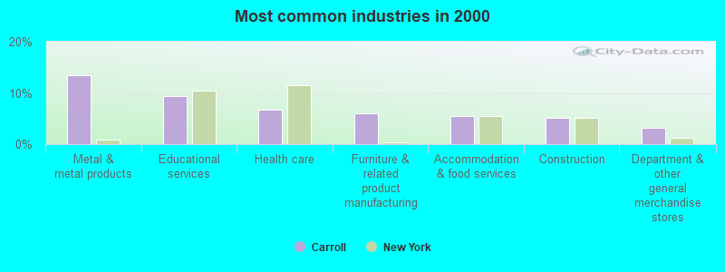
- Metal & metal products (13.4%)
- Educational services (9.4%)
- Health care (6.7%)
- Furniture & related product manufacturing (6.0%)
- Accommodation & food services (5.6%)
- Construction (5.1%)
- Department & other general merchandise stores (3.2%)
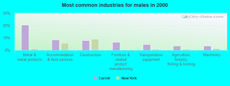
- Metal & metal products (20.4%)
- Accommodation & food services (8.4%)
- Construction (7.9%)
- Furniture & related product manufacturing (6.5%)
- Transportation equipment (4.7%)
- Agriculture, forestry, fishing & hunting (3.6%)
- Machinery (3.6%)
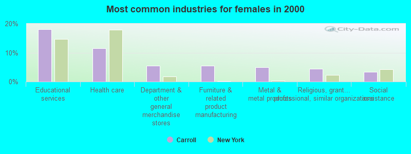
- Educational services (18.1%)
- Health care (11.5%)
- Department & other general merchandise stores (5.5%)
- Furniture & related product manufacturing (5.4%)
- Metal & metal products (4.9%)
- Religious, grantmaking, civic, professional, similar organizations (4.5%)
- Social assistance (3.4%)
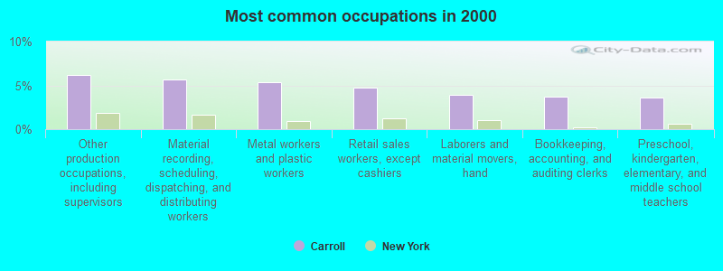
- Other production occupations, including supervisors (6.2%)
- Material recording, scheduling, dispatching, and distributing workers (5.6%)
- Metal workers and plastic workers (5.4%)
- Retail sales workers, except cashiers (4.8%)
- Laborers and material movers, hand (3.9%)
- Bookkeeping, accounting, and auditing clerks (3.7%)
- Preschool, kindergarten, elementary, and middle school teachers (3.6%)
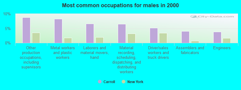
- Other production occupations, including supervisors (8.8%)
- Metal workers and plastic workers (8.2%)
- Laborers and material movers, hand (6.6%)
- Material recording, scheduling, dispatching, and distributing workers (6.5%)
- Driver/sales workers and truck drivers (5.1%)
- Assemblers and fabricators (4.0%)
- Engineers (3.8%)
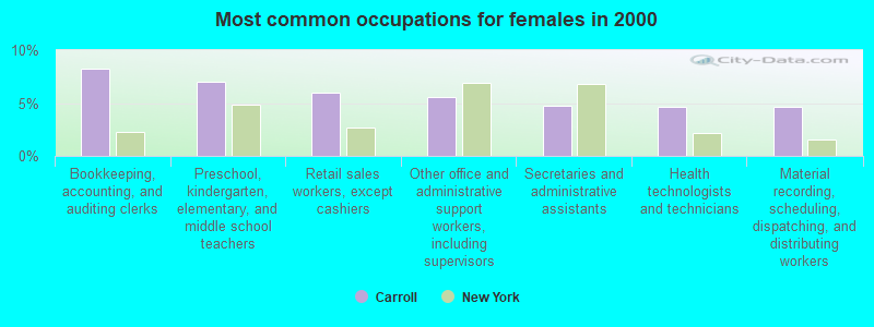
- Bookkeeping, accounting, and auditing clerks (8.3%)
- Preschool, kindergarten, elementary, and middle school teachers (7.0%)
- Retail sales workers, except cashiers (6.0%)
- Other office and administrative support workers, including supervisors (5.5%)
- Secretaries and administrative assistants (4.7%)
- Health technologists and technicians (4.6%)
- Material recording, scheduling, dispatching, and distributing workers (4.6%)
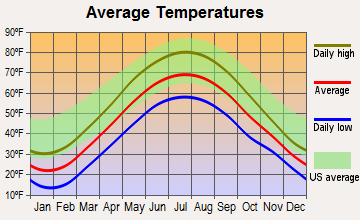
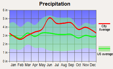
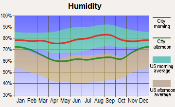
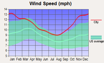
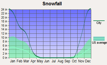
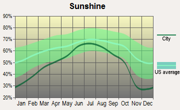
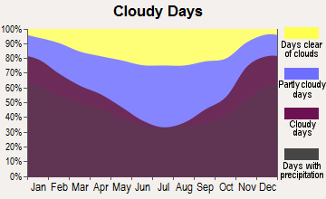
Average climate in Carroll, New York
Based on data reported by over 4,000 weather stations
(lower is better)
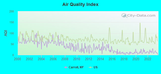
Air Quality Index (AQI) level in 2023 was 12.3. This is significantly better than average.
| City: | 12.3 |
| U.S.: | 72.6 |

Sulfur Dioxide (SO2) [ppb] level in 2023 was 1.53. This is about average. Closest monitor was 6.8 miles away from the city center.
| City: | 1.53 |
| U.S.: | 1.51 |
Tornado activity:
Carroll-area historical tornado activity is above New York state average. It is 41% smaller than the overall U.S. average.
On 5/31/1985, a category F4 (max. wind speeds 207-260 mph) tornado 15.6 miles away from the Carroll town center .
On 5/31/1985, a category F4 tornado 29.2 miles away from the town center killed 4 people and injured 40 people.
Earthquake activity:
Carroll-area historical earthquake activity is significantly above New York state average. It is 64% smaller than the overall U.S. average.On 9/25/1998 at 19:52:52, a magnitude 5.2 (4.8 MB, 4.3 MS, 5.2 LG, 4.5 MW, Depth: 3.1 mi, Class: Moderate, Intensity: VI - VII) earthquake occurred 75.9 miles away from Carroll center
On 1/31/1986 at 16:46:43, a magnitude 5.0 (5.0 MB) earthquake occurred 109.2 miles away from the city center
On 8/23/2011 at 17:51:04, a magnitude 5.8 (5.8 MW, Depth: 3.7 mi) earthquake occurred 292.9 miles away from Carroll center
On 10/7/1983 at 10:18:46, a magnitude 5.3 (5.1 MB, 5.3 LG, 5.1 ML) earthquake occurred 275.6 miles away from the city center
On 4/20/2002 at 10:50:47, a magnitude 5.3 (5.3 ML, Depth: 3.0 mi) earthquake occurred 322.2 miles away from Carroll center
On 1/16/1994 at 01:49:16, a magnitude 4.6 (4.6 MB, 4.6 LG, Depth: 3.1 mi, Class: Light, Intensity: IV - V) earthquake occurred 199.8 miles away from Carroll center
Magnitude types: regional Lg-wave magnitude (LG), body-wave magnitude (MB), local magnitude (ML), surface-wave magnitude (MS), moment magnitude (MW)
Natural disasters:
The number of natural disasters in Chautauqua County (21) is greater than the US average (15).Major Disasters (Presidential) Declared: 11
Emergencies Declared: 9
Causes of natural disasters: Floods: 9, Storms: 9, Snowstorms: 4, Hurricanes: 2, Winter Storms: 2, Blizzard: 1, Ice Storm: 1, Power Outage: 1, Snow: 1, Tropical Storm: 1, Wind: 1, Other: 2 (Note: some incidents may be assigned to more than one category).
Hospitals and medical centers near Carroll:
- CHAUTAUQUA COUNTY CHAPTER NYS ARC, INC (Hospital, about 6 miles away; JAMESTOWN, NY)
- WOMENS CHRISTIAN ASSOC. HOSP. (Dialysis Facility, about 7 miles away; JAMESTOWN, NY)
- WOMAN'S CHRISTIAN ASSOCIATION Acute Care Hospitals (about 7 miles away; JAMESTOWN, NY)
- LUTHERAN RETIREMENT HOME (Nursing Home, about 7 miles away; JAMESTOWN, NY)
- PRESBYTERIAN HOMES (Nursing Home, about 7 miles away; JAMESTOWN, NY)
- HERITAGE PARK HEALTH CARE CENTER (Nursing Home, about 7 miles away; JAMESTOWN, NY)
- JAMESTOWN GENERAL HOSPITAL (Hospital, about 7 miles away; JAMESTOWN, NY)
Colleges/universities with over 2000 students nearest to Carroll:
- Jamestown Community College (about 7 miles; Jamestown, NY; Full-time enrollment: 3,384)
- SUNY at Fredonia (about 31 miles; Fredonia, NY; FT enrollment: 5,523)
- St Bonaventure University (about 34 miles; Saint Bonaventure, NY; FT enrollment: 2,286)
- Pennsylvania State University-Penn State Erie-Behrend College (about 45 miles; Erie, PA; FT enrollment: 4,025)
- Mercyhurst University (about 48 miles; Erie, PA; FT enrollment: 2,888)
- Gannon University (about 50 miles; Erie, PA; FT enrollment: 3,760)
- Edinboro University of Pennsylvania (about 53 miles; Edinboro, PA; FT enrollment: 6,746)
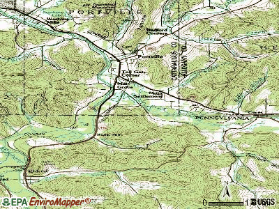
Points of interest:
Notable locations in Carroll: Kost Family Apiary (A), Windy Gale Farm (B), J - High Acres (C), Lake Erie Beagle Club (D), Myers Memorial Library (E), Carroll Town Hall (F), Frewsburg Fire Department (G), Frewsburg Rest Home for Adults (H). Display/hide their locations on the map
Churches in Carroll include: Wheeler Hill Church (A), Frewsburg Alliance Church (B), Trinity United Methodist Church (C), Ivory Baptist Church (D), Zion Lutheran Church (E), First Baptist Church (F), Frewsburg Methodist Church (G), Our Lady of Victory Roman Catholic Church (H), Oak Hill Church (I). Display/hide their locations on the map
Cemeteries: Maple Grove Cemetery (1), Fentonville Cemetery (2), Ivory Cemetery (3), Thayer Cemetery (4), Oak Hill Cemetery (5). Display/hide their locations on the map
Streams, rivers, and creeks: Frews Run (A), Wiltsie Run (B), Cass Run (C), Stillwater Creek (D). Display/hide their locations on the map
Birthplace of: Reuben Fenton - Politician.
| This town: | 2.4 people |
| New York: | 2.6 people |
| This town: | 67.8% |
| Whole state: | 63.5% |
| This town: | 5.8% |
| Whole state: | 6.8% |
Likely homosexual households (counted as self-reported same-sex unmarried-partner households)
- Lesbian couples: 0.1% of all households
- Gay men: 0.1% of all households
| This town: | 3.4% |
| Whole state: | 14.6% |
| This town: | 1.0% |
| Whole state: | 7.4% |
76 people in nursing homes in 2000
5 people in homes for the mentally retarded in 2000
For population 15 years and over in Carroll:
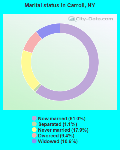
- Never married: 17.9%
- Now married: 61.0%
- Separated: 1.1%
- Widowed: 10.6%
- Divorced: 9.4%
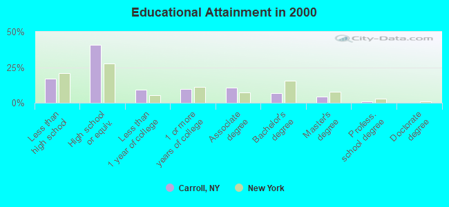
For population 25 years and over in Carroll:
- High school or higher: 83.0%
- Bachelor's degree or higher: 12.5%
- Graduate or professional degree: 5.7%
- Unemployed: 4.7%
- Mean travel time to work (commute): 18.8 minutes
| Here: | 9.4 |
| New York average: | 14.2 |
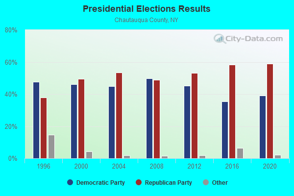
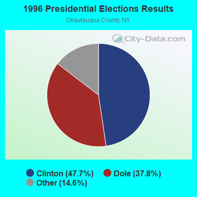
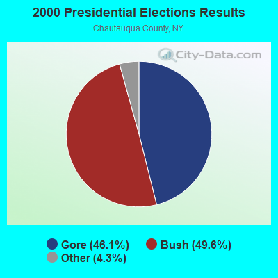
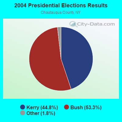
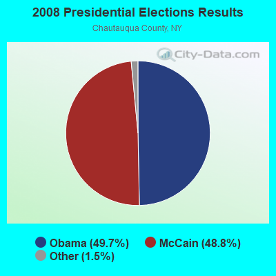
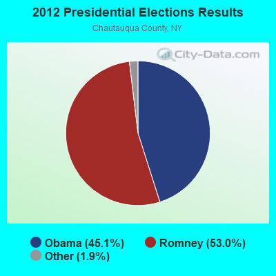
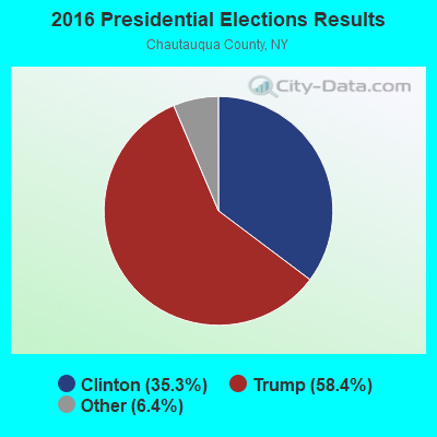
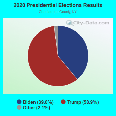
Graphs represent county-level data. Detailed 2008 Election Results
Religion statistics for Carroll, NY (based on Chautauqua County data)
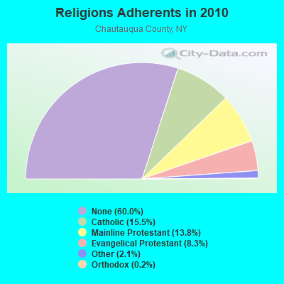
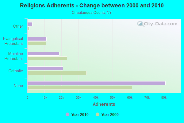
| Religion | Adherents | Congregations |
|---|---|---|
| Catholic | 20,912 | 13 |
| Mainline Protestant | 18,659 | 86 |
| Evangelical Protestant | 11,175 | 105 |
| Other | 2,884 | 19 |
| Orthodox | 230 | 2 |
| Black Protestant | 120 | 1 |
| None | 80,925 | - |
Food Environment Statistics:
| This county: | 2.76 / 10,000 pop. |
| New York: | 4.13 / 10,000 pop. |
| This county: | 0.07 / 10,000 pop. |
| State: | 0.06 / 10,000 pop. |
| This county: | 1.12 / 10,000 pop. |
| New York: | 0.92 / 10,000 pop. |
| Chautauqua County: | 3.06 / 10,000 pop. |
| State: | 1.68 / 10,000 pop. |
| Chautauqua County: | 11.05 / 10,000 pop. |
| New York: | 8.82 / 10,000 pop. |
| Here: | 8.1% |
| New York: | 8.2% |
| This county: | 29.3% |
| New York: | 23.8% |
| Chautauqua County: | 12.4% |
| New York: | 15.6% |
Strongest AM radio stations in Carroll:
- WNAE (1310 AM; 5 kW; WARREN, PA; Owner: KINZUA BROADCASTING COMPANY)
- WKSN (1340 AM; 1 kW; JAMESTOWN, NY; Owner: VOX ALLEGANY, L.L.C.)
- WJTN (1240 AM; 1 kW; JAMESTOWN, NY; Owner: MEDIA ONE GROUP, LLC)
- WWKB (1520 AM; 50 kW; BUFFALO, NY; Owner: ENTERCOM BUFFALO LICENSE, LLC)
- WGGO (1590 AM; 5 kW; SALAMANCA, NY; Owner: CATT COMMUNICATIONS, INC.)
- WHAM (1180 AM; 50 kW; ROCHESTER, NY; Owner: CITICASTERS LICENSES, L.P.)
- KDKA (1020 AM; 50 kW; PITTSBURGH, PA; Owner: INFINITY BROADCASTING OPERATIONS, INC.)
- WGR (550 AM; 5 kW; BUFFALO, NY; Owner: ENTERCOM BUFFALO LICENSE, LLC)
- WKNR (850 AM; 50 kW; CLEVELAND, OH; Owner: CARON BROADCASTING, INC.)
- WTAM (1100 AM; 50 kW; CLEVELAND, OH; Owner: JACOR BROADCASTING CORPORATION)
- WHK (1220 AM; 50 kW; CLEVELAND, OH; Owner: CARON BROADCASTING, INC.)
- WNED (970 AM; 5 kW; BUFFALO, NY)
- WRIE (1260 AM; 5 kW; ERIE, PA; Owner: REGENT LICENSEE OF ERIE, INC.)
Strongest FM radio stations in Carroll:
- WNJA (89.7 FM; JAMESTOWN, NY; Owner: WESTERN NEW YORK PUBLIC B/CING ASSOC)
- WCOT (90.9 FM; JAMESTOWN, NY; Owner: FAMILY LIFE MINISTRIES, INC.)
- WQFX-FM (103.1 FM; RUSSELL, PA; Owner: SOUTHBRIDGE RADIO CORPORATION)
- WKZA (106.9 FM; LAKEWOOD, NY; Owner: CROSS COUNTRY COMMUNICATIONS, LLC)
- WWSE (93.3 FM; JAMESTOWN, NY; Owner: MEDIA ONE GROUP, LLC)
- WMHU (101.9 FM; JAMESTOWN, NY; Owner: VOX ALLEGANY, L.L.C.)
- WUBJ (88.1 FM; JAMESTOWN, NY; Owner: STATE UNIVERSITY OF NEW YORK)
- W205BA (88.9 FM; JAMESTOWN, NY; Owner: BIBLE BROADCASTING NETWORK, INC.)
- WRRN (92.3 FM; WARREN, PA; Owner: KINZUA BROADCASTING COMPANY, INC.)
- WKNB (104.3 FM; CLARENDON, PA; Owner: KINZUA BROADCASTING CO., INC)
- WBKX (96.5 FM; FREDONIA, NY; Owner: CHADWICK BAY BROADCASTING CORPORATION)
- WBRR (100.1 FM; BRADFORD, PA; Owner: RADIO STATION WESB, INC.)
- WQRT (98.3 FM; SALAMANCA, NY; Owner: CATT COMMUNICATIONS, INC.)
- WTSS (102.5 FM; BUFFALO, NY; Owner: ENTERCOM BUFFALO LICENSE, LLC)
- WPSB (90.1 FM; KANE, PA; Owner: THE PENNSYLVANIA STATE UNIVERSITY)
- WQRM (106.3 FM; SMETHPORT, PA; Owner: FARM & HOME BROADCASTING COMPANY)
- WPIG (95.7 FM; OLEAN, NY; Owner: ARROW COMMUNICATIONS OF N.Y., INC.)
- WRKT (100.9 FM; NORTH EAST, PA; Owner: NM LICENSING, LLC)
- WOLN (91.3 FM; OLEAN, NY; Owner: STATE UNIVERSITY OF NEW YORK)
- WOGM-LP (105.9 FM; JAMESTOWN, NY; Owner: LIGHTHOUSE BAPTIST CHURCH)
TV broadcast stations around Carroll:
- W46BA (Channel 46; JAMESTOWN, NY; Owner: WESTERN NEW YORK PUBLIC B/CING.ASSN.)
- WNYB (Channel 26; JAMESTOWN, NY; Owner: FAITH BROADCASTING NETWORK, INC.)
- WNGS (Channel 67; SPRINGVILLE, NY; Owner: CAROLINE K. POWLEY D/B/A UNICORN/SPRINGVILLE)
- W10BH (Channel 10; JAMESTOWN, NY; Owner: TRINITY BROADCASTING NETWORK)
- W56AD (Channel 56; KENNEDY, NY; Owner: WESTERN NEW YORK PUBLIC B/CING.ASSN.)
- National Bridge Inventory (NBI) Statistics
- 17Number of bridges
- 102ft / 30.6mTotal length
- $21,023,000Total costs
- 16,615Total average daily traffic
- 1,309Total average daily truck traffic
- 19,342Total future (year 2038) average daily traffic
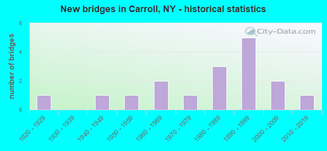
- New bridges - historical statistics
- 11920-1929
- 11940-1949
- 11950-1959
- 21960-1969
- 11970-1979
- 31980-1989
- 51990-1999
- 22000-2009
- 12010-2019
FCC Registered Antenna Towers:
6- Robert Tiller, Robin Hill Rd 18 Km At 126 Degrees From Jamestown (Lat: 42.006389 Lon: -79.064444), Type: 36.0, Overall height: 36 m, Registrant: Family Life Ministries Radio Inc Dba , Famlife@aol.Com, , 506 Bath, Phone: (607) 776-4151
- Dennen J Bunger, 62 Oak Hill Rd. (Lat: 42.046778 Lon: -79.090111), Type: 73.2, Structure height: 36013 m, Overall height: 73.2 m, Registrant: C&s Companies, Dbunger@cscos.Com, , Syrac-use, Phone: (315) 703-4155
- Dennen J Bunger, 62 Oak Hill Rd. (Lat: 42.046778 Lon: -79.090111), Type: 73.2, Structure height: 36013 m, Overall height: 73.2 m, Registrant: C&s Companies, Dbunger@cscos.Com, , Syrac-use, Phone: (315) 703-4155
- Dennen J Bunger, 62 Oak Hill Rd. (Lat: 42.046778 Lon: -79.090111), Type: 73.2, Structure height: 36013 m, Overall height: 73.2 m, Registrant: C&s Companies, Dbunger@cscos.Com, , Syrac-use, Phone: (315) 703-4155
- Dennen J Bunger, 62 Oak Hill Rd. (Lat: 42.046778 Lon: -79.090111), Type: 73.2, Structure height: 36013 m, Overall height: 73.2 m, Registrant: C&s Companies, Dbunger@cscos.Com, , Syrac-use, Phone: (315) 703-4155
- Robin Hill Rd 18 Km At 126 Degrees From Jamestown (Lat: 42.006389 Lon: -79.064444), Type: 36.0, Overall height: 36 m, Registrant: Family Life Ministries Radio Inc Dba , Famlife@aol.Com, , 506 Bath, Phone: (607) 776-4151
FCC Registered Broadcast Land Mobile Towers:
3- Robin Hill Road (Lat: 42.006389 Lon: -79.064444), Type: Tower, Structure height: 36 m, Call Sign: WPVV415,
Assigned Frequencies: 160.350 MHz, Grant Date: 09/12/2002, Expiration Date: 09/12/2012, Cancellation Date: 11/18/2011, Certifier: Gary E Landrio, Registrant: Western New York & Pennsylvania Railroad, LLC, 5769 Sweeteners Blvd, Lakeville, NY 14480, Phone: (585) 346-2090, Fax: (585) 346-6454, Email:
- Robin Hill Rd 18 Km At 126 Degrees From Jamestown (Lat: 42.006389 Lon: -79.064444), Type: Tower, Structure height: 36 m, Call Sign: WQAU769,
Assigned Frequencies: 159.510 MHz, 151.370 MHz, 151.370 MHz, Grant Date: 09/12/2014, Expiration Date: 08/10/2024, Certifier: Robert Tiller, Registrant: National Grid Usa Service Company Inc., 300 Erie Boulevard West, Syracuse, DC 13202, Phone: (781) 907-3409, Fax: (781) 907-5715, Email:
- OAK HILL, 62 Oak Hill Rd. (Lat: 42.046778 Lon: -79.090111), Type: Ltower, Structure height: 73.2 m, Call Sign: WQUZ436,
Assigned Frequencies: 154.785 MHz, 159.172 MHz, 159.105 MHz, 156.240 MHz, Grant Date: 11/25/2014, Expiration Date: 11/25/2024, Certifier: Matthew Trusso, Registrant: V-Comm, L.L.C., 2540 Us Highway 130, Suite 101, Cranbury, NJ 08512-3500, Phone: (609) 655-1200, Fax: (609) 409-1927, Email:
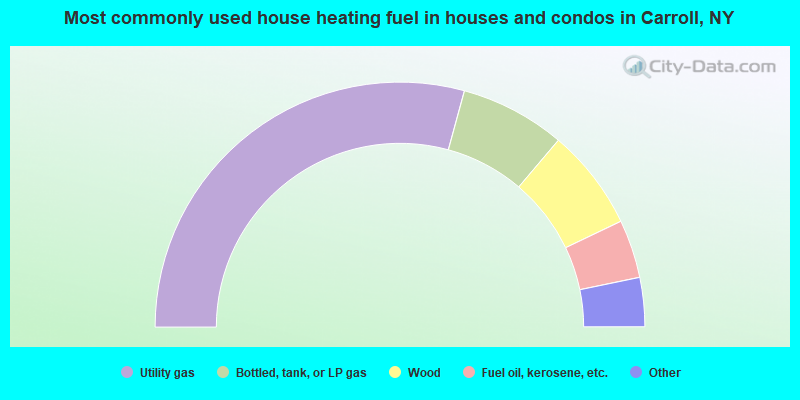
- 58.5%Utility gas
- 13.9%Bottled, tank, or LP gas
- 13.4%Wood
- 7.7%Fuel oil, kerosene, etc.
- 3.7%Other fuel
- 2.7%Electricity
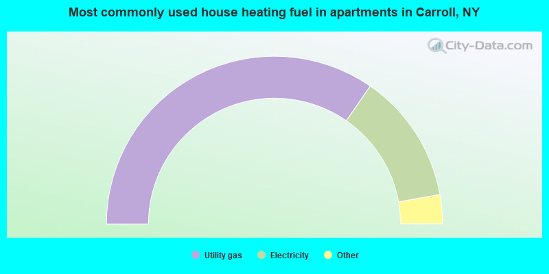
- 69.3%Utility gas
- 25.1%Electricity
- 3.7%Wood
- 1.9%Bottled, tank, or LP gas
Carroll compared to New York state average:
- Median house value significantly below state average.
- Unemployed percentage significantly below state average.
- Black race population percentage significantly below state average.
- Hispanic race population percentage significantly below state average.
- Median age above state average.
- Foreign-born population percentage significantly below state average.
- Renting percentage below state average.
- Length of stay since moving in significantly above state average.
- Number of rooms per house significantly below state average.
- House age significantly below state average.
- Percentage of population with a bachelor's degree or higher significantly below state average.