Cloverdale, Alabama
Submit your own pictures of this place and show them to the world
- OSM Map
- General Map
- Google Map
- MSN Map

| Males: 3,100 | |
| Females: 3,109 |
| Median resident age: | 35.9 years |
| Alabama median age: | 35.8 years |
Zip code: 35633
| Cloverdale: | $55,958 |
| AL: | $59,674 |
Estimated per capita income in 2022: $25,786 (it was $14,568 in 2000)
Cloverdale CCD income, earnings, and wages data
Estimated median house or condo value in 2022: $151,757 (it was $65,200 in 2000)
| Cloverdale: | $151,757 |
| AL: | $200,900 |
Detailed information about poverty and poor residents in Cloverdale, AL


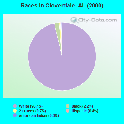
- 5,95196.4%White alone
- 1352.2%Black alone
- 430.7%Two or more races
- 270.4%Hispanic
- 160.3%American Indian alone
 Recent articles from our blog. Our writers, many of them Ph.D. graduates or candidates, create easy-to-read articles on a wide variety of topics.
Current Local Time: CST time zone
Land area: 83.9 square miles.
Population density: 74 people per square mile (very low).

| Cloverdale CCD: | 0.3% ($199) |
| Alabama: | 0.4% ($289) |
Nearest city with pop. 50,000+: Decatur, AL  (52.2 miles , pop. 53,929).
Nearest city with pop. 200,000+: Metropolitan Government, TN (101.7 miles , pop. 569,891).
Nearest city with pop. 1,000,000+: Chicago, IL (477.1 miles , pop. 2,896,016).
Nearest cities:
), ), ), ), ), )Latitude: 34.94 N, Longitude: 87.79 W
Area code commonly used in this area: 256

| Here: | 2.7% |
| Alabama: | 2.6% |
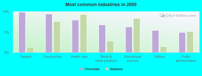
- Apparel (9.9%)
- Construction (9.4%)
- Health care (8.0%)
- Metal & metal products (6.8%)
- Educational services (6.3%)
- Utilities (5.4%)
- Public administration (4.9%)
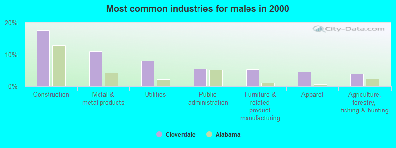
- Construction (17.6%)
- Metal & metal products (11.0%)
- Utilities (8.1%)
- Public administration (5.5%)
- Furniture & related product manufacturing (5.4%)
- Apparel (4.6%)
- Agriculture, forestry, fishing & hunting (4.1%)
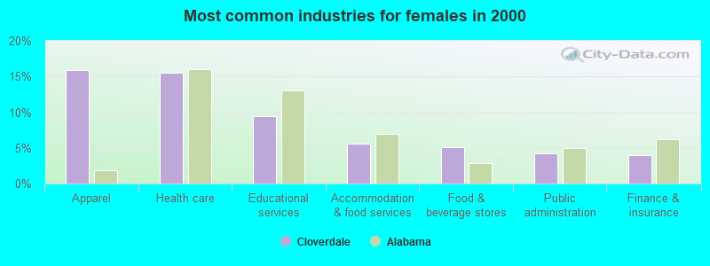
- Apparel (15.9%)
- Health care (15.5%)
- Educational services (9.5%)
- Accommodation & food services (5.6%)
- Food & beverage stores (5.1%)
- Public administration (4.2%)
- Finance & insurance (4.0%)
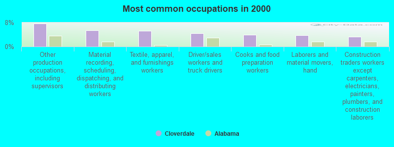
- Other production occupations, including supervisors (7.6%)
- Material recording, scheduling, dispatching, and distributing workers (5.5%)
- Textile, apparel, and furnishings workers (5.3%)
- Driver/sales workers and truck drivers (4.3%)
- Cooks and food preparation workers (3.9%)
- Laborers and material movers, hand (3.7%)
- Construction traders workers except carpenters, electricians, painters, plumbers, and construction laborers (3.3%)
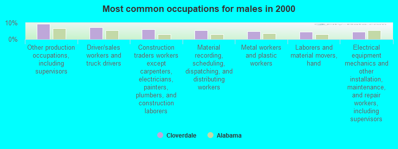
- Other production occupations, including supervisors (9.4%)
- Driver/sales workers and truck drivers (7.4%)
- Construction traders workers except carpenters, electricians, painters, plumbers, and construction laborers (6.1%)
- Material recording, scheduling, dispatching, and distributing workers (5.4%)
- Metal workers and plastic workers (4.8%)
- Laborers and material movers, hand (4.6%)
- Electrical equipment mechanics and other installation, maintenance, and repair workers, including supervisors (4.6%)

- Textile, apparel, and furnishings workers (8.4%)
- Cooks and food preparation workers (7.6%)
- Cashiers (6.2%)
- Secretaries and administrative assistants (6.0%)
- Material recording, scheduling, dispatching, and distributing workers (5.6%)
- Other production occupations, including supervisors (5.6%)
- Health technologists and technicians (4.3%)
Average climate in Cloverdale, Alabama
Based on data reported by over 4,000 weather stations


(lower is better)
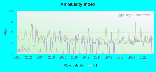
Air Quality Index (AQI) level in 2022 was 55.1. This is better than average.
| City: | 55.1 |
| U.S.: | 72.6 |
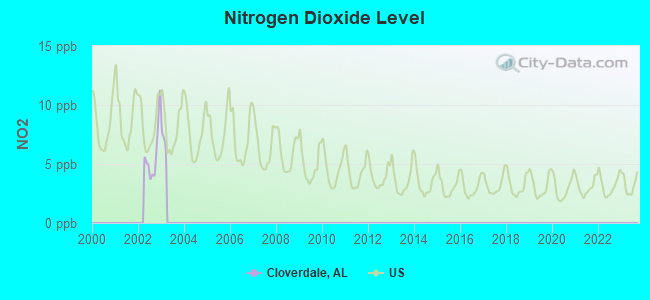
Nitrogen Dioxide (NO2) [ppb] level in 2002 was 5.86. This is about average. Closest monitor was 15.2 miles away from the city center.
| City: | 5.86 |
| U.S.: | 5.11 |
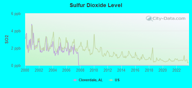
Sulfur Dioxide (SO2) [ppb] level in 2007 was 1.62. This is about average. Closest monitor was 10.9 miles away from the city center.
| City: | 1.62 |
| U.S.: | 1.51 |
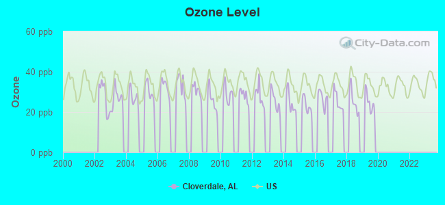
Ozone [ppb] level in 2019 was 24.8. This is better than average. Closest monitor was 15.2 miles away from the city center.
| City: | 24.8 |
| U.S.: | 33.3 |
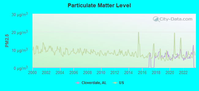
Particulate Matter (PM2.5) [µg/m3] level in 2022 was 5.72. This is significantly better than average. Closest monitor was 21.6 miles away from the city center.
| City: | 5.72 |
| U.S.: | 8.11 |
Tornado activity:
Cloverdale-area historical tornado activity is near Alabama state average. It is 107% greater than the overall U.S. average.
On 4/16/1998, a category F5 (max. wind speeds 261-318 mph) tornado 23.2 miles away from the Cloverdale place center killed 3 people and injured 36 people and caused $13 million in damages.
On 5/18/1995, a category F4 (max. wind speeds 207-260 mph) tornado 17.9 miles away from the place center killed 3 people and injured 32 people and caused between $500,000 and $5,000,000 in damages.
Earthquake activity:
Cloverdale-area historical earthquake activity is significantly above Alabama state average. It is 232% greater than the overall U.S. average.On 4/29/2003 at 08:59:39, a magnitude 4.9 (4.4 MB, 4.6 MW, 4.9 LG, Class: Light, Intensity: IV - V) earthquake occurred 126.6 miles away from the city center
On 3/25/1976 at 00:41:20, a magnitude 5.0 (4.9 MB, 5.0 LG, Class: Moderate, Intensity: VI - VII) earthquake occurred 151.1 miles away from the city center
On 1/18/1999 at 07:00:53, a magnitude 4.8 (4.8 MB, 4.0 LG, Depth: 0.6 mi) earthquake occurred 110.7 miles away from the city center
On 5/4/1991 at 01:18:54, a magnitude 5.0 (4.4 MB, 4.6 LG, 5.0 LG, Depth: 3.1 mi) earthquake occurred 160.0 miles away from Cloverdale center
On 4/18/2008 at 09:36:59, a magnitude 5.4 (5.1 MB, 4.8 MS, 5.4 MW, 5.2 MW) earthquake occurred 242.7 miles away from Cloverdale center
On 9/26/1990 at 13:18:51, a magnitude 5.0 (4.7 MB, 4.8 LG, 5.0 LG, Depth: 7.7 mi) earthquake occurred 182.2 miles away from the city center
Magnitude types: regional Lg-wave magnitude (LG), body-wave magnitude (MB), surface-wave magnitude (MS), moment magnitude (MW)
Natural disasters:
The number of natural disasters in Lauderdale County (16) is near the US average (15).Major Disasters (Presidential) Declared: 10
Emergencies Declared: 5
Causes of natural disasters: Floods: 7, Storms: 7, Tornadoes: 5, Hurricanes: 4, Winds: 3, Freezes: 2, Winter Storms: 2, Drought: 1, Ice Storm: 1, Snowfall: 1, Other: 1 (Note: some incidents may be assigned to more than one category).
Hospitals and medical centers near Cloverdale:
- HOSPICE OF TENNESSEE VALLEY INC (Hospital, about 9 miles away; FLORENCE, AL)
- HOSPICE OF THE SHOALS, INC (Hospital, about 10 miles away; FLORENCE, AL)
- FLORENCE NURSING AND REHABILITATION CENTER (Nursing Home, about 11 miles away; FLORENCE, AL)
- FLORENCE HOSPITAL (Hospital, about 11 miles away; FLORENCE, AL)
- MITCHELL-HOLLINGSWORTH NURSING AND REHABILITATION (Nursing Home, about 12 miles away; FLORENCE, AL)
- DAVITA RENAISSANCE (Dialysis Facility, about 12 miles away; FLORENCE, AL)
- GLENWOOD HEALTHCARE, INC. (Nursing Home, about 12 miles away; FLORENCE, AL)
Colleges/universities with over 2000 students nearest to Cloverdale:
- University of North Alabama (about 12 miles; Florence, AL; Full-time enrollment: 5,886)
- Northwest-Shoals Community College (about 16 miles; Muscle Shoals, AL; FT enrollment: 2,702)
- Athens State University (about 48 miles; Athens, AL; FT enrollment: 2,771)
- Northeast Mississippi Community College (about 48 miles; Booneville, MS; FT enrollment: 3,024)
- John C Calhoun State Community College (about 52 miles; Tanner, AL; FT enrollment: 7,911)
- Itawamba Community College (about 59 miles; Fulton, MS; FT enrollment: 5,489)
- Columbia State Community College (about 61 miles; Columbia, TN; FT enrollment: 3,383)
Points of interest:
Notable locations in Cloverdale: Central Area Volunteer Fire Department (A), Cloverdale Volunteer Fire Department Station 1 (B), Cloverdale Volunteer Fire Department Station 2 (C). Display/hide their locations on the map
Churches in Cloverdale include: Pisgah First Methodist Church (A), Pisgah African Methodist Episcopal Church (B), Pine Hill Church of Christ (C), Parker Chapel Missionary Baptist Church (D), New Home Baptist Church (E), Murphy Chapel (F), Little Zion Missionary Baptist Church (G), Lindseys Chapel Freewill Baptist Church of God (H), Liberty Baptist Church (I). Display/hide their locations on the map
Cemeteries: Simmons Cemetery (1), Jackson Cemetery (2), Dowdy Cemetery (3), Paulk Cemetery (4), Austin Cemetery (5), Francis-King-Lucas Cemetery (6), George Cemetery (7). Display/hide their locations on the map
Lake: Abramson Lake (A). Display/hide its location on the map
Streams, rivers, and creeks: Threet Creek (A), Latham Branch (B), Little Cypress Creek (C), Middle Cypress Creek (D), Parsonage Branch (E), Oakley Springs Branch (F), North Fork Cypress Creek (G), Posey Branch (H), Lyles Branch (I). Display/hide their locations on the map
| This place: | 2.6 people |
| Alabama: | 2.5 people |
| This place: | 75.0% |
| Whole state: | 67.8% |
| This place: | 4.0% |
| Whole state: | 4.7% |
Likely homosexual households (counted as self-reported same-sex unmarried-partner households)
- Lesbian couples: 0.2% of all households
- Gay men: 0.2% of all households
| This place: | 13.9% |
| Whole state: | 16.1% |
| This place: | 3.8% |
| Whole state: | 7.3% |
3 people in workers' group living quarters and job corps centers in 2010
For population 15 years and over in Cloverdale:
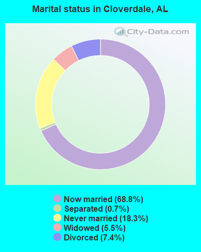
- Never married: 18.3%
- Now married: 68.8%
- Separated: 0.7%
- Widowed: 5.5%
- Divorced: 7.4%
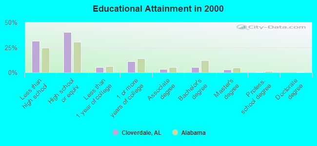
For population 25 years and over in Cloverdale:
- High school or higher: 68.2%
- Bachelor's degree or higher: 8.5%
- Graduate or professional degree: 3.1%
- Unemployed: 4.3%
- Mean travel time to work (commute): 26.8 minutes
| Here: | 10.7 |
| Alabama average: | 13.2 |
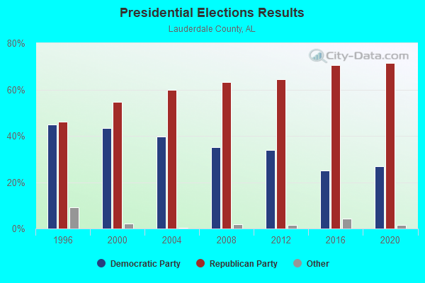
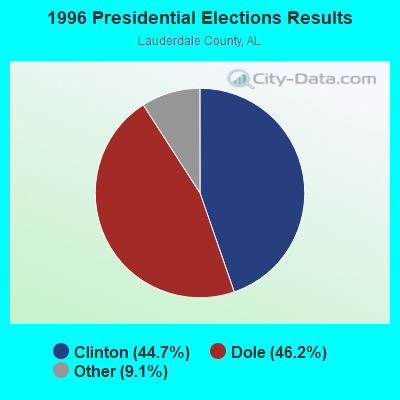
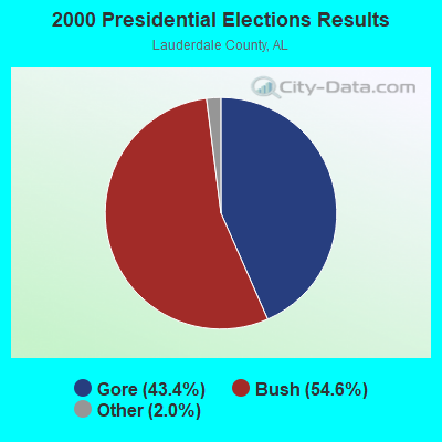
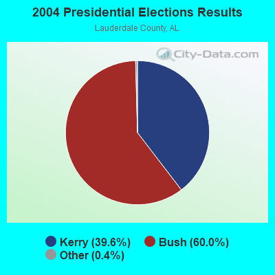
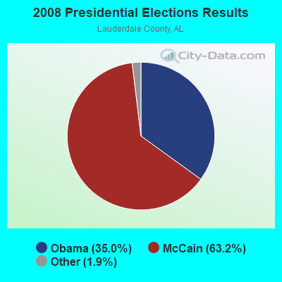
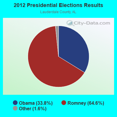
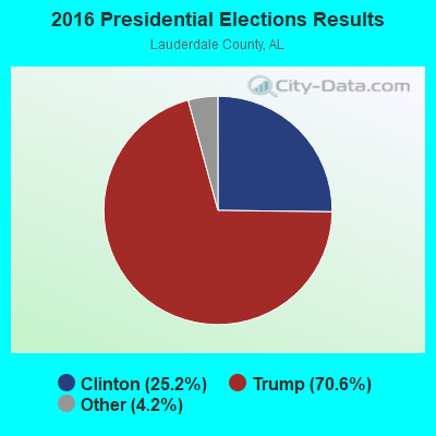
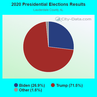
Graphs represent county-level data. Detailed 2008 Election Results
Religion statistics for Cloverdale, AL (based on Lauderdale County data)
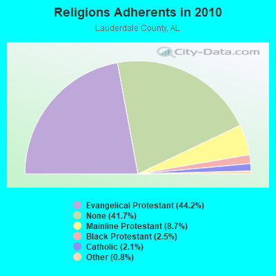
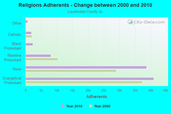
| Religion | Adherents | Congregations |
|---|---|---|
| Evangelical Protestant | 40,963 | 144 |
| Mainline Protestant | 8,079 | 38 |
| Black Protestant | 2,346 | 19 |
| Catholic | 1,948 | 2 |
| Other | 727 | 3 |
| None | 38,646 | - |
Food Environment Statistics:
| This county: | 1.58 / 10,000 pop. |
| State: | 1.89 / 10,000 pop. |
| This county: | 0.23 / 10,000 pop. |
| Alabama: | 0.20 / 10,000 pop. |
| This county: | 1.24 / 10,000 pop. |
| Alabama: | 0.65 / 10,000 pop. |
| Lauderdale County: | 5.65 / 10,000 pop. |
| Alabama: | 6.32 / 10,000 pop. |
| This county: | 7.01 / 10,000 pop. |
| State: | 5.75 / 10,000 pop. |
| Here: | 11.9% |
| State: | 11.8% |
| This county: | 30.1% |
| Alabama: | 31.7% |
| This county: | 15.1% |
| Alabama: | 13.5% |
Strongest AM radio stations in Cloverdale:
- WVNA (1590 AM; 5 kW; TUSCUMBIA, AL; Owner: CLEAR CHANNEL BROADCASTING LICENSES, INC.)
- WZNN (620 AM; 5 kW; LEXINGTON, AL; Owner: MANUEL HUERTA)
- WSM (650 AM; 50 kW; NASHVILLE, TN; Owner: GAYLORD ENTERTAINMENT COMPANY)
- WLOR (1550 AM; 50 kW; HUNTSVILLE, AL; Owner: BCA RADIO, LLC)
- WBCF (1240 AM; 1 kW; FLORENCE, AL; Owner: BENNY CARLE BROADCASTING, INC.)
- WCPC (940 AM; 50 kW; HOUSTON, MS; Owner: WCPC BROADCASTING CO., INC.)
- WJOX (690 AM; 50 kW; BIRMINGHAM, AL; Owner: CITADEL BROADCASTING COMPANY)
- WVNN (770 AM; 10 kW; ATHENS, AL; Owner: ATHENS BROADCASTING COMPANY, INC.)
- WCRV (640 AM; 50 kW; COLLIERVILLE, TN; Owner: BOTT BROADCASTING COMPANY/TENNESSEE)
- WSBM (1340 AM; 1 kW; FLORENCE, AL; Owner: BIG RIVER B/CING. CORP.)
- WDJC (850 AM; 50 kW; BIRMINGHAM, AL; Owner: KIMTRON, INC.)
- WBTG (1290 AM; 1 kW; SHEFFIELD, AL)
- WKDA (1200 AM; 50 kW; NASHVILLE, TN; Owner: RADIO NASHVILLE, INC.)
Strongest FM radio stations in Cloverdale:
- WLAY-FM (100.3 FM; TUSCUMBIA, AL; Owner: CLEAR CHANNEL BROADCASTING LICENSES, INC.)
- WQLT-FM (107.3 FM; FLORENCE, AL; Owner: BIG RIVER BROADCASTING CORPORATION)
- WMSR-FM (94.9 FM; COLLINWOOD, TN; Owner: OHIO BROADCAST ASSOCIATES)
- WFIX (91.3 FM; FLORENCE, AL; Owner: TRI-STATE INSPIRATIONAL B/C CORP.)
- WXFL (96.1 FM; FLORENCE, AL; Owner: BIG RIVER BROADCASTING CORP.)
- W254AA (98.7 FM; COLBERT HEIGHTS, AL; Owner: WILLIAM P. ROGERS)
- WVNA-FM (105.5 FM; MUSCLE SHOALS, AL; Owner: CLEAR CHANNEL BROADCASTING LICENSES, INC.)
- WBTG-FM (106.3 FM; SHEFFIELD, AL; Owner: SLATTON & ASSOCS. BROADCASTERS, INC.)
- WJOR-FM (101.5 FM; ST. JOSEPH, TN; Owner: CLEAR CHANNEL BROADCASTING LICENSES, INC.)
- WDNX (89.1 FM; OLIVE HILL, TN; Owner: RURAL LIFE FOUNDATION, INC)
- WAKD (89.9 FM; SHEFFIELD, AL; Owner: AMERICAN FAMILY ASSOCIATION)
- WMXV (103.5 FM; RUSSELLVILLE, AL; Owner: CLEAR CHANNEL BROADCASTING LICENSES, INC.)
- WYTK (93.9 FM; ROGERSVILLE, AL; Owner: SHOALS BROADCASTING CORPORATION)
- W202BY (88.3 FM; KILLEN, AL; Owner: WAY-FM MEDIA GROUP, INC.)
- WOWL (91.9 FM; BURNSVILLE, MS; Owner: SOUTHERN COMMUNITY SERVICES, INC)
- WQPR (88.7 FM; MUSCLE SHOALS, AL; Owner: THE BD OF TRUSTEES UNIV. OF ALABAMA)
- W258AE (99.5 FM; FLORENCE, AL; Owner: WAY-FM MEDIA GROUP, INC.)
- W274AA (102.7 FM; MUSCLE SHOALS, AL; Owner: WILLIAM P. ROGERS)
- WFXO (104.9 FM; IUKA, MS; Owner: BILLY R. MCLAIN)
- W225AB (92.9 FM; FLORENCE, AL; Owner: WILLIAM P. ROGERS)
TV broadcast stations around Cloverdale:
- WHDF (Channel 15; FLORENCE, AL; Owner: VALLEY TELEVISION, LLC)
- WBCF-LP (Channel 3; FLORENCE, AL; Owner: BENNY CARLE BROADCASTING, INC.)
- WXFL-LP (Channel 5; FLORENCE, ETC., AL; Owner: BENNY CARLE BROADCASTING, INC.)
- W57BV (Channel 57; FLORENCE, AL; Owner: TRINITY BROADCASTING NETWORK)
- WYLE (Channel 26; FLORENCE, AL; Owner: ETC COMMUNICATIONS INC.)
- WFIQ (Channel 36; FLORENCE, AL; Owner: ALABAMA EDUCATIONAL TELEVISION COMMISSION)
FCC Registered Antenna Towers:
15 (See the full list of FCC Registered Antenna Towers in Cloverdale)FCC Registered Amateur Radio Licenses:
1- Call Sign: KB4PON, Grant Date: 09/03/1997, Expiration Date: 09/03/2007, Cancellation Date: 09/04/2009, Registrant: Bryan K Price, Cloverdale, AL 35617-0032

- 42.2%Electricity
- 28.1%Bottled, tank, or LP gas
- 23.5%Utility gas
- 3.4%Wood
- 2.0%Fuel oil, kerosene, etc.
- 0.8%No fuel used
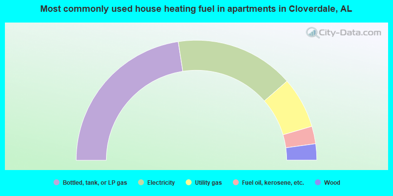
- 45.2%Bottled, tank, or LP gas
- 32.0%Electricity
- 13.8%Utility gas
- 4.7%Fuel oil, kerosene, etc.
- 4.4%Wood
Cloverdale compared to Alabama state average:
- Unemployed percentage significantly below state average.
- Black race population percentage significantly below state average.
- Hispanic race population percentage significantly below state average.
- Median age below state average.
- Foreign-born population percentage significantly below state average.
- Renting percentage below state average.
- Length of stay since moving in significantly above state average.
- Number of rooms per house significantly below state average.
- House age significantly below state average.
- Percentage of population with a bachelor's degree or higher significantly below state average.
Cloverdale on our top lists:
- #1 on the list of "Top 101 cities with largest percentage of females in industries: apparel (population 5,000+)"
- #1 on the list of "Top 101 cities with largest percentage of males in industries: apparel (population 5,000+)"
- #2 on the list of "Top 101 cities with largest percentage of females in industries: book stores and news dealers (population 5,000+)"
- #5 on the list of "Top 101 cities with largest percentage of females in occupations: cooks and food preparation workers (population 5,000+)"
- #8 on the list of "Top 101 cities with largest percentage of females in industries: recyclable material merchant wholesalers (population 5,000+)"
- #8 on the list of "Top 101 cities with largest percentage of males in industries: furniture and related product manufacturing (population 5,000+)"
- #11 on the list of "Top 101 cities with largest percentage of females in industries: drugs, sundries, and chemical and allied products merchant wholesalers (population 5,000+)"
- #15 on the list of "Top 101 cities with largest percentage of females in occupations: textile, apparel, and furnishings workers (population 5,000+)"
- #16 on the list of "Top 101 cities with largest percentage of males in industries: metal and metal products (population 5,000+)"
- #17 on the list of "Top 101 cities with largest percentage of females in occupations: material recording, scheduling, dispatching, and distributing workers (population 5,000+)"
- #17 on the list of "Top 101 cities with largest percentage of males in industries: miscellaneous nondurable goods merchant wholesalers (population 5,000+)"
- #20 on the list of "Top 101 cities with largest percentage of females in occupations: other healthcare support occupations (population 5,000+)"
- #22 on the list of "Top 101 cities with largest percentage of females in industries: jewelry, luggage, and leather goods stores (population 5,000+)"
- #23 on the list of "Top 101 cities with largest percentage of males in occupations: electricians (population 5,000+)"
- #30 on the list of "Top 101 cities with largest percentage of females in industries: wood products (population 5,000+)"
- #31 on the list of "Top 101 cities with largest percentage of females in industries: miscellaneous nondurable goods merchant wholesalers (population 5,000+)"
- #32 on the list of "Top 101 cities with largest percentage of males in occupations: textile, apparel, and furnishings workers (population 5,000+)"
- #34 on the list of "Top 101 cities with largest percentage of females in industries: motor vehicles, parts and supplies merchant wholesalers (population 5,000+)"
- #34 on the list of "Top 101 cities with largest percentage of males in industries: plastics and rubber products (population 5,000+)"
- #39 on the list of "Top 101 cities with largest percentage of females in industries: sporting goods, camera, and hobby and toy stores (population 5,000+)"
- #72 on the list of "Top 101 counties with the largest increase in the number of deaths per 1000 residents 2000-2006 to 2007-2013 (pop. 50,000+)"
- #86 on the list of "Top 101 counties with the smallest number of children under 18 without health insurance coverage in 2000 (pop. 50,000+)"
- #95 on the list of "Top 101 counties with the highest number of deaths per 1000 residents 2007-2013 (pop. 50,000+)"