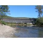
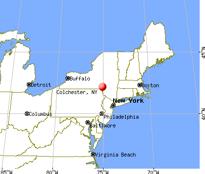
Colchester, New York
Submit your own pictures of this town and show them to the world
- OSM Map
- General Map
- Google Map
- MSN Map
Population change since 2000: +1.7%
 |
| Males: 1,057 | |
| Females: 1,020 |
| Median resident age: | 48.9 years |
| New York median age: | 40.7 years |
Zip codes: 12776.
| Colchester: | $56,475 |
| NY: | $79,557 |
Estimated per capita income in 2022: $30,185 (it was $15,636 in 2000)
Colchester town income, earnings, and wages data
Estimated median house or condo value in 2022: $151,783 (it was $67,900 in 2000)
| Colchester: | $151,783 |
| NY: | $400,400 |
Mean prices in 2022: all housing units: $272,591; detached houses: $254,359; townhouses or other attached units: $225,571; in 2-unit structures: $277,007; in 3-to-4-unit structures: $721,615; in 5-or-more-unit structures: $247,836; mobile homes: $89,185
Detailed information about poverty and poor residents in Colchester, NY


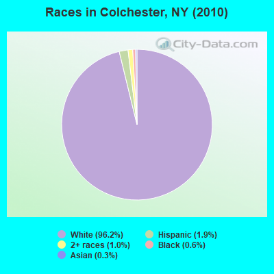
- 1,99896.2%White alone
- 391.9%Hispanic
- 201.0%Two or more races
- 120.6%Black alone
- 60.3%Asian alone
- 20.10%American Indian alone
Races in Colchester detailed stats: ancestries, foreign born residents, place of birth
 Recent articles from our blog. Our writers, many of them Ph.D. graduates or candidates, create easy-to-read articles on a wide variety of topics.


 | Syracuse Construction Update (4334 replies) |
| sullivan county vs delaware county (7 replies) |
| I am a Saranac Lake native wanting to move back north, am I crazy? (4 replies) |
| I-84 & Connecticut Route 2 instead of I-95 to Providence? (5 replies) |
| Why ithaca? (42 replies) |
| Moving to Adirondacks from NYC (78 replies) |
Latest news from Colchester, NY collected exclusively by city-data.com from local newspapers, TV, and radio stations
Ancestries: German (21.0%), Irish (17.2%), Italian (13.6%), English (12.2%), United States (6.1%), Dutch (6.0%).
Current Local Time: EST time zone
Land area: 137.4 square miles.
Population density: 15 people per square mile (very low).
43 residents are foreign born (1.9% Europe).
| This town: | 2.1% |
| New York: | 20.4% |
| Colchester town: | 1.2% ($796) |
| New York: | 1.9% ($2,847) |
Nearest city with pop. 50,000+: Union, NY (54.5 miles  , pop. 56,298).
Nearest city with pop. 200,000+: Newark, NJ (98.2 miles , pop. 273,546).
Nearest city with pop. 1,000,000+: Bronx, NY (99.5 miles , pop. 1,332,650).
Nearest cities:
), ), ), ), ), Latitude: 42.03 N, Longitude: 74.97 W
Area code commonly used in this area: 607


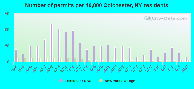
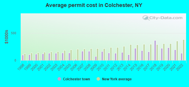
Single-family new house construction building permits:
- 2022: 3 buildings, average cost: $135,000
- 2021: 6 buildings, average cost: $194,500
- 2020: 9 buildings, average cost: $236,700
- 2019: 6 buildings, average cost: $223,200
- 2018: 3 buildings, average cost: $367,700
- 2017: 8 buildings, average cost: $160,600
- 2016: 4 buildings, average cost: $180,000
- 2015: 3 buildings, average cost: $225,000
- 2014: 9 buildings, average cost: $107,200
- 2013: 10 buildings, average cost: $150,300
- 2012: 9 buildings, average cost: $130,600
- 2011: 11 buildings, average cost: $138,600
- 2010: 10 buildings, average cost: $165,900
- 2009: 10 buildings, average cost: $74,900
- 2008: 8 buildings, average cost: $168,800
- 2007: 12 buildings, average cost: $168,800
- 2006: 20 buildings, average cost: $20,200
- 2005: 19 buildings, average cost: $138,800
- 2004: 21 buildings, average cost: $138,800
- 2003: 24 buildings, average cost: $132,800
- 2002: 14 buildings, average cost: $130,700
- 2001: 10 buildings, average cost: $121,400
- 2000: 10 buildings, average cost: $118,000
- 1999: 5 buildings, average cost: $109,200
- 1998: 8 buildings, average cost: $101,700
| Here: | 4.7% |
| New York: | 4.4% |
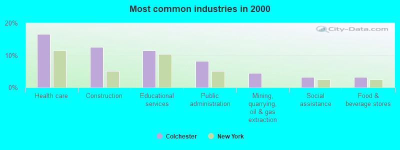
- Health care (16.6%)
- Construction (12.6%)
- Educational services (11.5%)
- Public administration (8.2%)
- Mining, quarrying, oil & gas extraction (4.5%)
- Social assistance (3.3%)
- Food & beverage stores (3.3%)
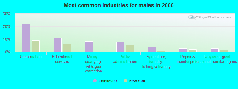
- Construction (21.9%)
- Educational services (10.8%)
- Mining, quarrying, oil & gas extraction (8.4%)
- Public administration (7.7%)
- Agriculture, forestry, fishing & hunting (3.6%)
- Repair & maintenance (2.9%)
- Religious, grantmaking, civic, professional, similar organizations (2.9%)
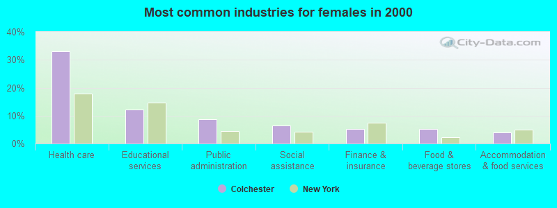
- Health care (33.1%)
- Educational services (12.2%)
- Public administration (8.7%)
- Social assistance (6.5%)
- Finance & insurance (5.1%)
- Food & beverage stores (5.1%)
- Accommodation & food services (4.1%)
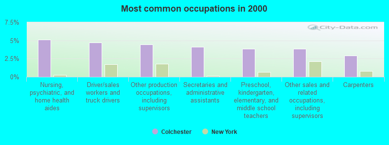
- Nursing, psychiatric, and home health aides (5.1%)
- Driver/sales workers and truck drivers (4.7%)
- Other production occupations, including supervisors (4.5%)
- Secretaries and administrative assistants (4.1%)
- Preschool, kindergarten, elementary, and middle school teachers (3.8%)
- Other sales and related occupations, including supervisors (3.8%)
- Carpenters (2.9%)
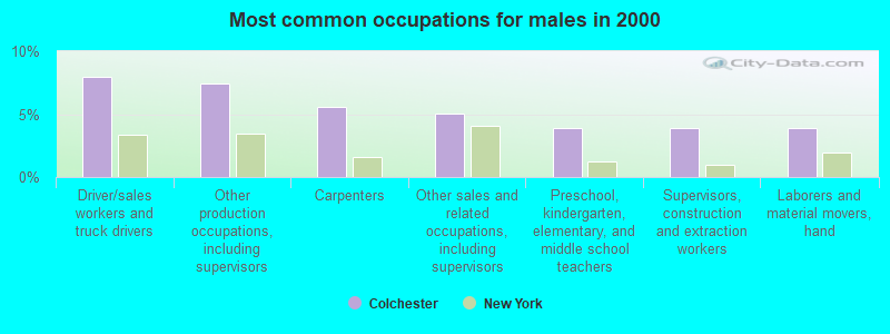
- Driver/sales workers and truck drivers (8.0%)
- Other production occupations, including supervisors (7.5%)
- Carpenters (5.5%)
- Other sales and related occupations, including supervisors (5.1%)
- Preschool, kindergarten, elementary, and middle school teachers (3.9%)
- Supervisors, construction and extraction workers (3.9%)
- Laborers and material movers, hand (3.9%)
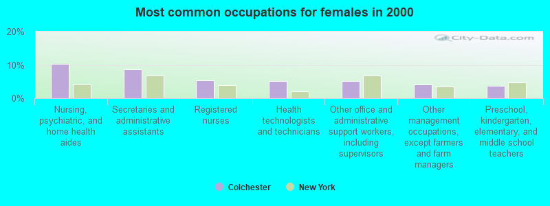
- Nursing, psychiatric, and home health aides (10.3%)
- Secretaries and administrative assistants (8.7%)
- Registered nurses (5.4%)
- Health technologists and technicians (5.1%)
- Other office and administrative support workers, including supervisors (5.1%)
- Other management occupations, except farmers and farm managers (4.1%)
- Preschool, kindergarten, elementary, and middle school teachers (3.8%)
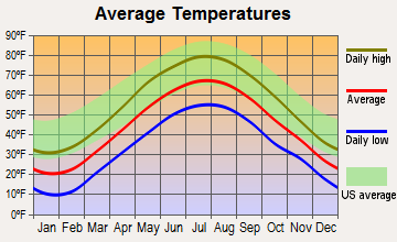
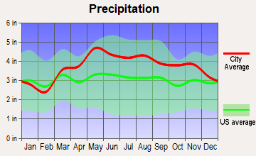
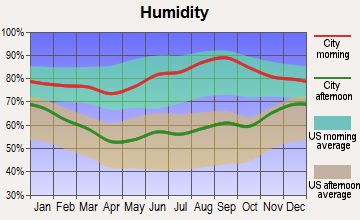
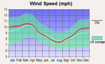
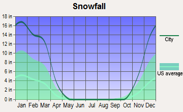
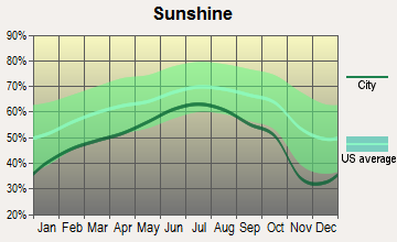
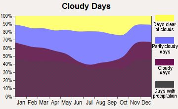
Average climate in Colchester, New York
Based on data reported by over 4,000 weather stations
Tornado activity:
Colchester-area historical tornado activity is slightly above New York state average. It is 56% smaller than the overall U.S. average.
On 5/31/1998, a category F3 (max. wind speeds 158-206 mph) tornado 3.9 miles away from the Colchester town center injured 12 people and caused $3 million in damages.
On 5/31/1998, a category F3 tornado 35.3 miles away from the town center injured 3 people and caused $800,000 in damages.
Earthquake activity:
Colchester-area historical earthquake activity is significantly above New York state average. It is 67% smaller than the overall U.S. average.On 10/7/1983 at 10:18:46, a magnitude 5.3 (5.1 MB, 5.3 LG, 5.1 ML, Class: Moderate, Intensity: VI - VII) earthquake occurred 136.8 miles away from Colchester center
On 4/20/2002 at 10:50:47, a magnitude 5.3 (5.3 ML, Depth: 3.0 mi) earthquake occurred 183.2 miles away from Colchester center
On 4/20/2002 at 10:50:47, a magnitude 5.2 (5.2 MB, 4.2 MS, 5.2 MW, 5.0 MW) earthquake occurred 181.2 miles away from the city center
On 8/23/2011 at 17:51:04, a magnitude 5.8 (5.8 MW, Depth: 3.7 mi) earthquake occurred 325.5 miles away from the city center
On 1/16/1994 at 01:49:16, a magnitude 4.6 (4.6 MB, 4.6 LG, Depth: 3.1 mi, Class: Light, Intensity: IV - V) earthquake occurred 130.1 miles away from the city center
On 6/17/1991 at 08:53:16, a magnitude 4.1 (4.0 MB, 4.0 LG, Depth: 3.1 mi) earthquake occurred 44.1 miles away from the city center
Magnitude types: regional Lg-wave magnitude (LG), body-wave magnitude (MB), local magnitude (ML), surface-wave magnitude (MS), moment magnitude (MW)
Natural disasters:
The number of natural disasters in Delaware County (36) is a lot greater than the US average (15).Major Disasters (Presidential) Declared: 24
Emergencies Declared: 10
Causes of natural disasters: Floods: 17, Storms: 15, Hurricanes: 4, Snowstorms: 3, Winter Storms: 3, Blizzards: 2, Tornadoes: 2, Tropical Storms: 2, Heavy Rain: 1, Power Outage: 1, Tropical Depression: 1, Water Shortage: 1, Wind: 1, Other: 3 (Note: some incidents may be assigned to more than one category).
Colleges/universities with over 2000 students nearest to Colchester:
- SUNY College of Technology at Delhi (about 17 miles; Delhi, NY; Full-time enrollment: 2,911)
- SUNY Oneonta (about 31 miles; Oneonta, NY; FT enrollment: 6,081)
- Ulster County Community College (about 45 miles; Stone Ridge, NY; FT enrollment: 2,207)
- SUNY Broome Community College (about 50 miles; Binghamton, NY; FT enrollment: 4,969)
- Orange County Community College (about 50 miles; Middletown, NY; FT enrollment: 4,742)
- State University of New York at New Paltz (about 50 miles; New Paltz, NY; FT enrollment: 7,319)
- SUNY College of Agriculture and Technology at Cobleskill (about 50 miles; Cobleskill, NY; FT enrollment: 2,455)
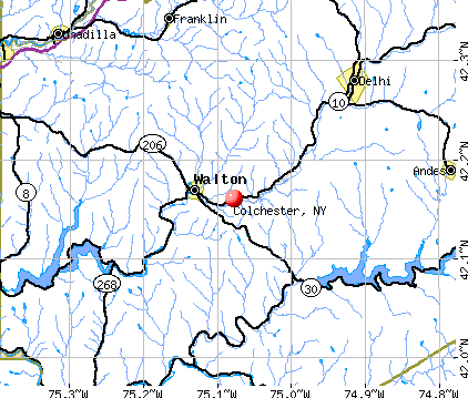
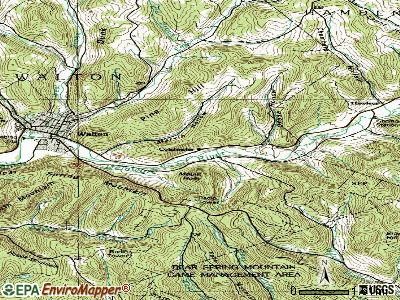
Points of interest:
Notable locations in Colchester: Air Shaft Number 3 (A), Camp Highmount (B), Downsville Fire Station (C). Display/hide their locations on the map
Church in Colchester: Horton Brook Church (A). Display/hide its location on the map
Cemeteries: Horton Cemetery (1), Gregorytown Cemetery (2), Paige Cemetery (3), Wilson Hollow Cemetery (4). Display/hide their locations on the map
Lakes: Lake Mimi (A), Mountain Lake (B), Mud Pond (C), Quinn Lake (D), Stuart Lake (E), Cables Lake (F), Edwards Pond (G), Huggins Lake (H). Display/hide their locations on the map
Streams, rivers, and creeks: Tub Mill Brook (A), Trout Brook (B), Wilson Hollow Brook (C), Flynn Brook (D), Bryden Hill Brook (E), Downs Brook (F), Roaring Brook (G), Doe Brook (H), Spooner Brook (I). Display/hide their locations on the map
Park in Colchester: Bear Spring Mountain Game Management Area (1). Display/hide its location on the map
| This town: | 2.2 people |
| New York: | 2.6 people |
| This town: | 61.6% |
| Whole state: | 63.5% |
| This town: | 7.0% |
| Whole state: | 6.8% |
Likely homosexual households (counted as self-reported same-sex unmarried-partner households)
- Lesbian couples: 0.3% of all households
- Gay men: 0.2% of all households
| This town: | 12.7% |
| Whole state: | 14.6% |
| This town: | 4.8% |
| Whole state: | 7.4% |
3 people in correctional residential facilities in 2010
93 people in nursing homes in 2000
3 people in homes for the mentally retarded in 2000
For population 15 years and over in Colchester:
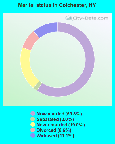
- Never married: 19.0%
- Now married: 59.3%
- Separated: 2.0%
- Widowed: 11.1%
- Divorced: 8.6%
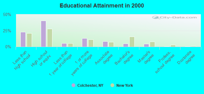
For population 25 years and over in Colchester:
- High school or higher: 77.1%
- Bachelor's degree or higher: 10.2%
- Graduate or professional degree: 5.2%
- Unemployed: 7.4%
- Mean travel time to work (commute): 32.0 minutes
| Here: | 11.3 |
| New York average: | 14.2 |
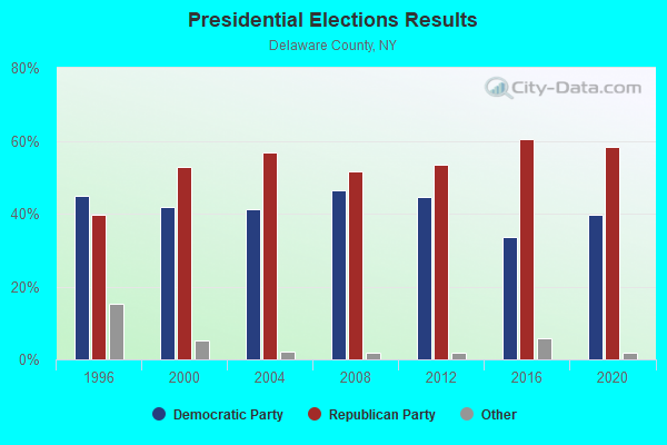
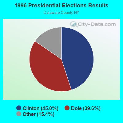
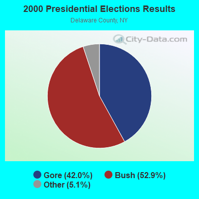
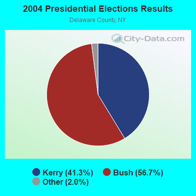
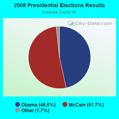
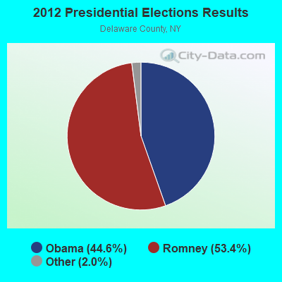
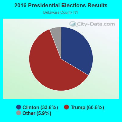
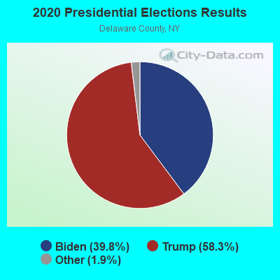
Graphs represent county-level data. Detailed 2008 Election Results
Religion statistics for Colchester, NY (based on Delaware County data)
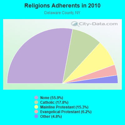
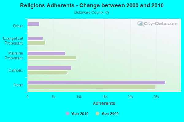
| Religion | Adherents | Congregations |
|---|---|---|
| Catholic | 8,538 | 9 |
| Mainline Protestant | 7,325 | 65 |
| Evangelical Protestant | 2,951 | 30 |
| Other | 2,327 | 10 |
| Orthodox | 12 | 1 |
| None | 26,827 | - |
Food Environment Statistics:
| Delaware County: | 3.02 / 10,000 pop. |
| State: | 4.13 / 10,000 pop. |
| This county: | 0.43 / 10,000 pop. |
| New York: | 0.92 / 10,000 pop. |
| This county: | 7.56 / 10,000 pop. |
| New York: | 1.68 / 10,000 pop. |
| Delaware County: | 12.09 / 10,000 pop. |
| New York: | 8.82 / 10,000 pop. |
| Delaware County: | 8.2% |
| New York: | 8.2% |
| Delaware County: | 25.3% |
| New York: | 23.8% |
| Delaware County: | 17.0% |
| State: | 15.6% |
Strongest AM radio stations in Colchester:
- WDLA (1270 AM; 5 kW; WALTON, NY; Owner: BANJO COMMUNICATIONS GROUP, INC.)
- WGY (810 AM; 50 kW; SCHENECTADY, NY; Owner: CLEAR CHANNEL BROADCASTING LICENSES, INC.)
- WMCA (570 AM; 50 kW; NEW YORK, NY; Owner: SALEM MEDIA OF NEW YORK, LLC)
- WABC (770 AM; 50 kW; NEW YORK, NY; Owner: WABC-AM RADIO, INC.)
- WOR (710 AM; 50 kW; NEW YORK, NY; Owner: BUCKLEY BROADCASTING CORPORATION)
- WFAN (660 AM; 50 kW; NEW YORK, NY; Owner: INFINITY BROADCASTING OPERATIONS, INC.)
- WPTR (1540 AM; 50 kW; ALBANY, NY; Owner: KIMTRON, INC.)
- WNNZ (640 AM; 50 kW; WESTFIELD, MA; Owner: CLEAR CHANNEL BROADCASTING LICENSES, INC.)
- WWJZ (640 AM; 50 kW; MOUNT HOLLY, NJ; Owner: ABC, INC.)
- WCBS (880 AM; 50 kW; NEW YORK, NY; Owner: INFINITY BROADCASTING OPERATIONS, INC.)
- WINS (1010 AM; 50 kW; NEW YORK, NY; Owner: INFINITY BROADCASTING OPERATIONS, INC.)
- WEPN (1050 AM; 50 kW; NEW YORK, NY; Owner: NEW YORK AM RADIO, LLC)
- WBBR (1130 AM; 50 kW; NEW YORK, NY; Owner: BLOOMBERG COMMUNICATIONS INC.)
Strongest FM radio stations in Colchester:
- WDLA-FM (92.1 FM; WALTON, NY; Owner: BANJO COMMUNICATIONS GROUP, INC.)
- WJFF (90.5 FM; JEFFERSONVILLE, NY; Owner: RADIO CATSKILL)
- WGKR (105.3 FM; GRAND GORGE, NY; Owner: SOUND OF LIFE, INC.)
- WPDA (106.1 FM; JEFFERSONVILLE, NY; Owner: CUMULUS LICENSING CORP.)
- WFKP (99.3 FM; ELLENVILLE, NY; Owner: CLEAR CHANNEL BROADCASTING LICENSES, INC.)
- WGWR (88.1 FM; LIBERTY, NY; Owner: SOUND OF LIFE, INC.)
- WAMK (90.9 FM; KINGSTON, NY; Owner: W A M C)
- WFGB (89.7 FM; KINGSTON, NY; Owner: SOUND OF LIFE, INC.)
- WDHI (100.3 FM; DELHI, NY; Owner: BANJO COMMUNICATIONS GROUP, INC.)
- WIYN (94.7 FM; DEPOSIT, NY; Owner: BANJO COMMUNICATIONS GROUP, INC.)
- WRIP (97.9 FM; WINDHAM, NY; Owner: RIP RADIO, LLC)
- WPDH (101.5 FM; POUGHKEEPSIE, NY; Owner: CUMULUS LICENSING CORP.)
- WPGP (88.3 FM; TAFTON, PA; Owner: SOUND OF LIFE, INC.)
- WQFN (100.1 FM; FOREST CITY, PA; Owner: THE SCRANTON TIMES, L.P.)
- WHWK (98.1 FM; BINGHAMTON, NY; Owner: CITADEL BROADCASTING COMPANY)
- WCDO-FM (100.9 FM; SIDNEY, NY; Owner: CDO BROADCASTING, INC.)
- WSQC-FM (91.7 FM; ONEONTA, NY; Owner: WSKG PUBLIC TELECOMM. COUNCIL)
- WSRK (103.9 FM; ONEONTA, NY; Owner: ULTIMATE B/CASTING NETWORK, INC.)
- WBKT (95.3 FM; NORWICH, NY; Owner: BANJO COMMUNICATIONS GROUP, INC)
- WSUL (98.3 FM; MONTICELLO, NY; Owner: REYNOLDS COMMUNICATIONS, INC.)
- National Bridge Inventory (NBI) Statistics
- 70Number of bridges
- 886ft / 270mTotal length
- $111,054,000Total costs
- 53,307Total average daily traffic
- 9,272Total average daily truck traffic
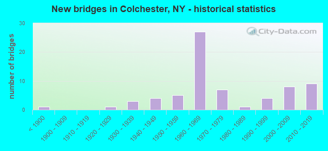
- New bridges - historical statistics
- 1Before 1900
- 11920-1929
- 31930-1939
- 41940-1949
- 51950-1959
- 271960-1969
- 71970-1979
- 11980-1989
- 41990-1999
- 82000-2009
- 92010-2019
FCC Registered Broadcast Land Mobile Towers:
1- Outlet Chamber West End Downsville Dam (Lat: 42.075083 Lon: -74.966278), Call Sign: KCK821,
Assigned Frequencies: 37.5000 MHz, 47.9600 MHz, Grant Date: 11/21/2020, Expiration Date: 01/15/2031, Registrant: Nyc Doitt - Fcc Licensing (Wireless Technologies), 15 Metrotech Center, 18th Floor, Brooklyn, NY 11201, Phone: (718) 403-6742, Email:
FCC Registered Paging Towers:
1- (Lat: 41.995083 Lon: -74.916250), Call Sign: KEJ902, Licensee ID: L00003022,
Assigned Frequencies: 152.690 MHz, Expiration Date: 07/01/1998, Cancellation Date: 04/05/1999, Registrant: Citizens Telecommunications Company Of N, 850 Harrison Street Extension, Johnstown, NY 12095
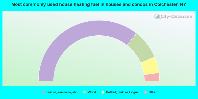
- 71.2%Fuel oil, kerosene, etc.
- 15.8%Wood
- 8.7%Bottled, tank, or LP gas
- 3.0%Electricity
- 0.7%Other fuel
- 0.3%Utility gas
- 0.3%Coal or coke
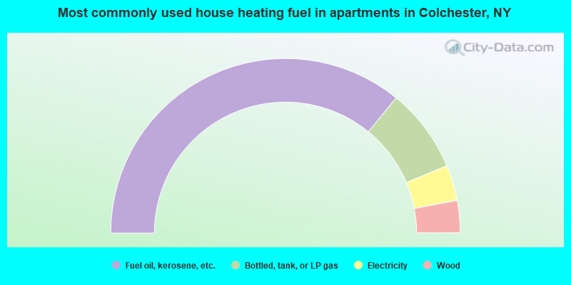
- 71.9%Fuel oil, kerosene, etc.
- 15.6%Bottled, tank, or LP gas
- 6.6%Electricity
- 6.0%Wood
Colchester compared to New York state average:
- Median house value significantly below state average.
- Unemployed percentage below state average.
- Black race population percentage significantly below state average.
- Hispanic race population percentage significantly below state average.
- Median age significantly above state average.
- Foreign-born population percentage significantly below state average.
- Renting percentage significantly below state average.
- Length of stay since moving in significantly above state average.
- Number of rooms per house significantly below state average.
- House age significantly below state average.
- Institutionalized population percentage above state average.
- Number of college students below state average.
- Percentage of population with a bachelor's degree or higher significantly below state average.