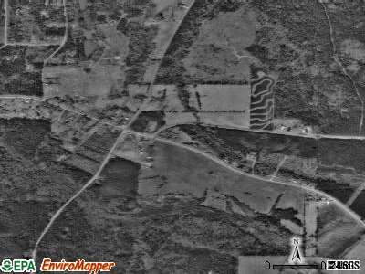
Corinth, Georgia
Submit your own pictures of this town and show them to the world
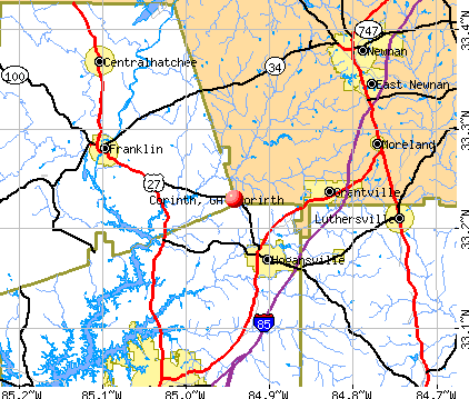
- OSM Map
- General Map
- Google Map
- MSN Map
| Males: 105 | |
| Females: 114 |
| Median resident age: | 29.8 years |
| Georgia median age: | 33.4 years |
Zip codes: 30230.
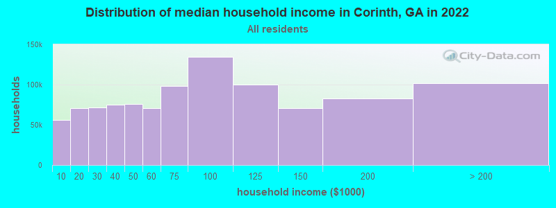
| Corinth: | $41,037 |
| GA: | $72,837 |
Estimated per capita income in 2022: $25,669 (it was $11,824 in 2000)
Corinth town income, earnings, and wages data
Estimated median house or condo value in 2022: $54,631 (it was $22,100 in 2000)
| Corinth: | $54,631 |
| GA: | $297,400 |
Mean prices in 2022: all housing units: $155,763; detached houses: $184,537; townhouses or other attached units: $163,560; mobile homes: $93,881
Detailed information about poverty and poor residents in Corinth, GA
Compare current foreclosures near Corinth, GA:
| Photo | Address | Area | Beds / Baths | Price | Details |
|---|---|---|---|---|---|

|
#1
Eichelberger Dr
Lagrange, GA 30241
|
1,396 sq. feet
|
1 baths 3 beds |
$68,250
|
show details |

|
#2
Stonebridge Xing
Newnan, GA 30265
|
1,680 sq. feet
|
3 baths 3 beds |
show details | |

|
#3
Forest Rd
Greenville, GA 30222
|
1,985 sq. feet
|
2 baths 3 beds |
show details | |

|
#4
Askew Ave
Hogansville, GA 30230
|
1,300 sq. feet
|
1 baths 2 beds |
show details | |

|
#5
Meadowland Trl
Lagrange, GA 30240
|
1,668 sq. feet
|
2 baths 3 beds |
show details | |

|
#6
Highway 54 W
Hogansville, GA 30230
|
1,496 sq. feet
|
1 baths 3 beds |
show details | |

|
#7
Lake Cir
Carrollton, GA 30116
|
3,969 sq. feet
|
5 baths 5 beds |
show details | |

|
#8
Olmstead Trce
Newnan, GA 30263
|
3,286 sq. feet
|
2 baths 3 beds |
show details | |

|
#9
Old Carrollton Rd
Newnan, GA 30263
|
1,667 sq. feet
|
2 baths 3 beds |
show details | |

|
#10
Us Highway 27
Franklin, GA 30217
|
2,398 sq. feet
|
3 baths 4 beds |
show details |
| Photo | Address | Area | Beds / Baths | Price | Details |
|---|---|---|---|---|---|

|
#11
Lincoln St
Hogansville, GA 30230
|
1,479 sq. feet
|
2 baths 3 beds |
show details | |

|
#12
Luthersville Rd
Luthersville, GA 30251
|
1,596 sq. feet
|
2 baths 3 beds |
show details | |

|
#13
Charlie Fuller Rd
Grantville, GA 30220
|
1,416 sq. feet
|
2 baths 3 beds |
show details | |

|
#14
Yarmouth Ct
Lagrange, GA 30240
|
1,080 sq. feet
|
2 baths 3 beds |
show details | |

|
#15
W Oak St
Luthersville, GA 30251
|
2,934 sq. feet
|
2 baths 6 beds |
show details | |

|
#16
Luthersville Rd
Luthersville, GA 30251
|
1,485 sq. feet
|
2 baths 3 beds |
show details | |

|
#17
Baldwin Ct
Newnan, GA 30263
|
1,893 sq. feet
|
2 baths 3 beds |
show details | |

|
#18
Glavine St
Greenville, GA 30222
|
2,356 sq. feet
|
2 baths 3 beds |
show details | |

|
#19
Wesley Dr
Luthersville, GA 30251
|
1,088 sq. feet
|
1 baths 3 beds |
show details | |

|
#20
Bishop Rd
Luthersville, GA 30251
|
2,015 sq. feet
|
2 baths 3 beds |
show details |
| Photo | Address | Area | Beds / Baths | Price | Details |
|---|---|---|---|---|---|

|
#21
Georgia Highway 100
Hogansville, GA 30230
|
1,896 sq. feet
|
2 baths 4 beds |
show details | |

|
#22
Forest Rd
Greenville, GA 30222
|
2,033 sq. feet
|
2 baths 3 beds |
show details | |

|
#23
Boggus Rd
Franklin, GA 30217
|
1,044 sq. feet
|
2 baths 3 beds |
show details | |

|
#24
Todd Rd
Greenville, GA 30222
|
1,116 sq. feet
|
2 baths 3 beds |
show details | |

|
#25
W Oak St
Luthersville, GA 30251
|
1,008 sq. feet
|
1 baths 2 beds |
show details | |

|
#26
Birch Rd
Franklin, GA 30217
|
1,970 sq. feet
|
2 baths 3 beds |
show details | |

|
#27
Primrose Rd
Greenville, GA 30222
|
1,104 sq. feet
|
1 baths 3 beds |
show details | |

|
#28
Frolona Rd
Franklin, GA 30217
|
864 sq. feet
|
1 baths 2 beds |
show details | |

|
#29
Pulpwood Ln
Greenville, GA 30222
|
1,520 sq. feet
|
1 baths 3 beds |
show details | |

|
#30
Simpson Rd
Franklin, GA 30217
|
1,440 sq. feet
|
2 baths 4 beds |
show details |
| Photo | Address | Area | Beds / Baths | Price | Details |
|---|---|---|---|---|---|

|
#31
Sunset St
Lagrange, GA 30240
|
812 sq. feet
|
1 baths 2 beds |
show details | |

|
#32
S River Run Dr
Hogansville, GA 30230
|
2,889 sq. feet
|
2 baths 4 beds |
show details | |

|
#33
Elm St
Lagrange, GA 30240
|
1,034 sq. feet
|
1 baths 2 beds |
show details | |

|
#34
Roosterville Rd
Franklin, GA 30217
|
1,600 sq. feet
|
1 baths 3 beds |
show details | |

|
#35
Staples Dairy Rd
Carrollton, GA 30116
|
1,409 sq. feet
|
2 baths 3 beds |
show details | |

|
#36
Stephens Cir
Franklin, GA 30217
|
3,456 sq. feet
|
3 baths 6 beds |
show details | |

|
#37
Jenny D Ln
Hogansville, GA 30230
|
1,836 sq. feet
|
4 baths 3 beds |
show details | |

|
#38
Puckett Dr
Hogansville, GA 30230
|
949 sq. feet
|
2 baths 3 beds |
show details | |

|
#39
Forrest Rd
Hogansville, GA 30230
|
1,604 sq. feet
|
2 baths 3 beds |
show details | |

|
#40
Charlie Fuller Rd
Grantville, GA 30220
|
1,104 sq. feet
|
1 baths 3 beds |
show details |
| Photo | Address | Area | Beds / Baths | Price | Details |
|---|---|---|---|---|---|

|
#41
Pine Cres
Newnan, GA 30265
|
2,598 sq. feet
|
2 baths 3 beds |
show details | |

|
#42
Wentworth Way
Newnan, GA 30265
|
2,522 sq. feet
|
3 baths 3 beds |
show details | |

|
#43
College St
Luthersville, GA 30251
|
1,377 sq. feet
|
1 baths 3 beds |
show details | |

|
#44
Charlie Fuller Rd
Grantville, GA 30220
|
1,510 sq. feet
|
2 baths 3 beds |
show details | |

|
#45
Maple Dr
Hogansville, GA 30230
|
684 sq. feet
|
1 baths 2 beds |
show details | |

|
#46
Mallard Dr
Newnan, GA 30263
|
1,232 sq. feet
|
2 baths 3 beds |
show details | |

|
#47
Charlie Fuller Rd
Grantville, GA 30220
|
1,500 sq. feet
|
2 baths 3 beds |
show details | |

|
#48
Liberty Church Rd
Carrollton, GA 30116
|
840 sq. feet
|
1 baths 2 beds |
show details | |

|
#49
Ferry Rd
Franklin, GA 30217
|
2,400 sq. feet
|
2 baths 3 beds |
show details | |

|
Check over 1 million property listings on Foreclosure.com!
|
browse all offers | |||

- 19792.5%White alone
- 94.2%Black alone
- 73.3%Hispanic
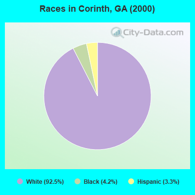
Races in Corinth detailed stats: ancestries, foreign born residents, place of birth
 Recent articles from our blog. Our writers, many of them Ph.D. graduates or candidates, create easy-to-read articles on a wide variety of topics.

 | LaVista Park Petitioning For Brookhaven Annexation (111 replies) |
| Atlanta's suburbs continue to become increasingly sophisticated (1211 replies) |
| Hearings planned on potential Atlanta-Charlotte rail line (209 replies) |
| Leaving the WI Cold to Head South...Racism Issues? (38 replies) |
| Relocating to Lawrenceville (9 replies) |
| Moving To Lawrenceville (1 reply) |
Latest news from Corinth, GA collected exclusively by city-data.com from local newspapers, TV, and radio stations
Ancestries: United States (31.0%), English (8.0%), Irish (7.5%), German (6.6%), French (3.3%), Dutch (2.3%).
Current Local Time: EST time zone
Land area: 0.91 square miles.
Population density: 242 people per square mile (very low).
| Corinth town: | 1.5% ($333) |
| Georgia: | 0.9% ($919) |
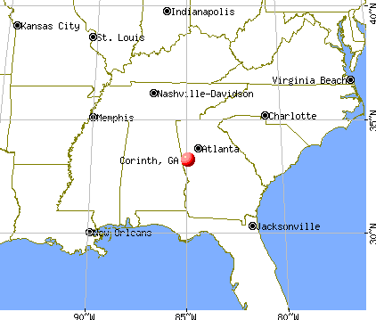
Nearest city with pop. 50,000+: Atlanta, GA  (48.1 miles , pop. 416,474).
Nearest city with pop. 1,000,000+: Chicago, IL (614.1 miles , pop. 2,896,016).
Nearest cities:
), ), )Latitude: 33.23 N, Longitude: 84.94 W
| Here: | 2.7% |
| Georgia: | 2.9% |
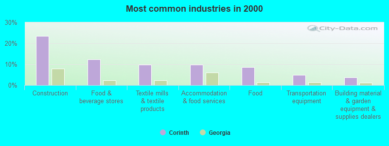
- Construction (23.5%)
- Food & beverage stores (12.3%)
- Textile mills & textile products (9.9%)
- Accommodation & food services (9.9%)
- Food (8.6%)
- Transportation equipment (4.9%)
- Building material & garden equipment & supplies dealers (3.7%)

- Construction (34.7%)
- Food (14.3%)
- Food & beverage stores (12.2%)
- Textile mills & textile products (8.2%)
- Furniture & home furnishings, household appliance stores (6.1%)
- Building material & garden equipment & supplies dealers (6.1%)
- Air transportation (6.1%)
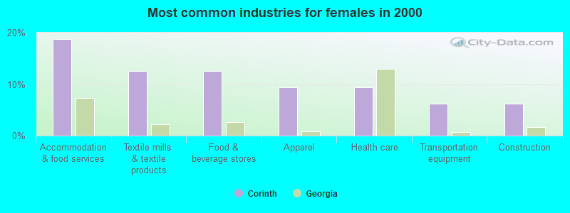
- Accommodation & food services (18.8%)
- Textile mills & textile products (12.5%)
- Food & beverage stores (12.5%)
- Apparel (9.4%)
- Health care (9.4%)
- Transportation equipment (6.2%)
- Construction (6.2%)
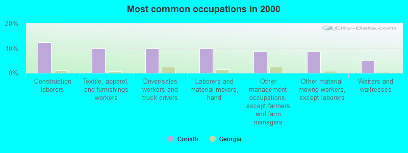
- Construction laborers (12.3%)
- Textile, apparel, and furnishings workers (9.9%)
- Driver/sales workers and truck drivers (9.9%)
- Laborers and material movers, hand (9.9%)
- Other management occupations, except farmers and farm managers (8.6%)
- Other material moving workers, except laborers (8.6%)
- Waiters and waitresses (4.9%)
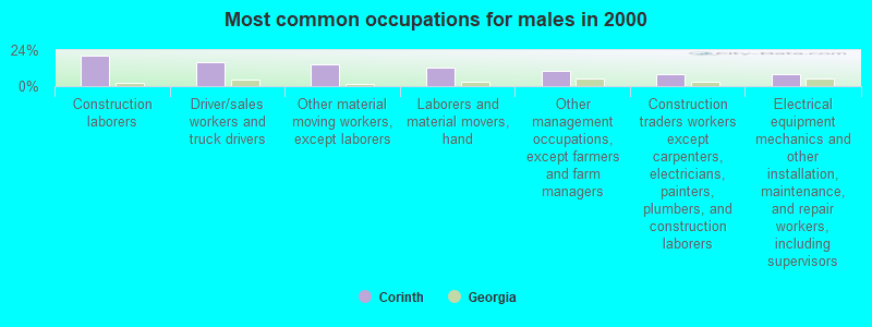
- Construction laborers (20.4%)
- Driver/sales workers and truck drivers (16.3%)
- Other material moving workers, except laborers (14.3%)
- Laborers and material movers, hand (12.2%)
- Other management occupations, except farmers and farm managers (10.2%)
- Construction traders workers except carpenters, electricians, painters, plumbers, and construction laborers (8.2%)
- Electrical equipment mechanics and other installation, maintenance, and repair workers, including supervisors (8.2%)
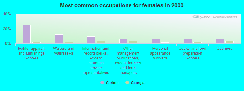
- Textile, apparel, and furnishings workers (25.0%)
- Waiters and waitresses (12.5%)
- Information and record clerks, except customer service representatives (9.4%)
- Other management occupations, except farmers and farm managers (6.2%)
- Personal appearance workers (6.2%)
- Cooks and food preparation workers (6.2%)
- Cashiers (6.2%)
Average climate in Corinth, Georgia
Based on data reported by over 4,000 weather stations


(lower is better)
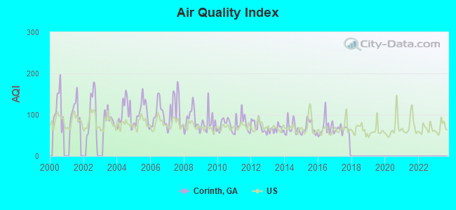
Air Quality Index (AQI) level in 2017 was 64.8. This is about average.
| City: | 64.8 |
| U.S.: | 72.6 |
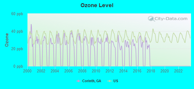
Ozone [ppb] level in 2017 was 24.7. This is better than average. Closest monitor was 16.6 miles away from the city center.
| City: | 24.7 |
| U.S.: | 33.3 |
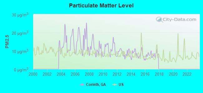
Particulate Matter (PM2.5) [µg/m3] level in 2017 was 7.90. This is about average. There were 0 monitors within city limits.
| City: | 7.90 |
| U.S.: | 8.11 |
Tornado activity:
Corinth-area historical tornado activity is slightly above Georgia state average. It is 58% greater than the overall U.S. average.
On 3/5/1989, a category F3 (max. wind speeds 158-206 mph) tornado 7.4 miles away from the Corinth town center injured 23 people and caused between $5,000,000 and $50,000,000 in damages.
On 4/2/1970, a category F3 tornado 10.8 miles away from the town center caused between $5000 and $50,000 in damages.
Earthquake activity:
Corinth-area historical earthquake activity is significantly above Georgia state average. It is 55% greater than the overall U.S. average.On 4/29/2003 at 08:59:39, a magnitude 4.9 (4.4 MB, 4.6 MW, 4.9 LG, Class: Light, Intensity: IV - V) earthquake occurred 95.9 miles away from the city center
On 8/2/1974 at 08:52:09, a magnitude 4.9 (4.3 MB, 4.9 LG) earthquake occurred 148.3 miles away from the city center
On 1/18/1999 at 07:00:53, a magnitude 4.8 (4.8 MB, 4.0 LG, Depth: 0.6 mi) earthquake occurred 134.2 miles away from Corinth center
On 4/29/2003 at 08:59:39, a magnitude 4.6 (4.6 MW, Depth: 12.3 mi) earthquake occurred 96.0 miles away from the city center
On 10/24/1997 at 08:35:17, a magnitude 4.9 (4.8 MB, 4.2 MS, 4.9 LG, Depth: 6.2 mi) earthquake occurred 199.6 miles away from the city center
On 11/30/1973 at 07:48:41, a magnitude 4.7 (4.7 MB, 4.6 ML) earthquake occurred 186.3 miles away from Corinth center
Magnitude types: regional Lg-wave magnitude (LG), body-wave magnitude (MB), local magnitude (ML), surface-wave magnitude (MS), moment magnitude (MW)
Natural disasters:
The number of natural disasters in Heard County (12) is smaller than the US average (15).Major Disasters (Presidential) Declared: 8
Emergencies Declared: 3
Causes of natural disasters: Floods: 4, Storms: 4, Tornadoes: 4, Hurricanes: 3, Winds: 2, Winter Storms: 2, Drought: 1, Heavy Rain: 1, Other: 1 (Note: some incidents may be assigned to more than one category).
Hospitals and medical centers near Corinth:
- HERITAGE HEALTHCARE OF FRANKLIN (Nursing Home, about 10 miles away; FRANKLIN, GA)
- AVALON HEALTH AND REHABILITATION (Nursing Home, about 13 miles away; NEWNAN, GA)
- STARCREST OF NEWNAN (Nursing Home, about 13 miles away; NEWNAN, GA)
- ROYAL ELAINE ICF (Nursing Home, about 13 miles away; LAGRANGE, GA)
- TWIN FOUNTAINS HOME (Nursing Home, about 13 miles away; LAGRANGE, GA)
- CROSSPOINT HEALTH CARE, INC (Hospital, about 13 miles away; NEWNAN, GA)
- GEORGIA BAPTIST HOSPICE (Hospital, about 14 miles away; NEWNAN, GA)
Colleges/universities with over 2000 students nearest to Corinth:
- University of West Georgia (about 26 miles; Carrollton, GA; Full-time enrollment: 10,358)
- West Georgia Technical College (about 35 miles; Waco, GA; FT enrollment: 4,768)
- Southern Union State Community College (about 38 miles; Wadley, AL; FT enrollment: 4,120)
- Southern Crescent Technical College (about 38 miles; Griffin, GA; FT enrollment: 4,168)
- Clayton State University (about 44 miles; Morrow, GA; FT enrollment: 5,844)
- Atlanta Metropolitan State College (about 46 miles; Atlanta, GA; FT enrollment: 2,437)
- Atlanta Technical College (about 46 miles; Atlanta, GA; FT enrollment: 4,217)
Points of interest:
Churches in Corinth include: Mount Zion Church (A), Walley Chapel (B), Corinth United Methodist Church (C), Corinth Baptist Church (D). Display/hide their locations on the map
Cemeteries: Corinth Cemetery (1), Mount Zion Cemetery (2), Walley Chapel Cemetery (3). Display/hide their locations on the map
| This town: | 2.7 people |
| Georgia: | 2.6 people |
| This town: | 78.2% |
| Whole state: | 70.7% |
| This town: | 6.4% |
| Whole state: | 4.8% |
Likely homosexual households (counted as self-reported same-sex unmarried-partner households)
- Lesbian couples: 1.3% of all households
- Gay men: 0.0% of all households
| This town: | 29.5% |
| Whole state: | 13.0% |
| This town: | 21.2% |
| Whole state: | 6.1% |
For population 15 years and over in Corinth:
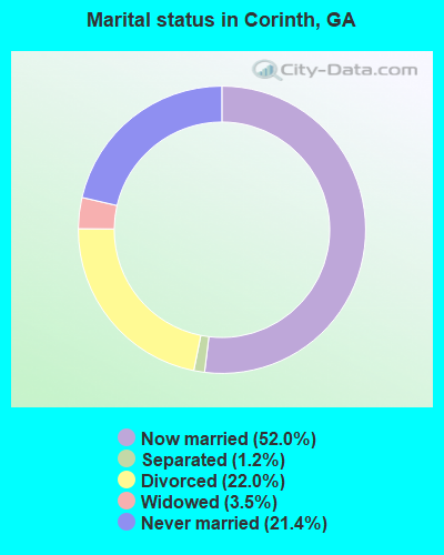
- Never married: 21.4%
- Now married: 52.0%
- Separated: 1.2%
- Widowed: 3.5%
- Divorced: 22.0%
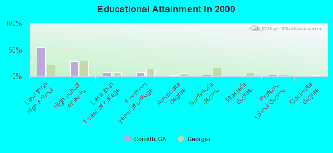
For population 25 years and over in Corinth:
- High school or higher: 46.0%
- Bachelor's degree or higher: 3.6%
- Graduate or professional degree: 1.5%
- Unemployed: 5.8%
- Mean travel time to work (commute): 44.1 minutes
| Here: | 12.2 |
| Georgia average: | 13.3 |
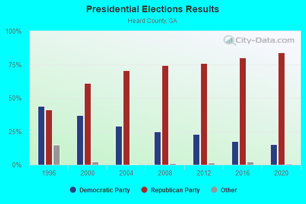
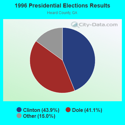
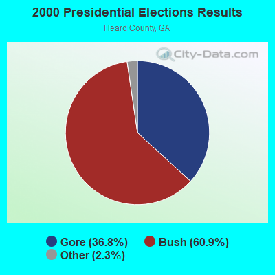
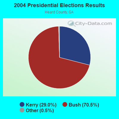
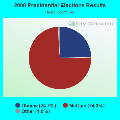
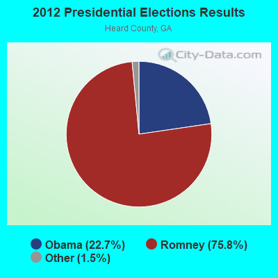
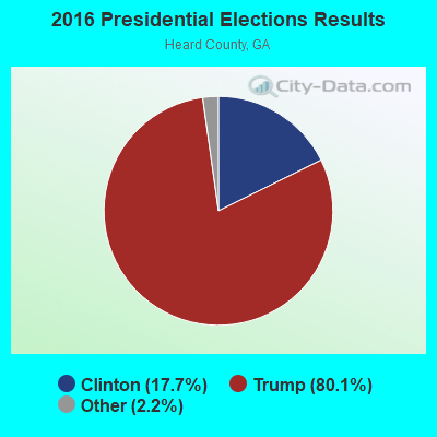
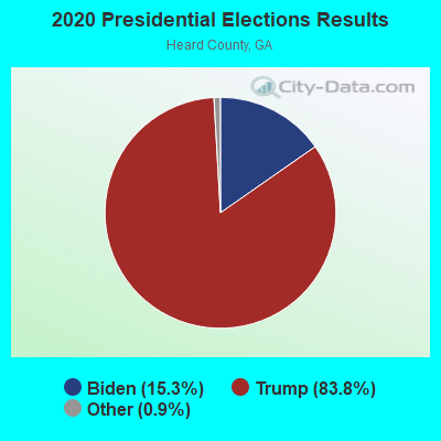
Graphs represent county-level data. Detailed 2008 Election Results
Religion statistics for Corinth, GA (based on Heard County data)
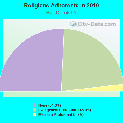
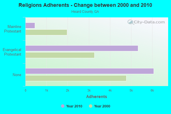
| Religion | Adherents | Congregations |
|---|---|---|
| Evangelical Protestant | 5,322 | 26 |
| Mainline Protestant | 438 | 7 |
| Other | 4 | 1 |
| Black Protestant | - | 1 |
| None | 6,070 | - |
Food Environment Statistics:
| This county: | 3.52 / 10,000 pop. |
| State: | 1.91 / 10,000 pop. |
| Here: | 5.28 / 10,000 pop. |
| Georgia: | 5.12 / 10,000 pop. |
| Here: | 0.88 / 10,000 pop. |
| State: | 7.41 / 10,000 pop. |
| Heard County: | 11.1% |
| Georgia: | 10.4% |
| Heard County: | 27.5% |
| Georgia: | 27.8% |
| Here: | 12.9% |
| Georgia: | 14.6% |
Strongest AM radio stations in Corinth:
- WGSE (720 AM; daytime; 8 kW; HOGANSVILLE, GA; Owner: CITICASTERS LICENSES, L.P.)
- WGST (640 AM; 50 kW; ATLANTA, GA; Owner: CITICASTERS LICENSES, L.P.)
- WKNG (1060 AM; daytime; 50 kW; TALLAPOOSA, GA; Owner: WKNG, INC.)
- WMLB (1160 AM; 50 kW; EAST POINT, GA; Owner: ATLANTA AREA BROADCASTING, INC.)
- WGUN (1010 AM; 50 kW; ATLANTA, GA; Owner: WGUN, INC.)
- WSB (750 AM; 50 kW; ATLANTA, GA; Owner: CXR HOLDINGS, INC.)
- WAOK (1380 AM; 50 kW; ATLANTA, GA; Owner: INFINITY BROADCASTING OPERATIONS, INC.)
- WCNN (680 AM; 50 kW; NORTH ATLANTA, GA; Owner: DICKEY BROADCASTING COMPANY)
- WNSI (810 AM; 50 kW; JACKSONVILLE, AL; Owner: UNITED BROADCASTING NETWORK, INC.)
- WFTD (1080 AM; daytime; 50 kW; MARIETTA, GA; Owner: PRIETO ENTERPRISES, INC.)
- WQXI (790 AM; 28 kW; ATLANTA, GA; Owner: JEFFERSON-PILOT COMMUNICATIONS COMPANY OF GEORGIA)
- WAZX (1550 AM; 50 kW; SMYRNA, GA; Owner: GA-MEX BROADCASTING, INC.)
- WMAC (940 AM; 50 kW; MACON, GA; Owner: CUMULUS LICENSING CORP.)
Strongest FM radio stations in Corinth:
- WALR-FM (104.1 FM; LA GRANGE, GA; Owner: CXR HOLDINGS, INC.)
- WVFJ-FM (93.3 FM; MANCHESTER, GA; Owner: PROVIDENT BROADCASTING COMPANY)
- WMAX-FM (105.3 FM; BOWDON, GA; Owner: CLEAR CHANNEL BROADCASTING LICENSES, INC.)
- WMGP (98.1 FM; HOGANSVILLE, GA; Owner: CITICASTERS LICENSES, L.P.)
- WJSP-FM (88.1 FM; WARM SPRINGS, GA; Owner: GEORGIA PUBLIC TELECOMMUNICATIONS COMMISSION)
- WBZY-FM (96.7 FM; PEACHTREE CITY, GA; Owner: CITICASTERS LICENSES, L.P.)
- WBTR-FM (92.1 FM; CARROLLTON, GA; Owner: WYAI, INC.)
- WKZJ (95.7 FM; GREENVILLE, GA; Owner: DAVIS B/CASTING OF COLUMBUS, INC)
- WTBJ (91.3 FM; OXFORD, AL; Owner: TRINITY CHRISTIAN ACADEMY)
- W220AN (91.9 FM; LA GRANGE, ETC., GA; Owner: FAMILY STATIONS, INC.)
- WHTA (107.9 FM; HAMPTON, GA; Owner: RADIO ONE LICENSES, LLC)
- WPZE (97.5 FM; FAYETTEVILLE, GA; Owner: ROA LICENSES, LLC)
- WUWG (90.7 FM; CARROLLTON, GA; Owner: WEST GEORGIA COLLEGE)
- WELR-FM (102.3 FM; ROANOKE, AL; Owner: EAGLE'S NEST, INC.)
- WSTH-FM (106.1 FM; ALEXANDER CITY, AL; Owner: CLEAR CHANNEL BROADCASTING LICENSES, INC.)
- WOAK (90.9 FM; LA GRANGE, GA; Owner: OAKSIDE CHRISTIAN SCHOOL)
- WKEU-FM (88.9 FM; THE ROCK, GA; Owner: GEORGIA FOUNDATION OF PUBLIC BROADCASTING, INC.)
TV broadcast stations around Corinth:
- W04DB (Channel 4; ATLANTA, GA; Owner: VVILPTV, INC.)
- WJSP-TV (Channel 28; COLUMBUS, GA; Owner: GEORGIA PUBLIC TELECOMMUNICATIONS COMMISSION)
- WSWS-TV (Channel 66; OPELIKA, AL; Owner: PAPPAS TELECASTING OF OPELIKA)
- WUVG (Channel 34; ATHENS, GA; Owner: UNIVISION ATLANTA LLC)
- WCAG-LP (Channel 33; LA GRANGE, GA; Owner: GEORGIA-ALABAMA BROADCASTING, INC.)
Corinth fatal accident list:
Jul 27, 1989 11:12 PM, 100, Vehicles: 2, Persons: 6, Fatalities: 1, Drunk persons involved: 1
Aug 19, 1979 09:00 PM, Vehicles: 2, Persons: 2, Fatalities: 1
Mar 29, 1978 08:05 AM, Vehicles: 2, Persons: 2, Fatalities: 1
FCC Registered Cell Phone Towers:
1 (See the full list of FCC Registered Cell Phone Towers in Corinth)FCC Registered Antenna Towers:
17 (See the full list of FCC Registered Antenna Towers)FCC Registered Microwave Towers:
1- CORINTH, 180 Miller Rd (Lat: 33.235389 Lon: -84.946667), Type: Gtower, Structure height: 76.2 m, Overall height: 80.8 m, Call Sign: WMJ481,
Assigned Frequencies: 6286.19 MHz, Grant Date: 01/25/2011, Expiration Date: 02/01/2021, Cancellation Date: 07/20/2018, Certifier: Gregory M Romano, Registrant: Verizon Wireless, 5055 North Point Pkwy, Np2ne Network Engineering, Alpharetta, GA 30022, Phone: (770) 797-1070, Fax: (678) 259-1319, Email:
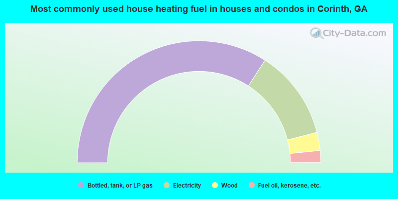
- 68.3%Bottled, tank, or LP gas
- 23.8%Electricity
- 4.8%Wood
- 3.2%Fuel oil, kerosene, etc.
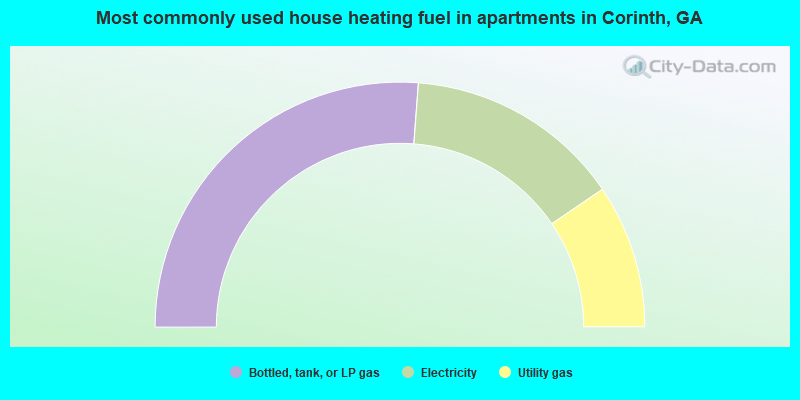
- 52.4%Bottled, tank, or LP gas
- 28.6%Electricity
- 19.0%Utility gas
Corinth compared to Georgia state average:
- Median household income below state average.
- Median house value significantly below state average.
- Unemployed percentage below state average.
- Black race population percentage significantly below state average.
- Hispanic race population percentage significantly below state average.
- Median age significantly below state average.
- Foreign-born population percentage significantly below state average.
- Renting percentage significantly below state average.
- Length of stay since moving in significantly above state average.
- Number of rooms per house significantly below state average.
- House age significantly below state average.
- Number of college students significantly below state average.
- Percentage of population with a bachelor's degree or higher significantly below state average.