Corning, Arkansas
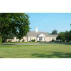
Corning: Public School in Corning AR
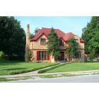
Corning: Home in Corning AR

Corning: Western District Courthouse in Corning AR
- add
your
Submit your own pictures of this city and show them to the world
- OSM Map
- General Map
- Google Map
- MSN Map

Population change since 2000: -14.5%
 |
| Males: 1,524 | |
| Females: 1,621 |
| Median resident age: | 41.3 years |
| Arkansas median age: | 38.9 years |
Zip codes: 72422.
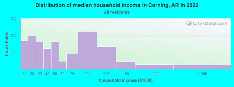
| Corning: | $40,940 |
| AR: | $55,432 |
Estimated per capita income in 2022: $24,657 (it was $12,953 in 2000)
Corning city income, earnings, and wages data
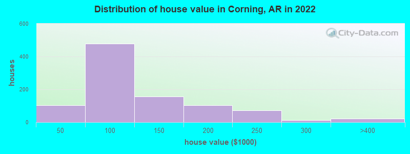
Estimated median house or condo value in 2022: $95,436 (it was $38,100 in 2000)
| Corning: | $95,436 |
| AR: | $179,800 |
Mean prices in 2022: all housing units: $109,639; detached houses: $110,159
Median gross rent in 2022: $499.
(19.7% for White Non-Hispanic residents, 67.3% for two or more races residents)
Detailed information about poverty and poor residents in Corning, AR
Compare current foreclosures near Corning, AR:
| Photo | Address | Area | Beds / Baths | Price | Details |
|---|---|---|---|---|---|

|
#1
Harper St
Corning, AR 72422
|
1,352 sq. feet
|
1 baths 4 beds |
show details | |

|
#2
E Main St
Corning, AR 72422
|
1,156 sq. feet
|
1 baths - beds |
show details | |

|
#3
Irma St
Corning, AR 72422
|
1,040 sq. feet
|
1 baths - beds |
show details | |

|
#4
Polk St
Corning, AR 72422
|
812 sq. feet
|
1 baths - beds |
show details | |

|
#5
W Walnut St
Corning, AR 72422
|
- sq. feet
|
- baths - beds |
show details | |

|
#6
Highway 135 N
Paragould, AR 72450
|
1,494 sq. feet
|
2 baths 2 beds |
show details | |

|
#7
Grandview Rd
Maynard, AR 72444
|
1,441 sq. feet
|
1 baths - beds |
show details | |

|
#8
Mile Rd
Maynard, AR 72444
|
1,404 sq. feet
|
2 baths - beds |
show details | |

|
#9
Old Highway 67
Neelyville, MO 63954
|
- sq. feet
|
- baths - beds |
show details | |

|
#10
Haynes St
Neelyville, MO 63954
|
- sq. feet
|
- baths - beds |
show details |
| Photo | Address | Area | Beds / Baths | Price | Details |
|---|---|---|---|---|---|

|
#11
Ripley Rte E, # 21n-8
Doniphan, MO 63935
|
- sq. feet
|
- baths - beds |
show details | |

|
#12
Maple St
Knobel, AR 72435
|
1,152 sq. feet
|
- baths - beds |
show details | |

|
#13
Ripley 142 E, A 30
Oxly, MO 63955
|
- sq. feet
|
- baths - beds |
show details | |

|
#14
Greene Road 115
Delaplaine, AR 72425
|
- sq. feet
|
- baths - beds |
show details | |

|
#15
Greene 115 Rd
Delaplaine, AR 72425
|
- sq. feet
|
- baths - beds |
show details | |

|
#16
County Road 449
Pollard, AR 72456
|
- sq. feet
|
- baths - beds |
show details | |

|
#17
Gr 225 Rd
Delaplaine, AR 72425
|
- sq. feet
|
- baths - beds |
show details | |

|
#18
Highway 135 N
Lafe, AR 72436
|
- sq. feet
|
- baths - beds |
show details | |

|
#19
Greene Road 502
Lafe, AR 72436
|
- sq. feet
|
- baths - beds |
show details | |

|
#20
Ripley 142e-20
Doniphan, MO 63935
|
- sq. feet
|
- baths - beds |
show details |
| Photo | Address | Area | Beds / Baths | Price | Details |
|---|---|---|---|---|---|

|
Check over 1 million property listings on Foreclosure.com!
|
browse all offers | |||
| Photo | Address | Area | Beds / Baths | Price | Details |
|---|


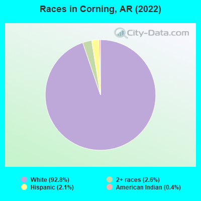
- 2,99792.8%White alone
- 832.6%Two or more races
- 692.1%Hispanic
- 120.4%American Indian alone
According to our research of Arkansas and other state lists, there were 22 registered sex offenders living in Corning, Arkansas as of May 18, 2024.
The ratio of all residents to sex offenders in Corning is 145 to 1.
Type |
2009 |
2010 |
2011 |
2012 |
2013 |
2014 |
2015 |
2016 |
2017 |
2018 |
2019 |
2020 |
2021 |
2022 |
|---|---|---|---|---|---|---|---|---|---|---|---|---|---|---|
| Murders (per 100,000) | 0 (0.0) | 0 (0.0) | 0 (0.0) | 0 (0.0) | 0 (0.0) | 0 (0.0) | 0 (0.0) | 1 (32.0) | 0 (0.0) | 0 (0.0) | 0 (0.0) | 0 (0.0) | 0 (0.0) | 0 (0.0) |
| Rapes (per 100,000) | 1 (30.6) | 0 (0.0) | 0 (0.0) | 0 (0.0) | 1 (30.7) | 2 (62.6) | 0 (0.0) | 2 (64.1) | 0 (0.0) | 1 (32.2) | 2 (64.7) | 1 (33.1) | 0 (0.0) | 1 (32.0) |
| Robberies (per 100,000) | 1 (30.6) | 0 (0.0) | 0 (0.0) | 1 (29.9) | 0 (0.0) | 0 (0.0) | 0 (0.0) | 0 (0.0) | 0 (0.0) | 0 (0.0) | 0 (0.0) | 0 (0.0) | 0 (0.0) | 0 (0.0) |
| Assaults (per 100,000) | 5 (152.9) | 1 (29.6) | 2 (58.8) | 2 (59.7) | 12 (368.8) | 11 (344.2) | 12 (385.5) | 14 (448.4) | 7 (227.4) | 3 (96.7) | 8 (258.6) | 5 (165.7) | 11 (368.9) | 13 (416.1) |
| Burglaries (per 100,000) | 30 (917.4) | 0 (0.0) | 9 (264.5) | 22 (657.1) | 24 (737.6) | 8 (250.3) | 7 (224.9) | 6 (192.2) | 10 (324.9) | 14 (451.3) | 13 (420.3) | 9 (298.2) | 3 (100.6) | 4 (128.0) |
| Thefts (per 100,000) | 20 (611.6) | 0 (0.0) | 18 (528.9) | 17 (507.8) | 14 (430.2) | 42 (1,314) | 23 (738.8) | 27 (864.8) | 16 (519.8) | 25 (805.9) | 23 (743.6) | 27 (894.6) | 27 (905.4) | 29 (928.3) |
| Auto thefts (per 100,000) | 5 (152.9) | 1 (29.6) | 4 (117.5) | 2 (59.7) | 2 (61.5) | 5 (156.4) | 1 (32.1) | 4 (128.1) | 2 (65.0) | 0 (0.0) | 6 (194.0) | 9 (298.2) | 5 (167.7) | 2 (64.0) |
| Arson (per 100,000) | 2 (61.2) | 0 (0.0) | 0 (0.0) | 0 (0.0) | 3 (92.2) | 0 (0.0) | 1 (32.1) | 1 (32.0) | 0 (0.0) | 0 (0.0) | 0 (0.0) | 0 (0.0) | 1 (33.5) | 0 (0.0) |
| City-Data.com crime index | 165.1 | 8.3 | 60.8 | 92.0 | 172.1 | 201.5 | 125.0 | 263.3 | 94.2 | 109.0 | 178.1 | 140.2 | 130.4 | 160.1 |
The City-Data.com crime index weighs serious crimes and violent crimes more heavily. Higher means more crime, U.S. average is 246.1. It adjusts for the number of visitors and daily workers commuting into cities.
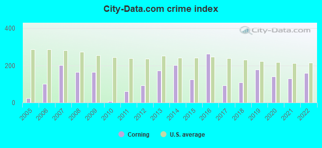
Crime rate in Corning detailed stats: murders, rapes, robberies, assaults, burglaries, thefts, arson
Full-time law enforcement employees in 2021, including police officers: 7 (4 officers - 3 male; 1 female).
| Officers per 1,000 residents here: | 1.34 |
| Arkansas average: | 2.25 |
 Recent articles from our blog. Our writers, many of them Ph.D. graduates or candidates, create easy-to-read articles on a wide variety of topics.

 | Looking for old friend (2 replies) |
| Corning..How Bad Is It? (13 replies) |
| Why do so many people hate Arkansas? (352 replies) |
| pollard arkansas (2 replies) |
| Possibly relocating to Lowell area..any information? (10 replies) |
Latest news from Corning, AR collected exclusively by city-data.com from local newspapers, TV, and radio stations
Ancestries: American (42.9%), English (13.0%), German (8.3%), Irish (5.0%), British (2.5%), Czech (2.5%).
Current Local Time: CST time zone
Incorporated on 08/06/1877
Elevation: 290 feet
Land area: 3.20 square miles.
Population density: 983 people per square mile (low).
67 residents are foreign born (2.0% Latin America).
| This city: | 2.1% |
| Arkansas: | 5.0% |
Median real estate property taxes paid for housing units with mortgages in 2022: $414 (0.4%)
Median real estate property taxes paid for housing units with no mortgage in 2022: $465 (0.5%)
Nearest city with pop. 50,000+: Jonesboro, AR  (40.7 miles , pop. 55,515).
Nearest city with pop. 200,000+: Memphis, TN (95.9 miles , pop. 650,100).
Nearest city with pop. 1,000,000+: Chicago, IL (406.7 miles , pop. 2,896,016).
Nearest cities:
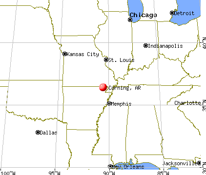
), ), Latitude: 36.41 N, Longitude: 90.59 W
Area code: 870

Corning, Arkansas accommodation & food services, waste management - Economy and Business Data
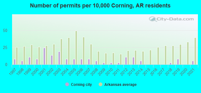
Single-family new house construction building permits:
- 2021: 2 buildings, average cost: $217,500
- 2019: 3 buildings, average cost: $18,300
- 2018: 1 building, cost: $11,000
- 2014: 2 buildings, average cost: $375,000
- 2013: 4 buildings, average cost: $300,000
- 2012: 4 buildings, average cost: $300,000
- 2011: 1 building, cost: $139,700
- 2010: 1 building, cost: $139,700
- 2009: 1 building, cost: $139,700
- 2008: 2 buildings, average cost: $139,700
- 2007: 3 buildings, average cost: $139,700
- 2006: 3 buildings, average cost: $68,200
- 2005: 3 buildings, average cost: $68,200
- 2004: 3 buildings, average cost: $68,200
- 2003: 7 buildings, average cost: $68,200
- 2002: 5 buildings, average cost: $32,600
- 2001: 9 buildings, average cost: $40,300
- 2000: 3 buildings, average cost: $59,700
- 1999: 4 buildings, average cost: $48,800
- 1998: 2 buildings, average cost: $48,800
- 1997: 3 buildings, average cost: $48,800
| Here: | 5.4% |
| Arkansas: | 3.4% |
Population change in the 1990s: +300 (+8.9%).
- Electrical equipment, appliances, components (10.4%)
- Furniture & related product manufacturing (10.2%)
- Health care (9.7%)
- Agriculture, forestry, fishing & hunting (6.4%)
- Construction (4.8%)
- Educational services (4.2%)
- Department & other general merchandise stores (4.1%)
- Furniture & related product manufacturing (13.5%)
- Agriculture, forestry, fishing & hunting (11.3%)
- Construction (8.7%)
- Electrical equipment, appliances, components (5.4%)
- Motor vehicle & parts dealers (4.6%)
- Repair & maintenance (4.0%)
- Transportation equipment (3.5%)

- Health care (17.9%)
- Electrical equipment, appliances, components (15.6%)
- Educational services (7.4%)
- Furniture & related product manufacturing (6.7%)
- Accommodation & food services (6.2%)
- Publishing, motion picture & sound recording industries (5.7%)
- Department & other general merchandise stores (5.3%)
- Other production occupations, including supervisors (8.8%)
- Assemblers and fabricators (6.2%)
- Laborers and material movers, hand (5.8%)
- Other office and administrative support workers, including supervisors (5.2%)
- Metal workers and plastic workers (4.1%)
- Retail sales workers, except cashiers (3.9%)
- Material recording, scheduling, dispatching, and distributing workers (3.8%)
- Other production occupations, including supervisors (9.7%)
- Laborers and material movers, hand (7.0%)
- Vehicle and mobile equipment mechanics, installers, and repairers (5.8%)
- Assemblers and fabricators (5.6%)
- Agricultural workers, including supervisors (5.5%)
- Metal workers and plastic workers (5.0%)
- Driver/sales workers and truck drivers (4.7%)
- Other production occupations, including supervisors (7.9%)
- Other office and administrative support workers, including supervisors (7.7%)
- Assemblers and fabricators (6.7%)
- Retail sales workers, except cashiers (5.3%)
- Waiters and waitresses (5.1%)
- Health technologists and technicians (4.9%)
- Registered nurses (4.7%)
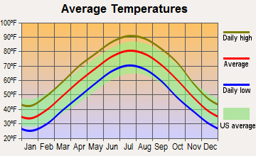
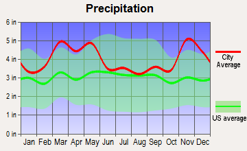
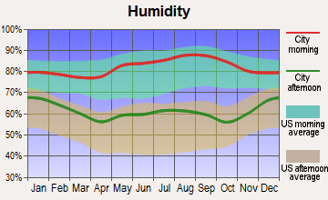
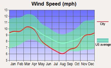
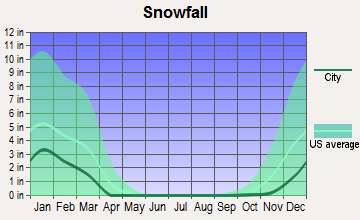
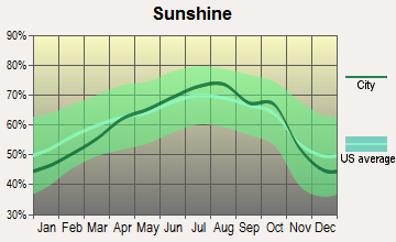
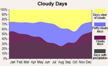
Average climate in Corning, Arkansas
Based on data reported by over 4,000 weather stations
|
|


Tornado activity:
Corning-area historical tornado activity is near Arkansas state average. It is 88% greater than the overall U.S. average.
On 1/21/1999, a category F4 (max. wind speeds 207-260 mph) tornado 9.3 miles away from the Corning city center caused $1 million in damages.
On 4/22/1981, a category F4 tornado 16.2 miles away from the city center killed one person and injured 32 people and caused between $5,000,000 and $50,000,000 in damages.
Earthquake activity:
Corning-area historical earthquake activity is significantly above Arkansas state average. It is 445% greater than the overall U.S. average.On 5/4/1991 at 01:18:54, a magnitude 5.0 (4.4 MB, 4.6 LG, 5.0 LG, Depth: 3.1 mi, Class: Moderate, Intensity: VI - VII) earthquake occurred 43.9 miles away from Corning center
On 3/25/1976 at 00:41:20, a magnitude 5.0 (4.9 MB, 5.0 LG) earthquake occurred 55.4 miles away from the city center
On 9/26/1990 at 13:18:51, a magnitude 5.0 (4.7 MB, 4.8 LG, 5.0 LG, Depth: 7.7 mi) earthquake occurred 78.4 miles away from the city center
On 4/27/1989 at 16:47:49, a magnitude 4.7 (4.6 MB, 4.7 LG, 4.3 LG, Class: Light, Intensity: IV - V) earthquake occurred 53.7 miles away from Corning center
On 4/18/2008 at 09:36:59, a magnitude 5.4 (5.1 MB, 4.8 MS, 5.4 MW, 5.2 MW) earthquake occurred 204.9 miles away from Corning center
On 3/25/1976 at 01:00:11, a magnitude 4.5 (4.1 MB, 4.5 LG) earthquake occurred 55.7 miles away from Corning center
Magnitude types: regional Lg-wave magnitude (LG), body-wave magnitude (MB), surface-wave magnitude (MS), moment magnitude (MW)
Natural disasters:
The number of natural disasters in Clay County (20) is greater than the US average (15).Major Disasters (Presidential) Declared: 16
Emergencies Declared: 2
Causes of natural disasters: Storms: 14, Floods: 13, Tornadoes: 8, Winds: 3, Winter Storms: 2, Hurricane: 1, Ice Storm: 1, Tropical Storm: 1, Other: 1 (Note: some incidents may be assigned to more than one category).

Hospitals and medical centers in Corning:
Airports located in Corning:
- Corning Municipal Airport (4M9) (Runways: 1, Itinerant Ops: 1,000, Local Ops: 32,000, Military Ops: 200)
Colleges/universities with over 2000 students nearest to Corning:
- Three Rivers Community College (about 27 miles; Poplar Bluff, MO; Full-time enrollment: 3,360)
- Arkansas State University-Main Campus (about 40 miles; Jonesboro, AR; FT enrollment: 12,323)
- Dyersburg State Community College (about 72 miles; Dyersburg, TN; FT enrollment: 2,211)
- Southeast Missouri State University (about 86 miles; Cape Girardeau, MO; FT enrollment: 9,678)
- Rhodes College (about 94 miles; Memphis, TN; FT enrollment: 2,052)
- Southwest Tennessee Community College (about 94 miles; Memphis, TN; FT enrollment: 8,043)
- University of Memphis (about 96 miles; Memphis, TN; FT enrollment: 17,427)
Public high school in Corning:
- CORNING HIGH SCHOOL (Location: 602 BOBCAT LANE, Grades: 7-12)
Public elementary/middle schools in Corning:
- CENTRAL ELEMENTARY SCHOOL (Location: 605 W FOURTH ST, Grades: 3-6)
- PARK ELEMENTARY SCHOOL (Location: 510 WYNNE PARK DR, Grades: PK-2)
Points of interest:
Notable locations in Corning: Corning Library (A), Corning City Hall (B), Clay County Courthouse (C), Corning Volunteer Fire Department (D), Clay County Sheriff Department (E), Corning Police Department (F). Display/hide their locations on the map
Shopping Center: Huddle Plaza Shopping Center (1). Display/hide its location on the map
Cemetery: Corning Cemetery (1). Display/hide its location on the map
Park in Corning: Wynn Park (1). Display/hide its location on the map
Hotels: Relaxed Inn (525 North Missouri Avenue), Parkview Motel (1617 West Main Street).
Drinking water stations with addresses in Corning and their reported violations in the past:
CORNING WATERWORKS (Population served: 3,377, Groundwater):Past health violations:Past monitoring violations:
- MCL, Average - Between OCT-2013 and DEC-2013, Contaminant: Combined Radium (-226 and -228). Follow-up actions: St Formal NOV issued (MAR-05-2014), St Public Notif requested (MAR-20-2014)
- MCL, Monthly (TCR) - In MAY-2013, Contaminant: Coliform. Follow-up actions: St Public Notif requested (JUL-12-2013), St Compliance achieved (OCT-31-2013), St Formal NOV issued (MAR-05-2014)
- One minor monitoring violation
| This city: | 2.3 people |
| Arkansas: | 2.5 people |
| This city: | 64.0% |
| Whole state: | 67.6% |
| This city: | 5.2% |
| Whole state: | 5.7% |
Likely homosexual households (counted as self-reported same-sex unmarried-partner households)
- Lesbian couples: 0.1% of all households
- Gay men: 0.0% of all households
Banks with branches in Corning (2011 data):
- First National Bank: Third Street Branch at 502 West Third St., branch established on 1984/06/15; Corning Banking Center at 612 Missouri Avenue, branch established on 1977/04/21. Info updated 2006/11/03: Bank assets: $676.3 mil, Deposits: $536.7 mil, headquarters in Paragould, AR, positive income, Agricultural Specialization, 9 total offices, Holding Company: First Paragould Bankshares, Inc.
- Corning Savings and Loan Association: Corning Savings And Loan Association at 520 West Second Street, branch established on 1974/07/25. Info updated 2011/07/21: Bank assets: $39.9 mil, Deposits: $34.6 mil, local headquarters, positive income, Commercial Lending Specialization, 2 total offices
- Iberiabank: Hwy 62 At Gay St Branch at 309 Missouri Avenue, branch established on 1935/04/01. Info updated 2011/06/08: Bank assets: $11,676.7 mil, Deposits: $9,387.9 mil, headquarters in Lafayette, LA, positive income, Commercial Lending Specialization, 187 total offices, Holding Company: Iberiabank Corporation
For population 15 years and over in Corning:
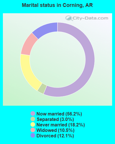
- Never married: 18.2%
- Now married: 56.2%
- Separated: 3.0%
- Widowed: 10.5%
- Divorced: 12.1%
For population 25 years and over in Corning:
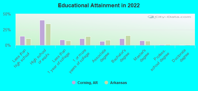
- High school or higher: 83.5%
- Bachelor's degree or higher: 18.6%
- Graduate or professional degree: 8.2%
- Unemployed: 9.7%
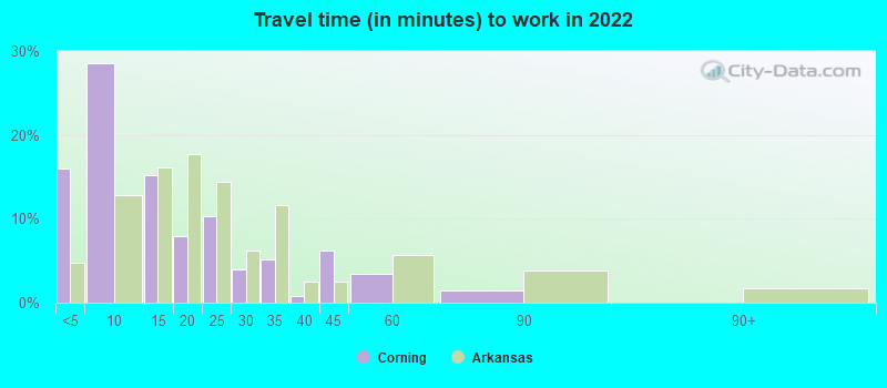
- Mean travel time to work (commute): 19.1 minutes

| Here: | 11.6 |
| Arkansas average: | 11.4 |
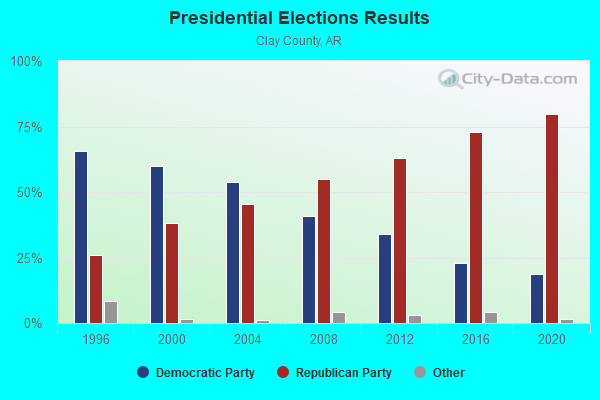
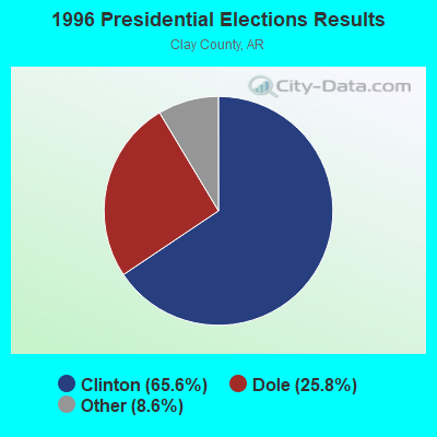
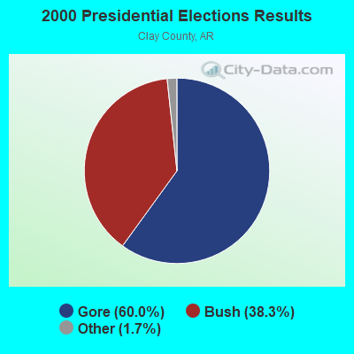
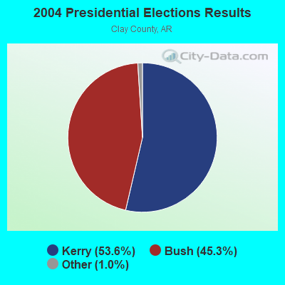
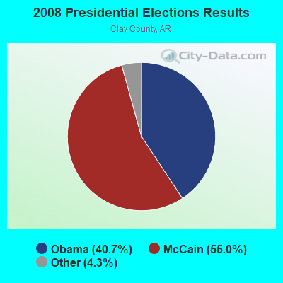
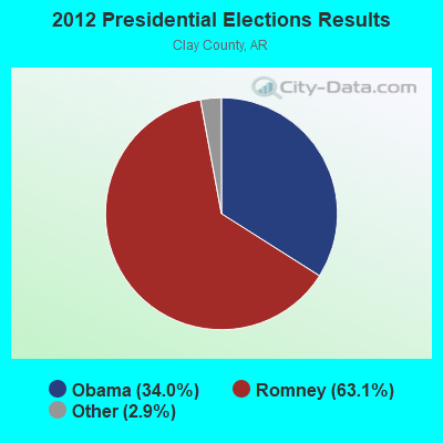
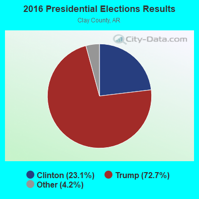
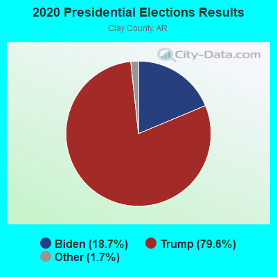
Graphs represent county-level data. Detailed 2008 Election Results
Religion statistics for Corning, AR (based on Clay County data)
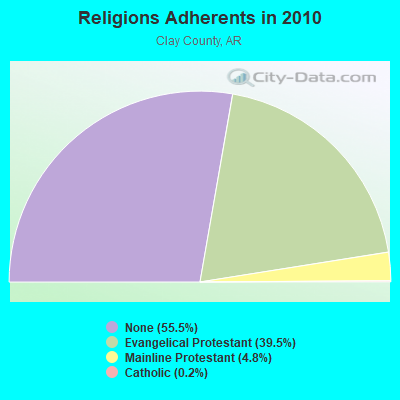
| Religion | Adherents | Congregations |
|---|---|---|
| Evangelical Protestant | 6,355 | 48 |
| Mainline Protestant | 774 | 6 |
| Catholic | 30 | 1 |
| Other | - | 2 |
| None | 8,924 | - |
Food Environment Statistics:
| Clay County: | 2.48 / 10,000 pop. |
| Arkansas: | 2.02 / 10,000 pop. |
| Clay County: | 0.62 / 10,000 pop. |
| Arkansas: | 0.59 / 10,000 pop. |
| This county: | 3.73 / 10,000 pop. |
| Arkansas: | 4.94 / 10,000 pop. |
| Clay County: | 4.35 / 10,000 pop. |
| Arkansas: | 6.66 / 10,000 pop. |
| This county: | 10.7% |
| State: | 9.8% |
| Here: | 30.0% |
| Arkansas: | 29.1% |
| Clay County: | 14.0% |
| Arkansas: | 13.6% |
Health and Nutrition:
| This city: | 50.6% |
| Arkansas: | 48.2% |
| Corning: | 46.9% |
| Arkansas: | 44.2% |
| Corning: | 28.6 |
| State: | 28.9 |
| Corning: | 22.6% |
| Arkansas: | 21.6% |
| This city: | 5.9% |
| State: | 11.3% |
| Here: | 6.8 |
| State: | 6.8 |
| Here: | 32.0% |
| Arkansas: | 34.0% |
| Corning: | 58.2% |
| Arkansas: | 54.4% |
| Corning: | 75.8% |
| State: | 78.0% |
More about Health and Nutrition of Corning, AR Residents
| Local government employment and payroll (March 2022) | |||||
| Function | Full-time employees | Monthly full-time payroll | Average yearly full-time wage | Part-time employees | Monthly part-time payroll |
|---|---|---|---|---|---|
| Police Protection - Officers | 8 | $29,630 | $44,445 | 4 | $2,398 |
| Water Supply | 3 | $7,521 | $30,084 | 0 | $0 |
| Streets and Highways | 3 | $9,528 | $38,112 | 0 | $0 |
| Other and Unallocable | 1 | $2,035 | $24,420 | 0 | $0 |
| Parks and Recreation | 1 | $4,686 | $56,232 | 5 | $7,836 |
| Solid Waste Management | 1 | $1,523 | $18,276 | 0 | $0 |
| Other Government Administration | 1 | $6,077 | $72,924 | 1 | $296 |
| Judicial and Legal | 1 | $2,137 | $25,644 | 1 | $533 |
| Sewerage | 1 | $3,526 | $42,312 | 0 | $0 |
| Firefighters | 0 | $0 | 1 | $451 | |
| Totals for Government | 20 | $66,663 | $39,998 | 12 | $11,514 |
Corning government finances - Expenditure in 2017 (per resident):
- Construction - Air Transportation: $688,000 ($218.76)
- Current Operations - Police Protection: $598,000 ($190.14)
Parks and Recreation: $427,000 ($135.77)
Solid Waste Management: $362,000 ($115.10)
Water Utilities: $338,000 ($107.47)
Regular Highways: $258,000 ($82.03)
General - Other: $167,000 ($53.10)
Financial Administration: $151,000 ($48.01)
Central Staff Services: $139,000 ($44.20)
Sewerage: $82,000 ($26.07)
Air Transportation: $60,000 ($19.08)
Local Fire Protection: $50,000 ($15.90)
Health - Other: $33,000 ($10.49)
Judicial and Legal Services: $31,000 ($9.86)
Miscellaneous Commercial Activities - Other: $17,000 ($5.41)
Libraries: $7,000 ($2.23)
- General - Interest on Debt: $216,000 ($68.68)
- Other Capital Outlay - Parks and Recreation: $6,000 ($1.91)
- Total Salaries and Wages: $987,000 ($313.83)
Corning government finances - Revenue in 2017 (per resident):
- Charges - Solid Waste Management: $233,000 ($74.09)
Sewerage: $214,000 ($68.04)
Parks and Recreation: $126,000 ($40.06)
Air Transportation: $63,000 ($20.03)
Miscellaneous Commercial Activities: $10,000 ($3.18)
- Federal Intergovernmental - Air Transportation: $688,000 ($218.76)
- Local Intergovernmental - General Local Government Support: $139,000 ($44.20)
- Miscellaneous - General Revenue - Other: $106,000 ($33.70)
Rents: $96,000 ($30.52)
Fines and Forfeits: $93,000 ($29.57)
Interest Earnings: $19,000 ($6.04)
- Revenue - Water Utilities: $383,000 ($121.78)
- State Intergovernmental - Highways: $163,000 ($51.83)
General Local Government Support: $78,000 ($24.80)
Other: $47,000 ($14.94)
- Tax - General Sales and Gross Receipts: $1,130,000 ($359.30)
Public Utilities Sales: $328,000 ($104.29)
Property: $223,000 ($70.91)
Occupation and Business License - Other: $11,000 ($3.50)
Other License: $2,000 ($0.64)
Corning government finances - Debt in 2017 (per resident):
- Long Term Debt - Beginning Outstanding - Unspecified Public Purpose: $5,314,000 ($1689.67)
Outstanding Unspecified Public Purpose: $5,239,000 ($1665.82)
Retired Unspecified Public Purpose: $75,000 ($23.85)
Corning government finances - Cash and Securities in 2017 (per resident):
- Other Funds - Cash and Securities: $1,283,000 ($407.95)
| Businesses in Corning, AR | ||||
| Name | Count | Name | Count | |
|---|---|---|---|---|
| AT&T | 1 | McDonald's | 1 | |
| Ace Hardware | 1 | Pizza Hut | 1 | |
| FedEx | 1 | SONIC Drive-In | 1 | |
| Ford | 1 | Subway | 1 | |
| H&R Block | 1 | Walmart | 1 | |
| Jones New York | 1 | |||
Strongest AM radio stations in Corning:
- KCCB (1260 AM; 1 kW; CORNING, AR; Owner: SHIELDS-ADKINS BROADCASTING, INC.)
- KOTC (830 AM; daytime; 10 kW; KENNETT, MO; Owner: EAGLE BLUFF ENTERPRISES)
- KWOC (930 AM; 5 kW; POPLAR BLUFF, MO; Owner: ZIMMER RADIO OF MID-MISSOURI, INC)
- WCRV (640 AM; 50 kW; COLLIERVILLE, TN; Owner: BOTT BROADCASTING COMPANY/TENNESSEE)
- WDIA (1070 AM; 50 kW; MEMPHIS, TN; Owner: CLEAR CHANNEL BROADCASTING LICENSES, INC.)
- WGSF (1030 AM; 50 kW; MEMPHIS, TN; Owner: FLINN BROADCASTING CORPORATION)
- KDFN (1500 AM; daytime; 2 kW; DONIPHAN, MO; Owner: EAGLE BLUFF ENTERPRISES)
- WMQM (1600 AM; 50 kW; LAKELAND, TN; Owner: WMQM, INC.)
- KGHT (880 AM; 50 kW; SHERIDAN, AR; Owner: METROPOLITAN RADIO GROUP, INC.)
- KLCN (910 AM; 5 kW; BLYTHEVILLE, AR; Owner: SUDBURY SERVICES, INC.)
- KAAY (1090 AM; 50 kW; LITTLE ROCK, AR; Owner: CITADEL BROADCASTING COMPANY)
- WJCE (680 AM; 10 kW; MEMPHIS, TN; Owner: ENTERCOM MEMPHIS LICENSE, LLC)
- KXEN (1010 AM; 50 kW; FESTUS-ST. LOUIS, MO; Owner: BDJ RADIO ENTERPRISES, LLC)
Strongest FM radio stations in Corning:
- KBKG (93.5 FM; CORNING, AR; Owner: SHIELDS-ADKINS BROADCASTING, INC.)
- WJZN (98.9 FM; MUNFORD, TN; Owner: MEMPHIS III LIMITED PARTNERSHIP)
- KOEA (97.5 FM; DONIPHAN, MO; Owner: EAGLE BLUFF ENTERPRISES)
- KKLR-FM (94.5 FM; POPLAR BLUFF, MO; Owner: ZIMMER RADIO OF MID-MISSOURI, INC)
- KIYS (101.9 FM; JONESBORO, AR; Owner: ,CAPSTAR TX LIMITED PARTNERSHIP)
- KASU (91.9 FM; JONESBORO, AR; Owner: ARKANSAS STATE UNIVERSITY)
- KFIN (107.9 FM; JONESBORO, AR; Owner: CAPSTAR TX LIMITED PARTNERSHIP)
- KDRS-FM (107.1 FM; PARAGOULD, AR; Owner: MOR MEDIA, INC.)
- KOKS (89.5 FM; POPLAR BLUFF, MO; Owner: CALVARY ED. B/CASTING NETWORK)
- KPPL (92.5 FM; POPLAR BLUFF, MO; Owner: GEORGE S. FLINN, JR.)
- K211BX (90.1 FM; POCAHONTAS, AR; Owner: AMERICAN FAMILY ASSOCIATION)
- KAHR (96.7 FM; POPLAR BLUFF, MO; Owner: EAGLE BLUFF ENTERPRISES)
- K201DK (88.1 FM; PIGGOTT, AR; Owner: AMERICAN FAMILY RADIO)
TV broadcast stations around Corning:
- KAIT (Channel 8; JONESBORO, AR; Owner: LIBCO, INC.)
- K46EM (Channel 46; BATESVILLE, AR; Owner: MS COMMUNICATIONS, LLC)
- KTEJ (Channel 19; JONESBORO, AR; Owner: ARKANSAS EDUCATIONAL TELEVISION COMMISSION)
- K39CP (Channel 39; POPLAR BLUFF, MO; Owner: TRINITY BROADCASTING NETWORK)
- KPOB-TV (Channel 15; POPLAR BLUFF, MO; Owner: WSIL-TV, INC.)
- K26EC (Channel 26; POPLAR BLUFF, MO; Owner: VINCIE PRITCHARD)
- K28ED (Channel 28; POPLAR BLUFF, MO; Owner: JAMES W. PRINGLE)
- K31EB (Channel 31; POPLAR BLUFF, MO; Owner: LYN GUIN)
- K35EP (Channel 35; POPLAR BLUFF, MO; Owner: JEFFREY NAROD)
- K56FP (Channel 56; POPLAR BLUFF, MO; Owner: LLOYD JOHNSON)
- K59FE (Channel 59; POPLAR BLUFF, MO; Owner: MARIE JOHNSON)
- K61FY (Channel 61; POPLAR BLUFF, MO; Owner: MARIE JOHNSON)
- K68FL (Channel 68; POPLAR BLUFF, MO; Owner: ANA WINKLER)
- National Bridge Inventory (NBI) Statistics
- 19Number of bridges
- 167ft / 50.5mTotal length
- $3,915,000Total costs
- 43,076Total average daily traffic
- 8,531Total average daily truck traffic
- 43,493Total future (year 2007) average daily traffic
- New bridges - historical statistics
- 31920-1929
- 11930-1939
- 31950-1959
- 31970-1979
- 11990-1999
- 42000-2009
- 42010-2019
FCC Registered Cell Phone Towers:
3 (See the full list of FCC Registered Cell Phone Towers in Corning)FCC Registered Antenna Towers:
27 (See the full list of FCC Registered Antenna Towers)FCC Registered Broadcast Land Mobile Towers:
6- Us Hwy 67 At North City Limits (Lat: 36.418111 Lon: -90.589000), Call Sign: KHI36, Licensee ID: L00007580,
Assigned Frequencies: 156.105 MHz, Grant Date: 08/03/2002, Expiration Date: 10/27/2012, Cancellation Date: 08/05/2008, Registrant: State Of Arkansas, Box 2261, Little Rock, AR 72203
- Uprr 190 Ft S Of Us 62 & W First St (Lat: 36.407833 Lon: -90.580944), Type: Tower, Structure height: 37 m, Overall height: 43 m, Call Sign: WPPZ997,
Assigned Frequencies: 935.887 MHz, 935.937 MHz, 935.987 MHz, 936.887 MHz, 936.937 MHz, 936.987 MHz, Grant Date: 04/12/2000, Expiration Date: 04/12/2005, Cancellation Date: 02/10/2005, Certifier: Robert Vandeberg, Registrant: B & R Consultants Inc, 13360 S Cliffside Dr, Mulino, OR 97042-9636, Fax: (503) 632-3142
- Master Meter Vault E On Hwy 62 (Lat: 36.403944 Lon: -90.559556), Type: Upole, Structure height: 9 m, Call Sign: WPOE454,
Assigned Frequencies: 173.287 MHz, Grant Date: 08/08/2014, Expiration Date: 08/17/2024, Certifier: Bobby L Brown, Registrant: Instrument And Supply, 141 Technic Circle, Hot Springs, AR 71901, Phone: (501) 262-3282
- Corning Municipal Airport (Lat: 36.407833 Lon: -90.650111), Call Sign: KNAI663,
Assigned Frequencies: 151.595 MHz, Grant Date: 05/14/1997, Expiration Date: 07/07/2002, Cancellation Date: 11/10/2002, Registrant: Mtm Aircraft Inc, Corning, AR 72422, Phone: (501) 857-3289
- Corning Municipal Airport (Lat: 36.410778 Lon: -90.649611), Type: Tower, Structure height: 4.6 m, Overall height: 4.9 m, Call Sign: WQIH494,
Assigned Frequencies: 453.412 MHz, Grant Date: 01/03/2018, Expiration Date: 02/12/2028, Certifier: Mark D Rockwell, Registrant: Mc Clelland Consulting Engineers, Inc., P. O. Box 34087, Little Rock, AR 72203-4087, Phone: (501) 371-0272, Fax: (501) 371-9932, Email:
- Airport Rd 980 (Lat: 36.405194 Lon: -90.649694), Type: Pole, Structure height: 6 m, Call Sign: WQXR884,
Assigned Frequencies: 153.155 MHz, Grant Date: 05/20/2016, Expiration Date: 05/20/2026, Certifier: Matt D Woolard, Registrant: Business Radio Licensing, 30251 Golden Lantern Ste E #501, Laguna Niguel, CA 92677, Phone: (949) 348-8510, Fax: (949) 348-8514, Email:
FCC Registered Microwave Towers:
5- STATION, Mp Depot West First & Vine St (Lat: 36.407833 Lon: -90.580944), Overall height: 41.5 m, Call Sign: WNTN847,
Assigned Frequencies: 928.343 MHz, 952.343 MHz, Grant Date: 01/20/2018, Expiration Date: 02/13/2028, Registrant: Prokarma, 222 So 15th St., Suite 505n, Omaha, NE 68102, Phone: (402) 522-5068, Fax: (402) 346-6676, Email:
- CORNING NORTH, 851 County Highway 148 (Lat: 36.452583 Lon: -90.545972), Type: Ltower, Structure height: 76.2 m, Overall height: 78.9 m, Call Sign: WQWI711,
Assigned Frequencies: 11485.0 MHz, 11565.0 MHz, Grant Date: 09/02/2015, Expiration Date: 09/02/2025, Certifier: Gregory M Romano, Registrant: Verizon, 5055 Northpointe Pkwy, Alpharetta, GA 30022, Phone: (770) 797-1070, Email:
- CORNING, 211 Pyburn St Off Lee St, East Of Sr #67 (Lat: 36.420583 Lon: -90.581889), Type: Gtower, Structure height: 97.5 m, Overall height: 98.4 m, Call Sign: WQWI712,
Assigned Frequencies: 10995.0 MHz, 11075.0 MHz, Grant Date: 09/02/2015, Expiration Date: 09/02/2025, Certifier: Gregory M Romano, Registrant: Verizon, 5055 Northpointe Pkwy, Alpharetta, GA 30022, Phone: (770) 797-1070, Email:
- CLAYARAA, 851 County Highway 148 (Lat: 36.452583 Lon: -90.545972), Type: Ltower, Structure height: 76.2 m, Overall height: 78.9 m, Call Sign: WRNY319, Licensee ID: L02347278,
Assigned Frequencies: 11325.0 MHz, 11325.0 MHz, 11325.0 MHz, 11325.0 MHz, 11325.0 MHz, 11325.0 MHz, 11325.0 MHz, 11325.0 MHz, 11325.0 MHz, 11325.0 MHz, Grant Date: 09/08/2021, Expiration Date: 09/08/2031, Certifier: Dave Mills, Registrant: Wisper Isp, LLC, 9711 Fuesser Road, Mascoutah, IL 62258, Phone: (618) 206-4190, Email:
- AR01942A, 703 Lee Drive (Lat: 36.420583 Lon: -90.581889), Type: Gtower, Structure height: 95.4 m, Call Sign: WRUM875,
Assigned Frequencies: 6330.66 MHz, 6330.66 MHz, 6330.66 MHz, 6330.66 MHz, 6330.66 MHz, 6330.66 MHz, 6330.66 MHz, 6330.66 MHz, 6330.66 MHz, 6330.66 MHz, 6330.66 MHz, 6330.66 MHz, Grant Date: 09/13/2022, Expiration Date: 09/13/2032, Certifier: Jenny Knopf, Registrant: T-Mobile Usa, Inc., 12920 Se 38th Street, Bellevue, WA 98006, Phone: (425) 383-8401, Fax: (425) 383-4040, Email:
FCC Registered Maritime Coast & Aviation Ground Towers:
2- Corning Municipal Airport (Lat: 36.404778 Lon: -90.648444), Type: Building, Overall height: 8 m, Call Sign: WLP6,
Assigned Frequencies: 123.000 MHz, Grant Date: 06/01/1998, Expiration Date: 06/10/2003, Cancellation Date: 09/07/2003, Registrant: City Of Corning, Corning, AR 72422
- Corning Municipal Airport (Lat: 36.408056 Lon: -90.649722), Type: Bant, Structure height: 4.6 m, Overall height: 4.9 m, Call Sign: WQJE900,
Assigned Frequencies: 118.325 MHz, Grant Date: 09/06/2018, Expiration Date: 08/15/2028, Certifier: Matthew R Vinyard, Registrant: Corning Municipal Airport, 62 Airport Hwy 980, Corning, AR 72422, Phone: (870) 323-0304, Fax: (501) 371-9932, Email:
FCC Registered Amateur Radio Licenses:
10 (See the full list of FCC Registered Amateur Radio Licenses in Corning)FAA Registered Aircraft Manufacturers and Dealers:
7 (See the full list of FAA Registered Manufacturers and Dealers in Corning)FAA Registered Aircraft:
20 (See the full list of FAA Registered Aircraft)2004 - 2018 National Fire Incident Reporting System (NFIRS) incidents
- Fire incident types reported to NFIRS in Corning, AR
- 14344.5%Structure Fires
- 13140.8%Outside Fires
- 4614.3%Mobile Property/Vehicle Fires
- 10.3%Other
 Based on the data from the years 2004 - 2018 the average number of fire incidents per year is 21. The highest number of reported fire incidents - 37 took place in 2007, and the least - 0 in 2006. The data has a growing trend.
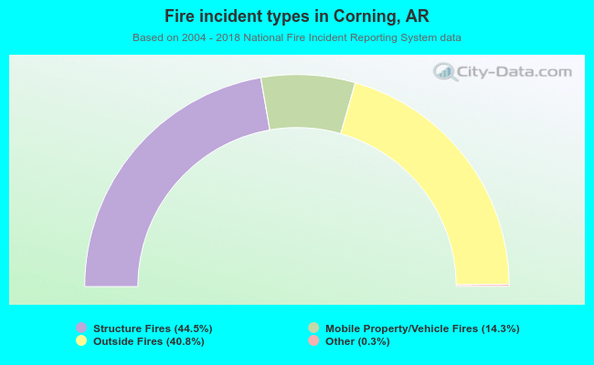 When looking into fire subcategories, the most incidents belonged to: Structure Fires (44.5%), and Outside Fires (40.8%).
| Most common first names in Corning, AR among deceased individuals | ||
| Name | Count | Lived (average) |
|---|---|---|
| James | 81 | 73.7 years |
| William | 65 | 74.4 years |
| John | 58 | 74.2 years |
| Mary | 52 | 78.7 years |
| Charles | 41 | 73.3 years |
| George | 34 | 77.7 years |
| Robert | 31 | 74.4 years |
| Myrtle | 23 | 81.7 years |
| Henry | 22 | 78.0 years |
| Earl | 21 | 71.1 years |
| Most common last names in Corning, AR among deceased individuals | ||
| Last name | Count | Lived (average) |
|---|---|---|
| Smith | 51 | 77.3 years |
| Williams | 24 | 76.1 years |
| Miller | 23 | 74.4 years |
| Brown | 21 | 79.0 years |
| Moore | 19 | 77.8 years |
| Johnson | 19 | 80.3 years |
| Taylor | 18 | 72.4 years |
| White | 18 | 82.4 years |
| Jones | 17 | 69.5 years |
| Jackson | 17 | 79.0 years |
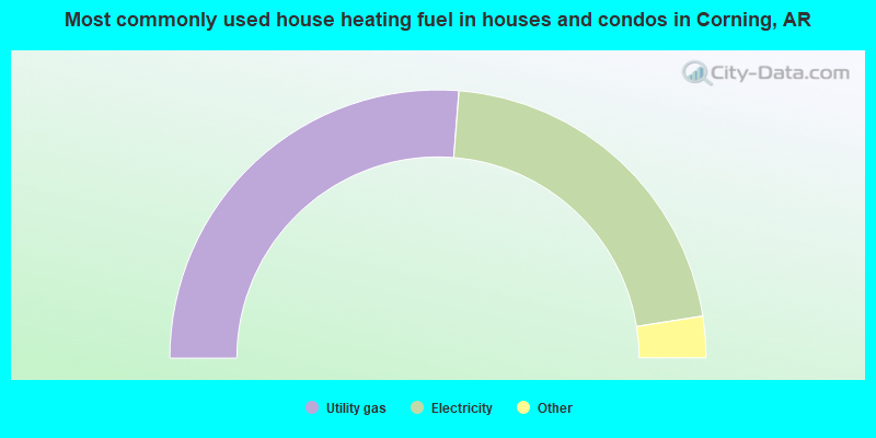
- 52.5%Utility gas
- 42.5%Electricity
- 2.6%Bottled, tank, or LP gas
- 1.4%No fuel used
- 1.0%Wood
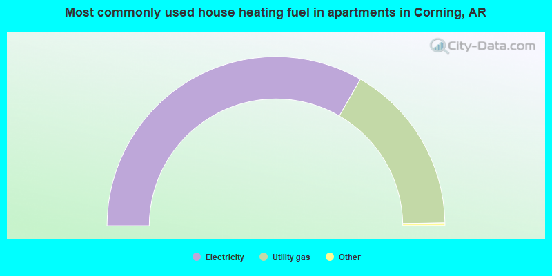
- 67.0%Electricity
- 33.0%Utility gas
Corning compared to Arkansas state average:
- Median house value below state average.
- Black race population percentage significantly below state average.
- Hispanic race population percentage significantly below state average.
- Foreign-born population percentage significantly below state average.
- Length of stay since moving in significantly above state average.