Cottonwood, Utah
Submit your own pictures of this place and show them to the world
- OSM Map
- General Map
- Google Map
- MSN Map

| Males: 2,793 | |
| Females: 2,439 |
| Median resident age: | 36.3 years |
| Utah median age: | 27.1 years |
Zip code: 84121
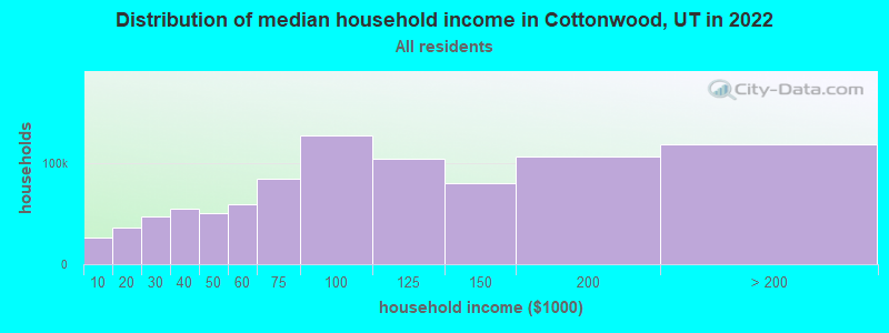
| Cottonwood: | $194,226 |
| UT: | $89,168 |
Estimated per capita income in 2022: $89,949 (it was $42,982 in 2000)
Cottonwood CCD income, earnings, and wages data
Estimated median house or condo value in 2022: over $1,000,000 (it was $336,500 in 2000)
| Cottonwood: | over $1,000,000 |
| UT: | $499,500 |
Mean prices in 2022: all housing units: $599,446; detached houses: $646,664; townhouses or other attached units: $438,665; in 2-unit structures: $468,515; in 3-to-4-unit structures: $333,219; in 5-or-more-unit structures: $403,097; mobile homes: $113,165
Detailed information about poverty and poor residents in Cottonwood, UT
Compare current foreclosures near Cottonwood, UT:
| Photo | Address | Area | Beds / Baths | Price | Details |
|---|---|---|---|---|---|

|
#1
S Holladay Cir
Salt Lake City, UT 84117
|
2,440 sq. feet
|
2 baths 4 beds |
$799,900
|
show details |

|
#2
E Downington Ave
Salt Lake City, UT 84108
|
2,580 sq. feet
|
2 baths 1 beds |
$949,900
|
show details |

|
#3
W Alta View Way
Sandy, UT 84070
|
1,440 sq. feet
|
2 baths 3 beds |
show details | |

|
#4
W 5780 S
Salt Lake City, UT 84129
|
1,100 sq. feet
|
1 baths 1 beds |
show details | |

|
#5
S Solano Cir
Salt Lake City, UT 84120
|
1,009 sq. feet
|
2 baths 5 beds |
show details | |

|
#6
S Cascade Way
Salt Lake City, UT 84109
|
1,185 sq. feet
|
1 baths 5 beds |
show details | |

|
#7
S Interlochin Ln
West Jordan, UT 84084
|
2,054 sq. feet
|
2 baths 3 beds |
show details | |

|
#8
W 3800 S
Salt Lake City, UT 84119
|
2,050 sq. feet
|
2 baths 3 beds |
show details | |

|
#9
S 4340 W
Salt Lake City, UT 84118
|
1,176 sq. feet
|
2 baths 3 beds |
show details | |

|
#10
Mankato St
Herriman, UT 84096
|
1,468 sq. feet
|
2 baths 3 beds |
show details |
| Photo | Address | Area | Beds / Baths | Price | Details |
|---|---|---|---|---|---|

|
#11
E Wilson Ave
Salt Lake City, UT 84105
|
950 sq. feet
|
1 baths 3 beds |
show details | |

|
#12
W 300 S
Salt Lake City, UT 84104
|
1,313 sq. feet
|
1 baths 3 beds |
show details | |

|
#13
W Aspen Springs Dr
Herriman, UT 84096
|
1,334 sq. feet
|
2 baths 2 beds |
show details | |

|
#14
Ashley Ridge Rd
Sandy, UT 84092
|
2,661 sq. feet
|
2 baths 6 beds |
show details | |

|
#15
S Meadowlark Ln
West Jordan, UT 84088
|
1,748 sq. feet
|
2 baths 3 beds |
show details | |

|
#16
W Heath Ave
Salt Lake City, UT 84118
|
979 sq. feet
|
1 baths 5 beds |
show details | |

|
#17
W 6785 S
West Jordan, UT 84084
|
1,516 sq. feet
|
3 baths 4 beds |
show details | |

|
#18
W 10180 N
American Fork, UT 84003
|
2,478 sq. feet
|
2 baths 3 beds |
show details | |

|
#19
S 1175 W Apt 109
Salt Lake City, UT 84123
|
1,120 sq. feet
|
2 baths 3 beds |
show details | |

|
#20
Canary Bird Cv
Herriman, UT 84096
|
1,276 sq. feet
|
2 baths 3 beds |
show details |
| Photo | Address | Area | Beds / Baths | Price | Details |
|---|---|---|---|---|---|

|
#21
S 2330 W
South Jordan, UT 84095
|
3,809 sq. feet
|
2 baths 4 beds |
show details | |

|
#22
W Van St
West Jordan, UT 84088
|
1,466 sq. feet
|
2 baths 3 beds |
show details | |

|
#23
W 12120 S
Riverton, UT 84065
|
1,572 sq. feet
|
2 baths 3 beds |
show details | |

|
#24
E Driggs Ave
Salt Lake City, UT 84106
|
1,230 sq. feet
|
1 baths 3 beds |
show details | |

|
#25
E Louise Ave
Salt Lake City, UT 84115
|
1,280 sq. feet
|
2 baths 4 beds |
show details | |

|
#26
W 400 N
Salt Lake City, UT 84116
|
1,200 sq. feet
|
1 baths 2 beds |
show details | |

|
#27
S 600 E
Salt Lake City, UT 84106
|
2,500 sq. feet
|
5 baths 6 beds |
show details | |

|
#28
S Margray Dr
Salt Lake City, UT 84129
|
1,776 sq. feet
|
2 baths 4 beds |
show details | |

|
#29
S 2400 W
West Jordan, UT 84084
|
1,894 sq. feet
|
2 baths 4 beds |
show details | |

|
#30
Flintlock Way
Herriman, UT 84096
|
1,683 sq. feet
|
2 baths 3 beds |
show details |
| Photo | Address | Area | Beds / Baths | Price | Details |
|---|---|---|---|---|---|

|
#31
E Vidas Ave
Salt Lake City, UT 84115
|
1,025 sq. feet
|
1 baths 3 beds |
show details | |

|
#32
S 2345 W
West Jordan, UT 84084
|
1,600 sq. feet
|
2 baths 3 beds |
show details | |

|
#33
W Rustic Roads Dr
South Jordan, UT 84095
|
2,404 sq. feet
|
3 baths 6 beds |
show details | |

|
#34
W 6200 S
Salt Lake City, UT 84129
|
2,000 sq. feet
|
2 baths 5 beds |
show details | |

|
#35
N 980 E
American Fork, UT 84003
|
1,616 sq. feet
|
2 baths 4 beds |
show details | |

|
#36
S Summerwood St
Salt Lake City, UT 84123
|
1,277 sq. feet
|
1 baths 3 beds |
show details | |

|
#37
W 7095 S
West Jordan, UT 84084
|
2,000 sq. feet
|
3 baths 3 beds |
show details | |

|
#38
W 10950 S
South Jordan, UT 84095
|
2,510 sq. feet
|
2 baths 3 beds |
show details | |

|
#39
S Mcginnis Ln
West Jordan, UT 84081
|
2,264 sq. feet
|
3 baths 4 beds |
show details | |

|
#40
S 600 E
Pleasant Grove, UT 84062
|
816 sq. feet
|
1 baths 2 beds |
show details |
| Photo | Address | Area | Beds / Baths | Price | Details |
|---|---|---|---|---|---|

|
#41
S Thrush Hill Dr
West Jordan, UT 84081
|
2,401 sq. feet
|
3 baths 5 beds |
show details | |

|
#42
W Brookway Dr
Salt Lake City, UT 84119
|
1,234 sq. feet
|
2 baths 3 beds |
show details | |

|
#43
S Silver Trace Cir
Herriman, UT 84096
|
2,325 sq. feet
|
3 baths 4 beds |
show details | |

|
#44
S 1975 W
West Jordan, UT 84084
|
1,150 sq. feet
|
1 baths 3 beds |
show details | |

|
#45
S West Temple
Salt Lake City, UT 84115
|
868 sq. feet
|
1 baths 2 beds |
show details | |

|
#46
E 7th Ave
Salt Lake City, UT 84103
|
3,307 sq. feet
|
3 baths 5 beds |
show details | |

|
#47
S 2200 W
South Jordan, UT 84095
|
2,051 sq. feet
|
1 baths 2 beds |
show details | |

|
#48
S 5170 W
West Jordan, UT 84081
|
1,717 sq. feet
|
3 baths 4 beds |
show details | |

|
#49
N 2300 W
Lehi, UT 84043
|
1,536 sq. feet
|
2 baths 3 beds |
show details | |

|
Check over 1 million property listings on Foreclosure.com!
|
browse all offers | |||

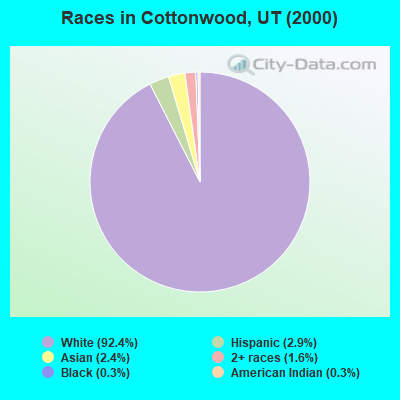
- 4,34592.4%White alone
- 1352.9%Hispanic
- 1132.4%Asian alone
- 741.6%Two or more races
- 160.3%Black alone
- 160.3%American Indian alone
- 40.09%Native Hawaiian and Other
Pacific Islander alone
Races in Cottonwood detailed stats: ancestries, foreign born residents, place of birth
 Recent articles from our blog. Our writers, many of them Ph.D. graduates or candidates, create easy-to-read articles on a wide variety of topics.
Current Local Time: MST time zone
Land area: 87.4 square miles.
Population density: 60 people per square mile (very low).

| Cottonwood CCD: | 0.7% ($2,472) |
| Utah: | 0.7% ($956) |
Nearest city with pop. 50,000+: Sandy, UT  (7.4 miles , pop. 88,418).
Nearest city with pop. 200,000+: Northeast Jefferson, CO (354.2 miles , pop. 450,166).
Nearest city with pop. 1,000,000+: Phoenix, AZ (488.5 miles , pop. 1,321,045).
Nearest cities:
), ), ), )Latitude: 40.59 N, Longitude: 111.72 W
Area code commonly used in this area: 801

Cottonwood tourist attractions:
| Here: | 2.5% |
| Utah: | 2.5% |
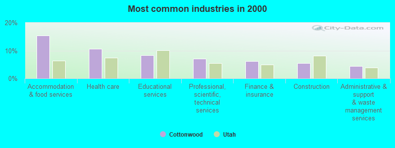
- Accommodation & food services (15.3%)
- Health care (10.6%)
- Educational services (8.3%)
- Professional, scientific, technical services (7.0%)
- Finance & insurance (6.1%)
- Construction (5.5%)
- Administrative & support & waste management services (4.4%)
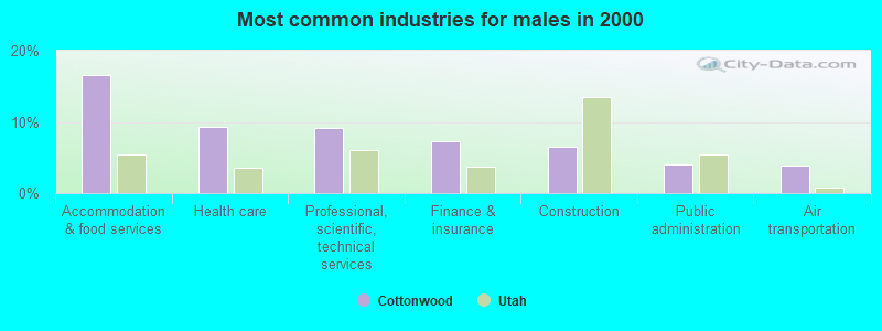
- Accommodation & food services (16.6%)
- Health care (9.4%)
- Professional, scientific, technical services (9.1%)
- Finance & insurance (7.3%)
- Construction (6.6%)
- Public administration (4.0%)
- Air transportation (3.8%)
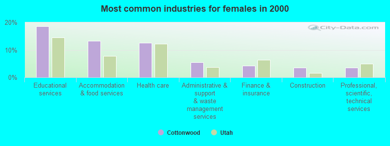
- Educational services (18.5%)
- Accommodation & food services (13.2%)
- Health care (12.6%)
- Administrative & support & waste management services (5.4%)
- Finance & insurance (4.2%)
- Construction (3.6%)
- Professional, scientific, technical services (3.6%)
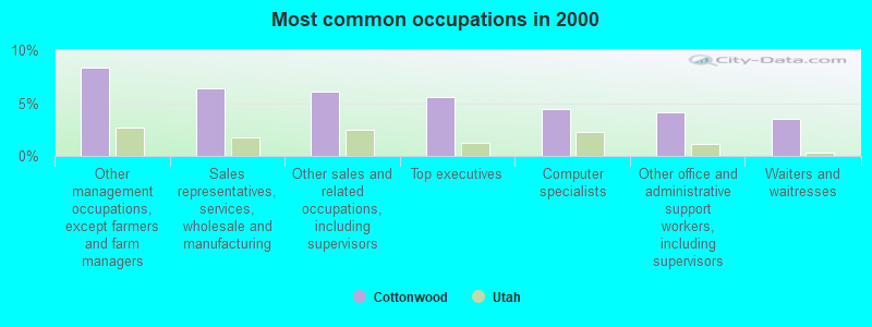
- Other management occupations, except farmers and farm managers (8.4%)
- Sales representatives, services, wholesale and manufacturing (6.4%)
- Other sales and related occupations, including supervisors (6.1%)
- Top executives (5.5%)
- Computer specialists (4.4%)
- Other office and administrative support workers, including supervisors (4.1%)
- Waiters and waitresses (3.5%)
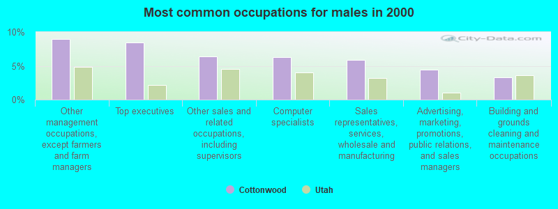
- Other management occupations, except farmers and farm managers (9.0%)
- Top executives (8.5%)
- Other sales and related occupations, including supervisors (6.4%)
- Computer specialists (6.3%)
- Sales representatives, services, wholesale and manufacturing (5.9%)
- Advertising, marketing, promotions, public relations, and sales managers (4.4%)
- Building and grounds cleaning and maintenance occupations (3.3%)
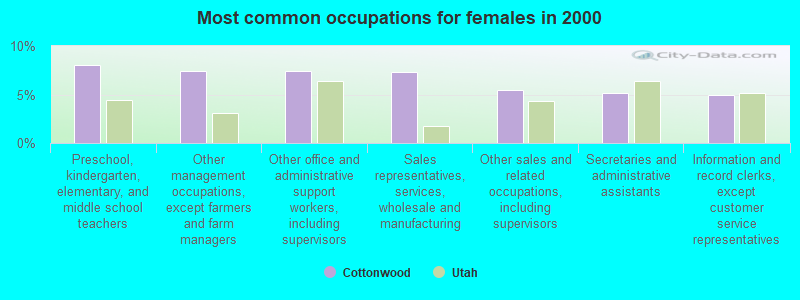
- Preschool, kindergarten, elementary, and middle school teachers (8.0%)
- Other management occupations, except farmers and farm managers (7.4%)
- Other office and administrative support workers, including supervisors (7.4%)
- Sales representatives, services, wholesale and manufacturing (7.3%)
- Other sales and related occupations, including supervisors (5.5%)
- Secretaries and administrative assistants (5.2%)
- Information and record clerks, except customer service representatives (5.0%)
Average climate in Cottonwood, Utah
Based on data reported by over 4,000 weather stations


(lower is better)
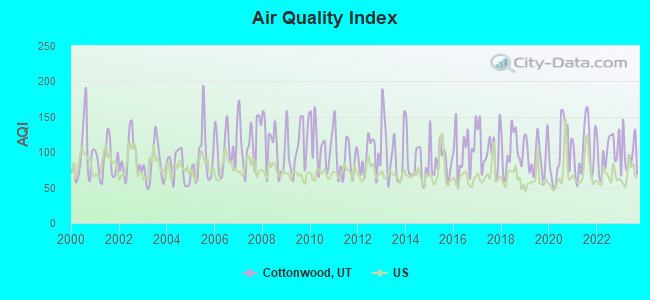
Air Quality Index (AQI) level in 2023 was 95.8. This is worse than average.
| City: | 95.8 |
| U.S.: | 72.6 |
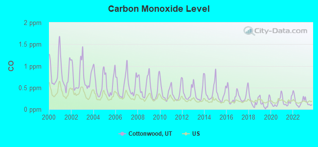
Carbon Monoxide (CO) [ppm] level in 2023 was 0.151. This is significantly better than average. Closest monitor was 8.0 miles away from the city center.
| City: | 0.151 |
| U.S.: | 0.251 |
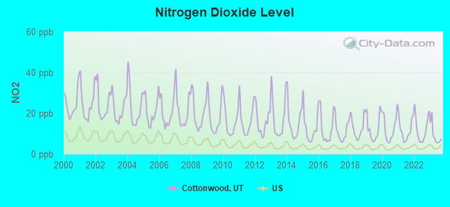
Nitrogen Dioxide (NO2) [ppb] level in 2023 was 9.24. This is significantly worse than average. Closest monitor was 8.0 miles away from the city center.
| City: | 9.24 |
| U.S.: | 5.11 |
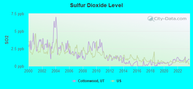
Sulfur Dioxide (SO2) [ppb] level in 2023 was 0.877. This is significantly better than average. Closest monitor was 9.2 miles away from the city center.
| City: | 0.877 |
| U.S.: | 1.515 |
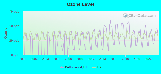
Ozone [ppb] level in 2023 was 36.8. This is about average. Closest monitor was 3.4 miles away from the city center.
| City: | 36.8 |
| U.S.: | 33.3 |
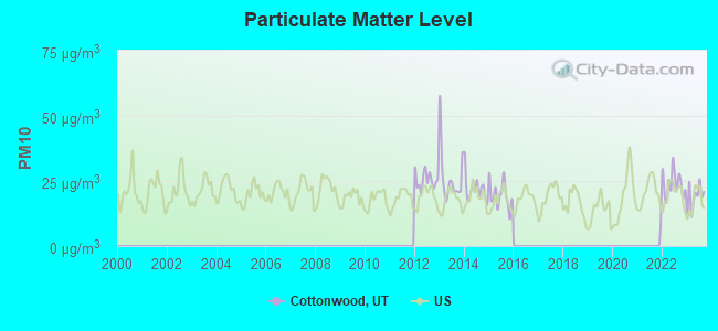
Particulate Matter (PM10) [µg/m3] level in 2023 was 18.9. This is about average. Closest monitor was 8.0 miles away from the city center.
| City: | 18.9 |
| U.S.: | 19.2 |
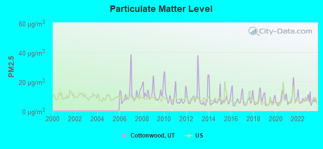
Particulate Matter (PM2.5) [µg/m3] level in 2023 was 6.87. This is about average. Closest monitor was 8.0 miles away from the city center.
| City: | 6.87 |
| U.S.: | 8.11 |
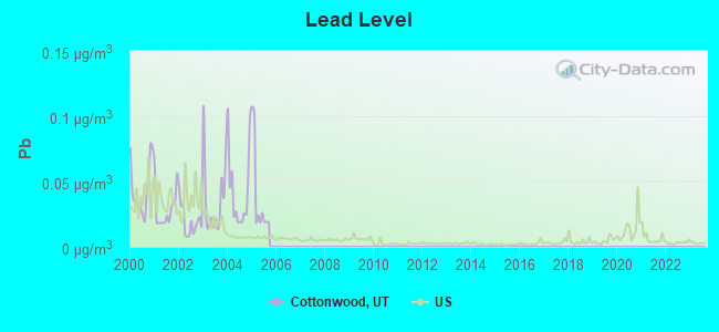
Lead (Pb) [µg/m3] level in 2005 was 0.0394. This is significantly worse than average. Closest monitor was 8.0 miles away from the city center.
| City: | 0.0394 |
| U.S.: | 0.0093 |
Earthquake activity:
Cottonwood-area historical earthquake activity is significantly above Utah state average. It is 2159% greater than the overall U.S. average.On 8/18/1959 at 06:37:13, a magnitude 7.7 (7.7 UK, Class: Major, Intensity: VIII - XII) earthquake occurred 280.6 miles away from the city center, causing $26,000,000 total damage
On 10/3/1915 at 06:52:48, a magnitude 7.6 (7.6 UK) earthquake occurred 303.8 miles away from Cottonwood center
On 10/28/1983 at 14:06:06, a magnitude 7.3 (6.2 MB, 7.3 MS, 7.0 MW) earthquake occurred 263.9 miles away from Cottonwood center, causing 2 deaths (2 shaking deaths) and 3 injuries, causing $15,000,000 total damage
On 3/28/1975 at 02:31:05, a magnitude 6.2 (6.1 MB, 6.0 MS, 6.2 ML, Class: Strong, Intensity: VII - IX) earthquake occurred 106.2 miles away from Cottonwood center
On 3/18/2020 at 13:09:31, a magnitude 5.7 (5.7 MW, Depth: 7.4 mi, Class: Moderate, Intensity: VI - VII) earthquake occurred 22.0 miles away from the city center
On 12/21/1932 at 06:10:09, a magnitude 7.2 (7.2 UK) earthquake occurred 368.4 miles away from Cottonwood center
Magnitude types: body-wave magnitude (MB), local magnitude (ML), surface-wave magnitude (MS), moment magnitude (MW)
Natural disasters:
The number of natural disasters in Salt Lake County (9) is smaller than the US average (15).Major Disasters (Presidential) Declared: 4
Emergencies Declared: 1
Causes of natural disasters: Floods: 3, Storms: 3, Fires: 2, Landslides: 2, Earthquake: 1, Hurricane: 1, Mudslide: 1, Tornado: 1, Other: 1 (Note: some incidents may be assigned to more than one category).
Hospitals and medical centers near Cottonwood:
- CANYON CREEK HOME HEALTH CARE (Home Health Center, about 5 miles away; SANDY, UT)
- GUARDIAN HOME HEALTH CARE (Home Health Center, about 8 miles away; SANDY, UT)
- ALTA VIEW HOSPITAL Acute Care Hospitals (about 8 miles away; SANDY, UT)
- MOUNTAIN LAND REHABILITATION HOME HEALTH (Home Health Center, about 8 miles away; SALT LAKE CITY, UT)
- HEALTHSOUTH HOME CARE (Home Health Center, about 8 miles away; SANDY, UT)
- HEALTHSOUTH TRANSITIONAL CARE UNIT (Nursing Home, about 8 miles away; SANDY, UT)
- MEDSHARES WESTERN UTAH (Home Health Center, about 8 miles away; SALT LAKE CITY, UT)
Amtrak station near Cottonwood:
Colleges/universities with over 2000 students nearest to Cottonwood:
- Western Governors University (about 11 miles; Salt Lake City, UT; Full-time enrollment: 31,481)
- Stevens-Henager College-Murray (about 11 miles; Murray, UT; FT enrollment: 6,395)
- Westminster College (about 13 miles; Salt Lake City, UT; FT enrollment: 2,870)
- Salt Lake Community College (about 14 miles; Salt Lake City, UT; FT enrollment: 20,797)
- University of Utah (about 14 miles; Salt Lake City, UT; FT enrollment: 28,454)
- Latter-day Saints Business College (about 16 miles; Salt Lake City, UT; FT enrollment: 2,059)
- Utah Valley University (about 22 miles; Orem, UT; FT enrollment: 24,403)
Points of interest:
Notable locations in Cottonwood: Alta Ski Area (A), Latter Day Saints Church Records Storage Area (B), Ledgemere Picnic Ground (C), Solitude Ski Area (D), Jordan Pines Recreation Site (E), Brighton Ski Area (F), Brighton Recreation Area (G), Brighton Guard Station (H), Albion Basin Campground (I), Stairs Powerplant (J), Maxfield Lodge (K), Mill B South Fork Picnic Ground (L), Redman Forest Camp (M), Alta Guard Station (N), Moss Ledge Picnic Ground (O), Tanners Flat Campground (P), Oak Ridge Picnic Ground (Q), The Birches Picnic Ground (R), Alpine Forest Camp (S), Temple Granite Quarry Historical Monument (T). Display/hide their locations on the map
Church in Cottonwood: The Church of Jesus Christ of Latter Day Saints (A). Display/hide its location on the map
Cemetery: Alta City Cemetery (1). Display/hide its location on the map
Lakes and reservoirs: Dog Lake (A), Dry Lake (B), Lake Martha (C), Lake Catherine (D), Red Pine Lake (E), Lake Desolation (F), Secret Lake (G), Lake Lillian (H). Display/hide their locations on the map
Streams, rivers, and creeks: Hogum Fork (A), Mill B North Fork (B), Mill B South Fork (C), Days Fork (D), Silver Fork (E), Broads Fork (F), Mill D North Fork (G), Mill D South Fork (H), Red Pine Fork (I). Display/hide their locations on the map
Parks in Cottonwood include: Snowbird Ski and Summer Resort (1), Glacio Park (2). Display/hide their locations on the map
| This place: | 2.6 people |
| Utah: | 3.1 people |
| This place: | 71.0% |
| Whole state: | 75.2% |
| This place: | 5.4% |
| Whole state: | 4.6% |
Likely homosexual households (counted as self-reported same-sex unmarried-partner households)
- Lesbian couples: 0.3% of all households
- Gay men: 0.5% of all households
| This place: | 2.6% |
| Whole state: | 9.4% |
| This place: | 1.3% |
| Whole state: | 3.9% |
People in group quarters in Cottonwood in 2000:
- 281 people in other workers' dormitories
- 4 people in homes for the mentally ill
- 3 people in unknown juvenile institutions
Banks with branches in Cottonwood (2011 data):
- Zions First National Bank: Old Mill Branch at 6510 Big Cottonwood Canyon Road, branch established on 1975/09/15. Info updated 2006/11/03: Bank assets: $17,531.3 mil, Deposits: $14,905.3 mil, headquarters in Salt Lake City, UT, positive income, Commercial Lending Specialization, 151 total offices, Holding Company: Zions Bancorporation
For population 15 years and over in Cottonwood:
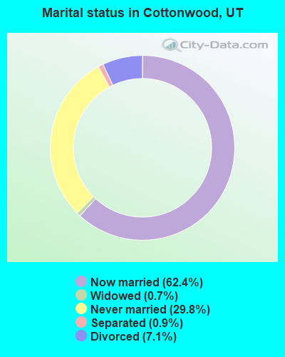
- Never married: 29.8%
- Now married: 62.4%
- Separated: 0.9%
- Widowed: 0.7%
- Divorced: 7.1%
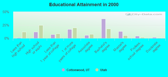
For population 25 years and over in Cottonwood:
- High school or higher: 98.4%
- Bachelor's degree or higher: 56.5%
- Graduate or professional degree: 19.5%
- Unemployed: 3.8%
- Mean travel time to work (commute): 21.8 minutes
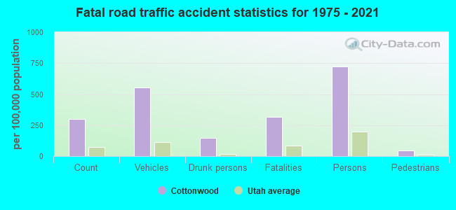
| Here: | 8.2 |
| Utah average: | 10.5 |
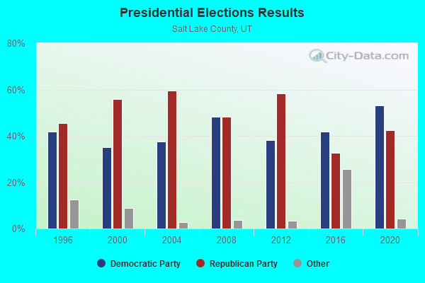
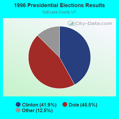
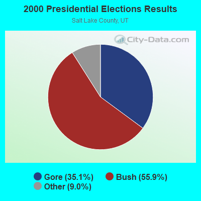
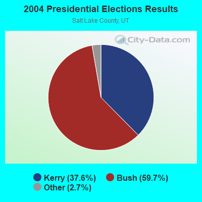
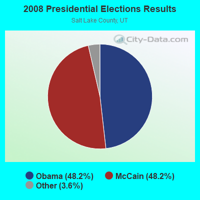

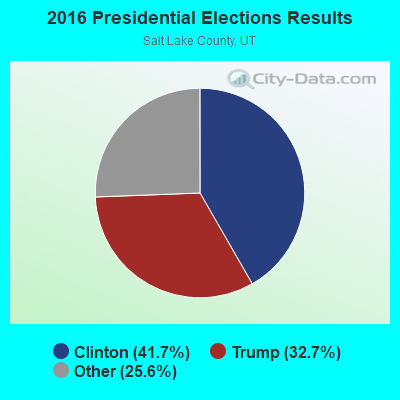
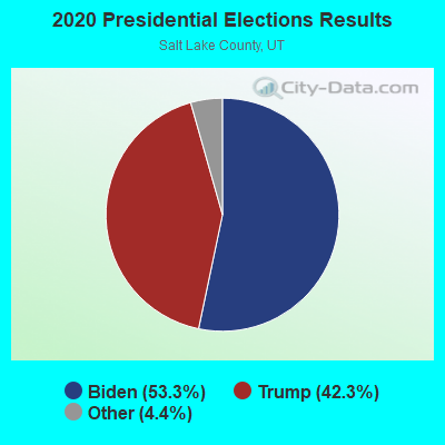
Graphs represent county-level data. Detailed 2008 Election Results
Religion statistics for Cottonwood, UT (based on Salt Lake County data)
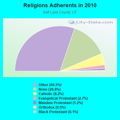
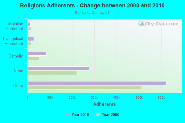
| Religion | Adherents | Congregations |
|---|---|---|
| Other | 622,807 | 1,452 |
| Catholic | 84,342 | 24 |
| Evangelical Protestant | 27,497 | 144 |
| Mainline Protestant | 12,789 | 38 |
| Orthodox | 5,352 | 7 |
| Black Protestant | 1,302 | 6 |
| None | 275,566 | - |
Food Environment Statistics:
| Salt Lake County: | 1.45 / 10,000 pop. |
| Utah: | 1.37 / 10,000 pop. |
| Salt Lake County: | 0.16 / 10,000 pop. |
| State: | 0.18 / 10,000 pop. |
| Here: | 0.47 / 10,000 pop. |
| Utah: | 0.41 / 10,000 pop. |
| This county: | 2.45 / 10,000 pop. |
| Utah: | 2.82 / 10,000 pop. |
| Salt Lake County: | 5.55 / 10,000 pop. |
| Utah: | 5.09 / 10,000 pop. |
| Here: | 6.5% |
| Utah: | 6.3% |
| Here: | 22.7% |
| Utah: | 23.6% |
6.29% of this county's 2021 resident taxpayers lived in other counties in 2020 ($73,956 average adjusted gross income)
| Here: | 6.29% |
| Utah average: | 7.95% |
0.01% of residents moved from foreign countries ($111 average AGI)
Salt Lake County: 0.01% Utah average: 0.02%
Top counties from which taxpayers relocated into this county between 2020 and 2021:
| from Utah County, UT | |
| from Davis County, UT | |
| from Weber County, UT |
6.63% of this county's 2020 resident taxpayers moved to other counties in 2021 ($71,033 average adjusted gross income)
| Here: | 6.63% |
| Utah average: | 7.39% |
0.01% of residents moved to foreign countries ($100 average AGI)
Salt Lake County: 0.01% Utah average: 0.02%
Top counties to which taxpayers relocated from this county between 2020 and 2021:
| to Utah County, UT | |
| to Davis County, UT | |
| to Tooele County, UT |
Strongest AM radio stations in Cottonwood:
- KIQN (1010 AM; 50 kW; TOOELE, UT)
- KALL (700 AM; 50 kW; NORTH SALT LAKE CITY, UT; Owner: CITICASTERS LICENSES, L.P.)
- KTKK (630 AM; 10 kW; SANDY, UT; Owner: UNITED BROADCASTING COMPANY)
- KSL (1160 AM; 50 kW; SALT LAKE CITY, UT; Owner: BONNEVILLE HOLDING COMPANY)
- KBEE (860 AM; 10 kW; SALT LAKE CITY, UT; Owner: CITADEL BROADCASTING COMPANY)
- KLLB (1510 AM; daytime; 10 kW; WEST JORDAN, UT; Owner: UNITED SECURITY FINANCIAL, INC.)
- KBJA (1640 AM; 10 kW; SANDY, UT; Owner: UNITED BROADCASTING COMPANY, INC)
- KFNZ (1320 AM; 5 kW; SALT LAKE CITY, UT; Owner: CITADEL BROADCASTING COMPANY)
- KKDS (1060 AM; 10 kW; SOUTH SALT LAKE, UT; Owner: HOLIDAY BROADCASTING COMPANY)
- KWDZ (910 AM; 5 kW; SALT LAKE CITY, UT; Owner: ABC, INC.)
- KNRS (570 AM; 5 kW; SALT LAKE CITY, UT; Owner: CITICASTERS LICENSES, L.P.)
- KSOP (1370 AM; 5 kW; SOUTH SALT LAKE, UT; Owner: KSOP, INC.)
- KMRI (1550 AM; 10 kW; WEST VALLEY CITY, UT; Owner: KMRI RADIO, LLC)
Strongest FM radio stations in Cottonwood:
- KCPX (105.7 FM; CENTERVILLE, UT; Owner: MERCURY BROADCASTING COMPANY, INC.)
- KPCW (91.9 FM; PARK CITY, UT; Owner: COMMUNITY WIRELESS OF PARK CITY, INC.)
- KXRK (96.3 FM; PROVO, UT; Owner: SIMMONS-SLC, LS, LLC)
- KQMB (102.7 FM; MIDVALE, UT; Owner: SIMMONS-SLC, LS, LLC)
- KSOP-FM (104.3 FM; SALT LAKE CITY, UT; Owner: KSOP, INC.)
- K272DP (102.3 FM; TOOELE, UT; Owner: FAMILY STATIONS, INC.)
- KRCL (90.9 FM; SALT LAKE CITY, UT; Owner: LISTENERS COMMUNITY RADIO OF UTAH)
- KBZN (97.9 FM; OGDEN, UT; Owner: CAPITOL BROADCASTING, INC.)
- KOSY-FM (106.5 FM; SPANISH FORK, UT; Owner: MERCURY BROADCASTING COMPANY, INC.)
- KRSP-FM (103.5 FM; SALT LAKE CITY, UT; Owner: SIMMONS-SLC, LS, LLC)
- KBER (101.1 FM; OGDEN, UT; Owner: CITADEL BROADCASTING COMPANY)
- KISN-FM (97.1 FM; SALT LAKE CITY, UT; Owner: CLEAR CHANNEL BROADCASTING LICENSES, INC.)
- KKAT (101.9 FM; OGDEN, UT; Owner: CITICASTERS LICENSES, L.P.)
- KSFI (100.3 FM; SALT LAKE CITY, UT; Owner: SIMMONS-SLC, LS, LLC)
- KUBL-FM (93.3 FM; SALT LAKE CITY, UT; Owner: CITADEL BROADCASTING COMPANY)
- KODJ (94.1 FM; SALT LAKE CITY, UT; Owner: CITICASTERS LICENSES, L.P.)
- KUER-FM (90.1 FM; SALT LAKE CITY, UT; Owner: UNIVERSITY OF UTAH)
- KBYU-FM (89.1 FM; PROVO, UT; Owner: BRIGHAM YOUNG UNIVERSITY)
- KURR (99.5 FM; BOUNTIFUL, UT; Owner: CITICASTERS LICENSES, L.P.)
- KBEE-FM (98.7 FM; SALT LAKE CITY, UT; Owner: CITADEL BROADCASTING COMPANY)
TV broadcast stations around Cottonwood:
- KUTV (Channel 2; SALT LAKE CITY, UT; Owner: KUTV HOLDINGS, INC.)
- K59GS (Channel 59; SALT LAKE CITY, UT; Owner: ALPHA & OMEGA COMMUNICATIONS, LLC)
- KEJT-LP (Channel 48; SALT LAKE CITY, UT; Owner: TELEMUNDO OF NORTHERN CALIFORNIA LICENSE CORP.)
- KULC (Channel 9; OGDEN, UT; Owner: UTAH STATE BOARD OF REGENTS)
- KUED (Channel 7; SALT LAKE CITY, UT; Owner: UNIVERSITY OF UTAH)
- KUWB (Channel 30; OGDEN, UT; Owner: ACME TV LICENSES OF UTAH, LLC)
- K66FN (Channel 66; SALT LAKE CITY, UT; Owner: AZTECA BROADCASTING CORPORATION)
- KUCL-LP (Channel 26; SALT LAKE CITY, UT; Owner: CHRISTIAN LIFE BROADCASTING)
FAA Registered Aircraft:
1- Aircraft: CESSNA 182 (Category: Land, Seats: 4, Weight: Up to 12,499 Pounds, Speed: 119 mph), Engine: CONT MOTOR O-470 SERIES (230 HP) (Reciprocating)
N-Number: 5687B, N5687B, N-5687B, Serial Number: 33687, Year manufactured: 1956, Airworthiness Date: 09/14/1956, Certificate Issue Date: 01/28/1987
Registrant (Individual): Keith J Osojnak, 2601 East 6485 South, Cottonwood, UT 84121
2002 - 2015 National Fire Incident Reporting System (NFIRS) incidents
- Fire incident types reported to NFIRS in Cottonwood, UT
- 8151.3%Structure Fires
- 3622.8%Outside Fires
- 2415.2%Other
- 1710.8%Mobile Property/Vehicle Fires
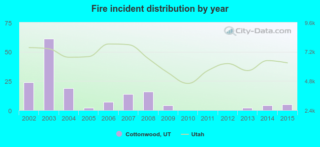 Based on the data from the years 2002 - 2015 the average number of fire incidents per year is 11. The highest number of reported fires - 61 took place in 2003, and the least - 0 in 2010. The data has a decreasing trend.
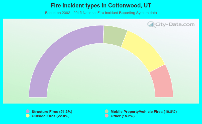 When looking into fire subcategories, the most reports belonged to: Structure Fires (51.3%), and Outside Fires (22.8%).
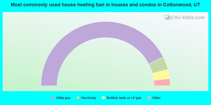
- 85.1%Utility gas
- 6.7%Electricity
- 4.6%Bottled, tank, or LP gas
- 2.4%Wood
- 0.8%Solar energy
- 0.3%Coal or coke
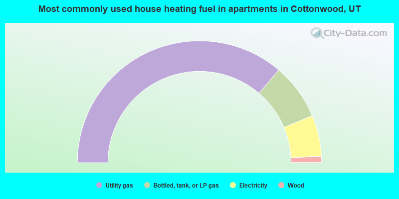
- 72.6%Utility gas
- 14.9%Bottled, tank, or LP gas
- 10.9%Electricity
- 1.7%Wood
Cottonwood compared to Utah state average:
- Median household income above state average.
- Median house value above state average.
- Unemployed percentage significantly below state average.
- Black race population percentage below state average.
- Hispanic race population percentage significantly below state average.
- Median age above state average.
- Foreign-born population percentage significantly below state average.
- Renting percentage below state average.
- Length of stay since moving in significantly above state average.
- Number of rooms per house significantly below state average.
- House age significantly below state average.
- Percentage of population with a bachelor's degree or higher significantly above state average.
Cottonwood on our top lists:
- #3 on the list of "Top 101 cities with largest percentage of females in occupations: sales representatives, services, wholesale and manufacturing (population 5,000+)"
- #3 on the list of "Top 101 cities with largest percentage of males in occupations: waiters and waitresses (population 5,000+)"
- #3 on the list of "Top 101 cities with largest percentage of females in industries: paper and paper products merchant wholesalers (population 5,000+)"
- #3 on the list of "Top 101 cities with largest percentage of females in industries: miscellaneous durable goods merchant wholesalers (population 5,000+)"
- #6 on the list of "Top 101 cities with largest percentage of females in occupations: pipelayers, plumbers, pipefitters, and steamfitters (population 5,000+)"
- #6 on the list of "Top 101 cities with largest percentage of females in industries: electrical and electronic goods merchant wholesalers (population 5,000+)"
- #9 on the list of "Top 101 cities with largest percentage of males in occupations: air transportation workers (population 5,000+)"
- #9 on the list of "Top 101 cities with the largest percentage of people in other workers' dormitories (population 1,000+)"
- #15 on the list of "Top 101 cities with largest percentage of males in industries: air transportation (population 5,000+)"
- #16 on the list of "Top 101 cities with largest percentage of males in occupations: advertising, marketing, promotions, public relations, and sales managers (population 5,000+)"
- #16 on the list of "Top 101 cities with largest percentage of females in occupations: electricians (population 5,000+)"
- #22 on the list of "Top 101 cities with largest percentage of males in industries: hardware, plumbing and heating equipment, and supplies merchant wholesalers (population 5,000+)"
- #23 on the list of "Top 101 cities with largest percentage of females in industries: air transportation (population 5,000+)"
- #32 on the list of "Top 101 cities with largest percentage of males in industries: health care (population 5,000+)"
- #35 on the list of "Top 101 cities with largest percentage of females in industries: book stores and news dealers (population 5,000+)"
- #37 on the list of "Top 101 cities with largest percentage of females in industries: clothing and accessories, including shoe, stores (population 5,000+)"
- #40 on the list of "Top 101 cities with the most cars per house, population 5,000+"
- #52 on the list of "Top 101 cities with largest percentage of females in industries: broadcasting and telecommunications (population 5,000+)"
- #53 on the list of "Top 101 cities with largest percentage of males in industries: jewelry, luggage, and leather goods stores (population 5,000+)"
- #57 on the list of "Top 101 cities with largest percentage of females in industries: office supplies and stationery stores (population 5,000+)"
- #58 (84121) on the list of "Top 101 zip codes with the largest charity contributions deductions as a percentage of AGI in 2012 (pop 5,000+)"
- #68 (84121) on the list of "Top 101 zip codes with the largest percentage of Danish first ancestries (pop 5,000+)"
- #1 on the list of "Top 101 counties with the most Other adherents"
- #1 on the list of "Top 101 counties with the most Other congregations"
- #4 on the list of "Top 101 counties with the lowest percentage of residents that smoked 100+ cigarettes in their lives"
- #11 on the list of "Top 101 counties with the highest Nitrogen Dioxide air pollution readings in 2012 (ppm)"
- #14 on the list of "Top 101 counties with the highest number of births per 1000 residents 2007-2013"

|
Total of 6 patent applications in 2008-2024.