Crescent, Iowa
Submit your own pictures of this city and show them to the world
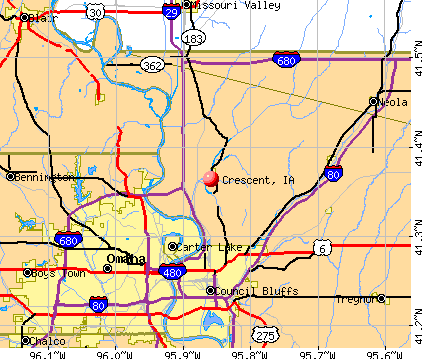
- OSM Map
- General Map
- Google Map
- MSN Map
Population change since 2000: +16.2%
| Males: 299 | |
| Females: 325 |
| Median resident age: | 43.8 years |
| Iowa median age: | 38.9 years |
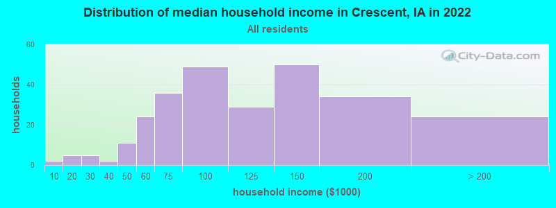
| Crescent: | $100,571 |
| IA: | $69,588 |
Estimated per capita income in 2022: $46,928 (it was $24,548 in 2000)
Crescent city income, earnings, and wages data
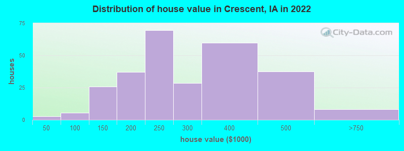
Estimated median house or condo value in 2022: $274,912 (it was $104,400 in 2000)
| Crescent: | $274,912 |
| IA: | $194,600 |
Mean prices in 2022: all housing units: $230,564; detached houses: $229,232
Median gross rent in 2022: $1,190.
Detailed information about poverty and poor residents in Crescent, IA
Compare current foreclosures near Crescent, IA:
| Photo | Address | Area | Beds / Baths | Price | Details |
|---|---|---|---|---|---|

|
#1
Old Lincoln Hwy
Crescent, IA 51526
|
1,845 sq. feet
|
1 baths 3 beds |
show details | |

|
#2
Leisure Ave
Crescent, IA 51526
|
970 sq. feet
|
1 baths 3 beds |
show details | |

|
#3
Stutsman St
Council Bluffs, IA 51503
|
1,248 sq. feet
|
1 baths 3 beds |
$66,100
|
show details |

|
#4
S 22nd St
Omaha, NE 68107
|
2,350 sq. feet
|
3 baths 4 beds |
show details | |

|
#5
N 36th St
Omaha, NE 68112
|
- sq. feet
|
1 baths 2 beds |
show details | |

|
#6
South 13th Court
Omaha, NE 68108
|
- sq. feet
|
- baths - beds |
$100,000
|
show details |

|
#7
Fort St
Omaha, NE 68104
|
1,453 sq. feet
|
1 baths 3 beds |
show details | |

|
#8
Middle Ferry Rd
Council Bluffs, IA 51501
|
1,385 sq. feet
|
2 baths 2 beds |
show details | |

|
#9
5th Ave
Council Bluffs, IA 51501
|
1,167 sq. feet
|
2 baths 2 beds |
show details | |

|
#10
S 33rd St
Omaha, NE 68107
|
1,094 sq. feet
|
1 baths 4 beds |
show details |
| Photo | Address | Area | Beds / Baths | Price | Details |
|---|---|---|---|---|---|

|
#11
Holmes St
Omaha, NE 68117
|
1,071 sq. feet
|
2 baths 3 beds |
show details | |

|
#12
Roanoke Blvd
Omaha, NE 68164
|
1,832 sq. feet
|
2 baths 3 beds |
show details | |

|
#13
S 62nd Ave
Omaha, NE 68117
|
840 sq. feet
|
1 baths 3 beds |
show details | |

|
#14
X St
Omaha, NE 68107
|
1,332 sq. feet
|
1 baths 4 beds |
show details | |

|
#15
Roanoke Blvd
Omaha, NE 68164
|
1,902 sq. feet
|
2 baths 3 beds |
show details | |

|
#16
S 35th St
Omaha, NE 68107
|
2,114 sq. feet
|
2 baths 4 beds |
show details | |

|
#17
Polk St
Omaha, NE 68107
|
1,216 sq. feet
|
1 baths 3 beds |
show details | |

|
#18
S 62nd St
Omaha, NE 68117
|
840 sq. feet
|
1 baths 3 beds |
show details | |

|
#19
W St
Omaha, NE 68107
|
720 sq. feet
|
1 baths 2 beds |
show details | |

|
#20
Newport Ave
Omaha, NE 68164
|
1,491 sq. feet
|
2 baths 3 beds |
show details |
| Photo | Address | Area | Beds / Baths | Price | Details |
|---|---|---|---|---|---|

|
#21
W St
Omaha, NE 68107
|
920 sq. feet
|
1 baths 3 beds |
show details | |

|
#22
S 76th Ave
Omaha, NE 68124
|
1,336 sq. feet
|
2 baths 3 beds |
show details | |

|
#23
S St
Omaha, NE 68107
|
864 sq. feet
|
1 baths 2 beds |
show details | |

|
#24
O St
Omaha, NE 68117
|
720 sq. feet
|
1 baths 2 beds |
show details | |

|
#25
R St
Omaha, NE 68107
|
1,358 sq. feet
|
1 baths 3 beds |
show details | |

|
#26
S St
Omaha, NE 68107
|
1,148 sq. feet
|
1 baths 4 beds |
show details | |

|
#27
Rambleridge Rd
Omaha, NE 68164
|
1,594 sq. feet
|
2 baths 3 beds |
show details | |

|
#28
Grover St, Trlr 66
Omaha, NE 68106
|
840 sq. feet
|
1 baths 2 beds |
show details | |

|
#29
N 90th St
Omaha, NE 68114
|
2,364 sq. feet
|
2 baths 3 beds |
show details | |

|
#30
R St
Omaha, NE 68107
|
2,110 sq. feet
|
2 baths 5 beds |
show details |
| Photo | Address | Area | Beds / Baths | Price | Details |
|---|---|---|---|---|---|

|
#31
Parker St
Omaha, NE 68114
|
3,308 sq. feet
|
3 baths 5 beds |
show details | |

|
#32
N 112th St
Omaha, NE 68164
|
1,464 sq. feet
|
2 baths 3 beds |
show details | |

|
#33
Hackberry Rd
Mc Clelland, IA 51548
|
1,162 sq. feet
|
1 baths 2 beds |
show details | |

|
#34
Bauman Cir
Omaha, NE 68164
|
1,399 sq. feet
|
2 baths 3 beds |
show details | |

|
#35
Sarpy Ave
Bellevue, NE 68147
|
1,438 sq. feet
|
1 baths 2 beds |
show details | |

|
#36
S 32nd Ave
Bellevue, NE 68147
|
1,586 sq. feet
|
1 baths 3 beds |
show details | |

|
#37
Chandler Hills Dr
Bellevue, NE 68147
|
1,032 sq. feet
|
1 baths 2 beds |
show details | |

|
#38
Greene Ave
Bellevue, NE 68147
|
1,623 sq. feet
|
2 baths 3 beds |
show details | |

|
#39
N 126th Plz # 389
Omaha, NE 68164
|
1,216 sq. feet
|
2 baths 3 beds |
show details | |

|
#40
Southern Manor Dr
Omaha, NE 68117
|
1,222 sq. feet
|
1 baths 3 beds |
show details |
| Photo | Address | Area | Beds / Baths | Price | Details |
|---|---|---|---|---|---|

|
#41
Sun Valley Dr
Omaha, NE 68157
|
1,422 sq. feet
|
1 baths 3 beds |
show details | |

|
#42
Laurie Cir
Omaha, NE 68124
|
950 sq. feet
|
1 baths 3 beds |
show details | |

|
#43
N 128th St
Omaha, NE 68164
|
1,449 sq. feet
|
2 baths 3 beds |
show details | |

|
#44
South 90th Avenu
Omaha, NE 68124
|
928 sq. feet
|
1 baths 3 beds |
show details | |

|
#45
Wirt St
Omaha, NE 68164
|
1,593 sq. feet
|
2 baths 3 beds |
show details | |

|
#46
N 128th St
Omaha, NE 68164
|
1,624 sq. feet
|
2 baths 3 beds |
show details | |

|
#47
Park Lane Cir
Omaha, NE 68164
|
1,418 sq. feet
|
2 baths 2 beds |
show details | |

|
#48
Irene St
Bellevue, NE 68147
|
1,376 sq. feet
|
1 baths 3 beds |
show details | |

|
#49
Nebraska Ave
Omaha, NE 68164
|
1,253 sq. feet
|
2 baths 3 beds |
show details | |

|
Check over 1 million property listings on Foreclosure.com!
|
browse all offers | |||


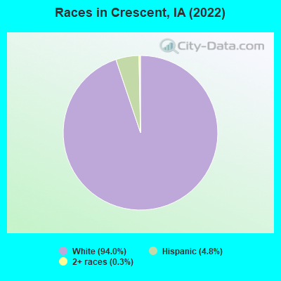
- 60994.0%White alone
- 314.8%Hispanic
- 20.3%Two or more races
Races in Crescent detailed stats: ancestries, foreign born residents, place of birth
 Recent articles from our blog. Our writers, many of them Ph.D. graduates or candidates, create easy-to-read articles on a wide variety of topics.

 | Moving to Quadcities area this fall to begin school at palmer, need help !! (10 replies) |
| Moving to IC or Davenport (17 replies) |
| Downtown Davenport redevelopment continues with another new project... (8 replies) |
| Relocating soon..Help! Best area and Schools? (7 replies) |
| Black on Black Prejudice in Des Moines... (50 replies) |
| Moving to Davenport, IA (4 replies) |
Latest news from Crescent, IA collected exclusively by city-data.com from local newspapers, TV, and radio stations
Ancestries: German (33.2%), Irish (31.7%), Dutch (7.3%), English (5.7%), American (3.9%), Italian (3.0%).
Current Local Time: CST time zone
Incorporated on 10/16/1959
Land area: 1.26 square miles.
Population density: 496 people per square mile (low).
Median real estate property taxes paid for housing units with mortgages in 2022: $4,408 (1.5%)
Median real estate property taxes paid for housing units with no mortgage in 2022: $2,880 (1.2%)
Nearest city with pop. 50,000+: Council Bluffs, IA  (7.6 miles , pop. 58,268).
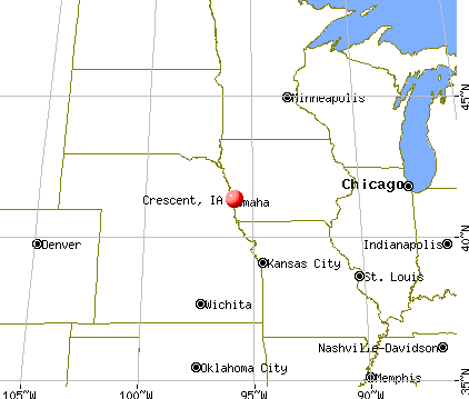
Nearest city with pop. 200,000+: Omaha, NE (10.7 miles , pop. 390,007).
Nearest city with pop. 1,000,000+: Chicago, IL (424.2 miles , pop. 2,896,016).
Nearest cities:
), )Latitude: 41.36 N, Longitude: 95.86 W
Area code: 712

| Here: | 2.8% |
| Iowa: | 2.7% |
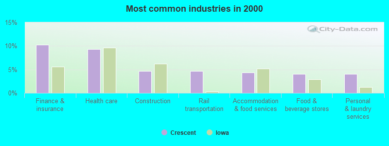
- Finance & insurance (10.2%)
- Health care (9.3%)
- Construction (4.7%)
- Rail transportation (4.7%)
- Accommodation & food services (4.3%)
- Food & beverage stores (4.0%)
- Personal & laundry services (4.0%)
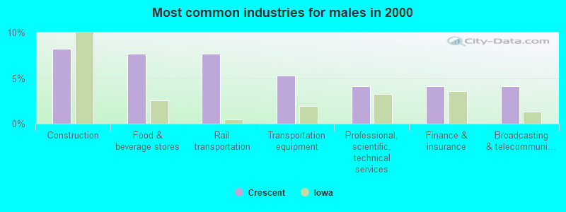
- Construction (8.2%)
- Food & beverage stores (7.6%)
- Rail transportation (7.6%)
- Transportation equipment (5.3%)
- Professional, scientific, technical services (4.1%)
- Finance & insurance (4.1%)
- Broadcasting & telecommunications (4.1%)
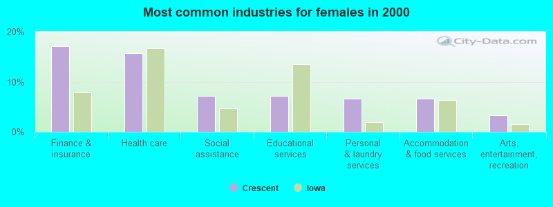
- Finance & insurance (17.1%)
- Health care (15.8%)
- Social assistance (7.2%)
- Educational services (7.2%)
- Personal & laundry services (6.6%)
- Accommodation & food services (6.6%)
- Arts, entertainment, recreation (3.3%)
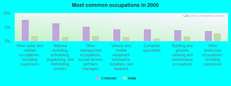
- Other sales and related occupations, including supervisors (7.8%)
- Material recording, scheduling, dispatching, and distributing workers (6.5%)
- Other management occupations, except farmers and farm managers (5.3%)
- Vehicle and mobile equipment mechanics, installers, and repairers (4.3%)
- Computer specialists (4.3%)
- Building and grounds cleaning and maintenance occupations (4.0%)
- Other production occupations, including supervisors (3.7%)

- Material recording, scheduling, dispatching, and distributing workers (8.8%)
- Vehicle and mobile equipment mechanics, installers, and repairers (8.2%)
- Other sales and related occupations, including supervisors (6.5%)
- Other construction workers and helpers (6.5%)
- Other production occupations, including supervisors (5.9%)
- Other management occupations, except farmers and farm managers (5.3%)
- Driver/sales workers and truck drivers (4.7%)

- Other sales and related occupations, including supervisors (9.2%)
- Information and record clerks, except customer service representatives (5.9%)
- Computer specialists (5.3%)
- Other management occupations, except farmers and farm managers (5.3%)
- Registered nurses (4.6%)
- Building and grounds cleaning and maintenance occupations (4.6%)
- Preschool, kindergarten, elementary, and middle school teachers (3.9%)
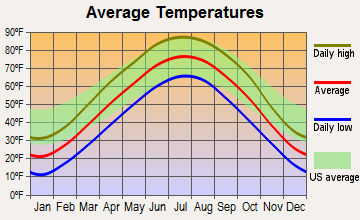
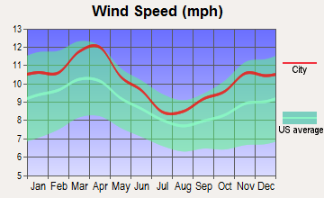
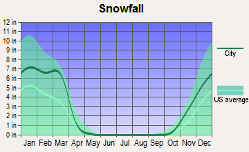
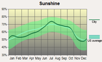
Average climate in Crescent, Iowa
Based on data reported by over 4,000 weather stations

(lower is better)
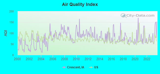
Air Quality Index (AQI) level in 2023 was 104. This is significantly worse than average.
| City: | 104 |
| U.S.: | 73 |
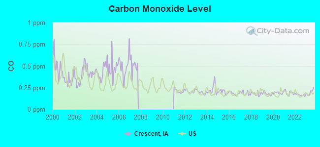
Carbon Monoxide (CO) [ppm] level in 2023 was 0.195. This is better than average. Closest monitor was 6.6 miles away from the city center.
| City: | 0.195 |
| U.S.: | 0.251 |
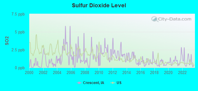
Sulfur Dioxide (SO2) [ppb] level in 2023 was 0.576. This is significantly better than average. Closest monitor was 5.0 miles away from the city center.
| City: | 0.576 |
| U.S.: | 1.515 |
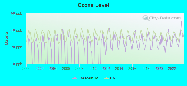
Ozone [ppb] level in 2023 was 35.1. This is about average. Closest monitor was 5.0 miles away from the city center.
| City: | 35.1 |
| U.S.: | 33.3 |
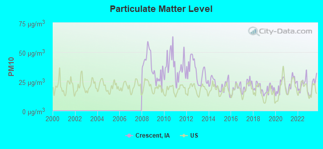
Particulate Matter (PM10) [µg/m3] level in 2023 was 21.9. This is about average. Closest monitor was 6.5 miles away from the city center.
| City: | 21.9 |
| U.S.: | 19.2 |
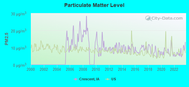
Particulate Matter (PM2.5) [µg/m3] level in 2023 was 8.58. This is about average. Closest monitor was 7.1 miles away from the city center.
| City: | 8.58 |
| U.S.: | 8.11 |
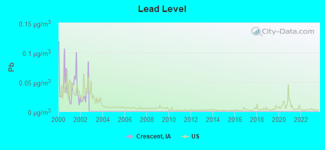
Lead (Pb) [µg/m3] level in 2002 was 0.0298. This is significantly worse than average. Closest monitor was 7.7 miles away from the city center.
| City: | 0.0298 |
| U.S.: | 0.0093 |
Tornado activity:
Crescent-area historical tornado activity is near Iowa state average. It is 88% greater than the overall U.S. average.
On 5/6/1975, a category F4 (max. wind speeds 207-260 mph) tornado 10.2 miles away from the Crescent city center killed 3 people and injured 133 people and caused between $50,000 and $500,000 in damages.
On 6/26/1976, a category F4 tornado 14.7 miles away from the city center injured 6 people and caused between $500,000 and $5,000,000 in damages.
Earthquake activity:
Crescent-area historical earthquake activity is significantly above Iowa state average. It is 303% greater than the overall U.S. average.On 9/3/2016 at 12:02:44, a magnitude 5.8 (5.8 MW, Depth: 3.5 mi, Class: Moderate, Intensity: VI - VII) earthquake occurred 346.4 miles away from the city center
On 11/6/2011 at 03:53:10, a magnitude 5.7 (5.7 MW, Depth: 3.2 mi) earthquake occurred 406.3 miles away from the city center
On 6/22/2019 at 08:50:24, a magnitude 4.6 (4.6 MW, Depth: 1.9 mi, Class: Light, Intensity: IV - V) earthquake occurred 239.7 miles away from the city center
On 11/3/2002 at 20:41:56, a magnitude 4.3 (4.3 MB, Depth: 3.1 mi) earthquake occurred 183.7 miles away from Crescent center
On 11/12/2014 at 21:40:00, a magnitude 4.9 (4.9 MW, Depth: 2.5 mi) earthquake occurred 298.3 miles away from the city center
On 12/17/2009 at 02:53:42, a magnitude 3.6 (3.6 MB, Depth: 3.1 mi, Class: Light, Intensity: II - III) earthquake occurred 66.2 miles away from Crescent center
Magnitude types: body-wave magnitude (MB), moment magnitude (MW)
Natural disasters:
The number of natural disasters in Pottawattamie County (22) is greater than the US average (15).Major Disasters (Presidential) Declared: 19
Emergencies Declared: 2
Causes of natural disasters: Floods: 15, Storms: 12, Tornadoes: 7, Snows: 2, Winds: 2, Winter Storms: 2, Heavy Rain: 1, Hurricane: 1, Snowstorm: 1, Other: 1 (Note: some incidents may be assigned to more than one category).

Hospitals and medical centers near Crescent:
- MIDLANDS LIVING CENTER L L C (Nursing Home, about 6 miles away; COUNCIL BLUFFS, IA)
- FLORENCE HOME (Nursing Home, about 6 miles away; OMAHA, NE)
- HIDDEN HILLS HEALTH AND REHABILITATION CENTER (Nursing Home, about 6 miles away; OMAHA, NE)
- NORTH CREST LIVING CENTER (Nursing Home, about 7 miles away; COUNCIL BLUFFS, IA)
- JENNIE EDMUNDSON HOSPITAL Acute Care Hospitals (about 7 miles away; COUNCIL BLUFFS, IA)
- ALEGENT HEALTH MERCY HOSPITAL Acute Care Hospitals (about 7 miles away; COUNCIL BLUFFS, IA)
- HOSPICE OF THE MIDLANDS (Hospital, about 7 miles away; COUNCIL BLUFFS, IA)
Operable nuclear power plant near Crescent:
- 11 miles: Fort Calhoun in Fort Calhoun, NE.
Colleges/universities with over 2000 students nearest to Crescent:
- Metropolitan Community College Area (about 7 miles; Omaha, NE; Full-time enrollment: 12,236)
- Iowa Western Community College (about 7 miles; Council Bluffs, IA; FT enrollment: 5,344)
- Creighton University (about 9 miles; Omaha, NE; FT enrollment: 5,370)
- University of Nebraska Medical Center (about 10 miles; Omaha, NE; FT enrollment: 2,815)
- University of Nebraska at Omaha (about 11 miles; Omaha, NE; FT enrollment: 12,073)
- Bellevue University (about 16 miles; Bellevue, NE; FT enrollment: 7,139)
- Nebraska Wesleyan University (about 55 miles; Lincoln, NE; FT enrollment: 2,072)
Public elementary/middle school in Crescent:
- CRESCENT ELEMENTARY SCHOOL (Students: 117, Location: 401 EAST WELCH STREET, Grades: PK-5)
Points of interest:
Notable location: Crescent Volunteer Fire and Rescue (A). Display/hide its location on the map
Church in Crescent: Reorganized Church of Jesus Christ of Latter Day Saints (A). Display/hide its location on the map
Cemetery: Crescent Cemetery (1). Display/hide its location on the map
Drinking water stations with addresses in Crescent and their reported violations in the past:
MT. CRESCENT SKI AREA (Population served: 119, Groundwater):Past monitoring violations:
- Monitoring, Repeat Major (TCR) - Between JUL-2012 and AUG-2012, Contaminant: Coliform (TCR). Follow-up actions: St Public Notif requested (SEP-20-2012), St Formal NOV issued (SEP-20-2012), St Compliance achieved (OCT-08-2013)
- Monitoring, Check/Repeat/Confirmation - Between APR-2004 and JAN-2005, Contaminant: Nitrate. Follow-up actions: St Formal NOV issued (FEB-15-2005), St Public Notif requested (FEB-15-2005), St Compliance achieved (AUG-23-2005)
- 11 routine major monitoring violations
- 4 regular monitoring violations
| This city: | 2.6 people |
| Iowa: | 2.4 people |
| This city: | 75.3% |
| Whole state: | 64.7% |
| This city: | 8.1% |
| Whole state: | 6.7% |
Likely homosexual households (counted as self-reported same-sex unmarried-partner households)
- Lesbian couples: 1.3% of all households
- Gay men: 0.0% of all households
Banks with branches in Crescent (2011 data):
- American National Bank: Crescent Branch at 101 Old Lincoln Highway, branch established on 1989/12/31. Info updated 2012/02/13: Bank assets: $1,928.1 mil, Deposits: $1,460.0 mil, headquarters in Omaha, NE, positive income, Commercial Lending Specialization, 34 total offices, Holding Company: American National Corporation
For population 15 years and over in Crescent:
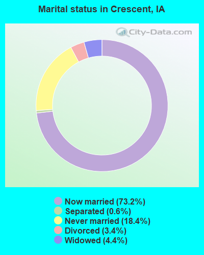
- Never married: 18.4%
- Now married: 73.2%
- Separated: 0.6%
- Widowed: 4.4%
- Divorced: 3.4%
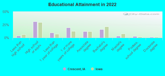
For population 25 years and over in Crescent:
- High school or higher: 96.2%
- Bachelor's degree or higher: 22.7%
- Graduate or professional degree: 6.7%
- Unemployed: 2.7%
- Mean travel time to work (commute): 15.7 minutes
| Here: | 8.6 |
| Iowa average: | 10.5 |
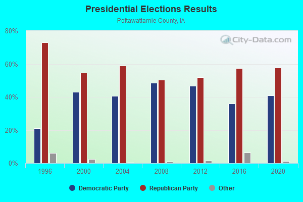
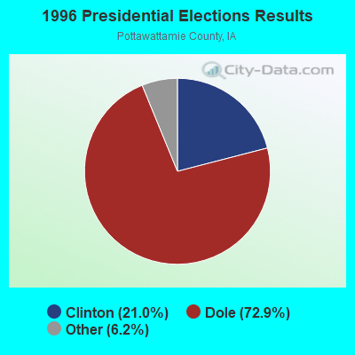
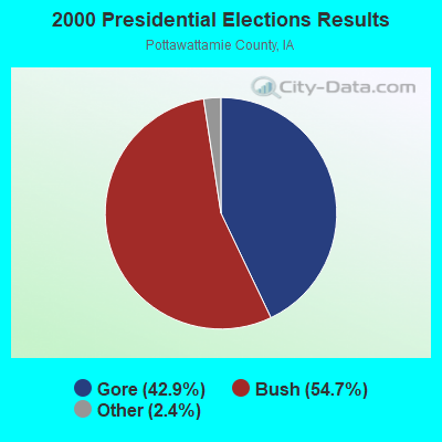
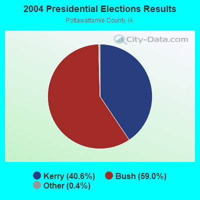
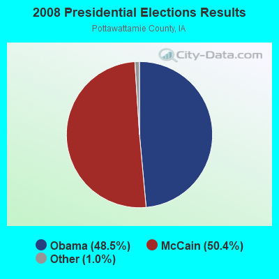
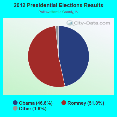


Graphs represent county-level data. Detailed 2008 Election Results
Religion statistics for Crescent, IA (based on Pottawattamie County data)
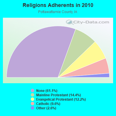
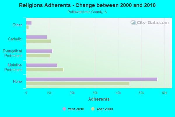
| Religion | Adherents | Congregations |
|---|---|---|
| Mainline Protestant | 13,430 | 43 |
| Evangelical Protestant | 11,369 | 56 |
| Catholic | 8,947 | 9 |
| Other | 2,384 | 9 |
| Orthodox | 80 | 1 |
| None | 56,948 | - |
Food Environment Statistics:
| Pottawattamie County: | 1.68 / 10,000 pop. |
| Iowa: | 2.14 / 10,000 pop. |
| Here: | 0.22 / 10,000 pop. |
| Iowa: | 0.23 / 10,000 pop. |
| Here: | 0.11 / 10,000 pop. |
| Iowa: | 0.43 / 10,000 pop. |
| Pottawattamie County: | 5.71 / 10,000 pop. |
| State: | 5.55 / 10,000 pop. |
| Here: | 4.92 / 10,000 pop. |
| Iowa: | 8.01 / 10,000 pop. |
| This county: | 8.0% |
| State: | 7.8% |
| Here: | 29.7% |
| Iowa: | 27.3% |
| Pottawattamie County: | 16.7% |
| Iowa: | 14.5% |
| Local government employment and payroll (March 2022) | |||||
| Function | Full-time employees | Monthly full-time payroll | Average yearly full-time wage | Part-time employees | Monthly part-time payroll |
|---|---|---|---|---|---|
| Financial Administration | 1 | $4,531 | $54,372 | 0 | $0 |
| Streets and Highways | 1 | $4,490 | $53,880 | 0 | $0 |
| Totals for Government | 2 | $9,021 | $54,126 | 0 | $0 |
Crescent government finances - Expenditure in 2017 (per resident):
- Current Operations - Water Utilities: $156,000 ($250.00)
General - Other: $136,000 ($217.95)
Sewerage: $108,000 ($173.08)
Regular Highways: $61,000 ($97.76)
Local Fire Protection: $38,000 ($60.90)
Financial Administration: $33,000 ($52.88)
General Public Buildings: $31,000 ($49.68)
Parks and Recreation: $28,000 ($44.87)
Health - Other: $28,000 ($44.87)
Judicial and Legal Services: $19,000 ($30.45)
Police Protection: $11,000 ($17.63)
Libraries: $2,000 ($3.21)
- General - Interest on Debt: $68,000 ($108.97)
- Other Capital Outlay - Regular Highways: $5,000 ($8.01)
- Total Salaries and Wages: $96,000 ($153.85)
- Water Utilities - Interest on Debt: $6,000 ($9.62)
Crescent government finances - Revenue in 2017 (per resident):
- Charges - Sewerage: $117,000 ($187.50)
Other: $61,000 ($97.76)
Parks and Recreation: $11,000 ($17.63)
- Local Intergovernmental - Other: $116,000 ($185.90)
- Miscellaneous - General Revenue - Other: $45,000 ($72.12)
Fines and Forfeits: $2,000 ($3.21)
Rents: $1,000 ($1.60)
- Revenue - Water Utilities: $153,000 ($245.19)
- State Intergovernmental - Highways: $77,000 ($123.40)
General Local Government Support: $4,000 ($6.41)
- Tax - Property: $265,000 ($424.68)
General Sales and Gross Receipts: $66,000 ($105.77)
Public Utilities Sales: $11,000 ($17.63)
Other License: $7,000 ($11.22)
Crescent government finances - Debt in 2017 (per resident):
- Long Term Debt - Beginning Outstanding - Unspecified Public Purpose: $1,471,000 ($2357.37)
Outstanding Unspecified Public Purpose: $1,363,000 ($2184.29)
Retired Unspecified Public Purpose: $108,000 ($173.08)
Crescent government finances - Cash and Securities in 2017 (per resident):
- Other Funds - Cash and Securities: $997,000 ($1597.76)
Strongest AM radio stations in Crescent:
- KYDZ (1180 AM; 25 kW; BELLEVUE, NE; Owner: WAITT RADIO, INC.)
- KKAR (1290 AM; 50 kW; OMAHA, NE; Owner: WAITT RADIO, INC.)
- KFAB (1110 AM; 50 kW; OMAHA, NE; Owner: CAPSTAR TX LIMITED PARTNERSHIP)
- KOMJ (590 AM; 5 kW; OMAHA, NE; Owner: JOURNAL BROADCAST CORPORATION)
- KOIL (1020 AM; 50 kW; PLATTSMOUTH, NE; Owner: WAITT RADIO, INC.)
- KLNG (1560 AM; daytime; 10 kW; COUNCIL BLUFFS, IA)
- KOZN (1620 AM; 10 kW; BELLEVUE, NE; Owner: WAITT RADIO, INC.)
- KCRO (660 AM; 1 kW; OMAHA, NE; Owner: ETERNAL BROADCASTING, LLC)
- KOSR (1490 AM; 1 kW; OMAHA, NE; Owner: JOURNAL BROADCAST CORPORATION)
- KHLP (1420 AM; 1 kW; OMAHA, NE; Owner: JOURNAL BROADCAST CORPORATION)
- WHO (1040 AM; 50 kW; DES MOINES, IA; Owner: CITICASTERS LICENSES, L.P.)
- WHB (810 AM; 50 kW; KANSAS CITY, MO; Owner: UNION BROADCASTING, INC.)
- KMA (960 AM; 5 kW; SHENANDOAH, IA; Owner: KMA BROADCASTING L.P.)
Strongest FM radio stations in Crescent:
- KMLV (88.1 FM; RALSTON, NE; Owner: EDUCATIONAL MEDIA FOUNDATION)
- KGOR (99.9 FM; OMAHA, NE; Owner: CAPSTAR TX LIMITED PARTNERSHIP)
- KEZO-FM (92.3 FM; OMAHA, NE; Owner: JOURNAL BROADCAST CORPORATION)
- KQKQ-FM (98.5 FM; COUNCIL BLUFFS, IA; Owner: WAITT RADIO, INC.)
- KQCH (94.1 FM; OMAHA, NE; Owner: JOURNAL BROADCAST CORPORATION)
- KIWR (89.7 FM; COUNCIL BLUFFS, IA; Owner: IOWA WESTERN COMMUNITY COLLEGE)
- KSRZ (104.5 FM; OMAHA, NE; Owner: JOURNAL BROADCAST CORPORATION)
- KRQC (93.3 FM; BENNINGTON, NE; Owner: CAPSTAR TX LIMITED PARTNERSHIP)
- KVNO (90.7 FM; OMAHA, NE; Owner: THE BOARD OF REGENTS OF UNIV. OF NEBRASKA)
- KIOS-FM (91.5 FM; OMAHA, NE; Owner: DOUGLAS COUNTY SCHOOL DISTRICT 001)
- KVSS (88.9 FM; OMAHA, NE; Owner: VSS CATHOLIC COMMUNICATIONS, INC.)
- KKCD (105.9 FM; OMAHA, NE; Owner: JOURNAL BROADCAST CORPORATION)
- KXKT (103.7 FM; GLENWOOD, IA; Owner: CAPSTAR TX LIMITED PARTNERSHIP)
- K299AK (107.7 FM; OMAHA, NE; Owner: BAER COMMUNICATIONS, INC.)
- KEFM (96.1 FM; OMAHA, NE; Owner: WEBSTER COMMUNICATIONS CO.)
- KLTQ (101.9 FM; LINCOLN, NE; Owner: WAITT RADIO, INC.)
- KGBI-FM (100.7 FM; OMAHA, NE; Owner: GRACE UNIVERSITY)
- KBBX-FM (97.7 FM; NEBRASKA CITY, NE; Owner: JOURNAL BROADCAST CORPORATION)
- KKYY (101.3 FM; WHITING, IA; Owner: WMMP, LLC)
- KCTY-FM (106.9 FM; PLATTSMOUTH, NE; Owner: PLATTE BROADCASTING COMPANY, INC.)
TV broadcast stations around Crescent:
- KMTV (Channel 3; OMAHA, NE; Owner: EMMIS TELEVISION LICENSE CORPORATION)
- KETV (Channel 7; OMAHA, NE; Owner: KETV HEARST-ARGYLE TELEVISION, INC.)
- KYNE-TV (Channel 26; OMAHA, NE; Owner: NEBRASKA EDUCATIONAL TELECOMMUNICATIONS COMM.)
- WOWT-TV (Channel 6; OMAHA, NE; Owner: GRAY MIDAMERICA TV LICENSEE CORP.)
- KVSS-LP (Channel 67; OMAHA, NE; Owner: VSS CATHOLIC COMMUNICATIONS)
- K61GA (Channel 61; OMAHA, NE; Owner: THREE ANGELS BROADCASTING NETWORK)
- KKAZ-CA (Channel 24; OMAHA, NE; Owner: PAPPAS TELECASTING OF THE MIDLANDS)
- KPTM (Channel 42; OMAHA, NE; Owner: PAPPAS TELECASTING OF THE MIDLANDS)
- KXVO (Channel 15; OMAHA, NE; Owner: MITTS TELECASTING COMPANY)
- KUON-TV (Channel 12; LINCOLN, NE; Owner: THE UNIVERSITY OF NEBRASKA)
- KHIN (Channel 36; RED OAK, IA; Owner: IOWA PUBLIC BROADCASTING BOARD)
- K52GP (Channel 52; COUNCIL BLUFFS, IA; Owner: DOUGLAS SHELDAHL)
- K54GL (Channel 54; COUNCIL BLUFFS, IA; Owner: TV-45, INC.)
- K21ES (Channel 21; COLUMBUS, ETC, NE; Owner: DAVID C. BRODAHL)
- KBIN-TV (Channel 32; COUNCIL BLUFFS, IA; Owner: IOWA PUBLIC BROADCASTING BOARD)
- KOHA-LP (Channel 65; OMAHA, NE; Owner: K. SANDOVAL BURKE)
- K53EY (Channel 53; OMAHA, NE; Owner: TV-45, INC.)
Crescent fatal accident list:
Aug 21, 2020 06:06 PM, Old Lincoln Hwy, Lat: 41.375144, Lon: -95.856842, Vehicles: 2, Persons: 2, Fatalities: 1, Drunk persons involved: 1
May 25, 2019 05:53 PM, Cr-L20 Old Lincoln Hwy, Lat: 41.478778, Lon: -95.883281, Vehicles: 1, Persons: 1, Fatalities: 1
- National Bridge Inventory (NBI) Statistics
- 24Number of bridges
- 377ft / 115mTotal length
- 60,200Total average daily traffic
- 8,768Total average daily truck traffic
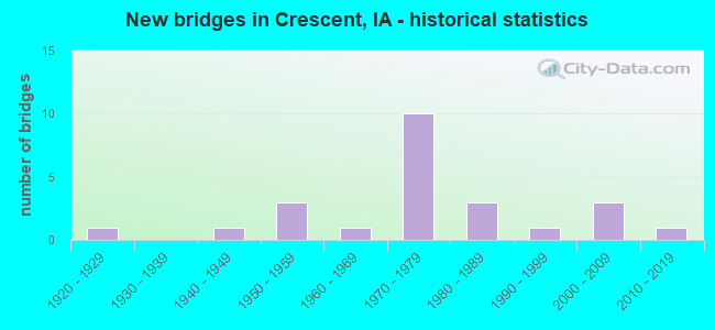
- New bridges - historical statistics
- 11920-1929
- 11940-1949
- 31950-1959
- 11960-1969
- 101970-1979
- 31980-1989
- 11990-1999
- 32000-2009
- 12010-2019
FCC Registered Antenna Towers:
38 (See the full list of FCC Registered Antenna Towers in Crescent)FCC Registered Broadcast Land Mobile Towers:
2- 1/16 Mi N Of (Lat: 41.367500 Lon: -95.886389), Call Sign: KNBP890, Licensee ID: L00394825,
Assigned Frequencies: 158.355 MHz, Grant Date: 09/26/2001, Expiration Date: 09/27/2011, Cancellation Date: 12/03/2011, Registrant: Arvin Eichstadt, 1613 Old Lincoln Hwy, Crescent, IA 51526, Phone: (712) 545-3602
- Lat: 41.354861 Lon: -95.893250, Call Sign: WQTL723,
Assigned Frequencies: 452.512 MHz, 451.312 MHz, 452.312 MHz, 457.312 MHz, 451.187 MHz, Grant Date: 02/28/2014, Expiration Date: 02/28/2024, Certifier: Roger Clark, Registrant: Communications Usa, Inc., 2229 Enterprise Street, Escondido, CA 92029, Phone: (800) 338-1949, Fax: (858) 674-4273, Email:
FCC Registered Microwave Towers:
4- SAPP BROTHERS - A, 15922 Limekiln Rd (Lat: 41.348611 Lon: -95.878889), Type: Tower, Structure height: 18.3 m, Overall height: 22.9 m, Call Sign: WQIX452,
Assigned Frequencies: 10755.0 MHz, Grant Date: 06/10/2008, Expiration Date: 06/10/2018, Cancellation Date: 12/10/2009, Certifier: William Chastain, Registrant: Radio Dynamics Corporation, Silver Spring, MD 20914, Phone: (301) 493-5171, Fax: (301) 576-4553, Email:
- CLARA, 22901 River Road North (Lat: 41.344778 Lon: -95.913750), Type: Gtower, Structure height: 53.3 m, Overall height: 54.3 m, Call Sign: WQMD730,
Assigned Frequencies: 6315.84 MHz, Grant Date: 06/02/2020, Expiration Date: 07/08/2030, Certifier: John E Rooney, Registrant: Wilkinson Barker Knauer, LLP, 1800 M Street Nw, Suite 800n, Washington, DC 20036, Phone: (202) 383-3420, Fax: (202) 783-5851, Email:
- OM03XC201, 15010 Rosewood Road (Lat: 41.422028 Lon: -95.898111), Type: Mtower, Structure height: 36.6 m, Call Sign: WQVU278,
Assigned Frequencies: 10895.0 MHz, 10895.0 MHz, 10895.0 MHz, 10895.0 MHz, 10895.0 MHz, 10895.0 MHz, 10895.0 MHz, 10935.0 MHz, 10935.0 MHz, 10935.0 MHz... (+4 more), Grant Date: 05/08/2015, Expiration Date: 05/08/2025, Certifier: David Werblow, Registrant: Dla Piper LLP, 500 8th Street, Nw, Washington, DC 20004, Phone: (202) 799-4216, Fax: (202) 799-5616, Email:
- ON01112A, 14594 Jet Lane (311148) (Lat: 41.359417 Lon: -95.905500), Type: Pole, Structure height: 46.3 m, Overall height: 47.5 m, Call Sign: WRFL452,
Assigned Frequencies: 11245.0 MHz, 11245.0 MHz, 11245.0 MHz, 11245.0 MHz, 11245.0 MHz, 11245.0 MHz, 11245.0 MHz, 11245.0 MHz, 11245.0 MHz, 11245.0 MHz... (+11 more), Grant Date: 03/24/2020, Expiration Date: 03/24/2030, Certifier: David Werblow, Registrant: T-Mobile Usa, Inc., 12920 Se 38th Street, Bellevue, WA 98006, Phone: (425) 383-8401, Fax: (425) 383-4040, Email:
FCC Registered Amateur Radio Licenses:
10 (See the full list of FCC Registered Amateur Radio Licenses in Crescent)FAA Registered Aircraft Manufacturers and Dealers:
2- SCHNACK KENNETH L, 26997 152nd St, Crescent, IA 51526
Certificate: D005575 (Individual), Certificate Issue Date: 12/30/2014, Expiration Date: 12/29/2015 - SCHNACK MARCUS J, 26997 152nd St, Crescent, IA 51526
Certificate: D006271 (Co-Ownership), Certificate Issue Date: 01/15/2020, Expiration Date: 01/14/2021
FAA Registered Aircraft:
5- Aircraft: CESSNA 182P (Category: Land, Seats: 4, Weight: Up to 12,499 Pounds, Speed: 120 mph), Engine: CONT MOTOR O-470 SERIES (230 HP) (Reciprocating)
N-Number: 124K, N124K, N-124K, Serial Number: 18263803, Year manufactured: 1975, Airworthiness Date: 04/17/1975, Certificate Issue Date: 03/28/2017
Registrant (LLC): Kelley Aviation LLC, 17751 Badger Ave, Crescent, IA 51526 - Aircraft: PIPER PA-22-135 (Category: Land, Seats: 4, Weight: Up to 12,499 Pounds, Speed: 94 mph), Engine: LYCOMING 0-290 SERIES (140 HP) (Reciprocating)
N-Number: 1270C, N1270C, N-1270C, Serial Number: 22-1063, Year manufactured: 1953, Certificate Issue Date: 02/08/2017
Registrant (Individual): Kenneth L Schnack, 26997 152nd St, Crescent, IA 51526 - Aircraft: BEECH C24R (Category: Land, Seats: 6, Weight: Up to 12,499 Pounds, Speed: 178 mph), Engine: LYCOMING I0360 SER A&C (200 HP) (Reciprocating)
N-Number: 6716T, N6716T, N-6716T, Serial Number: MC-716, Year manufactured: 1980, Airworthiness Date: 01/03/1980, Certificate Issue Date: 12/11/2015
Registrant (Co-Owned): Marcus J Schnack, 26997 152nd St, Crescent, IA 51526, Other Owners: Kenneth L Schnack - Aircraft: CESSNA 182P (Category: Land, Seats: 4, Weight: Up to 12,499 Pounds, Speed: 120 mph), Engine: CONT MOTOR O-470 SERIES (230 HP) (Reciprocating)
N-Number: 6693M, N6693M, N-6693M, Serial Number: 18263803, Year manufactured: 1975, Airworthiness Date: 04/17/1975, Certificate Issue Date: 03/28/2017
Registrant (Corporation): Kelley Aviation LLC, 17751 Badger Ave, Crescent, IA 51526 - Aircraft: AMERICAN AA-1 (Category: Land, Seats: 2, Weight: Up to 12,499 Pounds, Speed: 108 mph), Engine: LYCOMING 0-235 SERIES (115 HP) (Reciprocating)
N-Number: 5949L, N5949L, N-5949L, Serial Number: AA1-0249, Year manufactured: 1969, Airworthiness Date: 10/20/1969, Certificate Issue Date: 08/01/2011
Registrant (Co-Owned): Kenneth L Schnack, 26997 152nd St, Crescent, IA 51526, Other Owners: Jan C Schnack
Deregistered: Cancel Date: 11/14/2017
| Home Mortgage Disclosure Act Aggregated Statistics For Year 2009 (Based on 1 partial tract) | ||
| C) Refinancings | ||
|---|---|---|
| Number | Average Value | |
| LOANS ORIGINATED | 1 | $225,940 |
| APPLICATIONS APPROVED, NOT ACCEPTED | 0 | $0 |
| APPLICATIONS DENIED | 0 | $0 |
| APPLICATIONS WITHDRAWN | 0 | $0 |
| FILES CLOSED FOR INCOMPLETENESS | 0 | $0 |
Detailed HMDA statistics for the following Tracts: 0214.00
2002 - 2016 National Fire Incident Reporting System (NFIRS) incidents
- Fire incident types reported to NFIRS in Crescent, IA
- 9062.9%Outside Fires
- 2416.8%Structure Fires
- 2114.7%Mobile Property/Vehicle Fires
- 85.6%Other
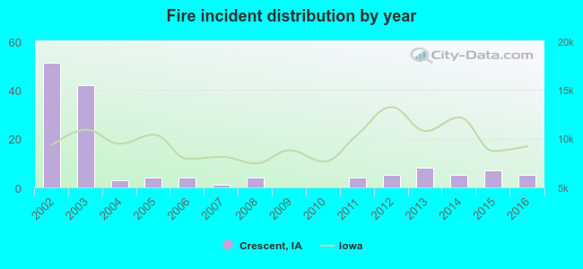 Based on the data from the years 2002 - 2016 the average number of fires per year is 10. The highest number of reported fire incidents - 51 took place in 2002, and the least - 0 in 2009. The data has a declining trend.
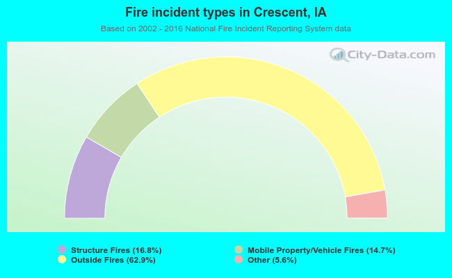 When looking into fire subcategories, the most incidents belonged to: Outside Fires (62.9%), and Structure Fires (16.8%).
| Most common first names in Crescent, IA among deceased individuals | ||
| Name | Count | Lived (average) |
|---|---|---|
| Robert | 16 | 71.8 years |
| John | 10 | 77.7 years |
| Charles | 6 | 80.7 years |
| Mary | 6 | 85.3 years |
| Donald | 4 | 68.7 years |
| Anna | 4 | 85.5 years |
| Helen | 4 | 74.8 years |
| Ruth | 4 | 82.0 years |
| Edward | 3 | 84.3 years |
| Fred | 3 | 66.6 years |
| Most common last names in Crescent, IA among deceased individuals | ||
| Last name | Count | Lived (average) |
|---|---|---|
| Thompson | 7 | 75.2 years |
| Clark | 6 | 79.7 years |
| Collins | 5 | 71.0 years |
| Miller | 5 | 74.6 years |
| Smith | 5 | 74.8 years |
| Anderson | 4 | 72.5 years |
| Brewer | 4 | 85.5 years |
| Mcintosh | 4 | 83.0 years |
| Arrick | 3 | 57.6 years |
| Hatcher | 3 | 74.3 years |
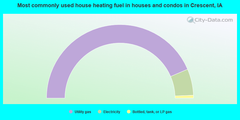
- 87.1%Utility gas
- 11.6%Electricity
- 1.2%Bottled, tank, or LP gas
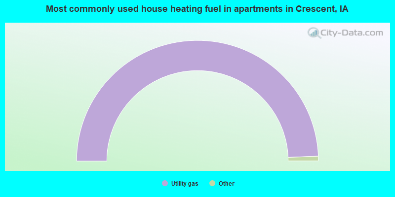
- 100.0%Utility gas
Crescent compared to Iowa state average:
- Unemployed percentage significantly below state average.
- Black race population percentage significantly below state average.
- Foreign-born population percentage significantly below state average.
- Renting percentage significantly below state average.
- Length of stay since moving in significantly above state average.
- House age below state average.