Crescent, Washington

Submit your own pictures of this place and show them to the world
- OSM Map
- General Map
- Google Map
- MSN Map

| Males: 1,695 | |
| Females: 1,677 |
| Median resident age: | 43.2 years |
| Washington median age: | 35.3 years |
Zip code: 98363
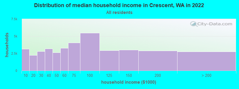
| Crescent: | $71,470 |
| WA: | $91,306 |
Estimated per capita income in 2022: $39,582 (it was $18,468 in 2000)
Crescent CCD income, earnings, and wages data
Estimated median house or condo value in 2022: $496,179 (it was $144,000 in 2000)
| Crescent: | $496,179 |
| WA: | $569,500 |
Mean prices in 2022: all housing units: $459,016; detached houses: $506,716; townhouses or other attached units: $497,618; in 2-unit structures: $248,005; in 3-to-4-unit structures: $251,324; in 5-or-more-unit structures: $440,931; mobile homes: $206,962; occupied boats, rvs, vans, etc.: $91,136
Detailed information about poverty and poor residents in Crescent, WA


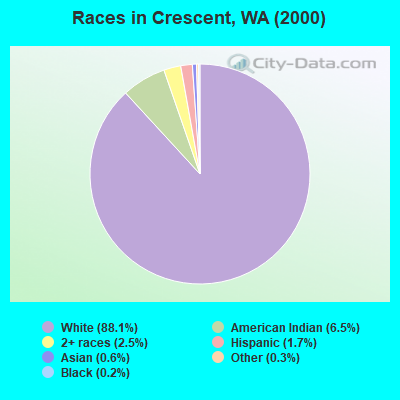
- 2,71888.1%White alone
- 1996.5%American Indian alone
- 762.5%Two or more races
- 531.7%Hispanic
- 200.6%Asian alone
- 100.3%Other race alone
- 70.2%Black alone
- 20.06%Native Hawaiian and Other
Pacific Islander alone
Races in Crescent detailed stats: ancestries, foreign born residents, place of birth
 Recent articles from our blog. Our writers, many of them Ph.D. graduates or candidates, create easy-to-read articles on a wide variety of topics.
Current Local Time: PST time zone
Land area: 411.8 square miles.
Population density: 8.2 people per square mile (very low).

| Crescent CCD: | 0.9% ($1,265) |
| Washington: | 1.2% ($1,915) |
Nearest city with pop. 50,000+: Shoreline, WA  (68.4 miles , pop. 53,025).
Nearest city with pop. 200,000+: Seattle, WA (72.3 miles , pop. 563,374).
Nearest city with pop. 1,000,000+: Los Angeles, CA (1007.1 miles , pop. 3,694,820).
Nearest cities:
), ), ), Latitude: 48.09 N, Longitude: 123.73 W
Area code commonly used in this area: 360

| Here: | 6.3% |
| Washington: | 4.6% |
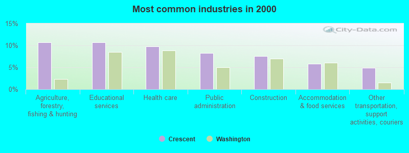
- Agriculture, forestry, fishing & hunting (10.7%)
- Educational services (10.7%)
- Health care (9.8%)
- Public administration (8.2%)
- Construction (7.5%)
- Accommodation & food services (5.8%)
- Other transportation, support activities, couriers (4.8%)
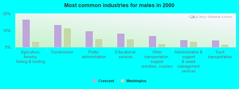
- Agriculture, forestry, fishing & hunting (16.6%)
- Construction (13.4%)
- Public administration (9.7%)
- Educational services (8.4%)
- Other transportation, support activities, couriers (6.9%)
- Administrative & support & waste management services (4.4%)
- Truck transportation (4.3%)
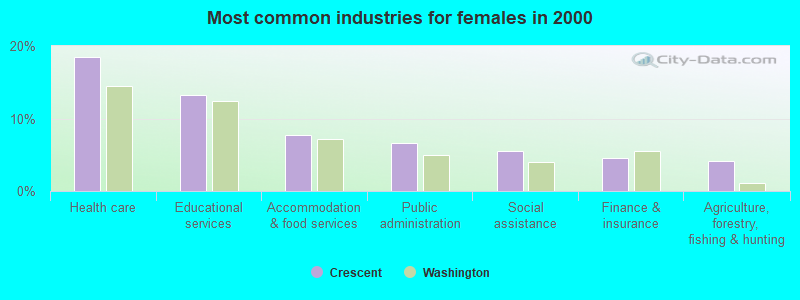
- Health care (18.5%)
- Educational services (13.2%)
- Accommodation & food services (7.7%)
- Public administration (6.6%)
- Social assistance (5.5%)
- Finance & insurance (4.5%)
- Agriculture, forestry, fishing & hunting (4.2%)
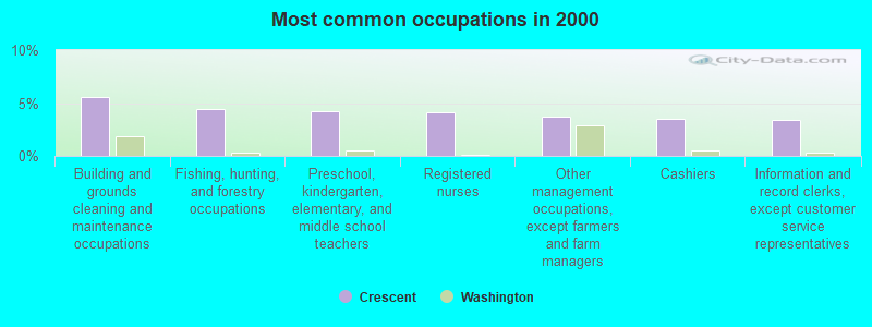
- Building and grounds cleaning and maintenance occupations (5.6%)
- Fishing, hunting, and forestry occupations (4.5%)
- Preschool, kindergarten, elementary, and middle school teachers (4.2%)
- Registered nurses (4.1%)
- Other management occupations, except farmers and farm managers (3.8%)
- Cashiers (3.5%)
- Information and record clerks, except customer service representatives (3.4%)
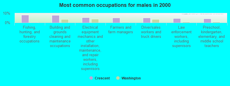
- Fishing, hunting, and forestry occupations (8.1%)
- Building and grounds cleaning and maintenance occupations (7.9%)
- Electrical equipment mechanics and other installation, maintenance, and repair workers, including supervisors (5.6%)
- Farmers and farm managers (5.1%)
- Driver/sales workers and truck drivers (5.1%)
- Law enforcement workers, including supervisors (4.6%)
- Preschool, kindergarten, elementary, and middle school teachers (4.3%)
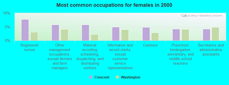
- Registered nurses (7.7%)
- Other management occupations, except farmers and farm managers (5.8%)
- Material recording, scheduling, dispatching, and distributing workers (5.8%)
- Information and record clerks, except customer service representatives (5.0%)
- Cashiers (4.8%)
- Preschool, kindergarten, elementary, and middle school teachers (4.2%)
- Secretaries and administrative assistants (4.2%)
Average climate in Crescent, Washington
Based on data reported by over 4,000 weather stations


(lower is better)
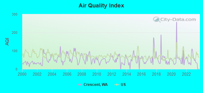
Air Quality Index (AQI) level in 2022 was 56.9. This is better than average.
| City: | 56.9 |
| U.S.: | 72.6 |
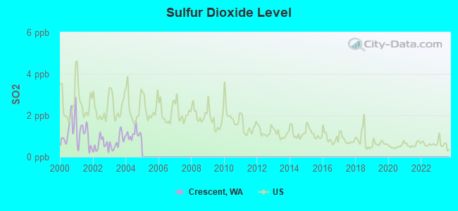
Sulfur Dioxide (SO2) [ppb] level in 2004 was 1.09. This is better than average. Closest monitor was 13.6 miles away from the city center.
| City: | 1.09 |
| U.S.: | 1.51 |
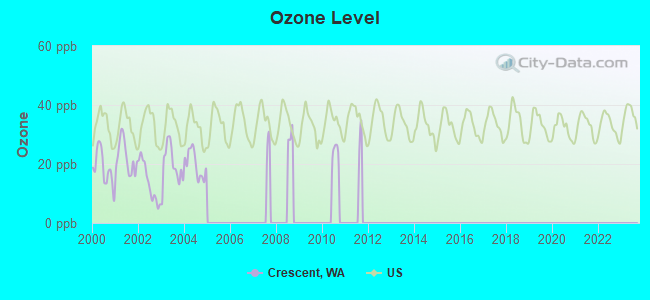
Ozone [ppb] level in 2004 was 19.9. This is significantly better than average. Closest monitor was 14.1 miles away from the city center.
| City: | 19.9 |
| U.S.: | 33.3 |
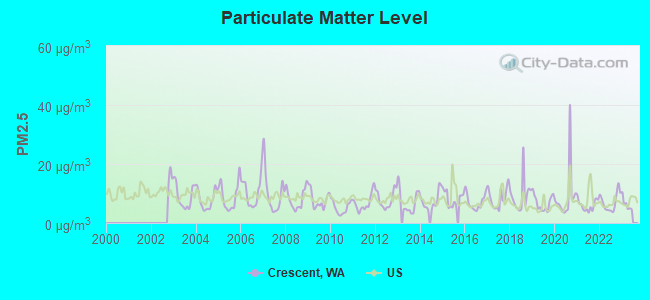
Particulate Matter (PM2.5) [µg/m3] level in 2022 was 7.07. This is about average. Closest monitor was 12.6 miles away from the city center.
| City: | 7.07 |
| U.S.: | 8.11 |
Earthquake activity:
Crescent-area historical earthquake activity is significantly above Washington state average. It is 1049% greater than the overall U.S. average.On 4/13/1949 at 19:55:42, a magnitude 7.0 (7.0 UK, Class: Major, Intensity: VIII - XII) earthquake occurred 81.4 miles away from the city center, causing $80,000,000 total damage
On 2/28/2001 at 18:54:32, a magnitude 6.8 (6.8 MD, Depth: 32.2 mi, Class: Strong, Intensity: VII - IX) earthquake occurred 79.9 miles away from the city center
On 2/28/2001 at 18:54:32, a magnitude 6.8 (6.5 MB, 6.6 MS, 6.8 MW) earthquake occurred 87.3 miles away from the city center, causing $2,000,000,000 total damage and $305,000,000 insured losses
On 4/29/1965 at 15:28:43, a magnitude 6.6 (6.6 UK) earthquake occurred 84.1 miles away from the city center, causing $28,000,000 total damage
On 7/3/1999 at 01:43:54, a magnitude 5.8 (5.4 MB, 5.5 MS, 5.8 MW, 5.3 ME, Depth: 25.2 mi, Class: Moderate, Intensity: VI - VII) earthquake occurred 74.6 miles away from the city center
On 5/3/1996 at 04:04:22, a magnitude 5.5 (5.2 MB, 5.3 MD, 5.5 ML, Depth: 2.5 mi) earthquake occurred 93.7 miles away from Crescent center
Magnitude types: body-wave magnitude (MB), duration magnitude (MD), energy magnitude (ME), local magnitude (ML), surface-wave magnitude (MS), moment magnitude (MW)
Natural disasters:
The number of natural disasters in Clallam County (21) is greater than the US average (15).Major Disasters (Presidential) Declared: 19
Emergencies Declared: 1
Causes of natural disasters: Floods: 14, Mudslides: 10, Storms: 10, Landslides: 9, Winter Storms: 7, Winds: 5, Tornadoes: 2, Earthquake: 1, Hurricane: 1, Snow: 1, Volcanic Eruption: 1, Other: 1 (Note: some incidents may be assigned to more than one category).
Hospitals and medical centers near Crescent:
Colleges/universities with over 2000 students nearest to Crescent:
- Peninsula College (about 15 miles; Port Angeles, WA; Full-time enrollment: 2,012)
- Olympic College (about 62 miles; Bremerton, WA; FT enrollment: 6,158)
- Edmonds Community College (about 68 miles; Lynnwood, WA; FT enrollment: 7,271)
- Shoreline Community College (about 68 miles; Shoreline, WA; FT enrollment: 5,026)
- Skagit Valley College (about 70 miles; Mount Vernon, WA; FT enrollment: 3,803)
- Seattle Community College-North Campus (about 71 miles; Seattle, WA; FT enrollment: 4,220)
- Seattle Pacific University (about 71 miles; Seattle, WA; FT enrollment: 3,897)
Points of interest:
Notable locations in Crescent: Flapjack Shelter (A), Soleduck Ranger Station (B), Sol Duc Hot Springs (C), Lyre River Campground (D), Canyon Creek Shelter (E), Calawah Shelter (F), Twentyone Mile Shelter (G), Boulder Lake Shelter (H), Bogachiel Shelter (I), Boulder Creek Campground (J), Salt Creek Campground (K), Freshwater Bay Boat Launch Ramp (L), Altair Campgrounds (M), Fairholme Ranger Station (N), Fairholme Campground (O), North Shore Picnic Area (P), La Poel Picnic Area (Q), Barnes Point Picnic Area (R), Lake Crescent Ranger Station (S), East Beach Picnic Area (T). Display/hide their locations on the map
Church in Crescent: Joyce Bible Church (A). Display/hide its location on the map
Lakes: Mink Lake (A), No Name Lake (B), Clear Lake (C), Haigs Lake (D), Sol Duc Lake (E), Deer Lake (F), Happy Lake (G), Lake Sutherland (H). Display/hide their locations on the map
Rivers and creeks: Barnes Creek (A), Bee Creek (B), Blackwood Creek (C), Boulder Creek (D), Boundary Creek (E), Brandeberry Creek (F), Bridge Creek (G), Brush Creek (H), Camp Creek (I). Display/hide their locations on the map
Park in Crescent: Salt Creek Recreation Area (1). Display/hide its location on the map
| This place: | 2.4 people |
| Washington: | 2.5 people |
| This place: | 70.1% |
| Whole state: | 64.4% |
| This place: | 6.9% |
| Whole state: | 7.7% |
Likely homosexual households (counted as self-reported same-sex unmarried-partner households)
- Lesbian couples: 0.2% of all households
- Gay men: 0.1% of all households
| This place: | 14.6% |
| Whole state: | 10.6% |
| This place: | 6.4% |
| Whole state: | 4.6% |
3 people in workers' group living quarters and job corps centers in 2010
9 people in other workers' dormitories in 2000
For population 15 years and over in Crescent:
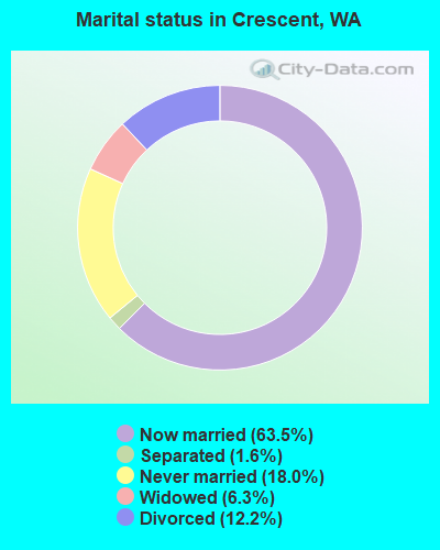
- Never married: 18.0%
- Now married: 63.5%
- Separated: 1.6%
- Widowed: 6.3%
- Divorced: 12.2%
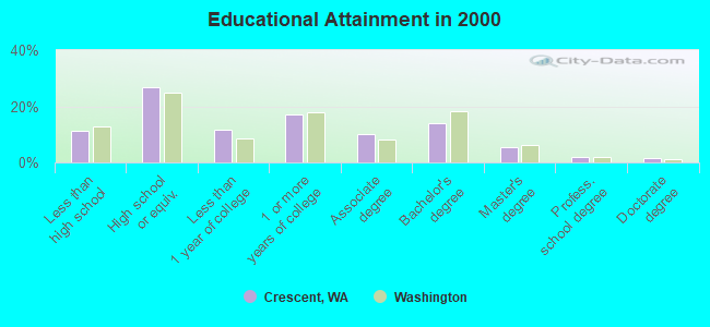
For population 25 years and over in Crescent:
- High school or higher: 88.7%
- Bachelor's degree or higher: 22.9%
- Graduate or professional degree: 9.0%
- Unemployed: 9.3%
- Mean travel time to work (commute): 30.7 minutes
| Here: | 9.9 |
| Washington average: | 11.3 |
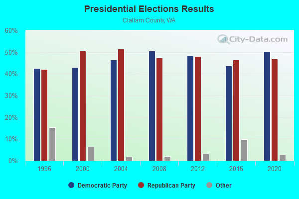
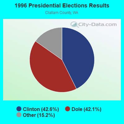
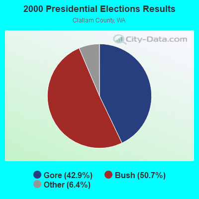
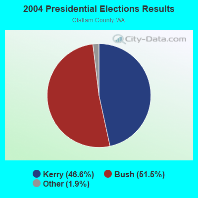
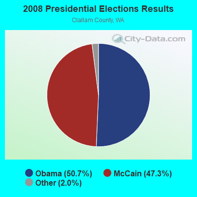
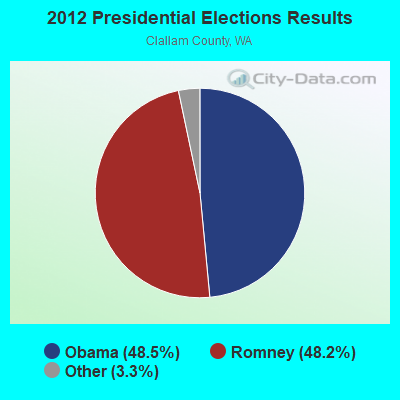
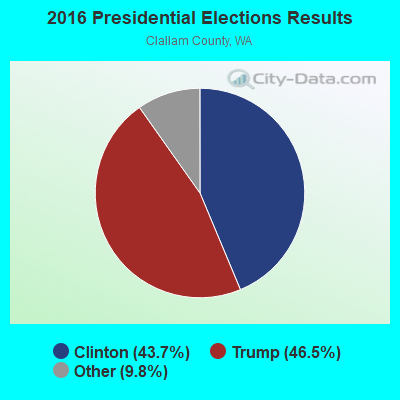

Graphs represent county-level data. Detailed 2008 Election Results
Religion statistics for Crescent, WA (based on Clallam County data)
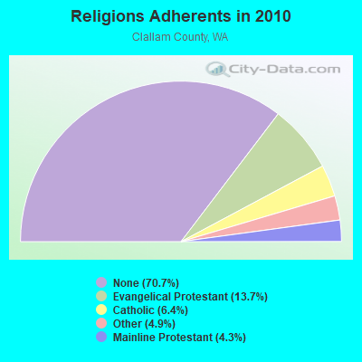
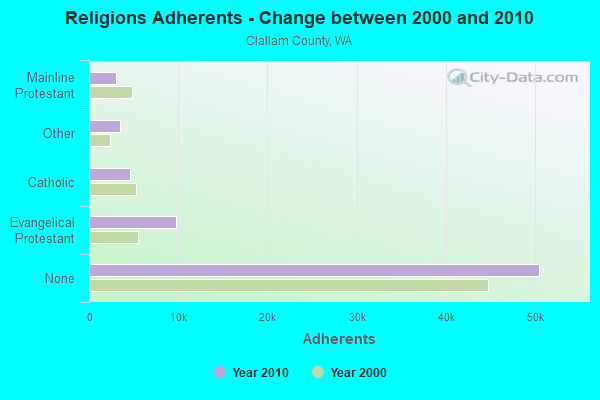
| Religion | Adherents | Congregations |
|---|---|---|
| Evangelical Protestant | 9,803 | 59 |
| Catholic | 4,581 | 4 |
| Other | 3,487 | 18 |
| Mainline Protestant | 3,035 | 13 |
| None | 50,498 | - |
Food Environment Statistics:
| This county: | 2.42 / 10,000 pop. |
| State: | 2.06 / 10,000 pop. |
| Clallam County: | 0.14 / 10,000 pop. |
| State: | 0.19 / 10,000 pop. |
| Clallam County: | 1.99 / 10,000 pop. |
| Washington: | 1.18 / 10,000 pop. |
| Clallam County: | 2.13 / 10,000 pop. |
| Washington: | 2.67 / 10,000 pop. |
| Clallam County: | 11.09 / 10,000 pop. |
| Washington: | 8.26 / 10,000 pop. |
| This county: | 8.9% |
| Washington: | 7.7% |
| Clallam County: | 26.6% |
| Washington: | 25.7% |
| Here: | 15.1% |
| Washington: | 13.9% |
Strongest AM radio stations in Crescent:
- KIRO (710 AM; 50 kW; SEATTLE, WA; Owner: ENTERCOM SEATTLE LICENSE, LLC)
- KGNW (820 AM; 50 kW; BURIEN-SEATTLE, WA; Owner: INSPIRATION MEDIA, INC.)
- KTTH (770 AM; 50 kW; SEATTLE, WA; Owner: ENTERCOM SEATTLE LICENSE, LLC)
- KKOL (1300 AM; 50 kW; SEATTLE, WA; Owner: INSPIRATION MEDIA, INC.)
- KOMO (1000 AM; 50 kW; SEATTLE, WA; Owner: FISHER BROADCASTING - SEATTLE RADIO, L.L.C.)
- KIXI (880 AM; 50 kW; MERCER ISLAND/SEATTL, WA; Owner: BELLEVUE RADIO, INC.)
- KYCW (1090 AM; 50 kW; SEATTLE, WA; Owner: INFINITY RADIO SUBSIDIARY OPERATIONS INC.)
- KARI (550 AM; 25 kW; BLAINE, WA; Owner: WAY BROADCASTING, INC.)
- KJR (950 AM; 50 kW; SEATTLE, WA)
- KRPI (1550 AM; 50 kW; FERNDALE, WA; Owner: BBC BROADCASTING, INC.)
- KRKO (1380 AM; 50 kW; EVERETT, WA; Owner: S-R BROADCASTING, CO.)
- KONP (1450 AM; 1 kW; PORT ANGELES, WA; Owner: RADIO PACIFIC, INC.)
- KIKN (1290 AM; 1 kW; PORT ANGELES, WA; Owner: COMMON GROUND BROADCASTING, INC.)
Strongest FM radio stations in Crescent:
- KNWP (90.1 FM; PORT ANGELES, WA; Owner: WASHINGTON STATE UNIVERSITY)
- KISM (92.9 FM; BELLINGHAM, WA; Owner: SAGA BROADCASTING, LLC)
- KWPZ (106.5 FM; LYNDEN, WA; Owner: CRISTA MINISTRIES, INC.)
- KAFE (104.3 FM; BELLINGHAM, WA; Owner: SAGA BROADCASTING, LLC)
- KAYO-FM (99.3 FM; ELMA, WA; Owner: SOUTH SOUND BROADCASTING, LLC)
TV broadcast stations around Crescent:
- K51HB (Channel 51; JOYCE, WA; Owner: CRESCENT TV RECEPTION IMPROVEMENT DISTRICT)
- K49CV (Channel 49; JOYCE, WA; Owner: CRESCENT TV RECEP. IMPROV. DIST.)
- K53CN (Channel 53; JOYCE, WA; Owner: CRESCENT TV RECEP. IMPROV. DIST.)
- K47BB (Channel 47; JOYCE, WA; Owner: CRESCENT TV RECEP. IMPROV. DIST.)
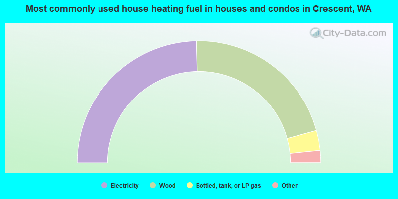
- 49.3%Electricity
- 42.2%Wood
- 5.3%Bottled, tank, or LP gas
- 1.8%Fuel oil, kerosene, etc.
- 1.1%Other fuel
- 0.3%Utility gas
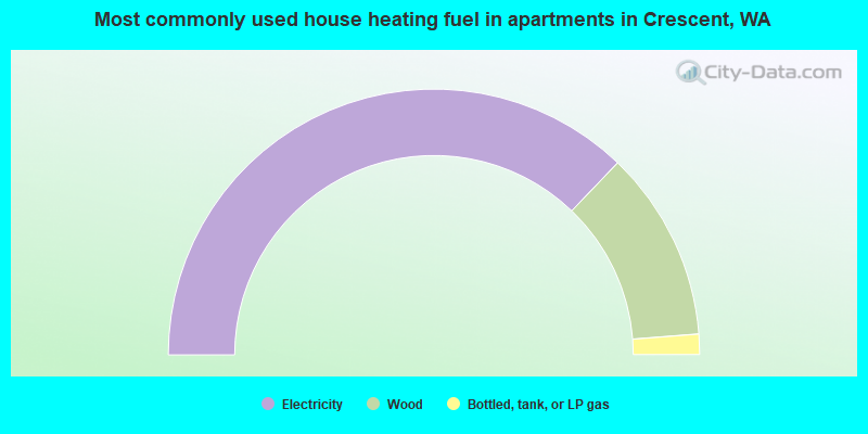
- 74.4%Electricity
- 23.2%Wood
- 2.5%Bottled, tank, or LP gas
Crescent compared to Washington state average:
- Black race population percentage significantly below state average.
- Hispanic race population percentage significantly below state average.
- Median age significantly above state average.
- Foreign-born population percentage significantly below state average.
- Renting percentage significantly below state average.
- Length of stay since moving in significantly above state average.
- Number of rooms per house significantly below state average.
- House age significantly below state average.
Crescent on our top lists:
- #90 on the list of "Top 101 cities with the largest percentage of people in other workers' dormitories (population 1,000+)"
- #14 on the list of "Top 101 counties with the lowest Sulfur Oxides Annual air pollution readings in 2012 (µg/m3)"
- #17 on the list of "Top 101 counties with the highest number of deaths per 1000 residents 2007-2013 (pop. 50,000+)"
- #23 on the list of "Top 101 counties with the lowest surface withdrawal of fresh water for public supply (pop. 50,000+)"
- #82 on the list of "Top 101 counties with the largest number of people moving in compared to moving out (pop. 50,000+)"
- #87 on the list of "Top 101 counties with highest percentage of residents voting for 3rd party candidates in the 2012 Presidential Election (pop. 50,000+)"