Estimated median house or condo value in 2022: $411,501 (it was $143,600 in 2000)
Damariscotta:
$411,501
ME:
$290,600
Mean prices in 2022:all housing units: $415,956; detached houses: $442,502; townhouses or other attached units: $442,441; in 2-unit structures: $393,150; in 3-to-4-unit structures: $266,359; in 5-or-more-unit structures: $407,319; mobile homes: $150,042; occupied boats, rvs, vans, etc.: $76,651March 2022 cost of living index in Damariscotta: 96.7 (near average, U.S. average is 100)
According to our research of Maine and other state lists, there were 5 registered sex offenders living in Damariscotta, Maine as of May 19, 2024. The ratio of all residents to sex offenders in Damariscotta is 444 to 1. The ratio of registered sex offenders to all residents in this city is near the state average.
Crime rates in Damariscotta by year
Type
2009
2010
2011
2012
2013
2014
2015
2016
2017
2018
2019
2020
2021
2022
Murders (per 100,000)
0 (0.0)
0 (0.0)
0 (0.0)
0 (0.0)
0 (0.0)
0 (0.0)
0 (0.0)
0 (0.0)
0 (0.0)
0 (0.0)
0 (0.0)
0 (0.0)
0 (0.0)
0 (0.0)
Rapes (per 100,000)
4 (210.5)
3 (135.3)
0 (0.0)
0 (0.0)
1 (45.4)
1 (45.3)
3 (135.5)
1 (45.2)
0 (0.0)
0 (0.0)
1 (46.5)
3 (139.9)
0 (0.0)
0 (0.0)
Robberies (per 100,000)
0 (0.0)
0 (0.0)
0 (0.0)
0 (0.0)
0 (0.0)
0 (0.0)
1 (45.2)
0 (0.0)
0 (0.0)
0 (0.0)
0 (0.0)
0 (0.0)
0 (0.0)
0 (0.0)
Assaults (per 100,000)
1 (52.6)
4 (180.3)
0 (0.0)
3 (136.0)
1 (45.4)
4 (181.2)
3 (135.5)
1 (45.2)
1 (46.2)
0 (0.0)
0 (0.0)
0 (0.0)
1 (46.4)
1 (42.9)
Burglaries (per 100,000)
9 (473.7)
12 (541.0)
9 (405.8)
3 (136.0)
1 (45.4)
8 (362.3)
11 (496.8)
3 (135.5)
5 (230.8)
1 (46.9)
1 (46.5)
5 (233.2)
1 (46.4)
3 (128.6)
Thefts (per 100,000)
34 (1,789)
45 (2,029)
48 (2,164)
35 (1,587)
32 (1,452)
68 (3,080)
34 (1,536)
39 (1,762)
59 (2,724)
41 (1,921)
44 (2,046)
33 (1,539)
20 (928.9)
14 (600.3)
Auto thefts (per 100,000)
0 (0.0)
0 (0.0)
0 (0.0)
0 (0.0)
0 (0.0)
0 (0.0)
0 (0.0)
0 (0.0)
0 (0.0)
2 (93.7)
1 (46.5)
1 (46.6)
2 (92.9)
0 (0.0)
Arson (per 100,000)
0 (0.0)
0 (0.0)
0 (0.0)
0 (0.0)
1 (45.4)
1 (45.3)
0 (0.0)
0 (0.0)
0 (0.0)
0 (0.0)
0 (0.0)
0 (0.0)
0 (0.0)
0 (0.0)
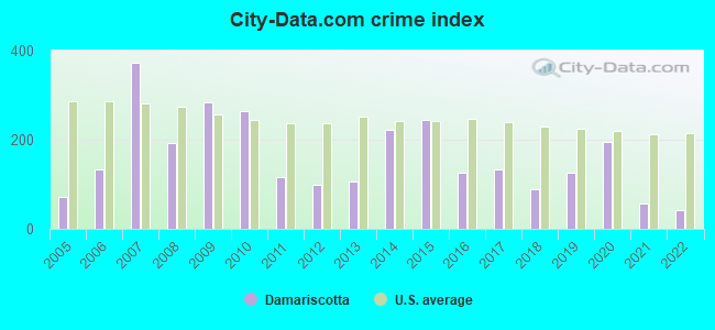
City-Data.com crime index
283.7
263.3
115.0
100.2
106.6
221.0
245.3
125.1
134.3
87.6
126.0
193.6
57.1
41.6
The City-Data.com crime index weighs serious crimes and violent crimes more heavily. Higher means more crime, U.S. average is 246.1. It adjusts for the number of visitors and daily workers commuting into cities.
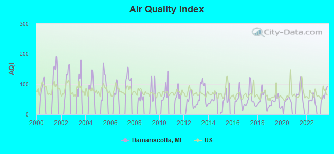
Air Quality Index (AQI) level in 2023 was 66.0. This is about average.
City:
66.0
U.S.:
72.6
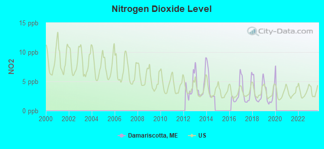
Nitrogen Dioxide (NO2) [ppb] level in 2019 was 2.80. This is significantly better than average.Closest monitor was 19.6 miles away from the city center.
City:
2.80
U.S.:
5.11
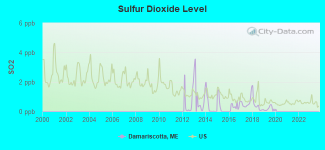
Sulfur Dioxide (SO2) [ppb] level in 2019 was 0.185. This is significantly better than average.Closest monitor was 8.6 miles away from the city center.
City:
0.185
U.S.:
1.515
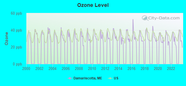
Ozone [ppb] level in 2023 was 30.7. This is about average.Closest monitor was 11.6 miles away from the city center.
City:
30.7
U.S.:
33.3
Earthquake activity:
Damariscotta-area historical earthquake activity is significantly above Maine state average. It is 77% smaller than the overall U.S. average.
On 10/16/2012 at 23:12:25, a magnitude 4.7 (4.7 ML, Depth: 10.0 mi, Class: Light, Intensity: IV - V) earthquake occurred 65.5 miles away from the city center On 4/20/2002 at 10:50:47, a magnitude 5.3 (5.3 ML, Depth: 3.0 mi, Class: Moderate, Intensity: VI - VII) earthquake occurred 210.7 miles away from the city center On 4/20/2002 at 10:50:47, a magnitude 5.2 (5.2 MB, 4.2 MS, 5.2 MW, 5.0 MW) earthquake occurred 211.5 miles away from Damariscotta center On 1/19/1982 at 00:14:42, a magnitude 4.7 (4.5 MB, 4.7 MD, 4.5 LG) earthquake occurred 111.6 miles away from Damariscotta center On 10/7/1983 at 10:18:46, a magnitude 5.3 (5.1 MB, 5.3 LG, 5.1 ML) earthquake occurred 241.3 miles away from the city center On 2/26/1999 at 03:38:43, a magnitude 3.8 (3.8 LG, Depth: 2.0 mi, Class: Light, Intensity: II - III) earthquake occurred 30.6 miles away from Damariscotta center Magnitude types: regional Lg-wave magnitude (LG), body-wave magnitude (MB), duration magnitude (MD), local magnitude (ML), surface-wave magnitude (MS), moment magnitude (MW)
Natural disasters:
The number of natural disasters in Lincoln County (24) is greater than the US average (15). Major Disasters (Presidential) Declared: 19 Emergencies Declared: 4
Causes of natural disasters: Floods: 15, Storms: 11, Winter Storms: 4, Hurricanes: 2, Snows: 2, Winds: 2, Blizzard: 1, Heavy Rain: 1, Ice Storm: 1, Landslide: 1, Snowfall: 1, Tropical Storm: 1, Other: 2 (Note: some incidents may be assigned to more than one category).
Main business address for: FIRST NATIONAL LINCOLN CORP /ME/ (NATIONAL COMMERCIAL BANKS).
Hospitals and medical centers in Damariscotta:
MILES HOME HEALTH HOSPICE DIVISION (40 BELVEDERE RD)
MILES MEMORIAL HOSPITAL INC (LINCOLN COUNTY HC) (Voluntary non-profit - Private, 35 MILES STREET)
COVE'S EDGE (26 SCHOONER STREET)
COVES EDGE ICF (BRISTOL RD)
DAMARISCOTTA DIALYSIS (4 EDWARD AVE)
MILES AND ST ANDREWS HOME HEALTH AND HOSPICE (40 BELVEDERE ROAD)
Colleges/universities with over 2000 students nearest to Damariscotta:
University of Maine at Augusta (about 26 miles; Augusta, ME; Full-time enrollment: 3,204)
Southern Maine Community College (about 46 miles; South Portland, ME; FT enrollment: 4,666)
University of Southern Maine (about 47 miles; Portland, ME; FT enrollment: 6,647)
Saint Joseph's College of Maine (about 52 miles; Standish, ME; FT enrollment: 2,010)
University of Maine at Farmington (about 55 miles; Farmington, ME; FT enrollment: 2,036)
University of New England (about 60 miles; Biddeford, ME; FT enrollment: 4,539)
Husson University (about 65 miles; Bangor, ME; FT enrollment: 2,421)
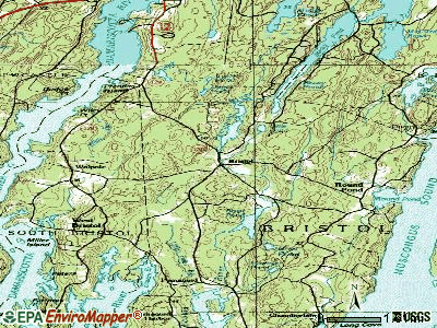
Notable locations in Damariscotta: Central Lincoln County Ambulance Service (A), American Legion Hall (B), Central Lincoln County YMCA Building (C), Chapman-Hall House Museum (D), Damariscotta Information Bureau (E), Damariscotta Region Chamber of Commerce (F), Lincoln Theatre (G), Damariscotta Fire Department Massasoit Engine Company (H), Skidompha Public Library (I). Display/hide their locations on the map
Birthplace of: Charles A. Boutelle - Politician, Anna Belknap - Actress, Glenn Chadbourne - Artist.
Lincoln County has a predicted average indoor radon screening level greater than 4 pCi/L (pico curies per liter) - Highest Potential
Drinking water stations with addresses in Damariscotta and their reported violations in the past:
GREAT SALT BAY SANITARY DIST (Population served: 1,900, Surface water):
Past health violations:
MCL, Average - Between JAN-2010 and MAR-2010, Contaminant: TTHM. Follow-up actions: St Public Notif requested (APR-16-2010), St Formal NOV issued (APR-16-2010), St Public Notif received (JUL-08-2010), St Compliance achieved (APR-14-2011)
MCL, Average - Between JAN-2010 and MAR-2010, Contaminant: Total Haloacetic Acids (HAA5). Follow-up actions: St Public Notif requested (APR-16-2010), St Formal NOV issued (APR-16-2010), St Public Notif received (JUL-08-2010), St Compliance achieved (APR-14-2011)
MCL, Average - Between OCT-2009 and DEC-2009, Contaminant: TTHM. Follow-up actions: St Public Notif requested (JAN-25-2010), St Formal NOV issued (JAN-25-2010), St Compliance achieved (APR-14-2011), St Intentional no-action (SEP-15-2011)
MCL, Average - Between OCT-2009 and DEC-2009, Contaminant: Total Haloacetic Acids (HAA5). Follow-up actions: St Public Notif requested (JAN-25-2010), St Formal NOV issued (JAN-25-2010), St Compliance achieved (APR-14-2011), St Intentional no-action (SEP-15-2011)
MCL, Average - Between JUL-2009 and SEP-2009, Contaminant: TTHM. Follow-up actions: St BCA signed (MAR-22-2007), St Public Notif requested (OCT-30-2009), St Formal NOV issued (OCT-30-2009), St Public Notif received (NOV-23-2009), St Compliance achieved (APR-14-2011)
MCL, Average - Between JUL-2009 and SEP-2009, Contaminant: Total Haloacetic Acids (HAA5). Follow-up actions: St BCA signed (MAR-22-2007), St Public Notif requested (OCT-30-2009), St Formal NOV issued (OCT-30-2009), St Public Notif received (NOV-23-2009), St Compliance achieved (APR-14-2011)
13 other older health violations
Past monitoring violations:
2 routine major monitoring violations
LAKE PEMAQUID CAMPGROUND (Address: 100 TWIN COVE LANE , Population served: 313, Groundwater):
Past monitoring violations:
2 routine major monitoring violations
AOS 93 BRISTOL CONSOLIDATED SCHOOL (Population served: 308, Groundwater):
Past monitoring violations:
Follow-up Or Routine LCR Tap M/R - In JUL-01-2009, Contaminant: Lead and Copper Rule. Follow-up actions: St Compliance achieved (SEP-18-2009), St Public Notif requested (DEC-30-2009), St Formal NOV issued (DEC-30-2009), St Public Notif received (JAN-07-2010)
AOS 93 NOBLEBORO CENTRAL SCHOOL (Population served: 233, Groundwater):
Past health violations:
MCL, Monthly (TCR) - In SEP-2011, Contaminant: Coliform. Follow-up actions: St Public Notif requested (OCT-11-2011), St Formal NOV issued (OCT-11-2011), St Public Notif received (OCT-18-2011), St Compliance achieved (OCT-24-2011)
REUNION STATION RESTAURANT (Population served: 216, Groundwater):
Past health violations:
MCL, Monthly (TCR) - In OCT-2012, Contaminant: Coliform. Follow-up actions: St Public Notif requested (OCT-19-2012), St Formal NOV issued (OCT-19-2012), St Compliance achieved (NOV-19-2012), St Public Notif received (JUN-25-2014), St Site Visit (enforcement) (JUN-25-2014)
MCL, Monthly (TCR) - In MAY-2014, Contaminant: Coliform. Follow-up actions: St Public Notif requested (JUN-03-2014), St Formal NOV issued (JUN-03-2014), St Compliance achieved (JUN-09-2014)
MCL, Monthly (TCR) - In OCT-2013, Contaminant: Coliform. Follow-up actions: St Public Notif requested (OCT-23-2013), St Formal NOV issued (OCT-23-2013), St Public Notif received (NOV-06-2013), St Compliance achieved (JUN-09-2014)
MCL, Monthly (TCR) - In OCT-2012, Contaminant: Coliform. Follow-up actions: St Public Notif requested (OCT-31-2012), St Formal NOV issued (OCT-31-2012), St Compliance achieved (JUN-03-2013)
Past monitoring violations:
4 routine major monitoring violations
4 regular monitoring violations
AOS 93 SOUTH BRISTOL ELEMENTARY SCHOOL (Population served: 73, Groundwater):
Past health violations:
MCL, Monthly (TCR) - In OCT-2012, Contaminant: Coliform. Follow-up actions: St Public Notif requested (OCT-26-2012), St Formal NOV issued (OCT-26-2012), St Compliance achieved (NOV-27-2012), St Public Notif received (JAN-02-2013)
MCL, Monthly (TCR) - In FEB-2008, Contaminant: Coliform. Follow-up actions: St Public Notif requested (FEB-22-2008), St Formal NOV issued (FEB-22-2008), St Public Notif received (FEB-27-2008), St Compliance achieved (SEP-07-2011)
MCL, Monthly (TCR) - In AUG-2006, Contaminant: Coliform. Follow-up actions: St Public Notif requested (AUG-23-2006), St Violation/Reminder Notice (AUG-23-2006), St Public Notif received (AUG-30-2006), St Compliance achieved (SEP-07-2011), St Intentional no-action (SEP-09-2011)
Past monitoring violations:
One routine major monitoring violation
One regular monitoring violation
ARROWSMITH BUILDING MILES HTH (Population served: 30, Groundwater):
Past health violations:
MCL, Monthly (TCR) - Between JAN-2012 and MAR-2012, Contaminant: Coliform. Follow-up actions: St Public Notif requested (APR-06-2012), St Formal NOV issued (APR-06-2012), St Public Notif received (APR-13-2012), St Compliance achieved (MAY-07-2012)
MCL, Monthly (TCR) - In JUN-2010, Contaminant: Coliform. Follow-up actions: St Public Notif requested (JUN-28-2010), St Formal NOV issued (JUN-28-2010), St Public Notif received (JUL-08-2010), St Compliance achieved (JUL-28-2010)
MCL, Monthly (TCR) - In MAY-2006, Contaminant: Coliform. Follow-up actions: St Public Notif requested (MAY-18-2006), St Violation/Reminder Notice (MAY-18-2006), St Public Notif received (JUN-02-2006), St Compliance achieved (SEP-07-2011), St Intentional no-action (SEP-09-2011)
MCL, Monthly (TCR) - In OCT-2005, Contaminant: Coliform. Follow-up actions: St Public Notif requested (OCT-28-2005), St Violation/Reminder Notice (OCT-28-2005), St Public Notif received (2 times from NOV-23-2005 to NOV-23-2005), St Compliance achieved (NOV-28-2005)
Average household size:
This town:
2.0 people
Maine:
2.3 people
Percentage of family households:
This town:
55.0%
Whole state:
62.9%
Percentage of households with unmarried partners:
This town:
7.7%
Whole state:
9.4%
Likely homosexual households (counted as self-reported same-sex unmarried-partner households)
Lesbian couples: 0.6% of all households
Gay men: 0.1% of all households
Residents with income below the poverty level in 2009:
This town:
11.7%
Whole state:
10.9%
Residents with income below 50% of the poverty level in 2009:
This town:
3.5%
Whole state:
4.1%
84 people in nursing facilities/skilled-nursing facilities in 2010
93 people in other noninstitutional group quarters in 2000
8 people in other group homes in 2000
Banks with branches in Damariscotta (2011 data):
Damariscotta Bank & Trust Co.: Damariscotta Branch at 619 Main Street, branch established on 2008/06/30; at 25 Main Street, branch established on 1973/01/22. Info updated 2007/04/24: Bank assets: $161.0 mil, Deposits: $142.6 mil, local headquarters, positive income, Commercial Lending Specialization, 6 total offices, Holding Company: Damariscotta Bankshares, Inc.
The First, N.A.: at 223 Main Street, branch established on 1864/04/19. Info updated 2010/06/01: Bank assets: $1,338.8 mil, Deposits: $942.2 mil, local headquarters, positive income, Commercial Lending Specialization, 14 total offices, Holding Company: First Bancorp, Inc., The
Bath Savings Institution: Damariscotta Branch at 8 Church Street, branch established on 1969/01/06. Info updated 2006/11/03: Bank assets: $636.7 mil, Deposits: $486.8 mil, headquarters in Bath, ME, positive income, Commercial Lending Specialization, 11 total offices
First Federal Savings and Loan Association of Bath: 238 Main Street Branch at 238 Main Street, branch established on 1935/01/01. Info updated 2011/11/28: Bank assets: $114.1 mil, Deposits: $94.9 mil, headquarters in Bath, ME, positive income, Mortgage Lending Specialization, 5 total offices
The Camden National Bank: Damariscotta Branch at 4 Coastal Market Drive, branch established on 1990/05/21. Info updated 2008/02/27: Bank assets: $2,266.8 mil, Deposits: $1,604.6 mil, headquarters in Camden, ME, positive income, Commercial Lending Specialization, 39 total offices, Holding Company: Camden National Corporation
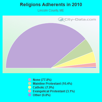
Religion statistics for Damariscotta, ME (based on Lincoln County data)
Religion
Adherents
Congregations
Mainline Protestant
3,586
29
Catholic
2,725
3
Evangelical Protestant
1,065
12
Other
279
4
None
26,802
-
Source: Clifford Grammich, Kirk Hadaway, Richard Houseal, Dale E.Jones, Alexei Krindatch, Richie Stanley and Richard H.Taylor. 2012. 2010 U.S.Religion Census: Religious Congregations & Membership Study. Association of Statisticians of American Religious Bodies. Jones, Dale E., et al. 2002. Congregations and Membership in the United States 2000. Nashville, TN: Glenmary Research Center. Graphs represent county-level data
Aircraft: CESSNA 182Q (Category: Land, Seats: 4, Weight: Up to 12,499 Pounds, Speed: 112 mph), Engine: CONT MOTOR O-470 SERIES (230 HP) (Reciprocating) N-Number: 97829, N97829, N-97829, Serial Number: 18267213, Year manufactured: 1979, Airworthiness Date: 08/25/1979, Certificate Issue Date: 01/04/2001 Registrant (Individual): James W Gallagher, Po Box 33, Damariscotta, ME 04543
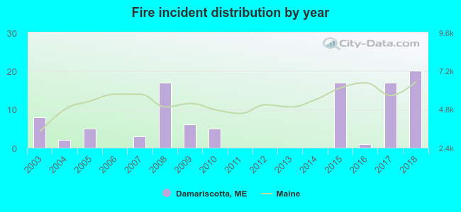
2003 - 2018 National Fire Incident Reporting System (NFIRS) incidents
According to the data from the years 2003 - 2018 the average number of fires per year is 6. The highest number of fire incidents - 20 took place in 2018, and the least - 0 in 2006. The data has a rising trend.
When looking into fire subcategories, the most incidents belonged to: Structure Fires (62.4%), and Outside Fires (22.8%).
Fire incident types reported to NFIRS in Damariscotta, ME


 Recent articles from our blog. Our writers, many of them Ph.D. graduates or candidates, create easy-to-read articles on a wide variety of topics.

 (46.5 miles


 According to the data from the years 2003 - 2018 the average number of fires per year is 6. The highest number of fire incidents - 20 took place in 2018, and the least - 0 in 2006. The data has a rising trend.
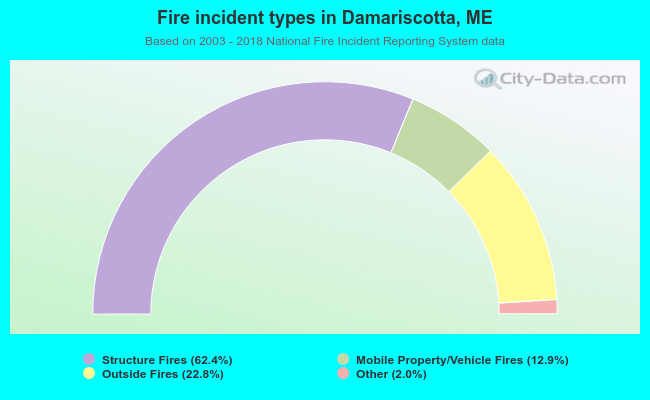 When looking into fire subcategories, the most incidents belonged to: Structure Fires (62.4%), and Outside Fires (22.8%).