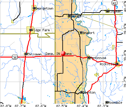
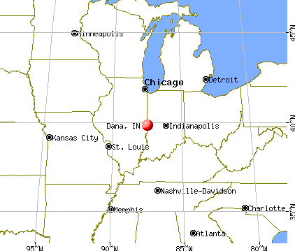
Dana, Indiana

Dana: Sunset - Dana, IN

Dana: Main Street (Maple Street)
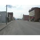
Dana: Main Steet
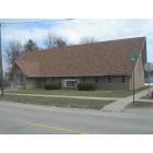
Dana: Community Bible Church
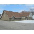
Dana: Community Bible Church

Dana: Main Steet

Dana: The Tracks
- add
your
Submit your own pictures of this town and show them to the world
- OSM Map
- General Map
- Google Map
- MSN Map
Population change since 2000: -16.6%
 |
| Males: 251 | |
| Females: 301 |
| Median resident age: | 37.0 years |
| Indiana median age: | 38.2 years |
Zip codes: 47847.
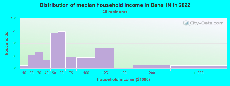
| Dana: | $50,134 |
| IN: | $66,785 |
Estimated per capita income in 2022: $29,339 (it was $15,603 in 2000)
Dana town income, earnings, and wages data
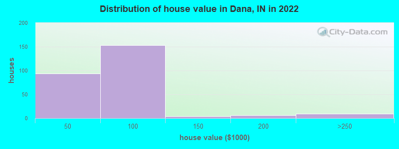
Estimated median house or condo value in 2022: $61,951 (it was $50,200 in 2000)
| Dana: | $61,951 |
| IN: | $208,700 |
Mean prices in 2022: all housing units: $64,395; detached houses: $74,958; mobile homes: $16,821
Median gross rent in 2022: $588.
Detailed information about poverty and poor residents in Dana, IN
Compare current foreclosures near Dana, IN:
| Photo | Address | Area | Beds / Baths | Price | Details |
|---|---|---|---|---|---|

|
#1
E 700 S
Dana, IN 47847
|
1,205 sq. feet
|
2 baths 3 beds |
show details | |

|
#2
S 300 W
Dana, IN 47847
|
- sq. feet
|
- baths - beds |
show details | |

|
#3
Sycamore St
Clinton, IN 47842
|
1,070 sq. feet
|
1 baths 2 beds |
$39,900
|
show details |

|
#4
S 4th St
Clinton, IN 47842
|
1,468 sq. feet
|
1 baths 3 beds |
$129,900
|
show details |

|
#5
S 3rd St
Clinton, IN 47842
|
806 sq. feet
|
1 baths 1 beds |
$37,900
|
show details |

|
#6
N Gilbert St
Clinton, IN 47842
|
1,632 sq. feet
|
1 baths 3 beds |
show details | |

|
#7
E Blackburn St
Paris, IL 61944
|
3,816 sq. feet
|
1 baths 5 beds |
show details | |

|
#8
Carlton Rd
West Terre Haute, IN 47885
|
1,704 sq. feet
|
2 baths 3 beds |
show details | |

|
#9
W 6th St
Rosedale, IN 47874
|
1,186 sq. feet
|
1 baths 3 beds |
show details | |

|
#10
Blackman St
Clinton, IN 47842
|
624 sq. feet
|
1 baths 2 beds |
show details |
| Photo | Address | Area | Beds / Baths | Price | Details |
|---|---|---|---|---|---|

|
#11
W Jonestown Rd
Clinton, IN 47842
|
1,620 sq. feet
|
2 baths 4 beds |
show details | |

|
#12
S 5th St
Clinton, IN 47842
|
2,004 sq. feet
|
1 baths 3 beds |
show details | |

|
#13
N Borman Pl
West Terre Haute, IN 47885
|
852 sq. feet
|
1 baths 2 beds |
show details | |

|
#14
N Virginia St
Rockville, IN 47872
|
768 sq. feet
|
1 baths 2 beds |
show details | |

|
#15
N 8th St
Clinton, IN 47842
|
1,024 sq. feet
|
1 baths 2 beds |
show details | |

|
#16
W Peabody Ln
Clinton, IN 47842
|
1,521 sq. feet
|
1 baths 2 beds |
show details | |

|
#17
N Virginia St
Rockville, IN 47872
|
1,391 sq. feet
|
1 baths 2 beds |
show details | |

|
#18
W Trinity Ave
Clinton, IN 47842
|
1,130 sq. feet
|
1 baths 2 beds |
show details | |

|
#19
N Ward Pl
West Terre Haute, IN 47885
|
1,530 sq. feet
|
1 baths 3 beds |
show details | |

|
#20
N 10th St
Clinton, IN 47842
|
884 sq. feet
|
1 baths 2 beds |
show details |
| Photo | Address | Area | Beds / Baths | Price | Details |
|---|---|---|---|---|---|

|
#21
S Us Highway 41
Rosedale, IN 47874
|
1,475 sq. feet
|
1 baths 3 beds |
show details | |

|
#22
Us Highway 150
West Terre Haute, IN 47885
|
2,216 sq. feet
|
1 baths 3 beds |
show details | |

|
#23
N 9th St
Clinton, IN 47842
|
1,464 sq. feet
|
1 baths 2 beds |
show details | |

|
#24
S Lincoln St
Clinton, IN 47842
|
882 sq. feet
|
1 baths 2 beds |
show details | |

|
#25
N Colorado St
Chrisman, IL 61924
|
- sq. feet
|
1 baths 2 beds |
show details | |

|
#26
S Mccord Ln
Rosedale, IN 47874
|
960 sq. feet
|
1 baths 3 beds |
show details | |

|
#27
Helen Ave
Paris, IL 61944
|
- sq. feet
|
2 baths 2 beds |
show details | |

|
#28
S Fulton St
Clinton, IN 47842
|
1,496 sq. feet
|
1 baths 3 beds |
show details | |

|
#29
N Plum St
Clinton, IN 47842
|
1,604 sq. feet
|
1 baths 3 beds |
show details | |

|
#30
S 6th St
Clinton, IN 47842
|
1,540 sq. feet
|
1 baths 1 beds |
show details |
| Photo | Address | Area | Beds / Baths | Price | Details |
|---|---|---|---|---|---|

|
#31
E N 3rd St Apt 4
Georgetown, IL 61846
|
- sq. feet
|
- baths - beds |
show details | |

|
#32
E 9th St
Georgetown, IL 61846
|
- sq. feet
|
- baths - beds |
show details | |

|
#33
N Jefferson St
Rockville, IN 47872
|
- sq. feet
|
- baths - beds |
show details | |

|
#34
S Michigan St
Rockville, IN 47872
|
- sq. feet
|
- baths - beds |
show details | |

|
#35
W Main St
Rockville, IN 47872
|
- sq. feet
|
- baths - beds |
show details | |

|
#36
W 9th St
Georgetown, IL 61846
|
- sq. feet
|
- baths - beds |
show details | |

|
#37
Buena Vista St
Rockville, IN 47872
|
- sq. feet
|
- baths - beds |
show details | |

|
#38
E Circle Dr
Rockville, IN 47872
|
- sq. feet
|
- baths - beds |
show details | |

|
#39
N Early Pl
West Terre Haute, IN 47885
|
- sq. feet
|
- baths - beds |
show details | |

|
#40
S 170 W
Kingman, IN 47952
|
- sq. feet
|
- baths - beds |
show details |
| Photo | Address | Area | Beds / Baths | Price | Details |
|---|---|---|---|---|---|

|
#41
Mill Rd
Georgetown, IL 61846
|
- sq. feet
|
- baths - beds |
show details | |

|
#42
S Carpenter Ave
Clinton, IN 47842
|
- sq. feet
|
- baths - beds |
show details | |

|
#43
N Bdale Rd
Bloomingdale, IN 47832
|
- sq. feet
|
- baths - beds |
show details | |

|
#44
N 6th St
Clinton, IN 47842
|
- sq. feet
|
- baths - beds |
show details | |

|
#45
S 3rd St
Cayuga, IN 47928
|
- sq. feet
|
- baths - beds |
show details | |

|
#46
S Rd 71 St
Blanford, IN 47831
|
- sq. feet
|
- baths - beds |
show details | |

|
#47
N Eugene Ave
Cayuga, IN 47928
|
- sq. feet
|
- baths - beds |
show details | |

|
#48
E 7th St
Clinton, IN 47842
|
- sq. feet
|
- baths - beds |
show details | |

|
#49
W College St
Mecca, IN 47860
|
- sq. feet
|
- baths - beds |
show details | |

|
Check over 1 million property listings on Foreclosure.com!
|
browse all offers | |||


- 63993.7%White alone
- 385.6%Two or more races
- 20.3%American Indian alone
- 10.1%Hispanic
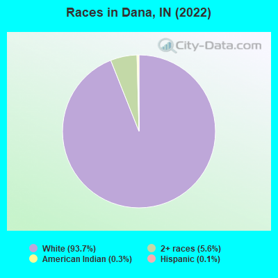
Races in Dana detailed stats: ancestries, foreign born residents, place of birth
 Recent articles from our blog. Our writers, many of them Ph.D. graduates or candidates, create easy-to-read articles on a wide variety of topics.

 | 93.1 wibc dropping rush limbaugh?? (35 replies) |
| Investing in Richmond old houses (13 replies) |
| Help!! Need motivation to make the move to Bloomington. (54 replies) |
| Advice on Buying a House in Historic West Central Neighborhood of Fort Wayne? (6 replies) |
| Marion, Indiana...Info Please! (64 replies) |
| Bloomington Apt to Rent/Might need room-mate (2 replies) |
Latest news from Dana, IN collected exclusively by city-data.com from local newspapers, TV, and radio stations
Ancestries: German (27.4%), American (18.5%), English (12.7%), Italian (6.9%), Norwegian (3.5%), Scottish (3.5%).
Current Local Time: EST time zone
Elevation: 637 feet
Land area: 0.29 square miles.
Population density: 1,881 people per square mile (low).
17 residents are foreign born (2.6% Latin America).
| This town: | 2.6% |
| Indiana: | 3.1% |
Median real estate property taxes paid for housing units with mortgages in 2022: $562 (0.9%)
Median real estate property taxes paid for housing units with no mortgage in 2022: $364 (0.7%)
Nearest city with pop. 50,000+: Terre Haute, IN  (24.0 miles , pop. 59,614).
Nearest city with pop. 200,000+: Indianapolis, IN (71.6 miles , pop. 781,870).
Nearest city with pop. 1,000,000+: Chicago, IL (141.0 miles , pop. 2,896,016).
Nearest cities:
), ), ), ), ), Latitude: 39.81 N, Longitude: 87.49 W
Area code: 765

Single-family new house construction building permits:
- 2001: 9 buildings, average cost: $89,700
- 2000: 9 buildings, average cost: $89,700
- 1999: 9 buildings, average cost: $89,700
- 1998: 9 buildings, average cost: $89,700
- 1997: 8 buildings, average cost: $89,700
| Here: | 3.6% |
| Indiana: | 2.8% |
- Construction (12.2%)
- Chemicals (7.4%)
- Health care (5.9%)
- Agriculture, forestry, fishing & hunting (4.8%)
- Accommodation & food services (4.8%)
- Plastics & rubber products (4.8%)
- Food & beverage stores (4.8%)
- Construction (16.6%)
- Chemicals (8.9%)
- Agriculture, forestry, fishing & hunting (7.1%)
- Food & beverage stores (5.3%)
- Educational services (5.3%)
- Administrative & support & waste management services (5.3%)
- Metal & metal products (5.3%)
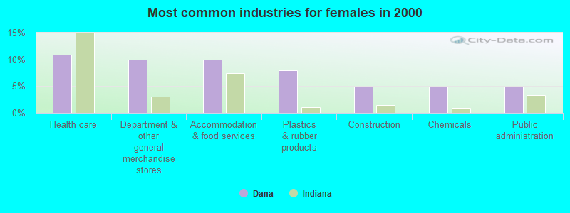
- Health care (10.9%)
- Department & other general merchandise stores (9.9%)
- Accommodation & food services (9.9%)
- Plastics & rubber products (7.9%)
- Construction (5.0%)
- Chemicals (5.0%)
- Public administration (5.0%)
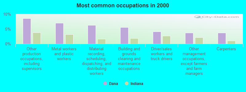
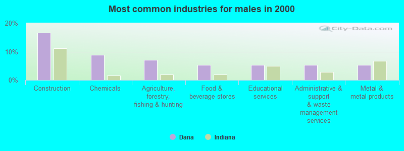
- Other production occupations, including supervisors (8.5%)
- Metal workers and plastic workers (7.0%)
- Material recording, scheduling, dispatching, and distributing workers (6.3%)
- Building and grounds cleaning and maintenance occupations (5.6%)
- Driver/sales workers and truck drivers (4.1%)
- Other management occupations, except farmers and farm managers (3.7%)
- Carpenters (3.7%)
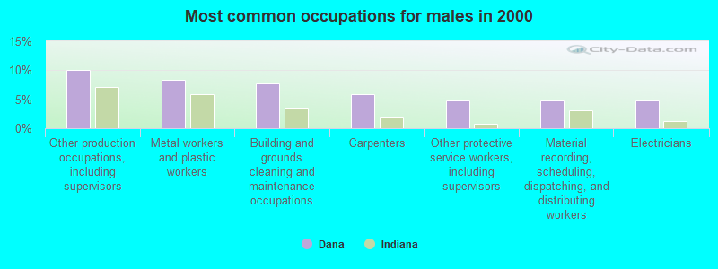
- Other production occupations, including supervisors (10.1%)
- Metal workers and plastic workers (8.3%)
- Building and grounds cleaning and maintenance occupations (7.7%)
- Carpenters (5.9%)
- Other protective service workers, including supervisors (4.7%)
- Material recording, scheduling, dispatching, and distributing workers (4.7%)
- Electricians (4.7%)

- Secretaries and administrative assistants (8.9%)
- Material recording, scheduling, dispatching, and distributing workers (8.9%)
- Other management occupations, except farmers and farm managers (7.9%)
- Cashiers (6.9%)
- Other production occupations, including supervisors (5.9%)
- Registered nurses (5.0%)
- Metal workers and plastic workers (5.0%)
Average climate in Dana, Indiana
Based on data reported by over 4,000 weather stations


(lower is better)
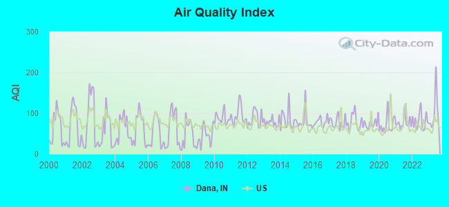
Air Quality Index (AQI) level in 2023 was 100. This is worse than average.
| City: | 100 |
| U.S.: | 73 |
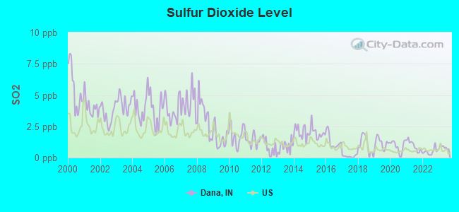
Sulfur Dioxide (SO2) [ppb] level in 2023 was 0.819. This is significantly better than average. Closest monitor was 21.1 miles away from the city center.
| City: | 0.819 |
| U.S.: | 1.515 |
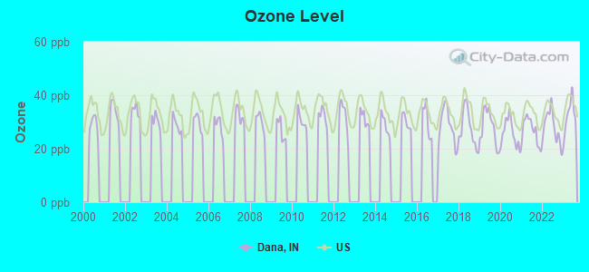
Ozone [ppb] level in 2023 was 32.2. This is about average. Closest monitor was 19.7 miles away from the city center.
| City: | 32.2 |
| U.S.: | 33.3 |
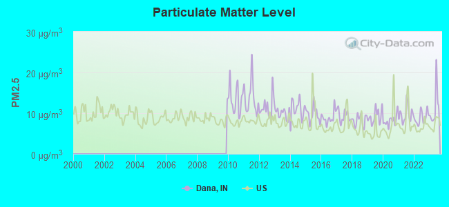
Particulate Matter (PM2.5) [µg/m3] level in 2023 was 11.4. This is worse than average. Closest monitor was 22.7 miles away from the city center.
| City: | 11.4 |
| U.S.: | 8.1 |
Tornado activity:
Dana-area historical tornado activity is near Indiana state average. It is 77% greater than the overall U.S. average.
On 4/22/1963, a category F3 (max. wind speeds 158-206 mph) tornado 0.6 miles away from the Dana town center injured 40 people and caused between $5000 and $50,000 in damages.
On 3/20/1976, a category F4 (max. wind speeds 207-260 mph) tornado 28.9 miles away from the town center injured 18 people and caused between $500,000 and $5,000,000 in damages.
Earthquake activity:
Dana-area historical earthquake activity is significantly above Indiana state average. It is 126% greater than the overall U.S. average.On 4/18/2008 at 09:36:59, a magnitude 5.4 (5.1 MB, 4.8 MS, 5.4 MW, 5.2 MW, Class: Moderate, Intensity: VI - VII) earthquake occurred 96.0 miles away from the city center
On 6/10/1987 at 23:48:54, a magnitude 5.1 (4.9 MB, 4.4 MS, 4.6 MS, 5.1 LG) earthquake occurred 71.3 miles away from the city center
On 4/18/2008 at 09:36:59, a magnitude 5.2 (5.2 MW, Depth: 8.9 mi) earthquake occurred 96.1 miles away from the city center
On 6/18/2002 at 17:37:15, a magnitude 5.0 (4.3 MB, 4.6 MW, 5.0 LG) earthquake occurred 126.8 miles away from Dana center
On 4/18/2008 at 15:14:16, a magnitude 4.8 (4.5 MB, 4.8 MW, 4.6 MW, Class: Light, Intensity: IV - V) earthquake occurred 94.0 miles away from the city center
On 4/3/1974 at 23:05:02, a magnitude 4.7 (4.5 MB, 4.7 LG) earthquake occurred 90.0 miles away from Dana center
Magnitude types: regional Lg-wave magnitude (LG), body-wave magnitude (MB), surface-wave magnitude (MS), moment magnitude (MW)
Natural disasters:
The number of natural disasters in Vermillion County (14) is near the US average (15).Major Disasters (Presidential) Declared: 9
Emergencies Declared: 3
Causes of natural disasters: Floods: 10, Storms: 8, Tornadoes: 4, Winter Storms: 2, Hurricane: 1, Snow: 1, Wind: 1, Other: 1 (Note: some incidents may be assigned to more than one category).

Hospitals and medical centers near Dana:
- CLINTON GARDENS (Nursing Home, about 12 miles away; CLINTON, IN)
- CHILD ADULT RESOURCE SRV INC (Hospital, about 12 miles away; CLINTON, IN)
- CLINTON NURSING HOME (Nursing Home, about 12 miles away; CLINTON, IN)
- WALNUT CREEK AT CLINTON (Nursing Home, about 12 miles away; CLINTON, IN)
- UNION HOSPITAL CLINTON Critical Access Hospitals (about 12 miles away; CLINTON, IN)
- VERMILLION CONVALESCENT CENTER (Nursing Home, about 13 miles away; CLINTON, IN)
- CHILD ADULT RESOURCES SRV INC (Hospital, about 16 miles away; KINGMAN, IN)
Colleges/universities with over 2000 students nearest to Dana:
- Danville Area Community College (about 23 miles; Danville, IL; Full-time enrollment: 2,229)
- Indiana State University (about 24 miles; Terre Haute, IN; FT enrollment: 10,925)
- Rose-Hulman Institute of Technology (about 25 miles; Terre Haute, IN; FT enrollment: 2,123)
- DePauw University (about 36 miles; Greencastle, IN; FT enrollment: 2,360)
- Eastern Illinois University (about 43 miles; Charleston, IL; FT enrollment: 9,414)
- University of Illinois at Urbana-Champaign (about 45 miles; Champaign, IL; FT enrollment: 47,528)
- Parkland College (about 48 miles; Champaign, IL; FT enrollment: 7,326)
Points of interest:
Notable location: Dana Community Volunteer Fire Department (A). Display/hide its location on the map
Tourist attraction: Ernie Pyle State Historic Site (Museums; 107 South Maple Street).
Drinking water stations with addresses in Dana and their reported violations in the past:
DANA WATER WORKS (Population served: 800, Groundwater):Past monitoring violations:
- Follow-up Or Routine LCR Tap M/R - In JUL-01-2008, Contaminant: Lead and Copper Rule. Follow-up actions: St Public Notif requested (JUL-29-2008), St Violation/Reminder Notice (JUL-29-2008), St Public Notif received (AUG-08-2008), St Compliance achieved (AUG-12-2008)
- One routine major monitoring violation
| This town: | 2.5 people |
| Indiana: | 2.5 people |
| This town: | 71.8% |
| Whole state: | 66.9% |
| This town: | 5.4% |
| Whole state: | 6.9% |
No gay or lesbian households reported
Banks with branches in Dana (2011 data):
- Bank of Indiana, National Association: Bank Of Indiana, National Association at 129 Maple Street, branch established on 1901/01/01. Info updated 2008/01/08: Bank assets: $108.4 mil, Deposits: $97.8 mil, local headquarters, negative income in the last year, Commercial Lending Specialization, 4 total offices, Holding Company: Indiana Bank Corp.
For population 15 years and over in Dana:
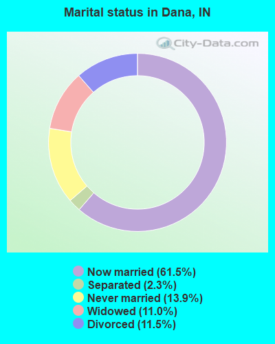
- Never married: 13.9%
- Now married: 61.5%
- Separated: 2.3%
- Widowed: 11.0%
- Divorced: 11.5%
For population 25 years and over in Dana:
- High school or higher: 92.8%
- Bachelor's degree or higher: 6.6%
- Graduate or professional degree: 1.0%
- Unemployed: 1.5%
- Mean travel time to work (commute): 21.4 minutes
| Here: | 5.9 |
| Indiana average: | 11.3 |
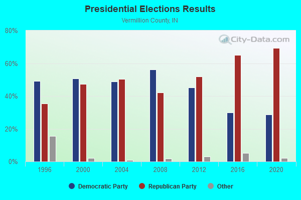
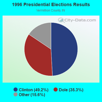


Graphs represent county-level data. Detailed 2008 Election Results
Religion statistics for Dana, IN (based on Vermillion County data)
| Religion | Adherents | Congregations |
|---|---|---|
| Evangelical Protestant | 2,462 | 18 |
| Mainline Protestant | 2,095 | 16 |
| Catholic | 1,010 | 2 |
| Other | 574 | 2 |
| None | 10,071 | - |
Food Environment Statistics:
| This county: | 2.44 / 10,000 pop. |
| Indiana: | 1.73 / 10,000 pop. |
| This county: | 6.72 / 10,000 pop. |
| Indiana: | 3.57 / 10,000 pop. |
| This county: | 6.72 / 10,000 pop. |
| State: | 6.78 / 10,000 pop. |
| This county: | 9.8% |
| State: | 9.2% |
| This county: | 30.5% |
| State: | 29.0% |
| Here: | 14.1% |
| Indiana: | 14.3% |
Health and Nutrition:
| This city: | 49.8% |
| State: | 49.3% |
| Dana: | 46.1% |
| Indiana: | 46.2% |
| Dana: | 28.7 |
| Indiana: | 28.7 |
| Dana: | 23.8% |
| Indiana: | 21.3% |
| Dana: | 6.0% |
| State: | 10.6% |
| Dana: | 6.8 |
| State: | 6.8 |
| Dana: | 32.4% |
| State: | 33.9% |
| Dana: | 57.7% |
| Indiana: | 56.1% |
| Dana: | 76.3% |
| Indiana: | 78.7% |
More about Health and Nutrition of Dana, IN Residents
| Local government employment and payroll (March 2022) | |||||
| Function | Full-time employees | Monthly full-time payroll | Average yearly full-time wage | Part-time employees | Monthly part-time payroll |
|---|---|---|---|---|---|
| Streets and Highways | 1 | $2,606 | $31,272 | 0 | $0 |
| Financial Administration | 1 | $3,287 | $39,444 | 1 | $1,053 |
| Water Supply | 0 | $0 | 1 | $1,644 | |
| Police Protection - Officers | 0 | $0 | 1 | $2,259 | |
| Totals for Government | 2 | $5,893 | $35,358 | 3 | $4,956 |
Dana government finances - Expenditure in 2017 (per resident):
- Current Operations - Police Protection: $20,000 ($36.23)
General Public Buildings: $12,000 ($21.74)
Financial Administration: $8,000 ($14.49)
Local Fire Protection: $4,000 ($7.25)
Parks and Recreation: $2,000 ($3.62)
- General - Interest on Debt: $86,000 ($155.80)
- Total Salaries and Wages: $25,000 ($45.29)
Dana government finances - Revenue in 2017 (per resident):
- State Intergovernmental - Highways: $22,000 ($39.86)
- Tax - Property: $68,000 ($123.19)
Motor Vehicle License: $4,000 ($7.25)
Dana government finances - Debt in 2017 (per resident):
- Long Term Debt - Beginning Outstanding - Unspecified Public Purpose: $2,158,000 ($3909.42)
Outstanding Unspecified Public Purpose: $2,129,000 ($3856.88)
Retired Unspecified Public Purpose: $29,000 ($52.54)
Dana government finances - Cash and Securities in 2017 (per resident):
- Other Funds - Cash and Securities: $161,000 ($291.67)
Strongest AM radio stations in Dana:
- WIBC (1070 AM; 50 kW; INDIANAPOLIS, IN; Owner: EMMIS RADIO LICENSE CORPORATION)
- WPFR (1480 AM; 5 kW; TERRE HAUTE, IN)
- WILL (580 AM; 5 kW; URBANA, IL; Owner: UNIV. OF ILLINOIS BOARD OF TRUSTEES)
- WLS (890 AM; 50 kW; CHICAGO, IL; Owner: WLS, INC.)
- WSCR (670 AM; 50 kW; CHICAGO, IL; Owner: INFINITY BROADCASTING OPERATIONS, INC.)
- WYLL (1160 AM; 50 kW; CHICAGO, IL; Owner: SCA LICENSE CORPORATION)
- WGN (720 AM; 50 kW; CHICAGO, IL; Owner: WGN CONTINENTAL BROADCASTING CO.)
- WBBM (780 AM; 50 kW; CHICAGO, IL; Owner: INFINITY BROADCASTING OPERATIONS, INC.)
- WMVP (1000 AM; 50 kW; CHICAGO, IL; Owner: ABC, INC.)
- WITY (980 AM; 1 kW; DANVILLE, IL; Owner: VERMILION BROADCASTING CORPORATION)
- WHAS (840 AM; 50 kW; LOUISVILLE, KY; Owner: CLEAR CHANNEL BROADCASTING LICENSES, INC.)
- WLW (700 AM; 50 kW; CINCINNATI, OH; Owner: JACOR BROADCASTING CORPORATION)
- WBAA (920 AM; 5 kW; WEST LAFAYETTE, IN; Owner: PURDUE UNIVERSITY)
Strongest FM radio stations in Dana:
- WAXI (104.9 FM; ROCKVILLE, IN; Owner: CROSSROADS INVESTMENTS, LLC)
- WPFR-FM (93.9 FM; CLINTON, IN; Owner: WORD POWER, INC.)
- WACF (98.5 FM; PARIS, IL; Owner: P.R.S. BROADCASTING, INC.)
- WISU (89.7 FM; TERRE HAUTE, IN; Owner: INDIANA STATE UNIV. BD. OF TRUSTEES)
- WMGI (100.7 FM; TERRE HAUTE, IN; Owner: BRIGHT TOWER COMMUNICATIONS, INC.)
- WTHI-FM (99.9 FM; TERRE HAUTE, IN; Owner: EMMIS RADIO LICENSE CORPORATION)
- WWSY (95.9 FM; SEELYVILLE, IN; Owner: BRIGHT TOWER COMMUNICATIONS, INC.)
- WBOW-FM (102.7 FM; TERRE HAUTE, IN; Owner: CROSSROADS INVESTMENTS, LLC)
- WGNJ (89.3 FM; ST. JOSEPH, IL; Owner: GOOD NEWS RADIO, INC.)
- WMHD-FM (90.7 FM; TERRE HAUTE, IN; Owner: ROSE-HULMAN INSTITUTE OF TECHNOLOGY)
- WXLS (99.1 FM; DANVILLE, IL; Owner: I.A.I. BROADCASTING, INC.)
- WCRT (88.5 FM; TERRE HAUTE, IN; Owner: ILLINOIS BIBLE INSTITUTE)
- WDNL (102.1 FM; DANVILLE, IL; Owner: NEUHOFF BROADCASTING - DANVILLE, INC)
- WKZS (103.1 FM; COVINGTON, IN; Owner: BENTON-WEATHERFORD BROADCASTING , INC., OF IN.)
TV broadcast stations around Dana:
- WICD (Channel 15; CHAMPAIGN, IL; Owner: WICD LICENSEE, LLC)
- W43BV (Channel 43; TERRE HAUTE, IN; Owner: TRINITY BROADCASTING NETWORK)
- WCIA (Channel 3; CHAMPAIGN, IL; Owner: NEXSTAR BROADCASTING OF CHAMPAIGN, L.L.C.)
- WTWO (Channel 2; TERRE HAUTE, IN; Owner: NEXSTAR BROADCASTING OF THE MIDWEST, INC.)
- WBAK-TV (Channel 38; TERRE HAUTE, IN; Owner: INDIANA BROADCASTING PARTNERS)
- WTHI-TV (Channel 10; TERRE HAUTE, IN; Owner: EMMIS TELEVISION LICENSE CORPORATION)
Dana fatal accident list:
Aug 21, 2017 07:35 AM, Us-36e, Lat: 39.793747, Lon: -87.409567, Vehicles: 1, Persons: 1, Fatalities: 1
Apr 4, 2016 06:46 AM, Us-36 E, Lat: 39.792367, Lon: -87.375211, Vehicles: 2, Persons: 3, Fatalities: 1
Aug 5, 2015 09:53 AM, Us-36, Cr- 360, Lat: 39.790136, Lon: -87.392850, Vehicles: 2, Persons: 4, Fatalities: 1
Jun 19, 2014 09:55 PM, Cr-410 E, Lat: 39.768925, Lon: -87.385219, Vehicles: 1, Persons: 1, Fatalities: 1, Drunk persons involved: 1
Dec 5, 1982 04:15 AM, Linden St, Vehicles: 1, Persons: 1, Fatalities: 1, Drunk persons involved: 1
- National Bridge Inventory (NBI) Statistics
- 7Number of bridges
- 23ft / 7.2mTotal length
- $890,000Total costs
- 1,310Total average daily traffic
- 83Total average daily truck traffic
FCC Registered Antenna Towers:
5- Gina Cacciatore, Near 425 Ernie Pyle Memorial Highway (West Us Highway 36) (2466236) (Lat: 39.796611 Lon: -87.476056), Type: 77.7, Structure height: 18165 m, Overall height: 76.2 m, Registrant: Gte Mobilnet Of Terre Haute Limited Partnership, Networkregulatory@verizonwireless.Com, Np2ne Network Engineering, Alpha-retta, Phone: (770) 797-1070
- Gina Cacciatore, Near 425 Ernie Pyle Memorial Highway (West Us Highway 36) (2466236) (Lat: 39.796611 Lon: -87.476056), Type: 77.7, Structure height: 18165 m, Overall height: 76.2 m, Registrant: Gte Mobilnet Of Terre Haute Limited Partnership, Networkregulatory@verizonwireless.Com, Np2ne Network Engineering, Alpha-retta, Phone: (770) 797-1070
- Gina Cacciatore, Near 425 Ernie Pyle Memorial Highway (West Us Highway 36) (2466236) (Lat: 39.796611 Lon: -87.476056), Type: 77.7, Structure height: 18165 m, Overall height: 76.2 m, Registrant: Gte Mobilnet Of Terre Haute Limited Partnership, Networkregulatory@verizonwireless.Com, Np2ne Network Engineering, Alpha-retta, Phone: (770) 797-1070
- Ashlee Roher, Near 425 Ernie Pyle Memorial Highway (West Us Highway 36) (2466236) (Lat: 39.796611 Lon: -87.476056), Type: 77.7, Structure height: 18165 m, Overall height: 76.2 m, Registrant: Horvath Towers V, LLC, Aroher@horvathcommunications.Com, , South- Bend, Phone: (574) 237-0464
- Ashlee Roher, Near 425 Ernie Pyle Memorial Highway (West Us Highway 36) (2466236) (Lat: 39.796611 Lon: -87.476056), Type: 77.7, Structure height: 18165 m, Overall height: 76.2 m, Registrant: Horvath Towers V, LLC, Aroher@horvathcommunications.Com, , South- Bend, Phone: (574) 237-0464
FCC Registered Broadcast Land Mobile Towers:
3- 1 1/2 Mi N 1/2 Mi W Of (Lat: 39.824194 Lon: -87.507528), Call Sign: KNBG668, Licensee ID: L00022746,
Assigned Frequencies: 151.595 MHz, Grant Date: 07/12/2011, Expiration Date: 09/16/2021, Cancellation Date: 11/20/2021, Registrant: Milligan Farms, Dana, IN 47847, Phone: (317) 665-3236
- Lat: 39.802500 Lon: -87.493889, Call Sign: WPRZ999,
Assigned Frequencies: 462.212 MHz, 462.312 MHz, 462.412 MHz, 467.212 MHz, 467.312 MHz, Grant Date: 12/22/2020, Expiration Date: 03/20/2031, Certifier: John Thomas, Registrant: Ac Grain LLC, 225 East Briarwood Avenue, Dana, IN 47847, Phone: (765) 665-3326, Email:
- 3585 South State Road #71 (Lat: 39.821722 Lon: -87.495861), Call Sign: WQLI723,
Assigned Frequencies: 152.375 MHz, 152.405 MHz, Grant Date: 02/02/2010, Expiration Date: 02/02/2020, Cancellation Date: 04/04/2020, Certifier: Roy A Fortner, Registrant: National License, 938 3rd Avenue Nw, Carmel, IN 46032, Phone: (317) 564-8018, Fax: (800) 841-0516, Email:
FCC Registered Microwave Towers:
1- 26450 N 2300th St, Lat: 39.860944 Lon: -87.532667, Type: Nngtann, Structure height: 25.9 m, Overall height: 27.4 m, Call Sign: WQPC847,
Assigned Frequencies: 3650.00 MHz, Grant Date: 04/10/2012, Expiration Date: 04/10/2022, Cancellation Date: 04/19/2022, Certifier: Chad A Ellis, Registrant: Agpro Wireless, LLC, 26450 N 2300th St., Chrisman, IL 61924, Phone: (217) 703-4868, Email:
FCC Registered Amateur Radio Licenses:
5- Call Sign: KB9JDA, Licensee ID: L00186371, Grant Date: 02/24/2015, Expiration Date: 02/24/2025, Certifier: Michael P Diener Ii, Registrant: Michael P Diener Ii, 345 Chestnut St, Dana, IN 47847
- Call Sign: WA9HJP, Grant Date: 10/12/1994, Expiration Date: 10/12/2004, Cancellation Date: 10/13/2006, Registrant: Charlotte R Shaw, Dana, IN 47847
- Call Sign: WB0KZO, Licensee ID: L01071866, Grant Date: 05/19/2016, Expiration Date: 06/06/2026, Certifier: Larry J Mc Coy, Registrant: Larry J Mc Coy, Dana, IN 47847
- Call Sign: KC9IXC, Licensee ID: L01124095, Grant Date: 03/02/2006, Expiration Date: 03/02/2016, Cancellation Date: 03/03/2018, Certifier: Marissa E Diener, Registrant: Marissa E Diener, 345 Chestnut St, Dana, IN 47847
- Call Sign: KC9LBM, Licensee ID: L01257299, Grant Date: 03/07/2017, Expiration Date: 03/15/2027, Certifier: James Womack, Registrant: James Womack, 425 Sycamore, Dana, IN 47847
FAA Registered Aircraft:
4- Aircraft: CESSNA 172M (Category: Land, Seats: 4, Weight: Up to 12,499 Pounds, Speed: 108 mph), Engine: LYCOMING 0-320 SERIES (180 HP) (4 Cycle)
N-Number: 12591, N12591, N-12591, Serial Number: 17262098, Year manufactured: 1973, Airworthiness Date: 08/27/1973, Certificate Issue Date: 07/24/2019
Registrant (Individual): John F Milligan, 8529 S 300 W, Dana, IN 47847 - Aircraft: BISHOP FRANK CHRISTAVIA MK 1 (Category: Land, Seats: 3, Weight: Up to 12,499 Pounds), Engine: LYCOMING O-320-H2AD (160 HP) (Reciprocating)
N-Number: 706BK, N706BK, N-706BK, Serial Number: 597, Year manufactured: 2006, Airworthiness Date: 09/05/2006, Certificate Issue Date: 08/06/2014
Registrant (Individual): Kevin A Bishop, Po Box 545, Dana, IN 47847 - Aircraft: CESSNA 152 (Category: Land, Seats: 2, Weight: Up to 12,499 Pounds), Engine: LYCOMING 0-235 SERIES (115 HP) (4 Cycle)
N-Number: 89439, N89439, N-89439, Serial Number: 15282748, Year manufactured: 1978, Airworthiness Date: 11/02/1978, Certificate Issue Date: 05/08/2014
Registrant (Co-Owned): Dennis R Sr Naylor, 2127 W Us Highway 36, Dana, IN 47847, Other Owners: Carla B Naylor - Aircraft: AMERICAN CHAMPION AIRCRAFT 7GCBC (Category: Land, Seats: 2, Weight: Up to 12,499 Pounds), Engine: LYCOMING 0-320 SERIES (180 HP) (Reciprocating)
N-Number: 959PD, N959PD, N-959PD, Serial Number: 1336-2002, Year manufactured: 2002, Airworthiness Date: 09/04/2002, Certificate Issue Date: 04/13/2011
Registrant (Individual): Thomas A Milligan, Po Box 1369, Dana, IN 47847
2003 - 2018 National Fire Incident Reporting System (NFIRS) incidents
- Fire incident types reported to NFIRS in Dana, IN
- 7352.9%Structure Fires
- 4532.6%Outside Fires
- 118.0%Mobile Property/Vehicle Fires
- 96.5%Other
 According to the data from the years 2003 - 2018 the average number of fire incidents per year is 9. The highest number of fire incidents - 23 took place in 2012, and the least - 0 in 2004. The data has an increasing trend.
 When looking into fire subcategories, the most reports belonged to: Structure Fires (52.9%), and Outside Fires (32.6%).
| Most common first names in Dana, IN among deceased individuals | ||
| Name | Count | Lived (average) |
|---|---|---|
| William | 15 | 77.1 years |
| Mary | 14 | 81.7 years |
| John | 13 | 71.5 years |
| Carl | 9 | 72.6 years |
| George | 9 | 75.7 years |
| James | 8 | 69.9 years |
| Robert | 8 | 71.1 years |
| Dorothy | 7 | 74.6 years |
| Edna | 6 | 78.3 years |
| Harry | 6 | 78.0 years |
| Most common last names in Dana, IN among deceased individuals | ||
| Last name | Count | Lived (average) |
|---|---|---|
| Smith | 10 | 74.1 years |
| Nickle | 8 | 78.7 years |
| Summerville | 7 | 86.3 years |
| Brown | 7 | 80.4 years |
| Thomas | 6 | 78.3 years |
| Southard | 6 | 76.2 years |
| Aikman | 5 | 84.8 years |
| Wimsett | 5 | 82.4 years |
| Thompson | 5 | 73.6 years |
| Johnson | 5 | 78.4 years |
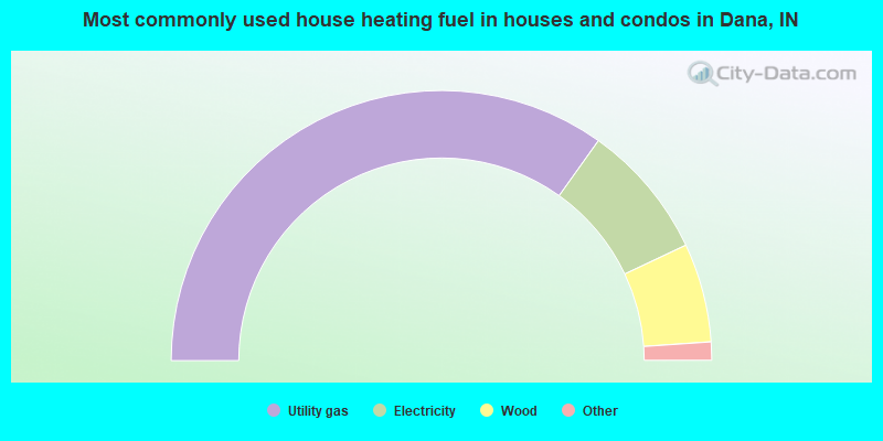
- 70.0%Utility gas
- 16.3%Electricity
- 11.9%Wood
- 1.1%Bottled, tank, or LP gas
- 0.7%No fuel used
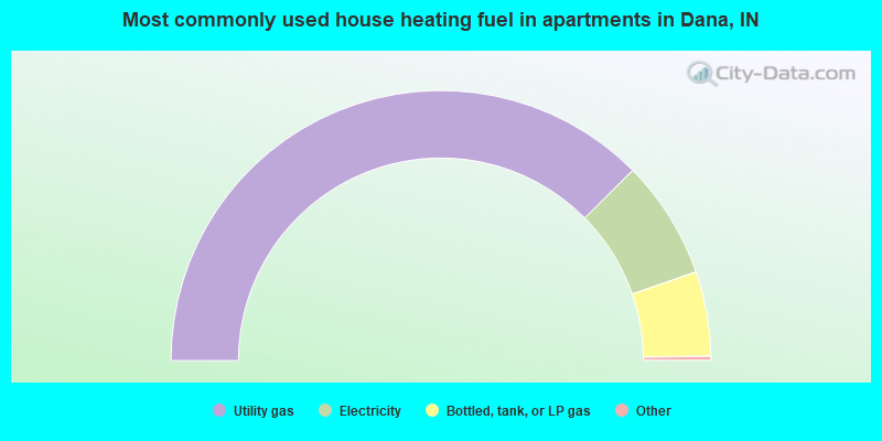
- 75.5%Utility gas
- 14.3%Electricity
- 10.2%Bottled, tank, or LP gas
Dana compared to Indiana state average:
- Median house value significantly below state average.
- Unemployed percentage significantly below state average.
- Black race population percentage significantly below state average.
- Hispanic race population percentage significantly below state average.
- Foreign-born population percentage below state average.
- Renting percentage below state average.
- Length of stay since moving in significantly above state average.
- House age significantly above state average.
- Number of college students significantly below state average.
- Percentage of population with a bachelor's degree or higher significantly below state average.