Denver, Iowa
Submit your own pictures of this city and show them to the world
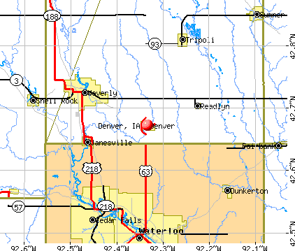
- OSM Map
- General Map
- Google Map
- MSN Map
Population change since 2000: +19.4%
 |
| Males: 913 | |
| Females: 1,029 |
| Median resident age: | 37.1 years |
| Iowa median age: | 38.9 years |
Zip codes: 50622.
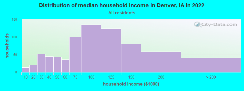
| Denver: | $82,935 |
| IA: | $69,588 |
Estimated per capita income in 2022: $38,176 (it was $20,791 in 2000)
Denver city income, earnings, and wages data
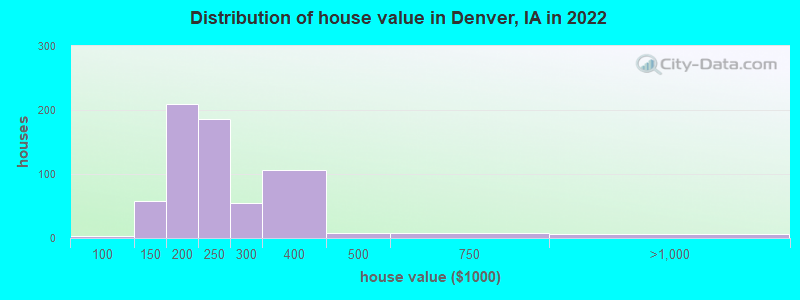
Estimated median house or condo value in 2022: $224,604 (it was $94,300 in 2000)
| Denver: | $224,604 |
| IA: | $194,600 |
Mean prices in 2022: all housing units: $267,500; detached houses: $277,589; townhouses or other attached units: $231,860; in 2-unit structures: $192,423; in 3-to-4-unit structures: $149,503; in 5-or-more-unit structures: $133,099; mobile homes: $24,938
Median gross rent in 2022: $706.
Detailed information about poverty and poor residents in Denver, IA
Compare current foreclosures near Denver, IA:
| Photo | Address | Area | Beds / Baths | Price | Details |
|---|---|---|---|---|---|

|
#1
Joplin Ave
Denver, IA 50622
|
960 sq. feet
|
- baths 4 beds |
show details | |

|
#2
Oneida St
Waterloo, IA 50703
|
1,177 sq. feet
|
1 baths 3 beds |
$99,900
|
show details |

|
#3
Longfellow Ave
Waterloo, IA 50703
|
900 sq. feet
|
1 baths 3 beds |
$174,900
|
show details |

|
#4
E End Ave
Evansdale, IA 50707
|
1,506 sq. feet
|
1 baths 3 beds |
$22,500
|
show details |

|
#5
Goodell Ave
Readlyn, IA 50668
|
1,104 sq. feet
|
2 baths 2 beds |
show details | |

|
#6
Broadway St
Waterloo, IA 50703
|
972 sq. feet
|
1 baths 2 beds |
show details | |

|
#7
W 7th St
Waterloo, IA 50702
|
964 sq. feet
|
1 baths 2 beds |
show details | |

|
#8
Elston Ave
Waterloo, IA 50701
|
2,068 sq. feet
|
1 baths 3 beds |
show details | |

|
#9
Grand Blvd
Evansdale, IA 50707
|
1,021 sq. feet
|
1 baths 2 beds |
show details | |

|
#10
2nd St NE
Fairbank, IA 50629
|
1,030 sq. feet
|
2 baths 2 beds |
show details |
| Photo | Address | Area | Beds / Baths | Price | Details |
|---|---|---|---|---|---|

|
#11
Downing Ave
Waterloo, IA 50701
|
1,144 sq. feet
|
1 baths 4 beds |
show details | |

|
#12
Country Ln
Waterloo, IA 50701
|
1,747 sq. feet
|
2 baths 3 beds |
show details | |

|
#13
Belmont Ave
Waterloo, IA 50701
|
960 sq. feet
|
1 baths 2 beds |
show details | |

|
#14
Orchard Dr
Cedar Falls, IA 50613
|
1,363 sq. feet
|
2 baths 3 beds |
show details | |

|
#15
Downing Ave
Waterloo, IA 50701
|
1,268 sq. feet
|
1 baths 3 beds |
show details | |

|
#16
Reflection Ln
Waterloo, IA 50701
|
1,286 sq. feet
|
2 baths 2 beds |
show details | |

|
#17
Saint Andrews Ave
Waterloo, IA 50701
|
1,418 sq. feet
|
2 baths 2 beds |
show details | |

|
#18
Denver St
Waterloo, IA 50701
|
1,495 sq. feet
|
1 baths 4 beds |
show details | |

|
#19
Dearborn Ave
Evansdale, IA 50707
|
1,461 sq. feet
|
2 baths 3 beds |
show details | |

|
#20
Denver St
Waterloo, IA 50702
|
1,952 sq. feet
|
3 baths 3 beds |
show details |
| Photo | Address | Area | Beds / Baths | Price | Details |
|---|---|---|---|---|---|

|
#21
Adrian St
Waterloo, IA 50703
|
841 sq. feet
|
1 baths 2 beds |
show details | |

|
#22
Kingsley Ave
Waterloo, IA 50701
|
1,004 sq. feet
|
3 baths 2 beds |
show details | |

|
#23
E End Ave
Evansdale, IA 50707
|
576 sq. feet
|
2 baths 2 beds |
show details | |

|
#24
Campbell Ave
Waterloo, IA 50701
|
832 sq. feet
|
1 baths 3 beds |
show details | |

|
#25
Hawthorne Ave
Waterloo, IA 50702
|
1,600 sq. feet
|
1 baths 3 beds |
show details | |

|
#26
Byron Ave
Waterloo, IA 50702
|
752 sq. feet
|
1 baths 2 beds |
show details | |

|
#27
French St
Waterloo, IA 50703
|
816 sq. feet
|
1 baths 2 beds |
show details | |

|
#28
W 4th St
Waterloo, IA 50701
|
1,866 sq. feet
|
2 baths 3 beds |
show details | |

|
#29
E Mitchell Ave
Waterloo, IA 50702
|
486 sq. feet
|
1 baths 2 beds |
show details | |

|
#30
Randolph St
Waterloo, IA 50702
|
1,024 sq. feet
|
1 baths 3 beds |
show details |
| Photo | Address | Area | Beds / Baths | Price | Details |
|---|---|---|---|---|---|

|
#31
Quesada Ave
Cedar Falls, IA 50613
|
2,004 sq. feet
|
2 baths 2 beds |
show details | |

|
#32
River Forest Rd
Evansdale, IA 50707
|
1,808 sq. feet
|
1 baths 3 beds |
show details | |

|
#33
S Evans Rd
Evansdale, IA 50707
|
1,035 sq. feet
|
1 baths 2 beds |
show details | |

|
#34
Rachael St
Waterloo, IA 50701
|
1,552 sq. feet
|
2 baths 2 beds |
show details | |

|
#35
French St
Waterloo, IA 50703
|
816 sq. feet
|
1 baths 2 beds |
show details | |

|
#36
Sager Ave
Waterloo, IA 50701
|
932 sq. feet
|
2 baths 2 beds |
show details | |

|
#37
Woodmayr Dr
Waterloo, IA 50703
|
1,438 sq. feet
|
3 baths 3 beds |
show details | |

|
#38
Ford Rd
Cedar Falls, IA 50613
|
1,582 sq. feet
|
2 baths 3 beds |
show details | |

|
#39
Ricker St
Waterloo, IA 50703
|
1,024 sq. feet
|
1 baths 3 beds |
show details | |

|
#40
Riverside Dr
Waterloo, IA 50703
|
1,284 sq. feet
|
1 baths 2 beds |
show details |
| Photo | Address | Area | Beds / Baths | Price | Details |
|---|---|---|---|---|---|

|
#41
Cedar Bend St
Waterloo, IA 50703
|
920 sq. feet
|
2 baths 3 beds |
show details | |

|
#42
Winslow Rd
Janesville, IA 50647
|
1,651 sq. feet
|
1 baths 3 beds |
show details | |

|
#43
W Dale St
Waterloo, IA 50703
|
1,113 sq. feet
|
1 baths 3 beds |
show details | |

|
#44
E Sycamore St
Dunkerton, IA 50626
|
1,428 sq. feet
|
1 baths 3 beds |
show details | |

|
#45
Cloverdale Ave
Waterloo, IA 50703
|
1,406 sq. feet
|
1 baths 2 beds |
show details | |

|
#46
Rainbow Dr
Cedar Falls, IA 50613
|
958 sq. feet
|
1 baths 2 beds |
show details | |

|
#47
W Parker St
Waterloo, IA 50703
|
856 sq. feet
|
1 baths 1 beds |
show details | |

|
#48
Letsch Rd
Waterloo, IA 50701
|
1,204 sq. feet
|
2 baths 3 beds |
show details | |

|
#49
Lakeside St
Waterloo, IA 50703
|
1,092 sq. feet
|
1 baths 3 beds |
show details | |

|
Check over 1 million property listings on Foreclosure.com!
|
browse all offers | |||


- 1,84295.5%White alone
- 542.8%Two or more races
- 100.5%Hispanic
- 70.4%Asian alone
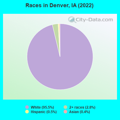
Races in Denver detailed stats: ancestries, foreign born residents, place of birth
According to our research of Iowa and other state lists, there were 5 registered sex offenders living in Denver, Iowa as of May 13, 2024.
The ratio of all residents to sex offenders in Denver is 366 to 1.
Full-time law enforcement employees in 2021, including police officers: 3 (3 officers - 3 male; 0 female).
| Officers per 1,000 residents here: | 1.59 |
| Iowa average: | 1.76 |
 Recent articles from our blog. Our writers, many of them Ph.D. graduates or candidates, create easy-to-read articles on a wide variety of topics.

 | Why is Iowa often seen as being very exemplary of American culture and society? (58 replies) |
| Driving I-80 across Iowa question (34 replies) |
| Anyone moved to Iowa from Minn.? Seriously thinking about it. (36 replies) |
| What is a summer in Davenport like? (10 replies) |
| Anyone here from Traer? (9 replies) |
| Red Flag Warning (2 replies) |
Latest news from Denver, IA collected exclusively by city-data.com from local newspapers, TV, and radio stations
Ancestries: German (60.9%), Irish (8.6%), American (6.9%), Norwegian (4.5%), English (4.2%), Croatian (1.8%).
Current Local Time: CST time zone
Incorporated on 06/30/1896
Elevation: 940 feet
Land area: 1.38 square miles.
Population density: 1,406 people per square mile (low).
22 residents are foreign born
| This city: | 1.1% |
| Iowa: | 5.6% |
Median real estate property taxes paid for housing units with mortgages in 2022: $2,594 (1.2%)
Median real estate property taxes paid for housing units with no mortgage in 2022: $2,876 (1.2%)
Nearest city with pop. 50,000+: Waterloo, IA  (12.4 miles , pop. 68,747).
Nearest city with pop. 200,000+: Madison, WI (151.5 miles , pop. 208,054).
Nearest city with pop. 1,000,000+: Chicago, IL (245.1 miles , pop. 2,896,016).
Nearest cities:
), ), )Latitude: 42.67 N, Longitude: 92.33 W
Area code: 319
| Here: | 2.1% |
| Iowa: | 2.7% |
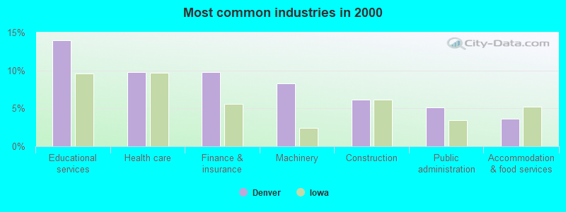
- Educational services (14.0%)
- Health care (9.7%)
- Finance & insurance (9.7%)
- Machinery (8.2%)
- Construction (6.2%)
- Public administration (5.2%)
- Accommodation & food services (3.7%)
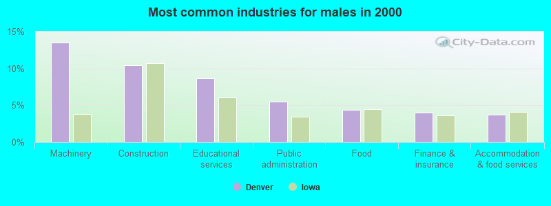
- Machinery (13.5%)
- Construction (10.4%)
- Educational services (8.6%)
- Public administration (5.5%)
- Food (4.4%)
- Finance & insurance (4.0%)
- Accommodation & food services (3.8%)
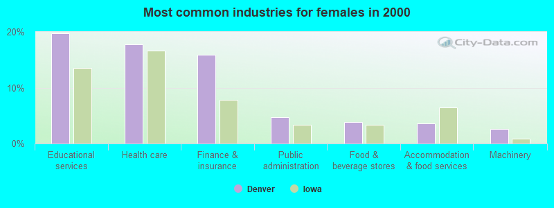
- Educational services (19.7%)
- Health care (17.8%)
- Finance & insurance (15.9%)
- Public administration (4.8%)
- Food & beverage stores (3.8%)
- Accommodation & food services (3.6%)
- Machinery (2.6%)
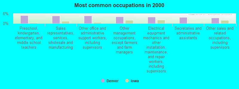
- Preschool, kindergarten, elementary, and middle school teachers (4.9%)
- Sales representatives, services, wholesale and manufacturing (4.8%)
- Other office and administrative support workers, including supervisors (4.8%)
- Other management occupations, except farmers and farm managers (4.1%)
- Electrical equipment mechanics and other installation, maintenance, and repair workers, including supervisors (4.0%)
- Secretaries and administrative assistants (3.8%)
- Other sales and related occupations, including supervisors (3.4%)
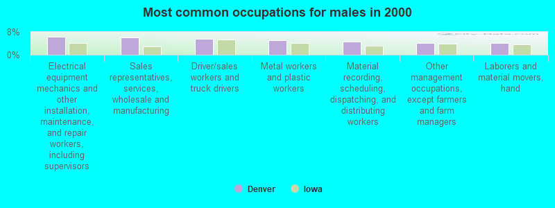
- Electrical equipment mechanics and other installation, maintenance, and repair workers, including supervisors (6.4%)
- Sales representatives, services, wholesale and manufacturing (6.0%)
- Driver/sales workers and truck drivers (5.5%)
- Metal workers and plastic workers (5.1%)
- Material recording, scheduling, dispatching, and distributing workers (4.6%)
- Other management occupations, except farmers and farm managers (4.2%)
- Laborers and material movers, hand (4.2%)

- Other office and administrative support workers, including supervisors (8.1%)
- Secretaries and administrative assistants (7.8%)
- Preschool, kindergarten, elementary, and middle school teachers (6.4%)
- Registered nurses (4.3%)
- Bookkeeping, accounting, and auditing clerks (4.3%)
- Other management occupations, except farmers and farm managers (4.0%)
- Other financial specialists (3.8%)
Average climate in Denver, Iowa
Based on data reported by over 4,000 weather stations


|
|

(lower is better)
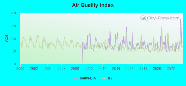
Air Quality Index (AQI) level in 2023 was 95.4. This is worse than average.
| City: | 95.4 |
| U.S.: | 72.6 |
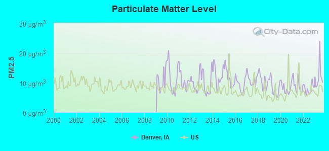
Particulate Matter (PM2.5) [µg/m3] level in 2023 was 12.1. This is significantly worse than average. Closest monitor was 10.4 miles away from the city center.
| City: | 12.1 |
| U.S.: | 8.1 |
Tornado activity:
Denver-area historical tornado activity is near Iowa state average. It is 101% greater than the overall U.S. average.
On 5/15/1968, a category F5 (max. wind speeds 261-318 mph) tornado 20.5 miles away from the Denver city center killed 5 people and injured 156 people and caused between $5,000,000 and $50,000,000 in damages.
On 5/25/2008, a category F5 tornado 29.1 miles away from the city center killed 9 people and injured 70 people and caused $100 million in damages.
Earthquake activity:
Denver-area historical earthquake activity is significantly above Iowa state average. It is 121% greater than the overall U.S. average.On 4/18/2008 at 09:36:59, a magnitude 5.4 (5.1 MB, 4.8 MS, 5.4 MW, 5.2 MW, Class: Moderate, Intensity: VI - VII) earthquake occurred 373.8 miles away from the city center
On 6/10/1987 at 23:48:54, a magnitude 5.1 (4.9 MB, 4.4 MS, 4.6 MS, 5.1 LG) earthquake occurred 353.9 miles away from Denver center
On 6/28/2004 at 06:10:52, a magnitude 4.2 (4.2 MW, Depth: 6.2 mi, Class: Light, Intensity: IV - V) earthquake occurred 195.2 miles away from the city center
On 4/18/2008 at 09:36:59, a magnitude 5.2 (5.2 MW, Depth: 8.9 mi) earthquake occurred 373.8 miles away from Denver center
On 7/9/1975 at 14:54:15, a magnitude 4.6 (4.6 MB) earthquake occurred 277.1 miles away from Denver center
On 9/3/2016 at 12:02:44, a magnitude 5.8 (5.8 MW, Depth: 3.5 mi) earthquake occurred 496.6 miles away from the city center
Magnitude types: regional Lg-wave magnitude (LG), body-wave magnitude (MB), surface-wave magnitude (MS), moment magnitude (MW)
Natural disasters:
The number of natural disasters in Bremer County (16) is near the US average (15).Major Disasters (Presidential) Declared: 13
Emergencies Declared: 1
Causes of natural disasters: Floods: 13, Storms: 10, Tornadoes: 4, Heavy Rains: 2, Hurricane: 1, Wind: 1, Winter Storm: 1, Other: 1 (Note: some incidents may be assigned to more than one category).

Hospitals and medical centers in Denver:
Other hospitals and medical centers near Denver:
- COUNTRY VIEW (Nursing Home, about 8 miles away; WATERLOO, IA)
- COMMUNITY BASED SERVICES HOME HEALTH (Home Health Center, about 8 miles away; WAVERLY, IA)
- WAVERLY HEALTH CENTER Critical Access Hospitals (about 9 miles away; WAVERLY, IA)
- CEDAR VALLEY WAVERLY DIALYSIS (Dialysis Facility, about 9 miles away; WAVERLY, IA)
- BREMER-BUTLER HOSPICE (Hospital, about 10 miles away; WAVERLY, IA)
- ALLEN HOME HEALTH SERVICES (Home Health Center, about 11 miles away; WATERLOO, IA)
- ALLEN MEMORIAL HOSPITAL Acute Care Hospitals (about 11 miles away; WATERLOO, IA)
Colleges/universities with over 2000 students nearest to Denver:
- University of Northern Iowa (about 13 miles; Cedar Falls, IA; Full-time enrollment: 10,816)
- Hawkeye Community College (about 17 miles; Waterloo, IA; FT enrollment: 7,160)
- Upper Iowa University (about 30 miles; Fayette, IA; FT enrollment: 5,275)
- Northeast Iowa Community College-Calmar (about 43 miles; Calmar, IA; FT enrollment: 3,365)
- Luther College (about 52 miles; Decorah, IA; FT enrollment: 2,700)
- North Iowa Area Community College (about 53 miles; Mason City, IA; FT enrollment: 2,235)
- Kirkwood Community College (about 64 miles; Cedar Rapids, IA; FT enrollment: 11,503)
Public high school in Denver:
- DENVER SENIOR HIGH SCHOOL (Students: 222, Location: 541 E EAGLE, Grades: 9-12)
Public elementary/middle schools in Denver:
- DENVER MIDDLE SCHOOL (Students: 177, Location: 540 LINCOLN, Grades: 6-8)
- K-5 ELEMENTARY SCHOOL LINCOLN STREET BUILDING (Location: 530 LINCOLN, Grades: KG-5)
Points of interest:
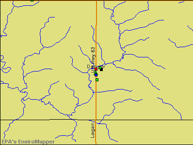
Notable locations in Denver: Denver Ambulance Service (A), Denver Public Library (B), Denver Fire Department (C), Denver City Hall (D), Denver Police Department (E). Display/hide their locations on the map
Churches in Denver include: Saint Peter Lutheran Church (A), Saint Paul United Church of Christ (B), Saint Johns Lutheran Church (C), Denver Baptist Church (D). Display/hide their locations on the map
Cemetery: Fairview Cemetery (1). Display/hide its location on the map
Parks in Denver include: Brandt Park (1), Prestien Park (2), Diercks Park (3), Denver City Park (4), Forrest Avenue Park (5). Display/hide their locations on the map
Drinking water stations with addresses in Denver and their reported violations in the past:
DENVER WATER SUPPLY (Population served: 1,780, Groundwater):Past monitoring violations:
- One regular monitoring violation
| This city: | 2.5 people |
| Iowa: | 2.4 people |
| This city: | 71.9% |
| Whole state: | 64.7% |
| This city: | 5.1% |
| Whole state: | 6.7% |
Likely homosexual households (counted as self-reported same-sex unmarried-partner households)
- Lesbian couples: 0.4% of all households
- Gay men: 0.3% of all households
30 people in nursing homes in 2000
Banks with branches in Denver (2011 data):
- Denver Savings Bank: at 121 South State Street, branch established on 1902/01/01. Info updated 2006/11/03: Bank assets: $124.5 mil, Deposits: $101.4 mil, local headquarters, positive income, 1 total offices, Holding Company: Psb Corporation
For population 15 years and over in Denver:
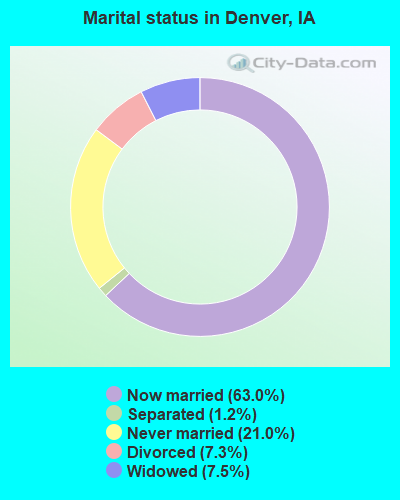
- Never married: 21.0%
- Now married: 63.0%
- Separated: 1.2%
- Widowed: 7.5%
- Divorced: 7.3%
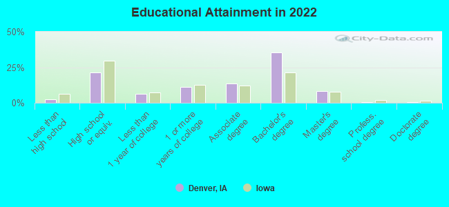
For population 25 years and over in Denver:
- High school or higher: 97.5%
- Bachelor's degree or higher: 42.8%
- Graduate or professional degree: 8.8%
- Unemployed: 1.0%
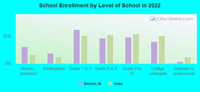
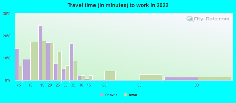
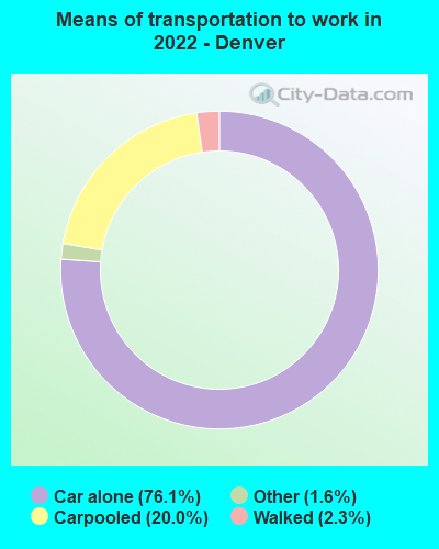
- Mean travel time to work (commute): 18.0 minutes
| Here: | 8.3 |
| Iowa average: | 10.5 |
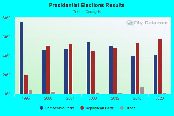
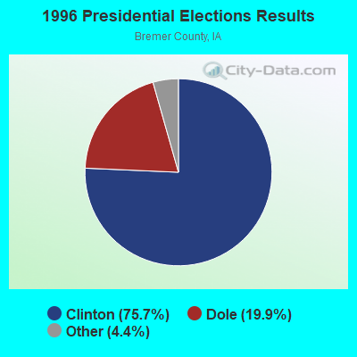
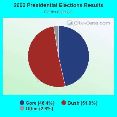
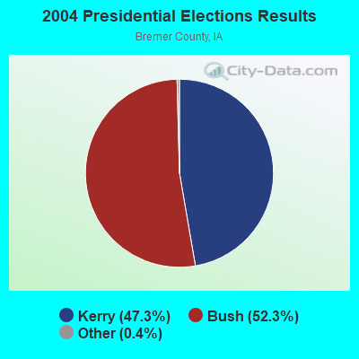
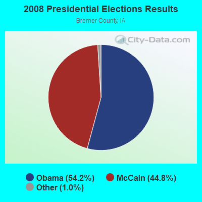
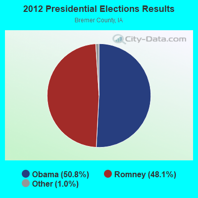
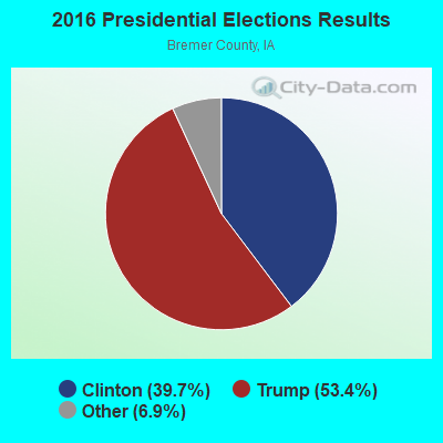
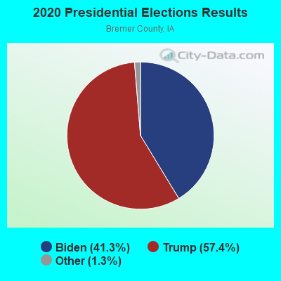
Graphs represent county-level data. Detailed 2008 Election Results
Religion statistics for Denver, IA (based on Bremer County data)
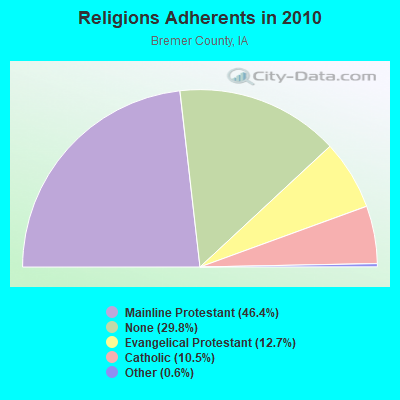
| Religion | Adherents | Congregations |
|---|---|---|
| Mainline Protestant | 11,274 | 23 |
| Evangelical Protestant | 3,080 | 22 |
| Catholic | 2,558 | 2 |
| Other | 140 | 1 |
| None | 7,224 | - |
Food Environment Statistics:
| Bremer County: | 2.11 / 10,000 pop. |
| Iowa: | 2.14 / 10,000 pop. |
| Here: | 5.48 / 10,000 pop. |
| State: | 5.55 / 10,000 pop. |
| Bremer County: | 8.85 / 10,000 pop. |
| Iowa: | 8.01 / 10,000 pop. |
| Here: | 7.4% |
| State: | 7.8% |
| Bremer County: | 27.1% |
| Iowa: | 27.3% |
| Here: | 13.1% |
| State: | 14.5% |
Health and Nutrition:
| Denver: | 52.2% |
| Iowa: | 49.5% |
| Denver: | 48.3% |
| Iowa: | 46.1% |
| This city: | 28.9 |
| Iowa: | 28.6 |
| Here: | 15.4% |
| Iowa: | 21.4% |
| This city: | 20.6% |
| Iowa: | 10.4% |
| Denver: | 6.5 |
| Iowa: | 6.8 |
| This city: | 36.9% |
| Iowa: | 33.8% |
| This city: | 53.7% |
| Iowa: | 55.9% |
| This city: | 84.6% |
| Iowa: | 77.7% |
More about Health and Nutrition of Denver, IA Residents
| Local government employment and payroll (March 2022) | |||||
| Function | Full-time employees | Monthly full-time payroll | Average yearly full-time wage | Part-time employees | Monthly part-time payroll |
|---|---|---|---|---|---|
| Police Protection - Officers | 3 | $14,915 | $59,660 | 0 | $0 |
| Electric Power | 2 | $18,602 | $111,612 | 0 | $0 |
| Streets and Highways | 1 | $5,691 | $68,292 | 0 | $0 |
| Health | 1 | $4,692 | $56,304 | 0 | $0 |
| Other Government Administration | 1 | $3,593 | $43,116 | 1 | $1,305 |
| Local Libraries | 1 | $3,698 | $44,376 | 2 | $3,317 |
| Water Supply | 1 | $4,357 | $52,284 | 0 | $0 |
| Sewerage | 1 | $8,859 | $106,308 | 0 | $0 |
| Parks and Recreation | 1 | $3,543 | $42,516 | 0 | $0 |
| Other and Unallocable | 0 | $0 | 1 | $1,417 | |
| Totals for Government | 12 | $67,948 | $67,948 | 4 | $6,039 |
Denver government finances - Expenditure in 2017 (per resident):
- Construction - Regular Highways: $188,000 ($96.81)
Sewerage: $117,000 ($60.25)
- Current Operations - Electric Utilities: $1,510,000 ($777.55)
General - Other: $634,000 ($326.47)
Regular Highways: $252,000 ($129.76)
Police Protection: $238,000 ($122.55)
Sewerage: $170,000 ($87.54)
Libraries: $152,000 ($78.27)
Water Utilities: $144,000 ($74.15)
Solid Waste Management: $139,000 ($71.58)
Health - Other: $86,000 ($44.28)
Parks and Recreation: $53,000 ($27.29)
General Public Buildings: $39,000 ($20.08)
Financial Administration: $37,000 ($19.05)
Judicial and Legal Services: $35,000 ($18.02)
Local Fire Protection: $30,000 ($15.45)
Central Staff Services: $28,000 ($14.42)
- General - Interest on Debt: $167,000 ($85.99)
- Other Capital Outlay - Health - Other: $220,000 ($113.29)
Regular Highways: $22,000 ($11.33)
Local Fire Protection: $1,000 ($0.51)
- Total Salaries and Wages: $655,000 ($337.28)
Denver government finances - Revenue in 2017 (per resident):
- Charges - Sewerage: $552,000 ($284.24)
Solid Waste Management: $118,000 ($60.76)
Other: $108,000 ($55.61)
Parks and Recreation: $25,000 ($12.87)
Miscellaneous Commercial Activities: $2,000 ($1.03)
- Local Intergovernmental - Other: $146,000 ($75.18)
- Miscellaneous - General Revenue - Other: $138,000 ($71.06)
Interest Earnings: $29,000 ($14.93)
Fines and Forfeits: $11,000 ($5.66)
Rents: $7,000 ($3.60)
- Revenue - Electric Utilities: $1,411,000 ($726.57)
Water Utilities: $160,000 ($82.39)
Gas Utilities: $3,000 ($1.54)
- State Intergovernmental - Highways: $221,000 ($113.80)
Other: $10,000 ($5.15)
General Local Government Support: $1,000 ($0.51)
- Tax - Property: $599,000 ($308.44)
General Sales and Gross Receipts: $182,000 ($93.72)
Other License: $14,000 ($7.21)
Denver government finances - Debt in 2017 (per resident):
- Long Term Debt - Beginning Outstanding - Unspecified Public Purpose: $8,220,000 ($4232.75)
Outstanding Unspecified Public Purpose: $7,658,000 ($3943.36)
Retired Unspecified Public Purpose: $562,000 ($289.39)
Denver government finances - Cash and Securities in 2017 (per resident):
- Other Funds - Cash and Securities: $1,414,000 ($728.12)
Businesses in Denver, IA
- MasterBrand Cabinets: 2
Strongest AM radio stations in Denver:
- KCNZ (1250 AM; 10 kW; CEDAR FALLS, IA; Owner: FIFE COMMUNICATION COMPANY, L.C.)
- KXEL (1540 AM; 50 kW; WATERLOO, IA; Owner: KXEL BROADCASTING COMPANY, INC.)
- KWLO (1330 AM; 5 kW; WATERLOO, IA; Owner: KXEL BROADCASTING COMPANY, INC.)
- KDNZ (1650 AM; 10 kW; CEDAR FALLS, IA; Owner: FIFE COMMUNICATIONS CO., LLC)
- KWAY (1470 AM; 1 kW; WAVERLY, IA; Owner: AEL SUHR ENTERPRISES, INC.)
- KKHQ (950 AM; 5 kW; OELWEIN, IA; Owner: CUMULUS LICENSING CORP.)
- WHO (1040 AM; 50 kW; DES MOINES, IA; Owner: CITICASTERS LICENSES, L.P.)
- KNWS (1090 AM; daytime; 1 kW; WATERLOO, IA; Owner: NORTHWESTERN COLLEGE)
- KWOF (850 AM; daytime; 0 kW; WATERLOO, IA; Owner: FRIENDSHIP COMMUNICATIONS,INC.)
- WMT (600 AM; 5 kW; CEDAR RAPIDS, IA; Owner: CITICASTERS LICENSES, L.P.)
- KFAN (1130 AM; 50 kW; MINNEAPOLIS, MN; Owner: AMFM RADIO LICENSES, L.L.C.)
- WCTS (1030 AM; 50 kW; MAPLEWOOD, MN; Owner: CNTL. BAPT. THEO/AL SEMI MINNEAPOLIS)
- WCCO (830 AM; 50 kW; MINNEAPOLIS, MN; Owner: INFINITY MEDIA CORPORATION)
Strongest FM radio stations in Denver:
- KOEL-FM (92.3 FM; OELWEIN, IA; Owner: CUMULUS LICENSING CORP.)
- KOKZ (105.7 FM; WATERLOO, IA; Owner: KXEL BROADCASTING COMPANY, INC.)
- KFMW (107.9 FM; WATERLOO, IA; Owner: KXEL BROADCASTING COMPANY, INC.)
- KUNI (90.9 FM; CEDAR FALLS, IA; Owner: UNIVERSITY OF NORTHERN IOWA)
- KNWS-FM (101.9 FM; WATERLOO, IA; Owner: NORTHWESTERN COLLEGE)
- KWAY-FM (99.3 FM; WAVERLY, IA; Owner: AEL SUHR ENTERPRISES, INC.)
- KOEL (98.5 FM; CEDAR FALLS, IA; Owner: CUMULUS LICENSING CORP.)
- KHKE (89.5 FM; CEDAR FALLS, IA; Owner: UNIVERSITY OF NORTHERN IOWA)
- KBBG (88.1 FM; WATERLOO, IA; Owner: AFRO AMERICAN COMMUNITY B/CSTING,INC)
- KCVM (96.1 FM; HUDSON, IA; Owner: FIFE COMMUNICATION COMPANY, L.C.)
- KQMG-FM (95.3 FM; INDEPENDENCE, IA; Owner: KEENE OF IOWA, INC.)
- KCZE (95.1 FM; NEW HAMPTON, IA; Owner: CLEAR CHANNEL BROADCASTING LICENSES, INC.)
TV broadcast stations around Denver:
- KWWL (Channel 7; WATERLOO, IA; Owner: RAYCOM AMERICA, INC.)
- KGAN (Channel 2; CEDAR RAPIDS, IA; Owner: KGAN LICENSEE, LLC)
- KCRG-TV (Channel 9; CEDAR RAPIDS, IA; Owner: CEDAR RAPIDS TELEVISION CO.)
- KRIN (Channel 32; WATERLOO, IA; Owner: IOWA PUBLIC BROADCASTING BOARD)
- KYIN (Channel 24; MASON CITY, IA; Owner: IOWA PUBLIC BROADCASTING BOARD)
- KPXR (Channel 48; CEDAR RAPIDS, IA; Owner: PAXSON COMMUNICATIONS LICENSE COMPANY, LLC)
- K44FK (Channel 44; WATERLOO, IA; Owner: TRINITY BROADCASTING NETWORK)
- KTTC (Channel 10; ROCHESTER, MN; Owner: KTTC TELEVISION, INC.)
Denver fatal accident list:
- National Bridge Inventory (NBI) Statistics
- 36Number of bridges
- 292ft / 89.5mTotal length
- 46,805Total average daily traffic
- 5,795Total average daily truck traffic
- New bridges - historical statistics
- 21920-1929
- 11940-1949
- 21950-1959
- 31960-1969
- 11970-1979
- 21980-1989
- 101990-1999
- 62000-2009
- 92010-2019
FCC Registered Cell Phone Towers:
1 (See the full list of FCC Registered Cell Phone Towers in Denver)FCC Registered Antenna Towers:
12 (See the full list of FCC Registered Antenna Towers)FCC Registered Broadcast Land Mobile Towers:
5- 3.9 Mi E 2 Mi S Of Hwy 63 & C50 (Lat: 42.642472 Lon: -92.260472), Structure height: 9 m, Call Sign: WNAA346,
Assigned Frequencies: 151.565 MHz, Grant Date: 09/08/1999, Expiration Date: 10/19/2004, Cancellation Date: 12/25/2004, Registrant: Agvantage Fs, Inc., 1600 8th Street Sw, Waverly, IA 50677-0828, Phone: (319) 483-4900, Fax: (319) 483-4992, Email:
- 107 N State St (Lat: 42.671361 Lon: -92.329639), Call Sign: WNCP995,
Assigned Frequencies: 173.337 MHz, Grant Date: 03/03/2015, Expiration Date: 05/22/2025, Registrant: Denver Municipal Utilities, 100 Washington Street, Denver, IA 50622, Phone: (319) 984-5642, Fax: (319) 984-6013
- Lat: 42.669917 Lon: -92.330722, Call Sign: WQNU812,
Assigned Frequencies: 72.1400 MHz, Grant Date: 06/02/2011, Expiration Date: 06/02/2021, Cancellation Date: 08/07/2021, Certifier: Kathryn Enslin, Registrant: Primex Wireless, Inc., 965 Wells Street, Lake Geneva, WI 53147, Phone: (800) 537-0464
- Lat: 42.671417 Lon: -92.325528, Call Sign: WQNV241,
Assigned Frequencies: 452.437 MHz, 457.437 MHz, Grant Date: 06/04/2021, Expiration Date: 06/06/2031, Certifier: Mike Milbrendt, Registrant: Cara Enterprises Inc, Las Vegas, NV 89140-0124, Phone: (702) 838-9728, Fax: (702) 363-4607, Email:
- Lat: 42.665278 Lon: -92.324389, Call Sign: WRPJ747,
Assigned Frequencies: 72.2200 MHz, Grant Date: 02/14/2022, Expiration Date: 02/14/2032, Certifier: Chris Mccarville, Registrant: Primex Wireless, Inc., 965 S Wells St, Lake Geneva, WI 53147, Phone: (262) 729-4858, Email:
FCC Registered Microwave Towers:
3- DENVER, 2660 Midway Ave (Lat: 42.662083 Lon: -92.318528), Type: Tower, Structure height: 76.2 m, Overall height: 80.8 m, Call Sign: WQOR469,
Assigned Frequencies: 6745.00 MHz, Grant Date: 01/06/2012, Expiration Date: 01/06/2022, Cancellation Date: 11/01/2012, Certifier: Steven T Campbell, Registrant: Holland & Knight LLP, 800 17th Street, N.W., Suite #1100, Washington, DC 20006-3906, Phone: (202) 955-3000, Fax: (202) 955-5564, Email:
- DENVER, 2578 Navaho Road (Lat: 42.674278 Lon: -92.299472), Type: Tower, Structure height: 91.4 m, Overall height: 93.9 m, Call Sign: WQPH770,
Assigned Frequencies: 6197.24 MHz, 6345.49 MHz, Grant Date: 04/19/2022, Expiration Date: 05/22/2032, Certifier: Gregory M Romano, Registrant: Cellco Partnership, 5055 North Point Pkwy, Np2ne Network Engineering, Alpharetta, GA 30022, Phone: (770) 797-1070, Email:
- DM03IP650, 2578 Navaho Road (Lat: 42.674278 Lon: -92.299472), Type: Ltower, Structure height: 91.4 m, Overall height: 93.9 m, Call Sign: WQWV482,
Assigned Frequencies: 10835.0 MHz, 10835.0 MHz, 10835.0 MHz, 10835.0 MHz, 10835.0 MHz, 10835.0 MHz, 10835.0 MHz, Grant Date: 12/01/2015, Expiration Date: 12/01/2025, Cancellation Date: 05/12/2023, Certifier: David Werblow, Registrant: T-Mobile Usa, Inc., 12920 Se 38th Street, Bellevue, WA 98006, Phone: (425) 383-8401, Email:
FCC Registered Amateur Radio Licenses:
8 (See the full list of FCC Registered Amateur Radio Licenses in Denver)FAA Registered Aircraft:
1- Aircraft: CESSNA T303 (Category: Land, Engines: 2, Seats: 4, Weight: Up to 12,499 Pounds), Engine: CONT MOTOR TSIO-520 SER (300 HP) (Reciprocating)
N-Number: 382CR, N382CR, N-382CR, Serial Number: T30300096, Year manufactured: 1982, Airworthiness Date: 03/18/1982, Certificate Issue Date: 07/31/1992
Registrant (Corporation): Schumacher Elevator Co Inc, 1 Schumacher Way, Denver, IA 50622
2008 - 2017 National Fire Incident Reporting System (NFIRS) incidents
- Fire incident types reported to NFIRS in Denver, IA
- 4747.0%Outside Fires
- 2727.0%Structure Fires
- 1818.0%Mobile Property/Vehicle Fires
- 88.0%Other
 According to the data from the years 2008 - 2017 the average number of fire incidents per year is 10. The highest number of fires - 18 took place in 2015, and the least - 0 in 2009. The data has a growing trend.
 When looking into fire subcategories, the most incidents belonged to: Outside Fires (47.0%), and Structure Fires (27.0%).
| Most common first names in Denver, IA among deceased individuals | ||
| Name | Count | Lived (average) |
|---|---|---|
| John | 16 | 80.6 years |
| William | 16 | 80.7 years |
| Arthur | 12 | 81.8 years |
| Fred | 11 | 82.6 years |
| Harold | 11 | 74.3 years |
| Ernest | 10 | 82.7 years |
| Henry | 10 | 82.1 years |
| Emma | 9 | 91.0 years |
| Mary | 9 | 77.2 years |
| Margaret | 8 | 87.9 years |
| Most common last names in Denver, IA among deceased individuals | ||
| Last name | Count | Lived (average) |
|---|---|---|
| Hesse | 10 | 80.1 years |
| Gielau | 10 | 78.8 years |
| Bruns | 10 | 82.2 years |
| Steege | 9 | 83.5 years |
| Walther | 9 | 77.5 years |
| Buss | 8 | 77.9 years |
| Platte | 7 | 78.2 years |
| Schumacher | 7 | 89.3 years |
| Matthias | 7 | 80.9 years |
| Wille | 6 | 81.7 years |
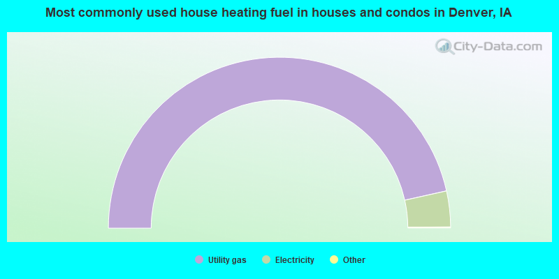
- 93.2%Utility gas
- 6.8%Electricity
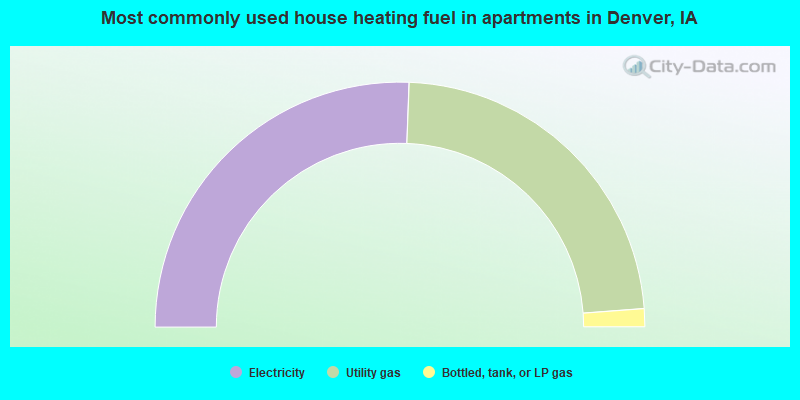
- 51.2%Electricity
- 46.4%Utility gas
- 2.4%Bottled, tank, or LP gas
Denver compared to Iowa state average:
- Unemployed percentage significantly below state average.
- Black race population percentage significantly below state average.
- Hispanic race population percentage significantly below state average.
- Median age below state average.
- Foreign-born population percentage significantly below state average.
- Length of stay since moving in above state average.
- Percentage of population with a bachelor's degree or higher above state average.

|
|
Total of 49 patent applications in 2008-2024.