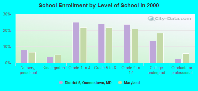
District 5, Queenstown, Maryland
Submit your own pictures of this city and show them to the world
- OSM Map
- General Map
- Google Map
- MSN Map

| Males: 4,416 | |
| Females: 4,460 |
| Median resident age: | 42.6 years |
| Maryland median age: | 36.0 years |
Zip code: 21638
| District 5, Queenstown: | $112,513 |
| MD: | $94,991 |
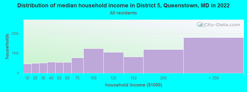
Estimated per capita income in 2022: $60,633 (it was $30,748 in 2000)
District 5, Queenstown income, earnings, and wages data
Estimated median house or condo value in 2022: $581,564 (it was $210,800 in 2000)
| District 5, Queenstown: | $581,564 |
| MD: | $398,100 |
Mean prices in 2022: all housing units: $539,193; detached houses: $551,367; townhouses or other attached units: $427,341; in 2-unit structures: $220,029; in 3-to-4-unit structures: $59,373; in 5-or-more-unit structures: $363,798; mobile homes: $284,885
District 5, Queenstown, MD residents, houses, and apartments details
Detailed information about poverty and poor residents in District 5, Queenstown, MD


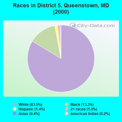
- 6,45583.5%White alone
- 1,03113.3%Black alone
- 1081.4%Hispanic
- 741.0%Two or more races
- 330.4%Asian alone
- 170.2%American Indian alone
- 50.06%Other race alone
- 40.05%Native Hawaiian and Other
Pacific Islander alone
Races in District 5, Queenstown detailed stats: ancestries, foreign born residents, place of birth
 Recent articles from our blog. Our writers, many of them Ph.D. graduates or candidates, create easy-to-read articles on a wide variety of topics.
Current Local Time: EST time zone
Land area: 54.3 square miles.
Population density: 163 people per square mile (very low).

| District 5, Queenstown: | 0.8% ($1,728) |
| Maryland: | 1.2% ($1,782) |
Nearest city with pop. 50,000+: Dundalk, MD  (27.5 miles , pop. 62,306).
Nearest city with pop. 200,000+: Baltimore, MD (33.6 miles , pop. 651,154).
Nearest city with pop. 1,000,000+: Philadelphia, PA (90.5 miles , pop. 1,517,550).
Nearest cities:
), ), Latitude: 38.96 N, Longitude: 76.18 W
Area code commonly used in this area: 410

| Here: | 1.6% |
| Maryland: | 2.0% |

- Public administration (10.2%)
- Construction (9.3%)
- Educational services (9.1%)
- Accommodation & food services (7.7%)
- Professional, scientific, technical services (7.4%)
- Health care (6.6%)
- Finance & insurance (4.6%)
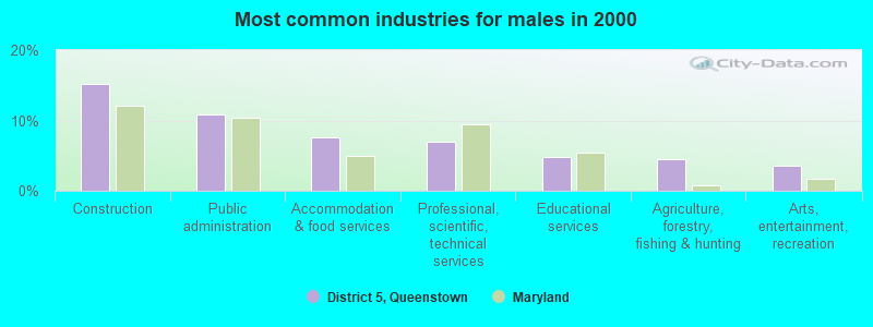
- Construction (15.1%)
- Public administration (10.9%)
- Accommodation & food services (7.6%)
- Professional, scientific, technical services (7.0%)
- Educational services (4.7%)
- Agriculture, forestry, fishing & hunting (4.5%)
- Arts, entertainment, recreation (3.5%)
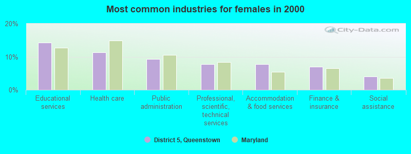
- Educational services (14.2%)
- Health care (11.4%)
- Public administration (9.3%)
- Professional, scientific, technical services (7.8%)
- Accommodation & food services (7.7%)
- Finance & insurance (7.0%)
- Social assistance (4.0%)
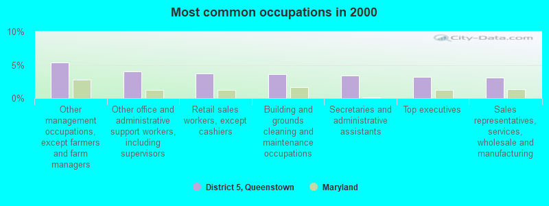
- Other management occupations, except farmers and farm managers (5.4%)
- Other office and administrative support workers, including supervisors (4.0%)
- Retail sales workers, except cashiers (3.7%)
- Building and grounds cleaning and maintenance occupations (3.6%)
- Secretaries and administrative assistants (3.4%)
- Top executives (3.2%)
- Sales representatives, services, wholesale and manufacturing (3.0%)
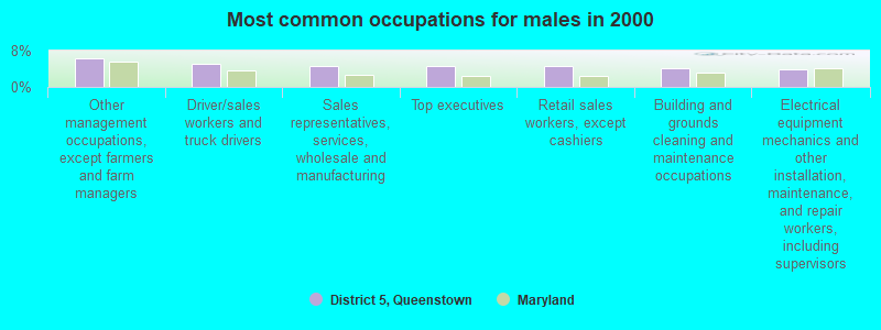
- Other management occupations, except farmers and farm managers (6.4%)
- Driver/sales workers and truck drivers (5.0%)
- Sales representatives, services, wholesale and manufacturing (4.7%)
- Top executives (4.6%)
- Retail sales workers, except cashiers (4.6%)
- Building and grounds cleaning and maintenance occupations (4.1%)
- Electrical equipment mechanics and other installation, maintenance, and repair workers, including supervisors (3.8%)
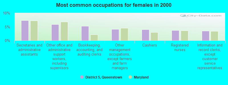
- Secretaries and administrative assistants (7.3%)
- Other office and administrative support workers, including supervisors (5.8%)
- Bookkeeping, accounting, and auditing clerks (5.2%)
- Other management occupations, except farmers and farm managers (4.1%)
- Cashiers (4.0%)
- Registered nurses (3.8%)
- Information and record clerks, except customer service representatives (3.5%)
Average climate in District 5, Queenstown, Maryland
Based on data reported by over 4,000 weather stations


(lower is better)
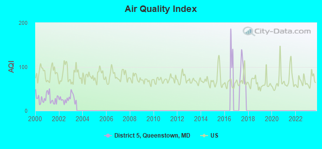
Air Quality Index (AQI) level in 2017 was 89.5. This is worse than average.
| City: | 89.5 |
| U.S.: | 72.6 |
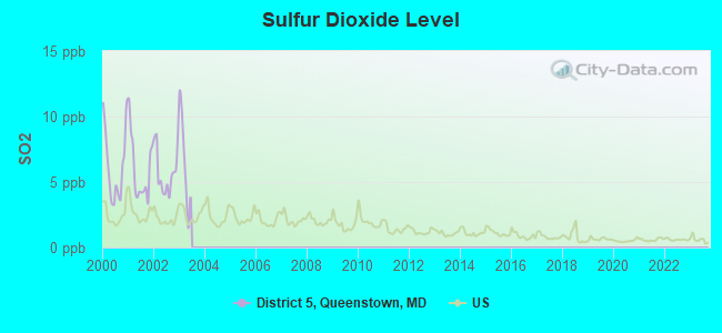
Sulfur Dioxide (SO2) [ppb] level in 2002 was 5.75. This is significantly worse than average. Closest monitor was 17.6 miles away from the city center.
| City: | 5.75 |
| U.S.: | 1.51 |
Tornado activity:
District 5, Queenstown-area historical tornado activity is near Maryland state average. It is 7% smaller than the overall U.S. average.
On 4/28/2002, a category F4 (max. wind speeds 207-260 mph) tornado 37.5 miles away from the District 5, Queenstown city center killed 3 people and injured 122 people and caused $124 million in damages.
On 6/9/1961, a category F3 (max. wind speeds 158-206 mph) tornado 28.9 miles away from the city center caused between $50,000 and $500,000 in damages.
Earthquake activity:
District 5, Queenstown-area historical earthquake activity is significantly above Maryland state average. It is 62% smaller than the overall U.S. average.On 8/23/2011 at 17:51:04, a magnitude 5.8 (5.8 MW, Depth: 3.7 mi, Class: Moderate, Intensity: VI - VII) earthquake occurred 119.8 miles away from the city center
On 1/16/1994 at 01:49:16, a magnitude 4.6 (4.6 MB, 4.6 LG, Depth: 3.1 mi, Class: Light, Intensity: IV - V) earthquake occurred 95.0 miles away from the city center
On 8/25/2011 at 05:07:52, a magnitude 4.5 (4.5 ML, Depth: 4.2 mi) earthquake occurred 119.6 miles away from District 5, Queenstown center
On 11/30/2017 at 21:47:31, a magnitude 4.1 (4.1 MW, Depth: 6.1 mi) earthquake occurred 43.2 miles away from the city center
On 12/9/2003 at 20:59:18, a magnitude 4.5 (4.5 ML, Depth: 6.2 mi) earthquake occurred 132.7 miles away from District 5, Queenstown center
On 12/9/2003 at 20:59:14, a magnitude 4.5 (4.5 MB, 4.5 LG) earthquake occurred 133.4 miles away from District 5, Queenstown center
Magnitude types: regional Lg-wave magnitude (LG), body-wave magnitude (MB), local magnitude (ML), moment magnitude (MW)
Natural disasters:
The number of natural disasters in Queen Anne's County (14) is near the US average (15).Major Disasters (Presidential) Declared: 9
Emergencies Declared: 5
Causes of natural disasters: Hurricanes: 7, Winter Storms: 5, Snowstorms: 4, Blizzard: 1, Snowfall: 1 (Note: some incidents may be assigned to more than one category).
Hospitals and medical centers near District 5, Queenstown:
- CORSICA HILLS CENTER (Nursing Home, about 9 miles away; CENTREVILLE, MD)
- DAVITA - EASTON (Dialysis Facility, about 15 miles away; EASTON, MD)
- WILLIAM HILL MANOR HEALTHCARE (Nursing Home, about 16 miles away; EASTON, MD)
- ADVANCED DIALYSIS CENTER - EASTON (Dialysis Facility, about 16 miles away; EASTON, MD)
- THE PINES GENESIS ELDERCARE (Nursing Home, about 16 miles away; EASTON, MD)
- THE ARBOR (Nursing Home, about 16 miles away; ANNAPOLIS, MD)
Colleges/universities with over 2000 students nearest to District 5, Queenstown:
- United States Naval Academy (about 17 miles; Annapolis, MD; Full-time enrollment: 5,681)
- Anne Arundel Community College (about 20 miles; Arnold, MD; FT enrollment: 10,501)
- All-State Career-Baltimore (about 29 miles; Baltimore, MD; FT enrollment: 2,287)
- Bowie State University (about 32 miles; Bowie, MD; FT enrollment: 4,517)
- The Community College of Baltimore County (about 32 miles; Baltimore, MD; FT enrollment: 15,217)
- University of Maryland-Baltimore (about 34 miles; Baltimore, MD; FT enrollment: 3,162)
- University of Baltimore (about 34 miles; Baltimore, MD; FT enrollment: 3,592)
Points of interest:
Notable locations in District 5, Queenstown: Queenstown Wastewater Treatment Plant (A), Mears Point Marina (B), Lippincott Marine (C), Anglers Marina (D), Browns Landing (E), Foreman Landing (F), Prospect Bay Country Club (G), Queenstown Harbor Golf Links (H), Wildfowl Discovery Center (I), My Lords Gift (J), Queen Annes County Fire Department Grasonville Volunteer Fire Department Station 2 (K), Grasonville Volunteer Ambulance Department - Queen Annes County Station 20 (L), Todd Performing Arts Center (M), Talbot/Science (N), Queen Anne's/Technical (O), Manufacturing Training Center (P), Kent/Humanities (Q), Economic Development Center (R), Early Childhood Development Center (S), Dorchester (T). Display/hide their locations on the map
Shopping Center: Chesapeake Village Shopping Center (1). Display/hide its location on the map
Churches in District 5, Queenstown include: Bryans Church (A), Calvary United Methodist Church (B), Church of Christ (C), Community Church (D), Grasonville Seventh Day Adventist Church (E), Immanuel United Methodist Church (F), New Covenant Church (G), The Wye Episcopal Church (H), Wesley United Methodist Church (I). Display/hide their locations on the map
Cemeteries: Perrys Corner Cemetery (1), Saint Peters Cemetery (2), Grasonville Cemetery (3), John Wesley Church Cemetery (4), Bryans Cemetery (5), Wye of Carmichael Cemetery (6), Grasonville Cemetery (7). Display/hide their locations on the map
Creeks: Queenstown Creek (A), Greenwood Creek (B), Tilghman Creek (C), Walsey Creek (D). Display/hide their locations on the map
Parks in District 5, Queenstown include: Horsehead Farm Wildlife Sanctuary (1), Grasonville Park (2), Wye Island Natural Resources Management Area (3). Display/hide their locations on the map
| This city: | 2.6 people |
| Maryland: | 2.6 people |
| This city: | 74.4% |
| Whole state: | 67.1% |
| This city: | 6.4% |
| Whole state: | 6.4% |
Likely homosexual households (counted as self-reported same-sex unmarried-partner households)
- Lesbian couples: 0.4% of all households
- Gay men: 0.4% of all households
| This city: | 8.5% |
| Whole state: | 8.5% |
| This city: | 3.7% |
| Whole state: | 4.2% |
3 people in residential treatment centers for adults in 2010
People in group quarters in District 5, Queenstown in 2000:
- 20 people in agriculture workers' dormitories on farms
- 14 people in other noninstitutional group quarters
- 4 people in nursing homes
- 3 people in unknown juvenile institutions
- 3 people in homes for the mentally retarded
For population 15 years and over in District 5, Queenstown:
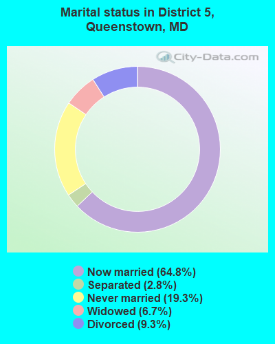
- Never married: 19.3%
- Now married: 64.8%
- Separated: 2.8%
- Widowed: 6.7%
- Divorced: 9.3%
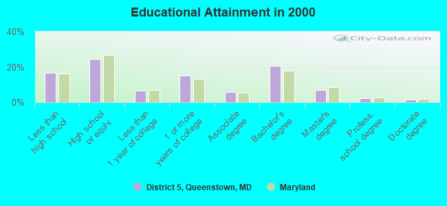
For population 25 years and over in District 5, Queenstown:
- High school or higher: 83.3%
- Bachelor's degree or higher: 31.4%
- Graduate or professional degree: 10.9%
- Unemployed: 3.2%
- Mean travel time to work (commute): 32.5 minutes
| Here: | 11.8 |
| Maryland average: | 12.7 |
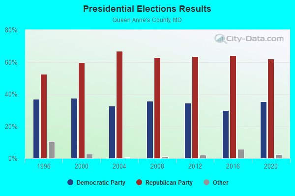
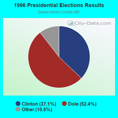
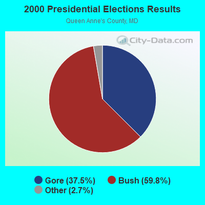
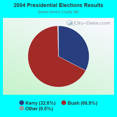
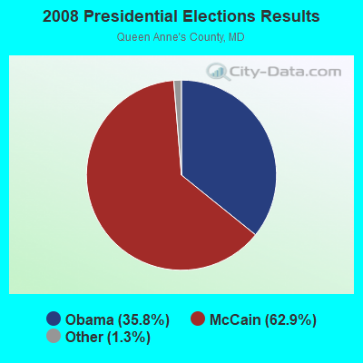
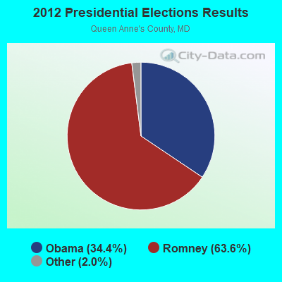
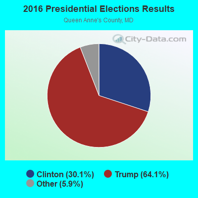

Graphs represent county-level data. Detailed 2008 Election Results
Religion statistics for District 5, Queenstown, MD (based on Queen Anne's County data)
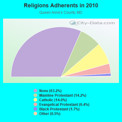
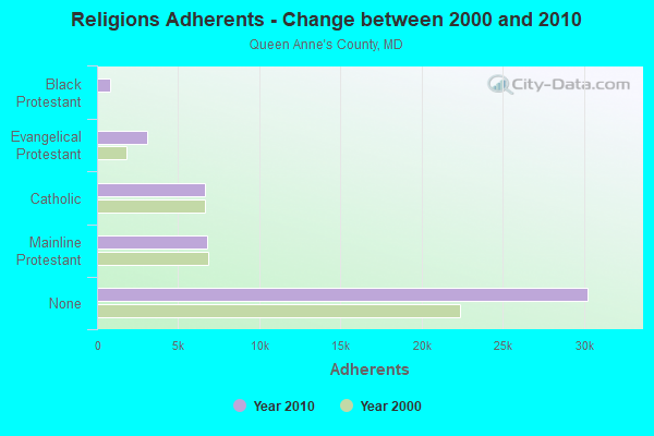
| Religion | Adherents | Congregations |
|---|---|---|
| Mainline Protestant | 6,786 | 31 |
| Catholic | 6,673 | 3 |
| Evangelical Protestant | 3,072 | 21 |
| Black Protestant | 805 | 5 |
| Other | 230 | 2 |
| None | 30,232 | - |
Food Environment Statistics:
| Here: | 2.36 / 10,000 pop. |
| State: | 1.96 / 10,000 pop. |
| This county: | 0.86 / 10,000 pop. |
| Maryland: | 1.22 / 10,000 pop. |
| Here: | 4.30 / 10,000 pop. |
| Maryland: | 2.05 / 10,000 pop. |
| Here: | 6.02 / 10,000 pop. |
| Maryland: | 5.40 / 10,000 pop. |
| This county: | 7.8% |
| Maryland: | 9.1% |
| Queen Anne's County: | 24.4% |
| Maryland: | 26.7% |
| Here: | 13.3% |
| Maryland: | 15.5% |
Strongest AM radio stations in District 5, Queenstown:
- WBIS (1190 AM; 50 kW; ANNAPOLIS, MD; Owner: NATIONS RADIO, LLC)
- WWLG (1370 AM; 50 kW; BALTIMORE, MD; Owner: M-10 BROADCASTING, INC.)
- WCBM (680 AM; 50 kW; BALTIMORE, MD; Owner: WCBM MARYLAND, INC.)
- WTEM (980 AM; 50 kW; WASHINGTON, DC; Owner: AMFM RADIO LICENSES, L.L.C.)
- WWGB (1030 AM; daytime; 50 kW; INDIAN HEAD, MD; Owner: GOOD BODY MEDIA, LLC)
- WBAL (1090 AM; 50 kW; BALTIMORE, MD; Owner: HEARST RADIO, INC.)
- WPGC (1580 AM; 50 kW; MORNINGSIDE, MD; Owner: INFINITY WPGC(AM), INC.)
- WGOP (700 AM; daytime; 25 kW; WALKERSVILLE, MD; Owner: BIRACH BROADCASTING CORPORATION)
- WTOP (1500 AM; 50 kW; WASHINGTON, DC; Owner: BONNEVILLE HOLDING COMPANY)
- WMET (1150 AM; 50 kW; GAITHERSBURG, MD; Owner: BELTWAY ACQUISITION CORPORATION)
- WVCH (740 AM; 50 kW; CHESTER, PA; Owner: WVCH COMMUNICATIONS, INC.)
- WNAV (1430 AM; 5 kW; ANNAPOLIS, MD; Owner: SAJAK BROADCASTING CORP.)
- WPEN (950 AM; 50 kW; PHILADELPHIA, PA; Owner: GREATER PHILADELPHIA RADIO, INC.)
Strongest FM radio stations in District 5, Queenstown:
- WRNR-FM (103.1 FM; GRASONVILLE, MD; Owner: EMPIRE BROADCASTING SYSTEM, INC.)
- WWMX (106.5 FM; BALTIMORE, MD; Owner: INFINITY RADIO OPERATIONS INC.)
- WIYY (97.9 FM; BALTIMORE, MD; Owner: HEARST RADIO, INC.)
- WLIF (101.9 FM; BALTIMORE, MD; Owner: INFINITY WLIF, INC.)
- WCEI-FM (96.7 FM; EASTON, MD; Owner: FIRST MEDIA RADIO, LLC)
- WPOC (93.1 FM; BALTIMORE, MD; Owner: CITICASTERS LICENSES, L.P.)
- WFSI (107.9 FM; ANNAPOLIS, MD; Owner: FAMILY STATIONS, INC.)
- WBZS-FM (92.7 FM; PRINCE FREDERICK, MD; Owner: MEGA COMMUNICATIONS OF PRINCE FREDERICK LICENSEE, LLC)
- WAAI (100.9 FM; HURLOCK, MD; Owner: MTS BROADCASTING, L.C.)
- WINX-FM (94.3 FM; CAMBRIDGE, MD; Owner: CWA BROADCASTING, INC.)
- WTDK (107.1 FM; FEDERALSBURG, MD; Owner: MTS BROADCASTING, L.C.)
TV broadcast stations around District 5, Queenstown:
- WMPT (Channel 22; ANNAPOLIS, MD; Owner: MARYLAND PUBLIC BROADCASTING COMMISSION)
- WBAL-TV (Channel 11; BALTIMORE, MD; Owner: WBAL HEARST-ARGYLE TV, INC. (CA CORP.))
- WMAR-TV (Channel 2; BALTIMORE, MD; Owner: SCRIPPS HOWARD BROADCASTING COMPANY)
- WBFF (Channel 45; BALTIMORE, MD; Owner: CHESAPEAKE TELEVISION LICENSEE, LLC)
- WNUV (Channel 54; BALTIMORE, MD; Owner: BALTIMORE (WNUV-TV) LICENSEE, INC.)
- W61BY (Channel 61; ANNAPOLIS, MD; Owner: ANNAPOLIS BROADCASTING COMPANY, INC.)
- W63BP (Channel 63; ANNAPOLIS, MD; Owner: ANNAPOLIS BROADCASTING COMPANY, INC.)
- WJZ-TV (Channel 13; BALTIMORE, MD; Owner: VIACOM INC.)
- WMDT (Channel 47; SALISBURY, MD; Owner: DELMARVA BROADCAST SERVICE GENERAL PARTNERSHIP)
- WUTB (Channel 24; BALTIMORE, MD; Owner: FOX TELEVISION STATIONS, INC.)
- WTSD-CA (Channel 14; WILMINGTON, DE; Owner: PRIORITY COMMUNICATIONS MINISTRIES, INC.)
- WMPB (Channel 67; BALTIMORE, MD; Owner: MARYLAND PUBLIC BROADCASTING COMMISSION)
- WBOC-TV (Channel 16; SALISBURY, MD; Owner: WBOC, INC.)
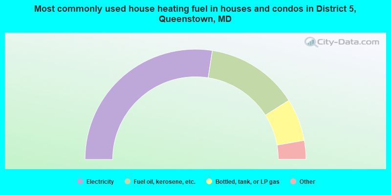
- 54.9%Electricity
- 27.1%Fuel oil, kerosene, etc.
- 12.5%Bottled, tank, or LP gas
- 3.1%Wood
- 1.2%Utility gas
- 0.8%Other fuel
- 0.4%No fuel used
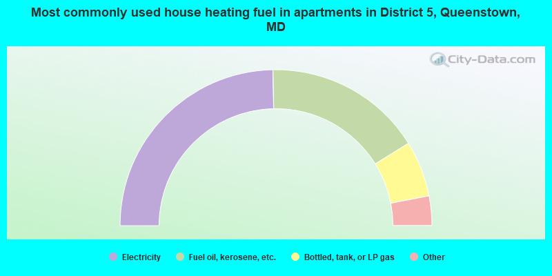
- 49.4%Electricity
- 32.9%Fuel oil, kerosene, etc.
- 11.6%Bottled, tank, or LP gas
- 2.6%Other fuel
- 2.4%Coal or coke
- 0.6%Wood
- 0.6%No fuel used
District 5, Queenstown compared to Maryland state average:
- Unemployed percentage significantly below state average.
- Black race population percentage below state average.
- Hispanic race population percentage significantly below state average.
- Median age significantly above state average.
- Foreign-born population percentage significantly below state average.
- Renting percentage below state average.
- Length of stay since moving in significantly above state average.
- Number of rooms per house significantly below state average.
- House age significantly below state average.
District 5, Queenstown on our top lists:
- #16 on the list of "Top 101 cities with largest percentage of females in occupations: transportation, tourism, and lodging attendants (population 5,000+)"
- #34 on the list of "Top 101 cities with largest percentage of males in occupations: other food preparation and serving workers including supervisors (population 5,000+)"
- #37 on the list of "Top 101 cities with largest percentage of females in industries: groceries and related products merchant wholesalers (population 5,000+)"
- #38 on the list of "Top 101 cities with largest percentage of females in occupations: financial managers (population 5,000+)"
- #42 on the list of "Top 101 cities with largest percentage of males in occupations: mathematical science occupations (population 5,000+)"
- #42 on the list of "Top 101 cities with largest percentage of males in industries: apparel, fabrics, and notions merchant wholesalers (population 5,000+)"
- #46 on the list of "Top 101 cities with largest percentage of males in occupations: fishing and hunting, and forest and logging workers (population 5,000+)"
- #50 on the list of "Top 101 cities with largest percentage of females in occupations: advertising, marketing, promotions, public relations, and sales managers (population 5,000+)"
- #53 on the list of "Top 101 cities with largest percentage of females in industries: air transportation (population 5,000+)"
- #55 on the list of "Top 101 cities with largest percentage of females in industries: hardware, plumbing and heating equipment, and supplies merchant wholesalers (population 5,000+)"
- #79 on the list of "Top 101 cities with largest percentage of males in industries: groceries and related products merchant wholesalers (population 5,000+)"
- #85 on the list of "Top 101 cities with largest percentage of males in industries: hardware, plumbing and heating equipment, and supplies merchant wholesalers (population 5,000+)"
- #95 on the list of "Top 101 cities with largest percentage of females in industries: lumber and other construction materials merchant wholesalers (population 5,000+)"
- #60 on the list of "Top 101 counties with the highest percentage of residents that drank alcohol in the past 30 days"
- #63 on the list of "Top 101 counties with the highest percentage of residents that visited a dentist within the past year"
- #72 on the list of "Top 101 counties with the highest percentage of residents that smoked 100+ cigarettes in their lives"