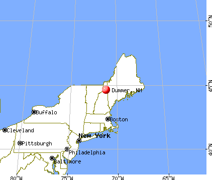
Dummer, New Hampshire
Submit your own pictures of this town and show them to the world
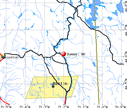
- OSM Map
- General Map
- Google Map
- MSN Map
Population change since 2000: -1.6%
 |
| Males: 162 | |
| Females: 142 |
| Median resident age: | 48.3 years |
| New Hampshire median age: | 43.9 years |
Zip codes: 03588.
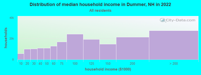
| Dummer: | $53,355 |
| NH: | $89,992 |
Estimated per capita income in 2022: $32,369 (it was $16,754 in 2000)
Dummer town income, earnings, and wages data
Estimated median house or condo value in 2022: $210,099 (it was $80,800 in 2000)
| Dummer: | $210,099 |
| NH: | $384,700 |
Mean prices in 2022: all housing units: $223,643; detached houses: $241,655; townhouses or other attached units: $431,348; in 2-unit structures: $202,937; in 3-to-4-unit structures: $301,182; in 5-or-more-unit structures: $411,054; mobile homes: $86,091
Detailed information about poverty and poor residents in Dummer, NH
Compare current foreclosures near Dummer, NH:
| Photo | Address | Area | Beds / Baths | Price | Details |
|---|---|---|---|---|---|

|
#1
Willard St
Berlin, NH 03570
|
1,183 sq. feet
|
1 baths 3 beds |
show details | |

|
#2
Willard St
Berlin, NH 03570
|
1,664 sq. feet
|
1 baths 3 beds |
show details | |

|
#3
Montgomery Rd
Groveton, NH 03582
|
- sq. feet
|
- baths - beds |
show details | |

|
#4
Hill Rd
Milan, NH 03588
|
- sq. feet
|
- baths - beds |
show details | |

|
#5
Sweden St
Berlin, NH 03570
|
- sq. feet
|
- baths - beds |
show details | |

|
#6
Church St
Berlin, NH 03570
|
- sq. feet
|
- baths - beds |
show details | |

|
#7
Cascade St
Berlin, NH 03570
|
- sq. feet
|
- baths - beds |
show details | |

|
Check over 1 million property listings on Foreclosure.com!
|
browse all offers | |||

- 29797.7%White alone
- 62.0%Two or more races
- 10.3%Hispanic
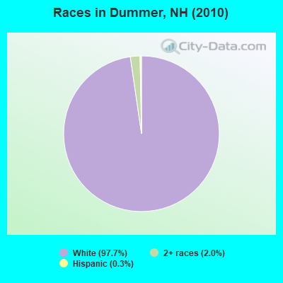
Races in Dummer detailed stats: ancestries, foreign born residents, place of birth
According to our research of New Hampshire and other state lists, there was 1 registered sex offender living in Dummer, New Hampshire as of May 17, 2024.
The ratio of all residents to sex offenders in Dummer is 304 to 1.
 Recent articles from our blog. Our writers, many of them Ph.D. graduates or candidates, create easy-to-read articles on a wide variety of topics.

 | Commuting from southern NH to Ipswich, MA (4 replies) |
| Relocating to New Hampshire (25 replies) |
| What town in New Hampshire most closely represents or reminds you of small town America? (857 replies) |
| New Hampshire's Most Affordable Towns (11 replies) |
| moving to the great north woods (8 replies) |
| Just wondering.... any towns strongly Republican or Democrat? (90 replies) |
Latest news from Dummer, NH collected exclusively by city-data.com from local newspapers, TV, and radio stations
Ancestries: French (38.2%), English (28.2%), French Canadian (20.7%), Irish (17.8%), Norwegian (8.1%), Italian (4.9%).
Current Local Time: EST time zone
Incorporated in 1848
Elevation: 1197 feet
Land area: 47.7 square miles.
Population density: 6.4 people per square mile (very low).
8 residents are foreign born (1.6% North America, 1.0% Asia).
| This town: | 2.6% |
| New Hampshire: | 4.4% |
| Dummer town: | 1.2% ($942) |
| New Hampshire: | 2.3% ($2,946) |
Nearest city with pop. 50,000+: Portland, ME  (84.3 miles , pop. 64,249).
Nearest city with pop. 200,000+: Boston, MA (161.3 miles , pop. 589,141).
Nearest city with pop. 1,000,000+: Bronx, NY (294.4 miles , pop. 1,332,650).
Nearest cities:
), ), ), ), ), ), Latitude: 44.65 N, Longitude: 71.27 W
Area code commonly used in this area: 603

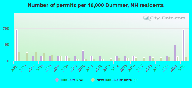
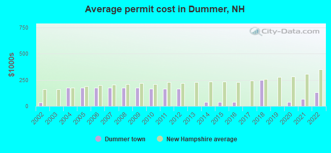
Single-family new house construction building permits:
- 2022: 6 buildings, average cost: $132,500
- 2021: 3 buildings, average cost: $70,300
- 2020: 1 building, cost: $38,400
- 2018: 1 building, cost: $249,800
- 2016: 1 building, cost: $40,000
- 2015: 1 building, cost: $40,000
- 2014: 1 building, cost: $40,000
- 2012: 1 building, cost: $165,900
- 2011: 1 building, cost: $165,900
- 2010: 2 buildings, average cost: $165,900
- 2009: 1 building, cost: $175,000
- 2008: 1 building, cost: $175,000
- 2007: 1 building, cost: $175,000
- 2006: 1 building, cost: $175,000
- 2005: 1 building, cost: $175,000
- 2004: 1 building, cost: $175,000
- 2002: 6 buildings, average cost: $36,000
| Here: | 3.0% |
| New Hampshire: | 2.5% |
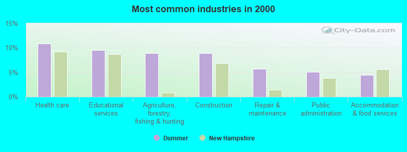
- Health care (10.8%)
- Educational services (9.6%)
- Agriculture, forestry, fishing & hunting (8.9%)
- Construction (8.9%)
- Repair & maintenance (5.7%)
- Public administration (5.1%)
- Accommodation & food services (4.5%)
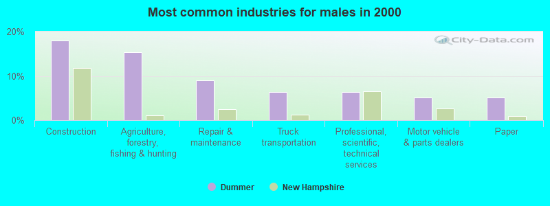
- Construction (17.9%)
- Agriculture, forestry, fishing & hunting (15.4%)
- Repair & maintenance (9.0%)
- Truck transportation (6.4%)
- Professional, scientific, technical services (6.4%)
- Motor vehicle & parts dealers (5.1%)
- Paper (5.1%)
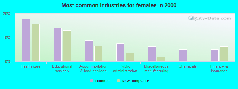
- Health care (17.7%)
- Educational services (13.9%)
- Accommodation & food services (8.9%)
- Public administration (7.6%)
- Miscellaneous manufacturing (6.3%)
- Chemicals (5.1%)
- Finance & insurance (5.1%)
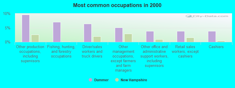
- Other production occupations, including supervisors (9.6%)
- Fishing, hunting, and forestry occupations (7.0%)
- Driver/sales workers and truck drivers (6.4%)
- Other management occupations, except farmers and farm managers (5.1%)
- Other office and administrative support workers, including supervisors (3.8%)
- Retail sales workers, except cashiers (3.8%)
- Cashiers (3.8%)
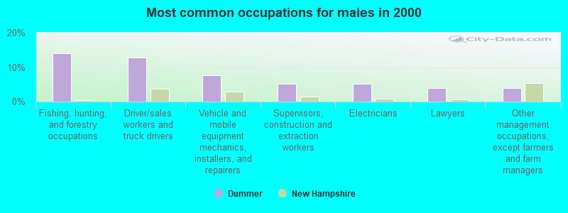
- Fishing, hunting, and forestry occupations (14.1%)
- Driver/sales workers and truck drivers (12.8%)
- Vehicle and mobile equipment mechanics, installers, and repairers (7.7%)
- Supervisors, construction and extraction workers (5.1%)
- Electricians (5.1%)
- Lawyers (3.8%)
- Other management occupations, except farmers and farm managers (3.8%)
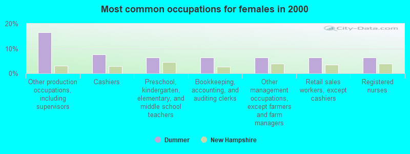
- Other production occupations, including supervisors (16.5%)
- Cashiers (7.6%)
- Preschool, kindergarten, elementary, and middle school teachers (6.3%)
- Bookkeeping, accounting, and auditing clerks (6.3%)
- Other management occupations, except farmers and farm managers (6.3%)
- Retail sales workers, except cashiers (6.3%)
- Registered nurses (6.3%)
Average climate in Dummer, New Hampshire
Based on data reported by over 4,000 weather stations


(lower is better)
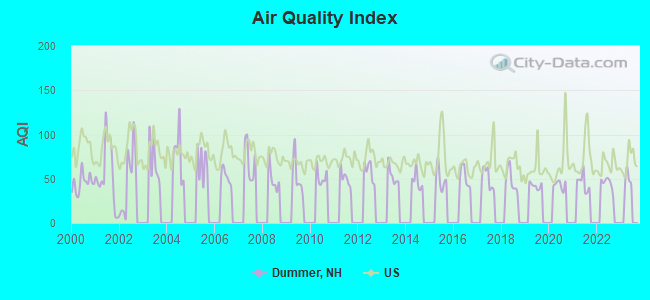
Air Quality Index (AQI) level in 2022 was 45.0. This is significantly better than average.
| City: | 45.0 |
| U.S.: | 72.6 |
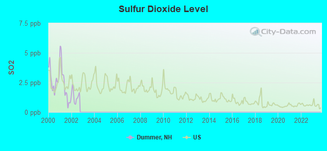
Sulfur Dioxide (SO2) [ppb] level in 2002 was 1.38. This is about average. Closest monitor was 10.9 miles away from the city center.
| City: | 1.38 |
| U.S.: | 1.51 |
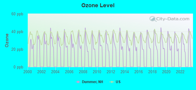
Ozone [ppb] level in 2022 was 27.7. This is better than average. Closest monitor was 12.8 miles away from the city center.
| City: | 27.7 |
| U.S.: | 33.3 |
Earthquake activity:
Dummer-area historical earthquake activity is significantly above New Hampshire state average. It is 74% smaller than the overall U.S. average.On 4/20/2002 at 10:50:47, a magnitude 5.3 (5.3 ML, Depth: 3.0 mi, Class: Moderate, Intensity: VI - VII) earthquake occurred 120.0 miles away from the city center
On 4/20/2002 at 10:50:47, a magnitude 5.2 (5.2 MB, 4.2 MS, 5.2 MW, 5.0 MW) earthquake occurred 121.1 miles away from Dummer center
On 10/7/1983 at 10:18:46, a magnitude 5.3 (5.1 MB, 5.3 LG, 5.1 ML) earthquake occurred 159.5 miles away from Dummer center
On 10/16/2012 at 23:12:25, a magnitude 4.7 (4.7 ML, Depth: 10.0 mi, Class: Light, Intensity: IV - V) earthquake occurred 79.0 miles away from the city center
On 1/19/1982 at 00:14:42, a magnitude 4.7 (4.5 MB, 4.7 MD, 4.5 LG) earthquake occurred 81.2 miles away from Dummer center
On 8/21/1996 at 07:54:14, a magnitude 3.8 (3.8 LG, 3.6 LG, Depth: 6.2 mi, Class: Light, Intensity: II - III) earthquake occurred 32.5 miles away from the city center
Magnitude types: regional Lg-wave magnitude (LG), body-wave magnitude (MB), duration magnitude (MD), local magnitude (ML), surface-wave magnitude (MS), moment magnitude (MW)
Natural disasters:
The number of natural disasters in Coos County (22) is greater than the US average (15).Major Disasters (Presidential) Declared: 11
Emergencies Declared: 9
Causes of natural disasters: Floods: 9, Storms: 9, Hurricanes: 3, Snows: 2, Winter Storms: 2, Blizzard: 1, Ice Storm: 1, Snowfall: 1, Snowstorm: 1, Tropical Storm: 1, Wind: 1, Other: 1 (Note: some incidents may be assigned to more than one category).
Hospitals and medical centers near Dummer:
- COOS COUNTY NURSING HOME (Nursing Home, about 12 miles away; BERLIN, NH)
- SAINT VINCENT DE PAUL REHABILITATION AND NURSING CTR (Nursing Home, about 12 miles away; BERLIN, NH)
- ANDROSCOGGIN VLY HOME HEALTH (Home Health Center, about 13 miles away; BERLIN, NH)
- ANDROSCOGGIN VALLEY HOSPITAL Critical Access Hospitals (about 13 miles away; BERLIN, NH)
located in Dummer:
Colleges/universities with over 2000 students nearest to Dummer:
- University of Maine at Farmington (about 56 miles; Farmington, ME; Full-time enrollment: 2,036)
- Plymouth State University (about 66 miles; Plymouth, NH; FT enrollment: 4,838)
- Saint Joseph's College of Maine (about 70 miles; Standish, ME; FT enrollment: 2,010)
- University of Maine at Augusta (about 76 miles; Augusta, ME; FT enrollment: 3,204)
- Norwich University (about 78 miles; Northfield, VT; FT enrollment: 4,221)
- Dartmouth College (about 83 miles; Hanover, NH; FT enrollment: 6,030)
- University of Southern Maine (about 85 miles; Portland, ME; FT enrollment: 6,647)
Points of interest:
Church in Dummer: Dummer United Methodist Church (A). Display/hide its location on the map
Lakes, reservoirs, and swamps: Dummer Ponds (A), Mud Pond (B), Sessions Pond (C), Pontook Reservoir (D), Goose Pond (E). Display/hide their locations on the map
Streams, rivers, and creeks: Sessions Brook (A), Robbins Brook (B), Pond Brook (C), Newell Brook (D), Lord Brook (E), Jodrie Brook (F), Island Brook (G). Display/hide their locations on the map
| This town: | 2.4 people |
| New Hampshire: | 2.5 people |
| This town: | 71.3% |
| Whole state: | 66.3% |
| This town: | 6.2% |
| Whole state: | 8.3% |
Likely homosexual households (counted as self-reported same-sex unmarried-partner households)
- Lesbian couples: 0.8% of all households
- Gay men: 0.0% of all households
| This town: | 6.7% |
| Whole state: | 6.5% |
| This town: | 2.3% |
| Whole state: | 2.8% |
For population 15 years and over in Dummer:
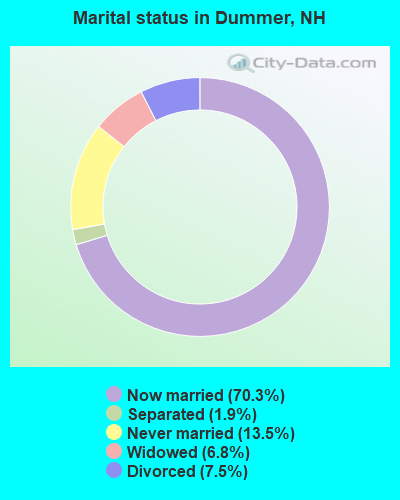
- Never married: 13.5%
- Now married: 70.3%
- Separated: 1.9%
- Widowed: 6.8%
- Divorced: 7.5%
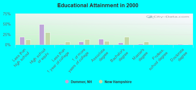
For population 25 years and over in Dummer:
- High school or higher: 81.0%
- Bachelor's degree or higher: 8.5%
- Graduate or professional degree: 3.6%
- Unemployed: 8.2%
- Mean travel time to work (commute): 27.1 minutes
| Here: | 10.7 |
| New Hampshire average: | 10.9 |
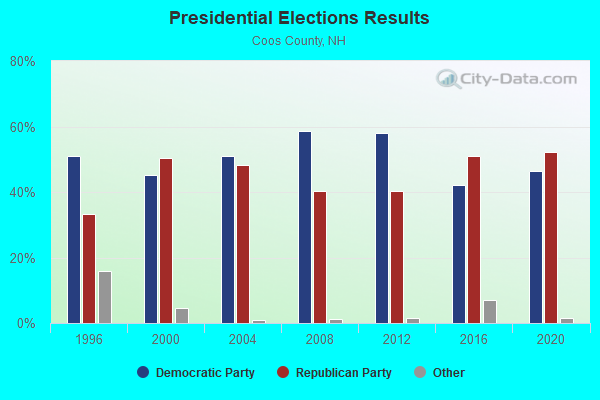
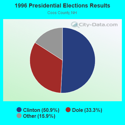
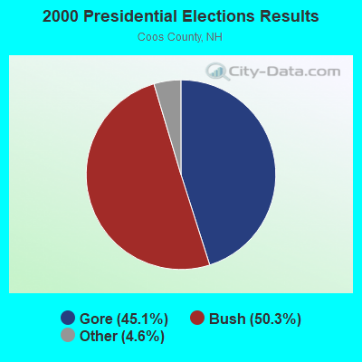
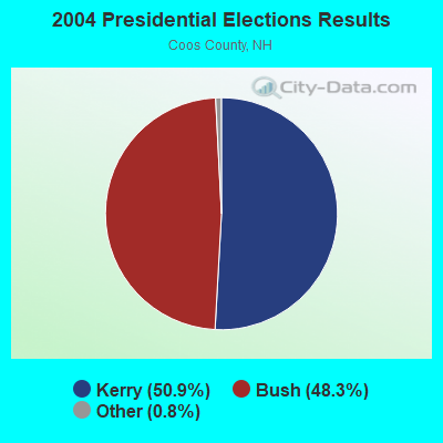
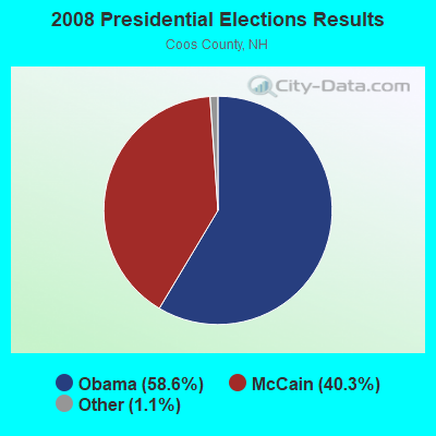
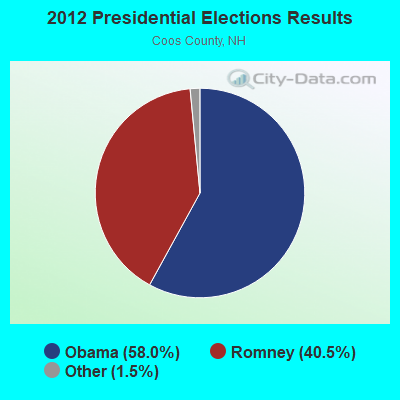
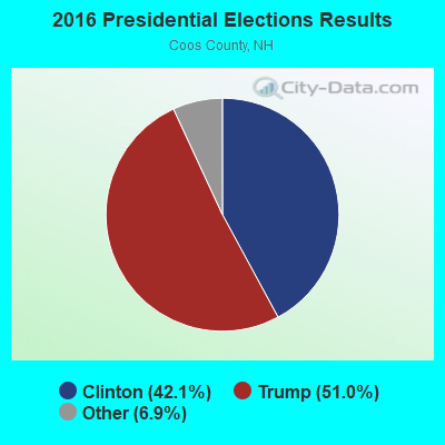
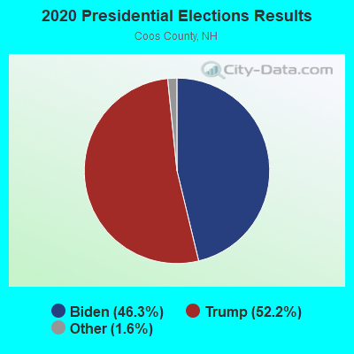
Graphs represent county-level data. Detailed 2008 Election Results
Religion statistics for Dummer, NH (based on Coos County data)
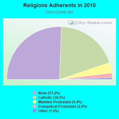
| Religion | Adherents | Congregations |
|---|---|---|
| Catholic | 12,710 | 5 |
| Mainline Protestant | 2,105 | 23 |
| Evangelical Protestant | 966 | 14 |
| Other | 323 | 7 |
| Orthodox | 26 | 1 |
| None | 16,925 | - |
Food Environment Statistics:
| Coos County: | 4.33 / 10,000 pop. |
| State: | 2.14 / 10,000 pop. |
| Coos County: | 0.93 / 10,000 pop. |
| State: | 1.78 / 10,000 pop. |
| Coos County: | 9.28 / 10,000 pop. |
| State: | 4.02 / 10,000 pop. |
| Coos County: | 12.68 / 10,000 pop. |
| New Hampshire: | 9.70 / 10,000 pop. |
| Here: | 9.7% |
| New Hampshire: | 7.6% |
| Coos County: | 26.9% |
| State: | 24.4% |
| Coos County: | 9.7% |
| State: | 15.9% |
Strongest AM radio stations in Dummer:
- WTME (780 AM; 10 kW; RUMFORD, ME; Owner: MOUNTAIN VALLEY BROADCASTING, INC.)
- WMOU (1230 AM; 1 kW; BERLIN, NH; Owner: JERICHO BROADCASTING COMPANY, L.L.C.)
- WCHP (760 AM; 35 kW; CHAMPLAIN, NY; Owner: CHAMPLAIN RADIO, INC.)
- WRKO (680 AM; 50 kW; BOSTON, MA; Owner: ENTERCOM BOSTON LICENSE, LLC)
- WEEI (850 AM; 50 kW; BOSTON, MA; Owner: ENTERCOM BOSTON LICENSE, LLC)
- WNNZ (640 AM; 50 kW; WESTFIELD, MA; Owner: CLEAR CHANNEL BROADCASTING LICENSES, INC.)
- WCRN (830 AM; 50 kW; WORCESTER, MA; Owner: CARTER BROADCASTING CORPORATION)
- WMTW (870 AM; 10 kW; GORHAM, ME; Owner: RADIO PARTNERS OF MAINE, L.P.)
- WBZ (1030 AM; 50 kW; BOSTON, MA; Owner: INFINITY BROADCASTING OPERATIONS, INC.)
- WGY (810 AM; 50 kW; SCHENECTADY, NY; Owner: CLEAR CHANNEL BROADCASTING LICENSES, INC.)
- WTWN (1100 AM; daytime; 5 kW; WELLS RIVER, VT; Owner: PUFFER BROADCASTING, INC.)
- WICY (1490 AM; 50 kW; MALONE, NY; Owner: CARTIER COMMUNICATIONS INC.)
- WKOX (1200 AM; 50 kW; FRAMINGHAM, MA; Owner: CAPSTAR TX LIMITED PARTNERSHIP)
Strongest FM radio stations in Dummer:
- WPKQ (103.7 FM; NORTH CONWAY, NH; Owner: CITADEL BROADCASTING COMPANY)
- WHOM (94.9 FM; MT. WASHINGTON, NH; Owner: CITADEL BROADCASTING COMPANY)
- WGMT (97.7 FM; LYNDON, VT; Owner: VERMONT BROADCAST ASSOCIATES, INC.)
- WLOB-FM (96.3 FM; RUMFORD, ME; Owner: ATLANTIC COAST RADIO, LLC)
- WMTK (106.3 FM; LITTLETON, NH; Owner: VERMONT BROADCAST ASSOCIATES, INC.)
- WTBM (100.7 FM; MEXICO, ME; Owner: MOUNTAIN VALLEY BROADCASTING, INC.)
- WXXS (102.3 FM; LANCASTER, NH; Owner: BARRY P. LUNDERVILLE)
- WTOS-FM (105.1 FM; SKOWHEGAN, ME; Owner: CAPSTAR TX LIMITED PARTNERSHIP)
- WVFM (105.7 FM; CAMPTON, NH; Owner: DEVON BROADCASTING COMPANY, INC.)
- WSCY (106.9 FM; MOULTONBOROUGH, NH; Owner: NORTHEAST COMMUNICATIONS CORPORATION)
- WMEA (90.1 FM; PORTLAND, ME; Owner: MAINE PUBLIC BROADCASTING CORPORATION)
- WCKJ (90.5 FM; ST. JOHNSBURY, VT; Owner: CHRISTIAN MINISTRIES, INC.)
- WEVC (107.1 FM; GORHAM, NH; Owner: NEW HAMPSHIRE PUBLIC RADIO, INCORPORATED)
- National Bridge Inventory (NBI) Statistics
- 2Number of bridges
- 10ft / 3.2mTotal length
- $6,284,000Total costs
- 1,384Total average daily traffic
- 55Total average daily truck traffic
- 2,047Total future (year 2042) average daily traffic
FCC Registered Antenna Towers:
5- Megan McGuire, 146 Ferry Rd (Lat: 44.651750 Lon: -71.207667), Type: 59.7, Structure height: 33007 m, Overall height: 57.9 m, Registrant: Bmb Vertical Assets, LLC C/O Black Diamond Consultants, Inc., Mjmcguire@blackdiamond.Net, , 57 Gardi-ner, Phone: (207) 582-0056
- Megan McGuire, 146 Ferry Rd (Lat: 44.651750 Lon: -71.207667), Type: 59.7, Structure height: 33007 m, Overall height: 57.9 m, Registrant: Bmb Vertical Assets, LLC C/O Black Diamond Consultants, Inc., Mjmcguire@blackdiamond.Net, , 57 Gardi-ner, Phone: (207) 582-0056
- Megan McGuire, 146 Ferry Rd (Lat: 44.651750 Lon: -71.207667), Type: 59.7, Structure height: 33007 m, Overall height: 57.9 m, Licensee ID: L, Registrant: Bmb Vertical Assets, LLC C/O Black Diamond Consultants, Inc., Mjmcguire@blackdiamond.Net, , 57 Gardi-ner, Phone: (207) 582-0056
- Megan McGuire, 146 Ferry Rd (Lat: 44.651750 Lon: -71.207667), Type: 59.7, Structure height: 33007 m, Overall height: 57.9 m, Registrant: Bmb Vertical Assets, LLC C/O Black Diamond Consultants, Inc., Mjmcguire@blackdiamond.Net, , 57 Gardi-ner, Phone: (207) 582-0056
- RHODA CASTANEDA, 146 Ferry Rd (Lat: 44.651750 Lon: -71.207667), Type: 59.7, Structure height: 33007 m, Overall height: 57.9 m, Registrant: Vertical Bridge Towers Iii, LLC, Fcc-Faa@verticalbridge.Com, Suite 200, Boca -Raton, Phone: (561) 406-4015
FCC Registered Amateur Radio Licenses:
1- Call Sign: N1WAZ, Licensee ID: L00688067, Grant Date: 04/12/2007, Expiration Date: 04/12/2017, Cancellation Date: 04/13/2019, Certifier: Roger O Meserve, Registrant: Roger O Meserve, 151 Blake Road, Dummer, NH 03588
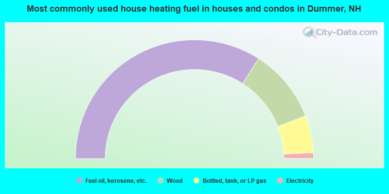
- 68.2%Fuel oil, kerosene, etc.
- 20.2%Wood
- 10.1%Bottled, tank, or LP gas
- 1.6%Electricity
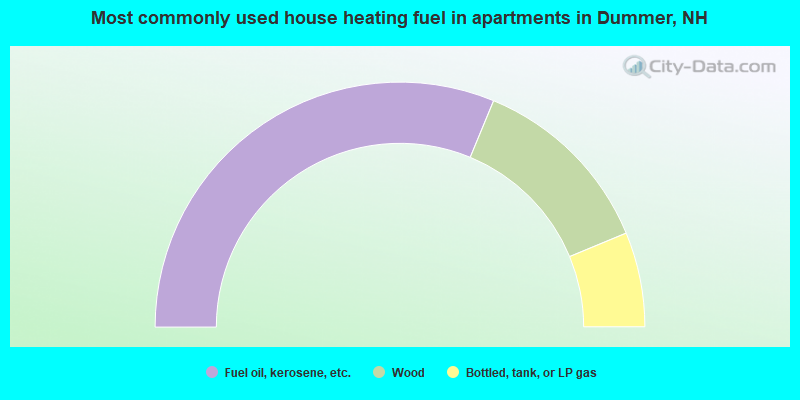
- 62.5%Fuel oil, kerosene, etc.
- 25.0%Wood
- 12.5%Bottled, tank, or LP gas
Dummer compared to New Hampshire state average:
- Median household income below state average.
- Median house value below state average.
- Black race population percentage significantly below state average.
- Hispanic race population percentage significantly below state average.
- Median age above state average.
- Foreign-born population percentage significantly below state average.
- Renting percentage significantly below state average.
- Length of stay since moving in significantly above state average.
- Number of rooms per house significantly below state average.
- House age significantly below state average.
- Number of college students below state average.
- Percentage of population with a bachelor's degree or higher significantly below state average.