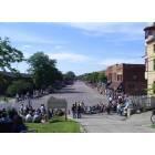
Dunnville, Kentucky
Submit your own pictures of this place and show them to the world
- OSM Map
- General Map
- Google Map
- MSN Map

| Males: 1,295 | |
| Females: 1,331 |
| Median resident age: | 35.5 years |
| Kentucky median age: | 35.9 years |
Zip code: 42539
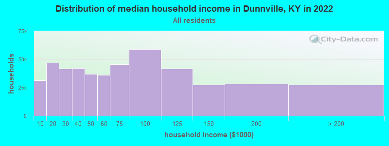
| Dunnville: | $33,247 |
| KY: | $59,341 |
Estimated per capita income in 2022: $19,298 (it was $10,662 in 2000)
Dunnville CCD income, earnings, and wages data
Estimated median house or condo value in 2022: $104,817 (it was $34,900 in 2000)
| Dunnville: | $104,817 |
| KY: | $196,300 |
Mean prices in 2022: all housing units: $145,827; detached houses: $175,931; townhouses or other attached units: $75,954; mobile homes: $51,373
Detailed information about poverty and poor residents in Dunnville, KY
Compare current foreclosures near Dunnville, KY:
| Photo | Address | Area | Beds / Baths | Price | Details |
|---|---|---|---|---|---|

|
#1
Riffe Creek Rd
Dunnville, KY 42528
|
- sq. feet
|
- baths - beds |
show details | |

|
#2
Floyd Switch Rd
Eubank, KY 42567
|
2,488 sq. feet
|
2 baths 3 beds |
show details | |

|
#3
A F White Rd
Columbia, KY 42728
|
1,776 sq. feet
|
1 baths 2 beds |
show details | |

|
#4
Conner Ave
Liberty, KY 42539
|
1,900 sq. feet
|
2 baths 4 beds |
show details | |

|
#5
Stanford St
Science Hill, KY 42553
|
1,194 sq. feet
|
1 baths 3 beds |
show details | |

|
#6
Bethlehem Ridge Rd
Science Hill, KY 42553
|
1,344 sq. feet
|
1 baths 3 beds |
show details | |

|
#7
Allen Schoolhouse Rd
Columbia, KY 42728
|
936 sq. feet
|
1 baths 2 beds |
show details | |

|
#8
High St
Russell Springs, KY 42642
|
960 sq. feet
|
1 baths 3 beds |
show details | |

|
#9
Shepherd Dr
Russell Springs, KY 42642
|
1,440 sq. feet
|
1 baths 3 beds |
show details | |

|
#10
W Highway 80
Somerset, KY 42503
|
1,824 sq. feet
|
2 baths 3 beds |
show details |
| Photo | Address | Area | Beds / Baths | Price | Details |
|---|---|---|---|---|---|

|
#11
W Ky 70
Liberty, KY 42539
|
1,680 sq. feet
|
3 baths 3 beds |
show details | |

|
#12
Ky 1547
Liberty, KY 42539
|
2,476 sq. feet
|
4 baths 3 beds |
show details | |

|
#13
Hall Ridge Rd
Science Hill, KY 42553
|
1,568 sq. feet
|
2 baths 3 beds |
show details | |

|
#14
Westgate Dr
Somerset, KY 42503
|
1,092 sq. feet
|
1 baths 3 beds |
show details | |

|
#15
Hearthside Dr
Somerset, KY 42503
|
1,536 sq. feet
|
2 baths 3 beds |
show details | |

|
#16
Highway 1676
Science Hill, KY 42553
|
1,320 sq. feet
|
2 baths 3 beds |
show details | |

|
#17
Highway 196
Nancy, KY 42544
|
1,341 sq. feet
|
1 baths 3 beds |
show details | |

|
#18
Lily Creek Resort Rd
Jamestown, KY 42629
|
1,900 sq. feet
|
2 baths 3 beds |
show details | |

|
#19
E Highway 1248
Somerset, KY 42503
|
972 sq. feet
|
1 baths 2 beds |
show details | |

|
#20
Sunshine Ln
Nancy, KY 42544
|
1,280 sq. feet
|
2 baths 3 beds |
show details |
| Photo | Address | Area | Beds / Baths | Price | Details |
|---|---|---|---|---|---|

|
#21
Pine Tree Rd
Nancy, KY 42544
|
1,300 sq. feet
|
1 baths 3 beds |
show details | |

|
#22
Anita Ln
Somerset, KY 42503
|
624 sq. feet
|
1 baths 2 beds |
show details | |

|
#23
Lakeway Dr
Russell Springs, KY 42642
|
1,398 sq. feet
|
1 baths 3 beds |
show details | |

|
#24
Ringgold Rd
Somerset, KY 42503
|
2,001 sq. feet
|
2 baths 4 beds |
show details | |

|
#25
Cooper Ridge Rd
Columbia, KY 42728
|
800 sq. feet
|
1 baths 3 beds |
show details | |

|
#26
Lower Brush Creek Rd
Liberty, KY 42539
|
1,892 sq. feet
|
2 baths 2 beds |
show details | |

|
#27
E Ky 70
Liberty, KY 42539
|
1,168 sq. feet
|
1 baths 2 beds |
show details | |

|
#28
Wilson Ridge Rd
Science Hill, KY 42553
|
720 sq. feet
|
2 baths 5 beds |
show details | |

|
#29
Carmicle St
Liberty, KY 42539
|
1,016 sq. feet
|
2 baths 3 beds |
show details | |

|
#30
Jericho Rd
Russell Springs, KY 42642
|
- sq. feet
|
1 baths 3 beds |
show details |
| Photo | Address | Area | Beds / Baths | Price | Details |
|---|---|---|---|---|---|

|
#31
Womack St
Russell Springs, KY 42642
|
- sq. feet
|
1 baths 3 beds |
show details | |

|
#32
Damron Creek Rd
Russell Springs, KY 42642
|
- sq. feet
|
1 baths 3 beds |
show details | |

|
#33
Andy Spencer Rd
Eubank, KY 42567
|
- sq. feet
|
2 baths 3 beds |
show details | |

|
#34
Ky Highway 70 W
Eubank, KY 42567
|
- sq. feet
|
2 baths 3 beds |
show details | |

|
#35
Freedom Church Rd
Russell Springs, KY 42642
|
- sq. feet
|
- baths - beds |
show details | |

|
#36
Ringgold Rd
Somerset, KY 42503
|
- sq. feet
|
- baths - beds |
show details | |

|
#37
Belden Ave
Liberty, KY 42539
|
- sq. feet
|
- baths - beds |
show details | |

|
#38
Margaret Ln
Liberty, KY 42539
|
- sq. feet
|
- baths - beds |
show details | |

|
#39
Carlos Foley Rd
Russell Springs, KY 42642
|
- sq. feet
|
- baths - beds |
show details | |

|
#40
Moxley Rd
Liberty, KY 42539
|
- sq. feet
|
- baths - beds |
show details |
| Photo | Address | Area | Beds / Baths | Price | Details |
|---|---|---|---|---|---|

|
#41
Hillside Ct
Somerset, KY 42503
|
- sq. feet
|
- baths - beds |
show details | |

|
#42
Randalls Way
Somerset, KY 42503
|
- sq. feet
|
- baths - beds |
show details | |

|
#43
L Stringer Rd
Somerset, KY 42503
|
- sq. feet
|
- baths - beds |
show details | |

|
#44
R Grider Rd
Russell Springs, KY 42642
|
- sq. feet
|
- baths - beds |
show details | |

|
#45
Johnny Dr
Science Hill, KY 42553
|
- sq. feet
|
- baths - beds |
show details | |

|
#46
Spruce Pine Rd
Columbia, KY 42728
|
2,080 sq. feet
|
- baths - beds |
show details | |

|
#47
Molen St
Science Hill, KY 42553
|
- sq. feet
|
- baths - beds |
show details | |

|
#48
White Oak Dr
Nancy, KY 42544
|
- sq. feet
|
- baths - beds |
show details | |

|
#49
Shugars Hill Rd
Liberty, KY 42539
|
- sq. feet
|
- baths - beds |
show details | |

|
Check over 1 million property listings on Foreclosure.com!
|
browse all offers | |||

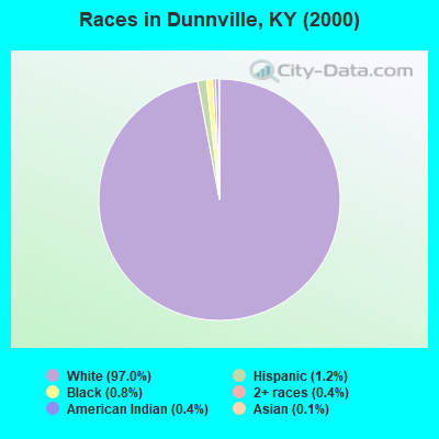
- 2,42097.0%White alone
- 291.2%Hispanic
- 210.8%Black alone
- 100.4%American Indian alone
- 110.4%Two or more races
- 30.1%Asian alone
- 10.04%Native Hawaiian and Other
Pacific Islander alone
Races in Dunnville detailed stats: ancestries, foreign born residents, place of birth
According to our research of Kentucky and other state lists, there was 1 registered sex offender living in Dunnville, Kentucky as of May 25, 2024.
The ratio of all residents to sex offenders in Dunnville is 2,626 to 1.
The ratio of registered sex offenders to all residents in this city is much lower than the state average.
 Recent articles from our blog. Our writers, many of them Ph.D. graduates or candidates, create easy-to-read articles on a wide variety of topics.
Current Local Time: EST time zone
Land area: 80.2 square miles.
Population density: 33 people per square mile (very low).

| Dunnville CCD: | 0.8% ($267) |
| Kentucky: | 0.8% ($610) |
Nearest city with pop. 50,000+: Fayette, KY  (63.5 miles , pop. 260,512).
Nearest city with pop. 1,000,000+: Chicago, IL (353.8 miles , pop. 2,896,016).
Nearest cities:
), ), ), ), ), )Latitude: 37.18 N, Longitude: 84.94 W
Area code commonly used in this area: 606

| Here: | 3.8% |
| Kentucky: | 3.8% |
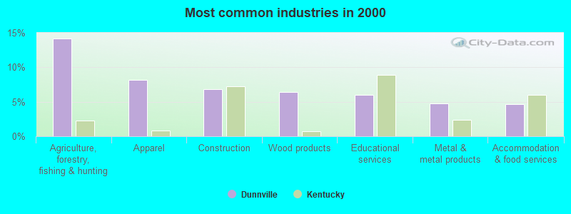
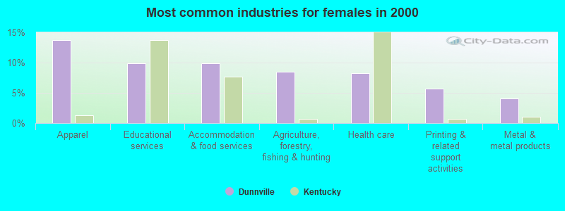
- Agriculture, forestry, fishing & hunting (14.2%)
- Apparel (8.2%)
- Construction (6.8%)
- Wood products (6.5%)
- Educational services (6.0%)
- Metal & metal products (4.8%)
- Accommodation & food services (4.6%)
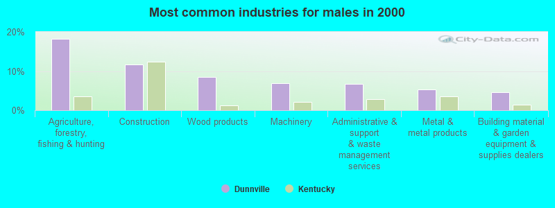
- Agriculture, forestry, fishing & hunting (18.2%)
- Construction (11.6%)
- Wood products (8.5%)
- Machinery (7.0%)
- Administrative & support & waste management services (6.8%)
- Metal & metal products (5.2%)
- Building material & garden equipment & supplies dealers (4.6%)
- Apparel (13.7%)
- Educational services (9.9%)
- Accommodation & food services (9.9%)
- Agriculture, forestry, fishing & hunting (8.5%)
- Health care (8.2%)
- Printing & related support activities (5.8%)
- Metal & metal products (4.1%)
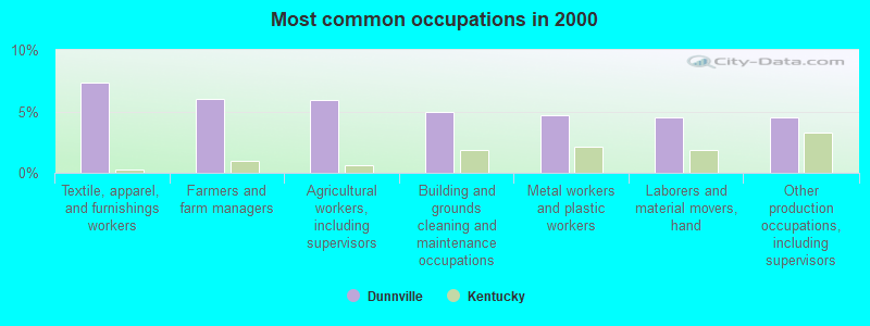
- Textile, apparel, and furnishings workers (7.4%)
- Farmers and farm managers (6.0%)
- Agricultural workers, including supervisors (5.9%)
- Building and grounds cleaning and maintenance occupations (5.0%)
- Metal workers and plastic workers (4.6%)
- Laborers and material movers, hand (4.5%)
- Other production occupations, including supervisors (4.5%)
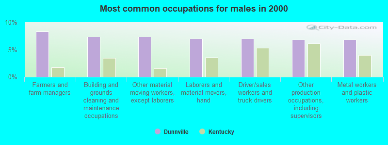
- Farmers and farm managers (8.3%)
- Building and grounds cleaning and maintenance occupations (7.4%)
- Other material moving workers, except laborers (7.4%)
- Laborers and material movers, hand (7.0%)
- Driver/sales workers and truck drivers (7.0%)
- Other production occupations, including supervisors (6.8%)
- Metal workers and plastic workers (6.8%)
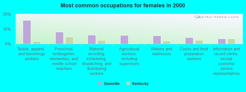
- Textile, apparel, and furnishings workers (15.9%)
- Preschool, kindergarten, elementary, and middle school teachers (7.9%)
- Material recording, scheduling, dispatching, and distributing workers (6.0%)
- Agricultural workers, including supervisors (5.8%)
- Waiters and waitresses (5.5%)
- Cooks and food preparation workers (4.4%)
- Information and record clerks, except customer service representatives (3.6%)
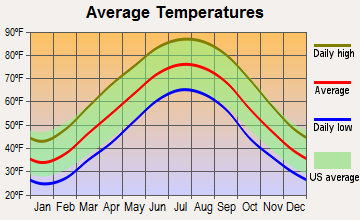
Average climate in Dunnville, Kentucky
Based on data reported by over 4,000 weather stations


(lower is better)
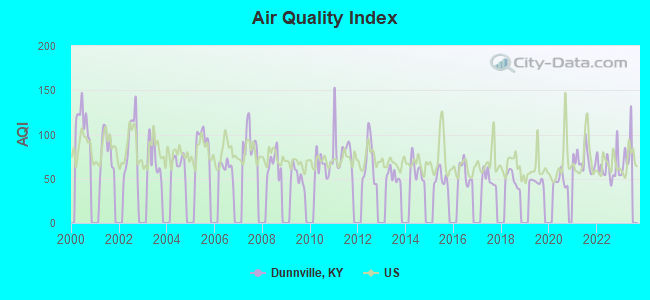
Air Quality Index (AQI) level in 2022 was 62.9. This is about average.
| City: | 62.9 |
| U.S.: | 72.6 |
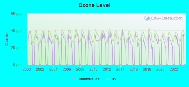
Ozone [ppb] level in 2022 was 28.6. This is about average. Closest monitor was 19.0 miles away from the city center.
| City: | 28.6 |
| U.S.: | 33.3 |
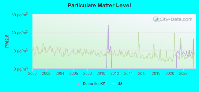
Particulate Matter (PM2.5) [µg/m3] level in 2022 was 7.87. This is about average. Closest monitor was 19.0 miles away from the city center.
| City: | 7.87 |
| U.S.: | 8.11 |
Tornado activity:
Dunnville-area historical tornado activity is near Kentucky state average. It is 30% greater than the overall U.S. average.
On 4/27/1971, a category F4 (max. wind speeds 207-260 mph) tornado 9.8 miles away from the Dunnville place center killed 2 people and injured 72 people and caused between $500,000 and $5,000,000 in damages.
On 4/27/1971, a category F4 tornado 14.8 miles away from the place center killed 6 people and injured 58 people.
Earthquake activity:
Dunnville-area historical earthquake activity is significantly above Kentucky state average. It is 102% greater than the overall U.S. average.On 7/27/1980 at 18:52:21, a magnitude 5.2 (5.1 MB, 4.7 MS, 5.0 UK, 5.2 UK, Class: Moderate, Intensity: VI - VII) earthquake occurred 89.4 miles away from Dunnville center
On 4/18/2008 at 09:36:59, a magnitude 5.4 (5.1 MB, 4.8 MS, 5.4 MW, 5.2 MW) earthquake occurred 183.4 miles away from the city center
On 4/18/2008 at 09:36:59, a magnitude 5.2 (5.2 MW, Depth: 8.9 mi) earthquake occurred 183.4 miles away from the city center
On 6/18/2002 at 17:37:15, a magnitude 5.0 (4.3 MB, 4.6 MW, 5.0 LG) earthquake occurred 165.3 miles away from Dunnville center
On 9/7/1988 at 02:28:09, a magnitude 4.6 (4.5 MB, 4.6 LG, Class: Light, Intensity: IV - V) earthquake occurred 88.3 miles away from the city center
On 11/30/1973 at 07:48:41, a magnitude 4.7 (4.7 MB, 4.6 ML) earthquake occurred 110.0 miles away from the city center
Magnitude types: regional Lg-wave magnitude (LG), body-wave magnitude (MB), local magnitude (ML), surface-wave magnitude (MS), moment magnitude (MW)
Natural disasters:
The number of natural disasters in Casey County (23) is greater than the US average (15).Major Disasters (Presidential) Declared: 18
Emergencies Declared: 3
Causes of natural disasters: Floods: 14, Storms: 13, Tornadoes: 7, Winter Storms: 6, Mudslides: 4, Winds: 3, Landslides: 2, Blizzard: 1, Freeze: 1, Hurricane: 1, Snow: 1, Snowfall: 1, Snowstorm: 1, Other: 1 (Note: some incidents may be assigned to more than one category).
Colleges/universities with over 2000 students nearest to Dunnville:
- Somerset Community College (about 20 miles; Somerset, KY; Full-time enrollment: 4,698)
- Lindsey Wilson College (about 21 miles; Columbia, KY; FT enrollment: 2,552)
- Campbellsville University (about 26 miles; Campbellsville, KY; FT enrollment: 2,948)
- Eastern Kentucky University (about 53 miles; Richmond, KY; FT enrollment: 13,525)
- University of the Cumberlands (about 53 miles; Williamsburg, KY; FT enrollment: 3,585)
- Elizabethtown Community and Technical College (about 63 miles; Elizabethtown, KY; FT enrollment: 3,762)
- Bluegrass Community and Technical College (about 64 miles; Lexington, KY; FT enrollment: 8,560)
Points of interest:
Notable locations in Dunnville: Pumpkin Chapel (A), The Flatwoods Section (B), Dunnville Volunteer Fire Department (C), South Fork Volunteer Fire Department (D). Display/hide their locations on the map
Churches in Dunnville include: Jenny Chapel (A), Locust Grove Church (B), Oak Grove Church (C), Baldock Chapel (D), Bethany Church of Christ (E), Thomas Ridge Christian Church (F), Canaan Valley Separate Baptist Church (G), Cedar Springs Church (H), South Fork Church (I). Display/hide their locations on the map
Cemeteries: Thomastown Cemetery (1), Bowmer Cemetery (2), Luttrell Cemetery (3), Carson Cemetery (4), Williams Cemetery (5), Thomas Cemetery (6), Roberts Cemetery (7). Display/hide their locations on the map
Streams, rivers, and creeks: Trace Fork (A), Dry Fork (B), Brock Creek (C), Turkey Creek (D), Tarter Branch (E), Sloan Fork (F), Little Creek (G), Kellum Branch (H), Jones Branch (I). Display/hide their locations on the map
| This place: | 2.7 people |
| Kentucky: | 2.5 people |
| This place: | 69.3% |
| Whole state: | 66.9% |
| This place: | 3.9% |
| Whole state: | 6.4% |
Likely homosexual households (counted as self-reported same-sex unmarried-partner households)
- Lesbian couples: 0.3% of all households
- Gay men: 0.3% of all households
| This place: | 33.1% |
| Whole state: | 15.8% |
| This place: | 18.0% |
| Whole state: | 6.6% |
17 people in workers' group living quarters and job corps centers in 2010
69 people in homes for abused, dependent, and neglected children in 2000
2 people in other nonhousehold living situations in 2000
Banks with branches in Dunnville (2011 data):
- The Casey County Bank, Inc.: Dunnville Branch at U.S. Highway 127, branch established on 1972/06/02. Info updated 2009/11/03: Bank assets: $160.2 mil, Deposits: $132.5 mil, headquarters in Liberty, KY, positive income, 4 total offices, Holding Company: Casey County Bancorp, Inc.
For population 15 years and over in Dunnville:
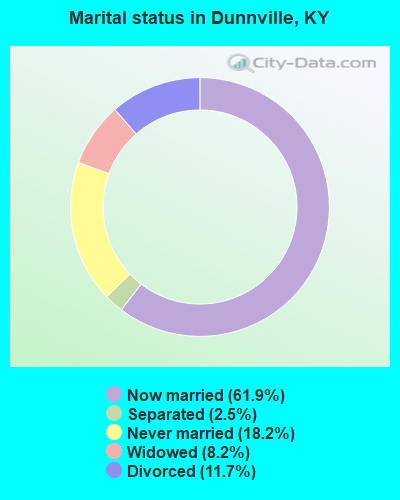
- Never married: 18.2%
- Now married: 61.9%
- Separated: 2.5%
- Widowed: 8.2%
- Divorced: 11.7%
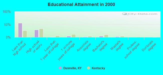
For population 25 years and over in Dunnville:
- High school or higher: 44.6%
- Bachelor's degree or higher: 7.6%
- Graduate or professional degree: 3.0%
- Unemployed: 2.1%
- Mean travel time to work (commute): 25.9 minutes
| Here: | 19.4 |
| Kentucky average: | 13.8 |
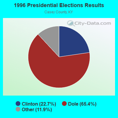
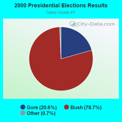
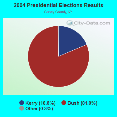
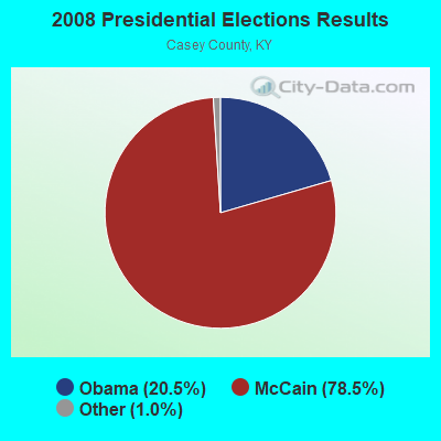
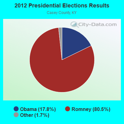
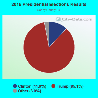

Graphs represent county-level data. Detailed 2008 Election Results
Religion statistics for Dunnville, KY (based on Casey County data)
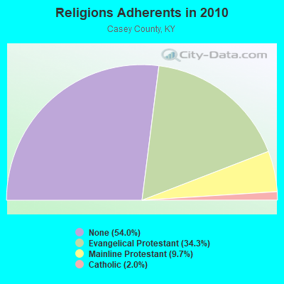
| Religion | Adherents | Congregations |
|---|---|---|
| Evangelical Protestant | 5,470 | 46 |
| Mainline Protestant | 1,554 | 13 |
| Catholic | 312 | 2 |
| Other | 2 | - |
| None | 8,617 | - |
Food Environment Statistics:
| Here: | 4.34 / 10,000 pop. |
| Kentucky: | 2.19 / 10,000 pop. |
| Casey County: | 2.48 / 10,000 pop. |
| Kentucky: | 0.74 / 10,000 pop. |
| Here: | 6.82 / 10,000 pop. |
| Kentucky: | 4.36 / 10,000 pop. |
| Casey County: | 3.72 / 10,000 pop. |
| State: | 5.74 / 10,000 pop. |
| Casey County: | 12.7% |
| Kentucky: | 11.0% |
| Here: | 31.2% |
| Kentucky: | 30.0% |
| This county: | 15.1% |
| Kentucky: | 15.9% |
Strongest AM radio stations in Dunnville:
- WHAS (840 AM; 50 kW; LOUISVILLE, KY; Owner: CLEAR CHANNEL BROADCASTING LICENSES, INC.)
- WKDO (1560 AM; daytime; 1 kW; LIBERTY, KY; Owner: CARLOS WESLEY)
- WIDS (570 AM; 0 kW; RUSSELL SPRINGS, KY; Owner: HAMMOND BROADCASTING, INC.)
- WKVL (850 AM; daytime; 50 kW; KNOXVILLE, TN; Owner: HORNE RADIO, LLC)
- WJKY (1060 AM; daytime; 1 kW; JAMESTOWN, KY; Owner: LAKE CUMBERLAND BROADCASTERS)
- WSM (650 AM; 50 kW; NASHVILLE, TN; Owner: GAYLORD ENTERTAINMENT COMPANY)
- WAMB (1160 AM; 50 kW; DONELSON, TN; Owner: GREAT SOUTHERN BROADCASTING COMPANY, INC.)
- WLW (700 AM; 50 kW; CINCINNATI, OH; Owner: JACOR BROADCASTING CORPORATION)
- WKDA (1200 AM; 50 kW; NASHVILLE, TN; Owner: RADIO NASHVILLE, INC.)
- WWAM (820 AM; daytime; 50 kW; JASPER, TN; Owner: SHELTON BROADCASTING SYSTEM)
- WLAC (1510 AM; 50 kW; NASHVILLE, TN; Owner: CAPSTAR TX LIMITED PARTNERSHIP)
- WNQM (1300 AM; 50 kW; NASHVILLE, TN; Owner: WNQM. INC.)
- WEKC (710 AM; daytime; 4 kW; WILLIAMSBURG, KY; Owner: GERALD PARKS)
Strongest FM radio stations in Dunnville:
- WDCL-FM (89.7 FM; SOMERSET, KY; Owner: WESTERN KENTUCKY UNIVERSITY)
- WSEK (97.1 FM; SOMERSET, KY; Owner: CAPSTAR TX LIMITED PARTNERSHIP)
- WKDO-FM (98.7 FM; LIBERTY, KY; Owner: CARLOS D. WESLEY)
- WJRS (104.9 FM; JAMESTOWN, KY; Owner: LAKE CUMBERLAND BROADCASTERS)
- WXKY-FM (96.3 FM; STANFORD, KY; Owner: LINCOLN-GARRARD BROADCASTING CO.,INC)
- WTHL (90.5 FM; SOMERSET, KY; Owner: SOMERSET EDUCATIONAL BROADCASTING FOUNDATION)
- WHVE (92.7 FM; RUSSELL SPRINGS, KY; Owner: SHORELINE COMMUNICATIONS, INC)
- WMKZ (93.1 FM; MONTICELLO, KY; Owner: MONTICELLO-WAYNE COUNTY MEDIA, INC.)
- WKII-FM (102.3 FM; SOMERSET, KY; Owner: CAPSTAR TX LIMITED PARTNERSHIP)
- WKYM (101.7 FM; MONTICELLO, KY; Owner: STEPHEN W. STAPLES JR.)
- WVLC (99.9 FM; MANNSVILLE, KY; Owner: PATRICIA RODGERS)
- WLLK (93.9 FM; BURNSIDE, KY; Owner: CAPSTAR TX LIMITED PARTNERSHIP)
- W277AA (103.3 FM; SOMERSET, KY; Owner: WESTERN KENTUCKY UNIVERSITY)
- WCKQ (104.1 FM; CAMPBELLSVILLE, KY; Owner: CBC OF MARION & TAYLOR COUNTIES INC)
TV broadcast stations around Dunnville:
- WKSO-TV (Channel 29; SOMERSET, KY; Owner: KENTUCKY AUTHORITY FOR EDUCATIONAL TV)
- WBKI-TV (Channel 34; CAMPBELLSVILLE, KY; Owner: LOUISVILLE COMMUNICATIONS, LLC)
- WDKY-TV (Channel 56; DANVILLE, KY; Owner: WDKY LICENSEE, LLC)
FCC Registered Antenna Towers:
4- JOHN HEMPHILL, 1084 Spring Hill Road (Lat: 37.194250 Lon: -84.980222), Type: 97.5, Overall height: 91.4 m, Registrant: Hemphill Corporation, Tulsa, Phone: (918) 834-2200
- Ronald R Smith, 350 Pittman Road (Lat: 37.175278 Lon: -85.003194), Type: 77.7, Overall height: 73.2 m, Registrant: Lukas, Nace, Gutierrez & Sachs, LLP, Pgist@fcclaw.Com, , Mclea-n, Phone: (703) 584-8665
- Ronald R Smith, 350 Pittman Road (Lat: 37.175278 Lon: -85.003194), Type: 77.7, Overall height: 73.2 m, Registrant: Lukas, Nace, Gutierrez & Sachs, LLP, Pgist@fcclaw.Com, , Mclea-n, Phone: (703) 584-8665
- Christophe Le Scanve, 350 Pittman Road (Lat: 37.175278 Lon: -85.003194), Type: 77.7, Structure height: 21045 m, Overall height: 73.2 m, Registrant: Bluegrass Wireless LLC, 5012 Eliza-bethtown, Phone: (270) 769-0339
FCC Registered Microwave Towers:
1- POPLAR GROVE, Old Poplar Grove Rd. (Lat: 37.142000 Lon: -85.054389), Overall height: 62.5 m, Call Sign: WGW688,
Assigned Frequencies: 11365.0 MHz, 11285.0 MHz, 11605.0 MHz, 11525.0 MHz, Grant Date: 01/03/2001, Expiration Date: 02/01/2011, Cancellation Date: 07/13/2001, Registrant: Verizon Services Group, 1850 M Street, Nw Suite 1200, Washington, DC 20036-5801, Phone: (202) 463-5295, Email:
FCC Registered Amateur Radio Licenses:
2- Call Sign: WA4POH, Previous Call Sign: AD4UZ, Grant Date: 08/30/1996, Expiration Date: 08/30/2006, Cancellation Date: 09/03/2008, Registrant: Barry W Arnett, R1 Box 221, Dunnville, KY 42528
- Call Sign: KG4JOA, Licensee ID: L00285242, Grant Date: 09/19/2000, Expiration Date: 09/19/2010, Cancellation Date: 09/20/2012, Certifier: Timothy P Frey, Registrant: Timothy P Frey, 1848 Decatur Rd., Dunnville, KY 42528
2005 - 2018 National Fire Incident Reporting System (NFIRS) incidents
- Fire incident types reported to NFIRS in Dunnville, KY
- 5843.3%Outside Fires
- 4735.1%Structure Fires
- 1511.2%Other
- 1410.4%Mobile Property/Vehicle Fires
 According to the data from the years 2005 - 2018 the average number of fire incidents per year is 10. The highest number of reported fires - 17 took place in 2018, and the least - 3 in 2014. The data has a growing trend.
 When looking into fire subcategories, the most incidents belonged to: Outside Fires (43.3%), and Structure Fires (35.1%).
- 46.2%Electricity
- 23.0%Wood
- 19.5%Bottled, tank, or LP gas
- 8.1%Fuel oil, kerosene, etc.
- 1.9%No fuel used
- 1.3%Utility gas
- 42.5%Wood
- 34.3%Electricity
- 17.1%Fuel oil, kerosene, etc.
- 6.1%Bottled, tank, or LP gas
Dunnville compared to Kentucky state average:
- Median household income below state average.
- Median house value below state average.
- Unemployed percentage significantly below state average.
- Black race population percentage significantly below state average.
- Hispanic race population percentage significantly below state average.
- Median age below state average.
- Foreign-born population percentage significantly below state average.
- Renting percentage below state average.
- Length of stay since moving in significantly above state average.
- Number of rooms per house significantly below state average.
- House age significantly below state average.
- Number of college students below state average.
- Percentage of population with a bachelor's degree or higher significantly below state average.
Dunnville on our top lists:
- #11 on the list of "Top 101 cities with the largest percentage of people in homes for abused, dependent, and neglected children (population 1,000+)"
- #36 (42539) on the list of "Top 101 zip codes with the largest percentage of United States first ancestries (pop 5,000+)"