Submit your own pictures of this place and show them to the world
OSM Map
Google Map
MSN Map
OSM Map
General Map
Google Map
MSN Map
OSM Map
Google Map
MSN Map
OSM Map
Google Map
MSN Map
Please wait while loading the map...
Population in 2010: 199.
Males: 93
(47.0%)
Females: 106
(53.0%)
Median resident age:
64.7 years
Missouri median age:
39.1 years
Estimated median household income in 2022: $54,657
Eagle Rock:
$54,657
MO:
$64,811
Estimated per capita income in 2022: $30,836
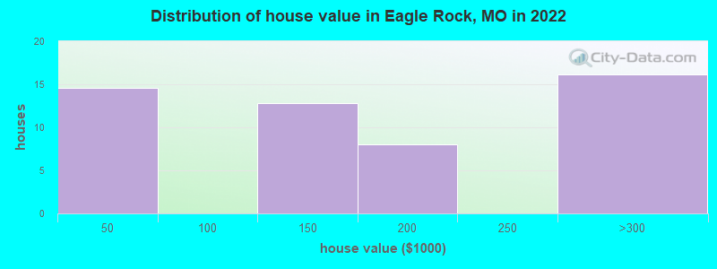
Estimated median house or condo value in 2022: $176,383
Eagle Rock:
$176,383
MO:
$221,200
Mean prices in 2022:all housing units: $344,854; detached houses: $342,322March 2022 cost of living index in Eagle Rock: 75.7 (low, U.S. average is 100)Percentage of residents living in poverty in 2022: 0.0%
Eagle Rock-area historical tornado activity is near Missouri state average. It is 64% greater than the overall U.S. average.
On 3/24/1954, a category F3 (max. wind speeds 158-206 mph) tornado 11.9 miles away from the Eagle Rock place center injured 4 peopleand causedbetween $500 and $5000 in damages.
On 3/24/1954, a category F3 tornado 12.8 miles away from the place center injured 2 peopleand causedbetween $5000 and $50,000 in damages.
Earthquake activity:
Eagle Rock-area historical earthquake activity is significantly above Missouri state average. It is 608% greater than the overall U.S. average.
On 9/3/2016 at 12:02:44, a magnitude 5.8 (5.8 MW, Depth: 3.5 mi, Class: Moderate, Intensity: VI - VII) earthquake occurred 176.8 miles away from Eagle Rock center On 11/6/2011 at 03:53:10, a magnitude 5.7 (5.7 MW, Depth: 3.2 mi) earthquake occurred 182.5 miles away from the city center On 11/7/2016 at 01:44:24, a magnitude 5.0 (5.0 MW, Depth: 2.8 mi) earthquake occurred 174.3 miles away from Eagle Rock center On 2/28/2011 at 05:00:50, a magnitude 4.7 (4.7 MW, Depth: 2.0 mi, Class: Light, Intensity: IV - V) earthquake occurred 118.2 miles away from the city center On 5/4/2001 at 06:42:12, a magnitude 4.7 (4.2 MB, 4.7 LG, 4.5 LG) earthquake occurred 127.6 miles away from the city center On 1/21/1982 at 00:33:54, a magnitude 4.7 (4.5 MB, 4.7 LG, 4.5 LG) earthquake occurred 128.8 miles away from Eagle Rock center Magnitude types: regional Lg-wave magnitude (LG), body-wave magnitude (MB), moment magnitude (MW)
Natural disasters:
The number of natural disasters in Barry County (25) is a lot greater than the US average (15). Major Disasters (Presidential) Declared: 17 Emergencies Declared: 5
Causes of natural disasters: Storms: 18, Floods: 17, Tornadoes: 14, Winds: 5, Winter Storms: 5, Hurricane: 1, Other: 1 (Note: some incidents may be assigned to more than one category).
Hospitals and medical centers near Eagle Rock:
EUREKA SPRINGS HOSPITAL, LLC Critical Access Hospitals (about 11 miles away; EUREKA SPRINGS, AR)
ST JOHNS HOSPITAL-CASSVILLE (Hospital, about 11 miles away; CASSVILLE, MO)
QUALITY HOME HEALTH AND HOSPICE (Hospital, about 11 miles away; CASSVILLE, MO)
RED ROSE HEALTH AND REHABILITATION CENTER (Nursing Home, about 12 miles away; CASSVILLE, MO)
BRIGHTON RIDGE (Nursing Home, about 12 miles away; EUREKA SPRINGS, AR)
MCL, Acute (TCR) - In JAN-2014, Contaminant: Coliform. Follow-up actions: St Boil Water Order (JAN-18-2014), St Public Notif requested (JAN-24-2014), St Formal NOV issued (JAN-24-2014), St Other (JAN-31-2014), St Public Notif received (MAR-20-2014), St Compliance achieved (APR-15-2014)
MCL, Monthly (TCR) - In JAN-2014, Contaminant: Coliform. Follow-up actions: St Public Notif requested (JAN-24-2014), St Formal NOV issued (JAN-24-2014), St Public Notif received (MAR-20-2014), St Compliance achieved (APR-15-2014)
MCL, Monthly (TCR) - In OCT-2012, Contaminant: Coliform. Follow-up actions: St Public Notif requested (NOV-09-2012), St Formal NOV issued (NOV-09-2012), St Public Notif received (DEC-03-2012), St Compliance achieved (JAN-22-2014)
MCL, Monthly (TCR) - In JUN-2008, Contaminant: Coliform. Follow-up actions: St Public Notif requested (JUN-17-2008), St Violation/Reminder Notice (JUN-17-2008), St Public Notif issued (SEP-09-2008), St Consent Decree/Judgement (DEC-29-2008), St Compliance achieved (APR-07-2011)
Past monitoring violations:
5 routine major monitoring violations
One minor monitoring violation
CHAIN O LAKES VILLAGE (Population served: 160, Groundwater):
MCL, Monthly (TCR) - In APR-2013, Contaminant: Coliform. Follow-up actions: St Public Notif requested (APR-12-2013), St Formal NOV issued (APR-12-2013), St BCA signed (JUN-10-2013), St Compliance achieved (AUG-19-2013)
MCL, Monthly (TCR) - In FEB-2013, Contaminant: Coliform. Follow-up actions: St Formal NOV issued (MAR-08-2013), St Public Notif requested (MAR-08-2013), St Violation/Reminder Notice (MAR-22-2013), St BCA signed (JUN-10-2013), St Compliance achieved (AUG-19-2013)
MCL, Monthly (TCR) - In JAN-2013, Contaminant: Coliform. Follow-up actions: St Formal NOV issued (FEB-08-2013), St Public Notif requested (FEB-08-2013), St Violation/Reminder Notice (MAR-22-2013), St BCA signed (JUN-10-2013), St Compliance achieved (AUG-19-2013)
Past monitoring violations:
Monitoring, Source Water (GWR) - In AUG-01-2013, Contaminant: E. COLI. Follow-up actions: St Public Notif requested (AUG-23-2013), St Violation/Reminder Notice (AUG-23-2013), St Public Notif received (OCT-04-2013)
MCL, Acute (TCR) - In OCT-2008, Contaminant: Coliform. Follow-up actions: St Public Notif requested (OCT-27-2008), St Boil Water Order (OCT-27-2008), St Formal NOV issued (OCT-27-2008), St Public Notif issued (OCT-27-2008), St Public Notif requested (OCT-29-2008), St Formal NOV issued (OCT-29-2008), St Public Notif received (NOV-03-2008), St Other (NOV-07-2008), St Compliance achieved (JAN-22-2014)
MCL, Monthly (TCR) - In OCT-2008, Contaminant: Coliform. Follow-up actions: St Public Notif requested (OCT-24-2008), St Violation/Reminder Notice (OCT-24-2008), St Public Notif requested (OCT-27-2008), St Formal NOV issued (OCT-27-2008), St Public Notif received (NOV-03-2008), St Compliance achieved (JAN-22-2014)
Past monitoring violations:
One minor monitoring violation
MITCHELLS PLAZA (Population served: 25, Groundwater):
Past health violations:
MCL, Monthly (TCR) - In NOV-2006, Contaminant: Coliform. Follow-up actions: St Public Notif requested (DEC-18-2006), St Violation/Reminder Notice (DEC-18-2006), St Public Notif issued (JUN-29-2012), St Compliance achieved (JAN-22-2014)
MCL, Monthly (TCR) - In AUG-2005, Contaminant: Coliform. Follow-up actions: St Public Notif requested (SEP-07-2005), St Violation/Reminder Notice (SEP-07-2005), St Public Notif issued (FEB-22-2006), St BCA signed (APR-13-2006), St Compliance achieved (JUN-09-2011), St Public Notif issued (JUN-29-2012)
Past monitoring violations:
Monitoring, Source Water (GWR) - In NOV-01-2013, Contaminant: E. COLI. Follow-up actions: St Public Notif requested (DEC-04-2013), St Violation/Reminder Notice (2 times from DEC-04-2013 to DEC-13-2013)
Monitoring, Repeat Major (TCR) - In OCT-2013, Contaminant: Coliform (TCR). Follow-up actions: St Public Notif requested (DEC-03-2013), St Violation/Reminder Notice (2 times from DEC-03-2013 to DEC-13-2013), St Compliance achieved (JAN-22-2014)
14 routine major monitoring violations
5 minor monitoring violations
UNCLE ROYS ONE STOP (Population served: 25, Groundwater):
Past health violations:
MCL, Monthly (TCR) - In APR-2012, Contaminant: Coliform. Follow-up actions: St Public Notif requested (MAY-04-2012), St Violation/Reminder Notice (3 times from MAY-04-2012 to JUN-04-2012), St Public Notif received (AUG-10-2012), St Compliance achieved (SEP-30-2012)
MCL, Monthly (TCR) - In FEB-2005, Contaminant: Coliform. Follow-up actions: St Public Notif requested (MAR-03-2005), St Violation/Reminder Notice (MAR-03-2005), St Formal NOV issued (APR-22-2005), St Public Notif received (MAY-10-2005), St Formal NOV issued (JUN-22-2005), St BCA signed (JUL-19-2005), St Compliance achieved (JUL-10-2006)
Past monitoring violations:
Monitoring, Source Water (GWR) - In JUL-01-2012, Contaminant: E. COLI. Follow-up actions: St Public Notif requested (JUL-18-2012), St Violation/Reminder Notice (JUL-18-2012), St Compliance achieved (SEP-30-2012)
8 routine major monitoring violations
One minor monitoring violation
SHORELINE CAMPGROUND AND RESORT (Population served: 25, Groundwater):
Past health violations:
MCL, Monthly (TCR) - In AUG-2010, Contaminant: Coliform. Follow-up actions: St Public Notif requested (AUG-18-2010), St Violation/Reminder Notice (AUG-18-2010), St Other (MAR-28-2011), St Public Notif received (JUN-20-2011), St AO (w/penalty) issued (JUL-11-2011), St Compliance achieved (2 times from AUG-18-2011 to JUL-11-2012)
MCL, Monthly (TCR) - In JUL-2010, Contaminant: Coliform. Follow-up actions: St Public Notif requested (JUL-30-2010), St Violation/Reminder Notice (JUL-30-2010), St Other (MAR-28-2011), St Public Notif received (JUN-20-2011), St AO (w/penalty) issued (JUL-11-2011), St Compliance achieved (2 times from AUG-18-2011 to JUL-11-2012)
MCL, Monthly (TCR) - In JUN-2010, Contaminant: Coliform. Follow-up actions: St Public Notif requested (JUL-01-2010), St Violation/Reminder Notice (JUL-01-2010), St Other (MAR-28-2011), St Public Notif received (JUN-20-2011), St AO (w/penalty) issued (JUL-11-2011), St Compliance achieved (2 times from AUG-18-2011 to JUL-11-2012)
MCL, Monthly (TCR) - In JUN-2009, Contaminant: Coliform. Follow-up actions: St Public Notif requested (JUL-07-2009), St Violation/Reminder Notice (JUL-07-2009), St Public Notif received (JUN-20-2011), St AO (w/penalty) issued (JUL-11-2011), St Compliance achieved (JUL-11-2012)
MCL, Monthly (TCR) - In MAY-2009, Contaminant: Coliform. Follow-up actions: St Public Notif requested (JUN-09-2009), St Violation/Reminder Notice (JUN-09-2009), St Public Notif received (JUN-20-2011), St AO (w/penalty) issued (JUL-11-2011), St Compliance achieved (JUL-11-2012)
MCL, Monthly (TCR) - In JUN-2008, Contaminant: Coliform. Follow-up actions: St Violation/Reminder Notice (JUL-15-2008), St Public Notif requested (JUL-15-2008), St Public Notif received (JUN-20-2011), St Compliance achieved (JAN-22-2014)
MCL, Monthly (TCR) - In JUL-2005, Contaminant: Coliform. Follow-up actions: St Public Notif requested (AUG-04-2005), St Violation/Reminder Notice (AUG-04-2005), St Public Notif received (2 times from AUG-22-2005 to JUN-20-2011), St Compliance achieved (JAN-22-2014)
Past monitoring violations:
Monitoring, Source Water (GWR) - In JUL-01-2010, Contaminant: E. COLI. Follow-up actions: St Public Notif requested (AUG-30-2010), St Violation/Reminder Notice (AUG-30-2010), St Other (MAR-28-2011), St Public Notif received (JUN-20-2011), St AO (w/penalty) issued (JUL-11-2011), St Compliance achieved (JUL-11-2012)
One routine major monitoring violation
Average household size:
This place:
2.0 people
Missouri:
2.5 people
Percentage of family households:
This place:
60.2%
Whole state:
65.3%
Percentage of households with unmarried partners:
This place:
9.2%
Whole state:
6.7%
Likely homosexual households (counted as self-reported same-sex unmarried-partner households)
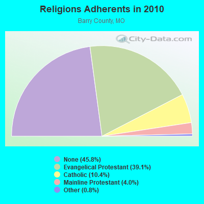
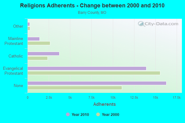
Religion statistics for Eagle Rock, MO (based on Barry County data)
Religion
Adherents
Congregations
Evangelical Protestant
13,905
84
Catholic
3,719
4
Mainline Protestant
1,414
13
Other
270
4
None
16,289
-
Source: Clifford Grammich, Kirk Hadaway, Richard Houseal, Dale E.Jones, Alexei Krindatch, Richie Stanley and Richard H.Taylor. 2012. 2010 U.S.Religion Census: Religious Congregations & Membership Study. Association of Statisticians of American Religious Bodies. Jones, Dale E., et al. 2002. Congregations and Membership in the United States 2000. Nashville, TN: Glenmary Research Center. Graphs represent county-level data
SUGAR CAMP TOWER, Sugar Camp Looktout Tower, County Road (Lat: 36.528417 Lon: -93.833806), Type: Tower, Structure height: 43 m, Overall height: 46 m, Call Sign: WNUS240, Assigned Frequencies: 151.190 MHz, 151.355 MHz, 151.325 MHz, Grant Date: 03/14/2023, Expiration Date: 06/04/2033, Certifier: E John Alberts, Registrant: Conservation Commission Of The State Of Missouri, 230 Commerce Drive, Suite 201, Jefferson City, MO 65102-0180, Phone: (573) 522-4115, Fax: (573) 751-4865, Email:
FCC Registered Microwave Towers:
1
ROARING RIVER, 2429 Parkview Drive (Lat: 36.579333 Lon: -93.837750), Type: Mtower, Structure height: 59.4 m, Overall height: 60.6 m, Call Sign: WQRI757, Assigned Frequencies: 6330.66 MHz, 6330.66 MHz, 6330.66 MHz, 6330.66 MHz, 6330.66 MHz, 6389.96 MHz, 6389.96 MHz, 6389.96 MHz, 6389.96 MHz, 6389.96 MHz, 6226.89 MHz, Grant Date: 04/18/2023, Expiration Date: 05/22/2033, Certifier: Gregory M Romano, Registrant: Cellco Partnership, 5055 North Point Pkwy, Np2ne Network Engineering, Alpharetta, GA 30022, Phone: (770) 797-1070, Email:
Aircraft: EAGLE AIRCRAFT 150B (Category: Land, Seats: 2, Weight: Up to 12,499 Pounds), Engine: CONT MOTOR IO-240-B (125 HP) (4 Cycle) N-Number: 156EA, N156EA, N-156EA, Serial Number: 031, Year manufactured: 2000, Airworthiness Date: 07/28/2011, Certificate Issue Date: 02/27/2020 Registrant (Co-Owned): David R Mcdonald, 22452 Bend Ln, Eagle Rock, MO 65641, Other Owners: Theresa G Mcdonald
Aircraft: CHAMPION 7FC (Category: Land, Seats: 2, Weight: Up to 12,499 Pounds, Speed: 90 mph), Engine: CONT MOTOR C90 SERIES (95 HP) (Reciprocating) N-Number: 644MP, N644MP, N-644MP, Serial Number: 7FC-192, Airworthiness Date: 05/12/1958, Certificate Issue Date: 08/02/2018 Registrant (Individual): Darrin M Jacobs, 27751 Farm Road 1198, Eagle Rock, MO 65641
Aircraft: CESSNA 172F (Category: Land, Seats: 4, Weight: Up to 12,499 Pounds, Speed: 105 mph), Engine: CONT MOTOR 0-300 SER (145 HP) (Reciprocating) N-Number: 8640U, N8640U, N-8640U, Serial Number: 17252542, Year manufactured: 1965, Airworthiness Date: 03/18/1965, Certificate Issue Date: 10/13/2017 Registrant (Individual): Joshua Joe Stillwell, 28384 Farm Road 1220, Eagle Rock, MO 65641
Aircraft: CESSNA 177A (Category: Land, Seats: 4, Weight: Up to 12,499 Pounds, Speed: 108 mph), Engine: LYCOMING O&VO-360 SER (180 HP) (Reciprocating) N-Number: 30398, N30398, N-30398, Serial Number: 17701235, Year manufactured: 1968, Airworthiness Date: 09/24/1968 Registrant (Individual): Reported Sale, 22082 Eagles Nest Ln, Eagle Rock, MO 65641 Deregistered:Cancel Date: 05/30/2018
2002 - 2018 National Fire Incident Reporting System (NFIRS) incidents
Based on the data from the years 2002 - 2018 the average number of fire incidents per year is 15. The highest number of reported fires - 25 took place in 2012, and the least - 4 in 2018. The data has a decreasing trend.
When looking into fire subcategories, the most reports belonged to: Outside Fires (56.1%), and Structure Fires (27.5%).
Fire incident types reported to NFIRS in Eagle Rock, MO


 Recent articles from our blog. Our writers, many of them Ph.D. graduates or candidates, create easy-to-read articles on a wide variety of topics.
 (39.7 miles
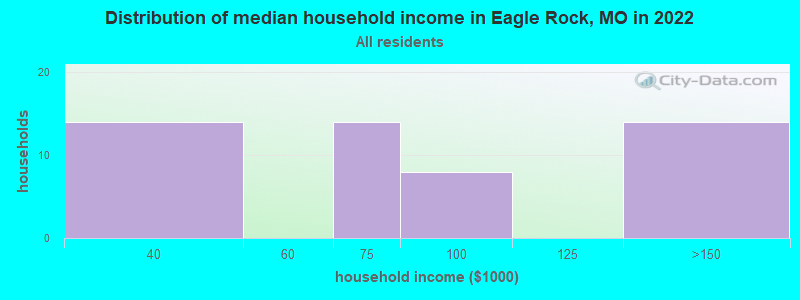


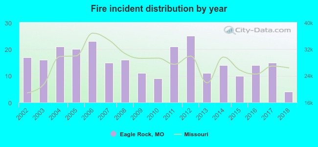 Based on the data from the years 2002 - 2018 the average number of fire incidents per year is 15. The highest number of reported fires - 25 took place in 2012, and the least - 4 in 2018. The data has a decreasing trend.
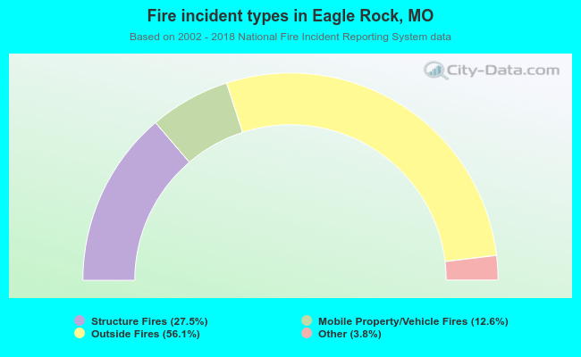 When looking into fire subcategories, the most reports belonged to: Outside Fires (56.1%), and Structure Fires (27.5%).