East Adams, Colorado
Submit your own pictures of this place and show them to the world
- OSM Map
- General Map
- Google Map
- MSN Map
| Males: 3,434 | |
| Females: 3,321 |
| Median resident age: | 35.1 years |
| Colorado median age: | 34.3 years |
Zip code: 80136
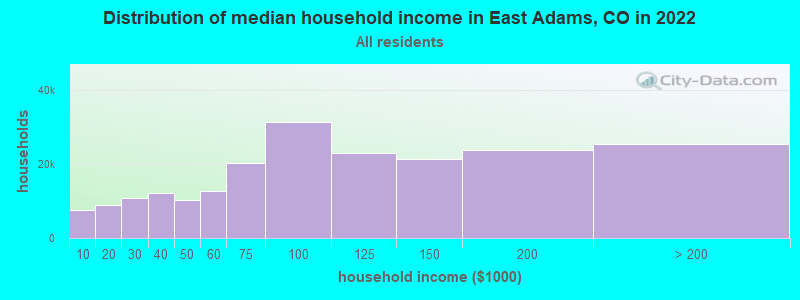
| East Adams: | $99,472 |
| CO: | $89,302 |
Estimated per capita income in 2022: $44,808 (it was $22,423 in 2000)
East Adams CCD income, earnings, and wages data
Estimated median house or condo value in 2022: $486,610 (it was $142,700 in 2000)
| East Adams: | $486,610 |
| CO: | $531,100 |
Mean prices in 2022: all housing units: $511,179; detached houses: $576,428; townhouses or other attached units: $387,990; in 2-unit structures: $511,676; in 3-to-4-unit structures: $417,982; in 5-or-more-unit structures: $303,466; mobile homes: $84,031; occupied boats, rvs, vans, etc.: $6,549
Detailed information about poverty and poor residents in East Adams, CO


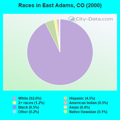
- 5,23092.6%White alone
- 2544.5%Hispanic
- 681.2%Two or more races
- 290.5%Black alone
- 310.5%American Indian alone
- 200.4%Asian alone
- 120.2%Other race alone
- 60.1%Native Hawaiian and Other
Pacific Islander alone
 Recent articles from our blog. Our writers, many of them Ph.D. graduates or candidates, create easy-to-read articles on a wide variety of topics.
Current Local Time: MST time zone
Land area: 870.4 square miles.
Population density: 7.8 people per square mile (very low).

| East Adams CCD: | 0.6% ($881) |
| Colorado: | 0.7% ($1,132) |
Nearest city with pop. 50,000+: Aurora, CO  (30.5 miles , pop. 276,393).
Nearest city with pop. 1,000,000+: Phoenix, AZ (614.3 miles , pop. 1,321,045).
Nearest cities:
), ), )Latitude: 39.83 N, Longitude: 104.26 W
Area code commonly used in this area: 303

| Here: | 3.6% |
| Colorado: | 3.2% |
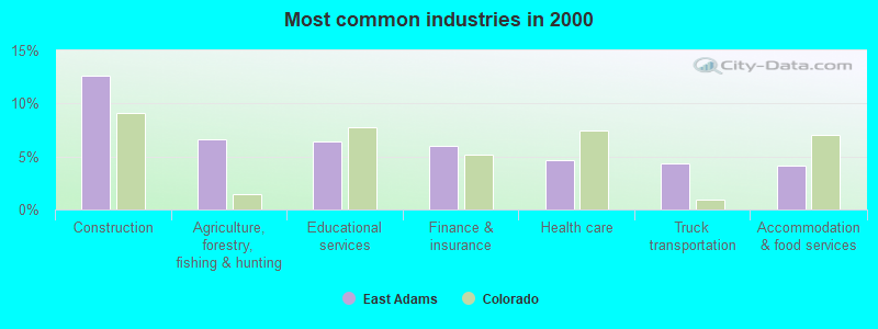
- Construction (12.6%)
- Agriculture, forestry, fishing & hunting (6.6%)
- Educational services (6.4%)
- Finance & insurance (6.0%)
- Health care (4.6%)
- Truck transportation (4.3%)
- Accommodation & food services (4.2%)
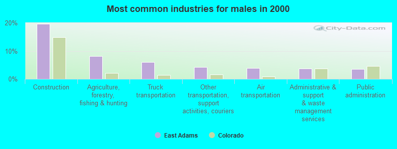
- Construction (19.6%)
- Agriculture, forestry, fishing & hunting (8.2%)
- Truck transportation (6.1%)
- Other transportation, support activities, couriers (4.2%)
- Air transportation (3.9%)
- Administrative & support & waste management services (3.7%)
- Public administration (3.6%)
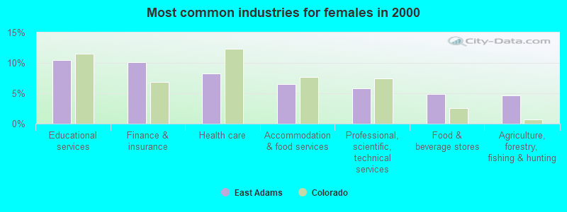
- Educational services (10.4%)
- Finance & insurance (10.1%)
- Health care (8.2%)
- Accommodation & food services (6.6%)
- Professional, scientific, technical services (5.8%)
- Food & beverage stores (4.8%)
- Agriculture, forestry, fishing & hunting (4.7%)
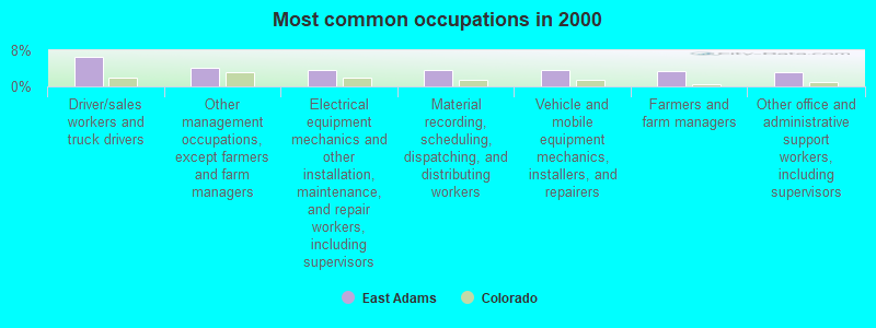
- Driver/sales workers and truck drivers (6.7%)
- Other management occupations, except farmers and farm managers (4.2%)
- Electrical equipment mechanics and other installation, maintenance, and repair workers, including supervisors (3.7%)
- Material recording, scheduling, dispatching, and distributing workers (3.5%)
- Vehicle and mobile equipment mechanics, installers, and repairers (3.5%)
- Farmers and farm managers (3.4%)
- Other office and administrative support workers, including supervisors (3.3%)
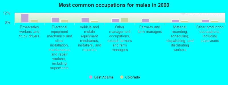
- Driver/sales workers and truck drivers (11.3%)
- Electrical equipment mechanics and other installation, maintenance, and repair workers, including supervisors (6.4%)
- Vehicle and mobile equipment mechanics, installers, and repairers (6.1%)
- Other management occupations, except farmers and farm managers (5.0%)
- Farmers and farm managers (4.7%)
- Material recording, scheduling, dispatching, and distributing workers (3.7%)
- Other production occupations, including supervisors (3.6%)
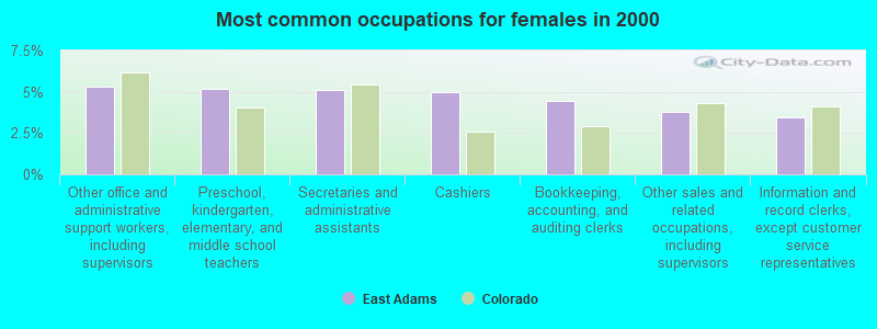
- Other office and administrative support workers, including supervisors (5.3%)
- Preschool, kindergarten, elementary, and middle school teachers (5.2%)
- Secretaries and administrative assistants (5.1%)
- Cashiers (5.0%)
- Bookkeeping, accounting, and auditing clerks (4.4%)
- Other sales and related occupations, including supervisors (3.8%)
- Information and record clerks, except customer service representatives (3.5%)
Average climate in East Adams, Colorado
Based on data reported by over 4,000 weather stations


Tornado activity:
East Adams-area historical tornado activity is significantly above Colorado state average. It is 55% greater than the overall U.S. average.
On 6/12/1982, a category F3 (max. wind speeds 158-206 mph) tornado 14.2 miles away from the East Adams place center caused between $500 and $5000 in damages.
On 5/18/1975, a category F3 tornado 22.1 miles away from the place center .
Earthquake activity:
East Adams-area historical earthquake activity is significantly above Colorado state average. It is 642% greater than the overall U.S. average.On 8/18/1959 at 06:37:13, a magnitude 7.7 (7.7 UK, Class: Major, Intensity: VIII - XII) earthquake occurred 462.8 miles away from the city center, causing $26,000,000 total damage
On 10/18/1984 at 15:30:23, a magnitude 5.5 (5.4 MB, 5.1 MS, 5.5 ML, Class: Moderate, Intensity: VI - VII) earthquake occurred 189.8 miles away from East Adams center
On 8/23/2011 at 05:46:18, a magnitude 5.3 (5.3 MW, Depth: 2.5 mi) earthquake occurred 193.1 miles away from East Adams center
On 10/28/1983 at 14:06:06, a magnitude 7.3 (6.2 MB, 7.3 MS, 7.0 MW) earthquake occurred 571.2 miles away from East Adams center, causing 2 deaths (2 shaking deaths) and 3 injuries, causing $15,000,000 total damage
On 8/10/2005 at 22:08:22, a magnitude 5.0 (5.0 MW, Depth: 3.1 mi) earthquake occurred 202.0 miles away from the city center
On 8/10/2005 at 22:08:22, a magnitude 5.0 (5.0 MB, 4.7 MS, 5.0 MW) earthquake occurred 203.3 miles away from the city center
Magnitude types: body-wave magnitude (MB), local magnitude (ML), surface-wave magnitude (MS), moment magnitude (MW)
Natural disasters:
The number of natural disasters in Adams County (11) is smaller than the US average (15).Major Disasters (Presidential) Declared: 6
Emergencies Declared: 4
Causes of natural disasters: Floods: 6, Storms: 5, Landslides: 3, Mudslides: 3, Snows: 2, Tornadoes: 2, Fire: 1, Heavy Rain: 1, Hurricane: 1, Snowstorm: 1, Other: 1 (Note: some incidents may be assigned to more than one category).
Colleges/universities with over 2000 students nearest to East Adams:
- Community College of Aurora (about 30 miles; Aurora, CO; Full-time enrollment: 4,730)
- Colorado State University-Global Campus (about 38 miles; Greenwood Village, CO; FT enrollment: 3,642)
- Jones International University (about 38 miles; Centennial, CO; FT enrollment: 2,556)
- University of Denver (about 39 miles; Denver, CO; FT enrollment: 9,621)
- Emily Griffith Technical College (about 40 miles; Denver, CO; FT enrollment: 2,460)
- University of Colorado Denver (about 40 miles; Denver, CO; FT enrollment: 14,727)
- Metropolitan State University of Denver (about 40 miles; Denver, CO; FT enrollment: 17,242)
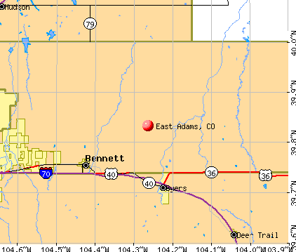
Points of interest:
Notable locations in East Adams: Living Springs Ranch (A), Sunnydale Community House (B), Adams County Road Station (C), Munson Ranch (D), Staple D Ranch (E), Bigger Ranch (F), Valhalla Ranch (G), Blessed Creek Farm (H), Calhoun Ranch (I), Causey Farms (J), Bijou Hill Dairy (K), Bennett Fire Protection District Station 93 (L), Bennett Fire Protection District Station 95 (M), Adams County Sheriff's Office Strasburg Substation (N), Strasburg Volunteer Fire / Rescue (O), Bennett Fire Protection District Station 92 (P), Bennett Fire Protection District Station 91 (Q). Display/hide their locations on the map
Cemeteries: Woolsey Cemetery (1), Bennett Cemetery (2). Display/hide their locations on the map
Reservoirs: Layne Reservoir (A), Bootleg Reservoir (B), Bramkamp Reservoir (C), No Name 1-1 Number 1 Reservoir (D), Horse Creek Reservoir (E), Moore Reservoir Number 4 (F), Simpsons Reservoir (G), Boot Lake Reservoir (H). Display/hide their locations on the map
Streams, rivers, and creeks: Little Comanche Creek (A), East Bijou Creek (B), West Bijou Creek (C), Sherman Ranch Slough (D), Little Muddy Creek (E), Poision Springs Creek (F), West Fork San Arroyo Creek (G), Hoffman Creek (H), Wolf Creek (I). Display/hide their locations on the map
| This place: | 2.8 people |
| Colorado: | 2.5 people |
| This place: | 74.8% |
| Whole state: | 63.9% |
| This place: | 5.7% |
| Whole state: | 6.5% |
Likely homosexual households (counted as self-reported same-sex unmarried-partner households)
- Lesbian couples: 0.4% of all households
- Gay men: 0.4% of all households
| This place: | 4.2% |
| Whole state: | 9.3% |
| This place: | 1.8% |
| Whole state: | 4.1% |
For population 15 years and over in East Adams:
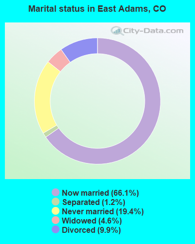
- Never married: 19.4%
- Now married: 66.1%
- Separated: 1.2%
- Widowed: 4.6%
- Divorced: 9.9%
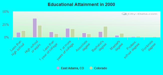
For population 25 years and over in East Adams:
- High school or higher: 90.1%
- Bachelor's degree or higher: 16.3%
- Graduate or professional degree: 5.2%
- Unemployed: 2.2%
- Mean travel time to work (commute): 31.2 minutes
| Here: | 8.5 |
| Colorado average: | 11.8 |
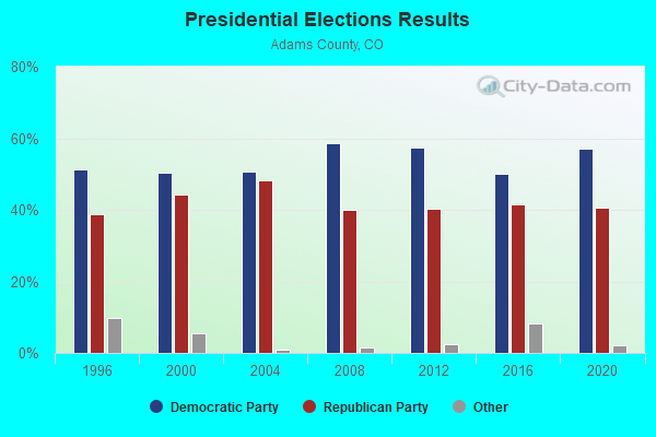
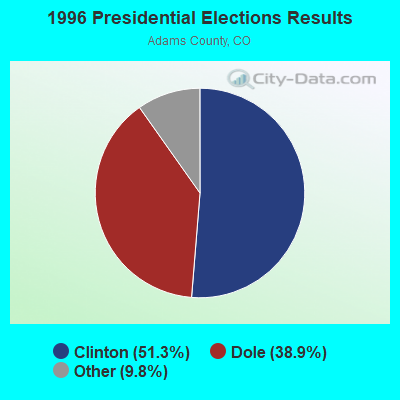
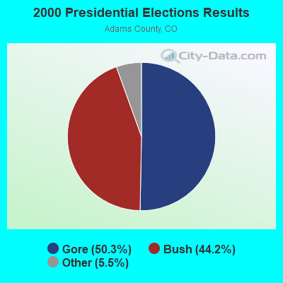
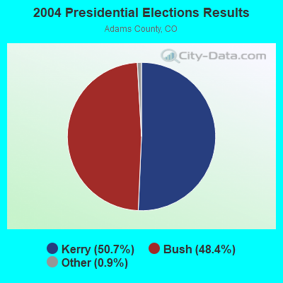
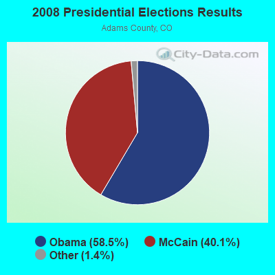
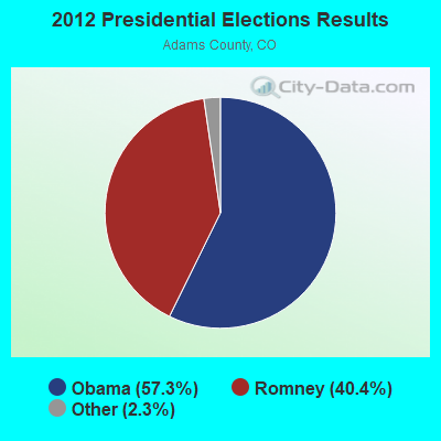
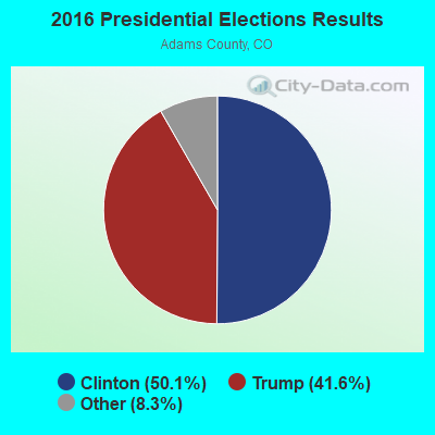
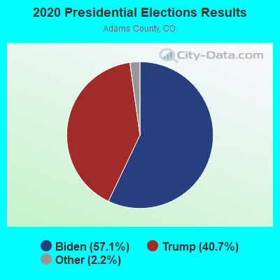
Graphs represent county-level data. Detailed 2008 Election Results
Religion statistics for East Adams, CO (based on Adams County data)
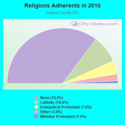
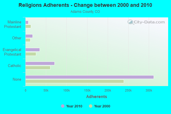
| Religion | Adherents | Congregations |
|---|---|---|
| Catholic | 70,598 | 11 |
| Evangelical Protestant | 34,568 | 159 |
| Other | 17,157 | 38 |
| Mainline Protestant | 7,133 | 33 |
| Black Protestant | 195 | 2 |
| Orthodox | - | 1 |
| None | 311,952 | - |
Food Environment Statistics:
| Adams County: | 1.16 / 10,000 pop. |
| Colorado: | 1.50 / 10,000 pop. |
| This county: | 0.17 / 10,000 pop. |
| Colorado: | 0.15 / 10,000 pop. |
| Here: | 0.21 / 10,000 pop. |
| State: | 0.45 / 10,000 pop. |
| Adams County: | 2.47 / 10,000 pop. |
| Colorado: | 3.13 / 10,000 pop. |
| Adams County: | 4.66 / 10,000 pop. |
| Colorado: | 8.99 / 10,000 pop. |
| This county: | 6.8% |
| Colorado: | 5.3% |
| Here: | 24.3% |
| Colorado: | 18.4% |
| Here: | 10.0% |
| State: | 9.6% |
11.65% of this county's 2021 resident taxpayers lived in other counties in 2020 ($55,974 average adjusted gross income)
| Here: | 11.65% |
| Colorado average: | 11.28% |
0.01% of residents moved from foreign countries ($73 average AGI)
Adams County: 0.01% Colorado average: 0.05%
Top counties from which taxpayers relocated into this county between 2020 and 2021:
| from Denver County, CO | |
| from Jefferson County, CO | |
| from Arapahoe County, CO |
11.37% of this county's 2020 resident taxpayers moved to other counties in 2021 ($59,124 average adjusted gross income)
| Here: | 11.37% |
| Colorado average: | 11.05% |
0.01% of residents moved to foreign countries ($78 average AGI)
Adams County: 0.01% Colorado average: 0.03%
Top counties to which taxpayers relocated from this county between 2020 and 2021:
| to Denver County, CO | |
| to Jefferson County, CO | |
| to Arapahoe County, CO |
Strongest AM radio stations in East Adams:
- KLTT (670 AM; 50 kW; COMMERCE CITY, CO; Owner: KLZ RADIO, INC.)
- KMXA (1090 AM; 50 kW; AURORA, CO; Owner: ENTRAVISION HOLDINGS, LLC)
- KOA (850 AM; 50 kW; DENVER, CO; Owner: JACOR BROADCASTING OF COLORADO, INC.)
- KKZN (760 AM; 50 kW; THORNTON, CO; Owner: JACOR BROADCASTING OF COLORADO, INC.)
- KLMO (1060 AM; 30 kW; LONGMONT, CO; Owner: PILGRIM COMMUNICATIONS, INC.)
- KSIR (1010 AM; 25 kW; BRUSH, CO; Owner: JMS BROADCASTING, LLC)
- KCUV (1510 AM; 25 kW; LITTLETON, CO; Owner: PEOPLE WIRELESS, INC.)
- KNRC (1150 AM; 10 kW; ENGLEWOOD, CO; Owner: NRC BROADCASTING, INC.)
- KRKS (990 AM; 10 kW; DENVER, CO; Owner: SALEM MEDIA OF COLORADO, INC.)
- KNUS (710 AM; 5 kW; DENVER, CO; Owner: SALEM MEDIA OF COLORADO, INC.)
- KLZ (560 AM; 5 kW; DENVER, CO; Owner: KLZ RADIO, INC.)
- KHOW (630 AM; 5 kW; DENVER, CO; Owner: CITICASTERS LICENSES, L.P.)
- KEZW (1430 AM; 10 kW; AURORA, CO; Owner: ENTERCOM DENVER LICENSE, LLC)
Strongest FM radio stations in East Adams:
- KBRU-FM (101.7 FM; FORT MORGAN, CO; Owner: ON-AIR FAMILY, LLC)
- KAVD (103.1 FM; LIMON, CO; Owner: THE MEADOWLARK GROUP, INC.)
- KJMN (92.1 FM; CASTLE ROCK, CO; Owner: ENTRAVISION HOLDINGS, LLC)
- KQMT (99.5 FM; DENVER, CO; Owner: ENTERCOM DENVER LICENSE, LLC)
- KJCD (104.3 FM; LONGMONT, CO; Owner: JEFFERSON-PILOT COMMUNICATIONS COMPANY OF COLORADO)
- KDJM (92.5 FM; BROOMFIELD, CO; Owner: INFINITY RADIO OPERATIONS INC.)
- KALC (105.9 FM; DENVER, CO; Owner: ENTERCOM DENVER LICENSE, LLC)
- KBPI (106.7 FM; DENVER, CO; Owner: JACOR BROADCASTING OF COLORADO, INC.)
- KTCL (93.3 FM; FORT COLLINS, CO; Owner: JACOR BROADCASTING OF COLORADO, INC.)
- KOSI (101.1 FM; DENVER, CO; Owner: ENTERCOM DENVER LICENSE, LLC)
- KFMD (95.7 FM; DENVER, CO; Owner: CITICASTERS LICENSES, L.P.)
- KRFX (103.5 FM; DENVER, CO; Owner: JACOR BROADCASTING OF COLORADO, INC.)
- KBCO-FM (97.3 FM; BOULDER, CO; Owner: CITICASTERS LICENSES, L.P.)
- KQKS (107.5 FM; LAKEWOOD, CO; Owner: JEFFERSON-PILOT COMMUNICATIONS COMPANY OF COLORADO)
- KAGM (102.3 FM; STRASBURG, CO; Owner: KAGM, LLC)
- KSIR-FM1 (107.1 FM; HUDSON, CO; Owner: KKDD-FM BROADCASTERS)
TV broadcast stations around East Adams:
- KMGH-TV (Channel 7; DENVER, CO; Owner: MCGRAW-HILL BROADCASTING COMPANY, INC.)
- KDEN (Channel 25; LONGMONT, CO; Owner: LONGMONT CHANNEL 25, INC.)
- K48FW (Channel 48; DENVER, CO; Owner: TRINITY BROADCASTING NETWORK)
- KRMA-TV (Channel 6; DENVER, CO; Owner: ROCKY MOUNTAIN PUBLIC BROADCASTING NETWORK, INC.)
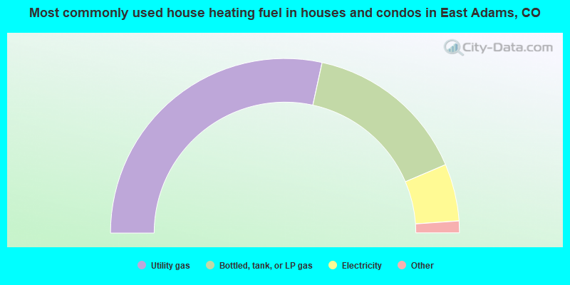
- 56.9%Utility gas
- 30.4%Bottled, tank, or LP gas
- 10.6%Electricity
- 1.5%Wood
- 0.4%Solar energy
- 0.3%Fuel oil, kerosene, etc.
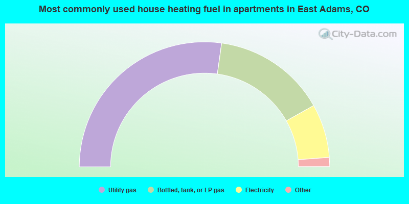
- 54.4%Utility gas
- 29.3%Bottled, tank, or LP gas
- 13.9%Electricity
- 1.3%Other fuel
- 0.5%Coal or coke
- 0.5%Wood
East Adams compared to Colorado state average:
- Unemployed percentage significantly below state average.
- Black race population percentage significantly below state average.
- Hispanic race population percentage significantly below state average.
- Foreign-born population percentage significantly below state average.
- Renting percentage below state average.
- Length of stay since moving in significantly above state average.
- Number of rooms per house significantly below state average.
- House age significantly below state average.
- Percentage of population with a bachelor's degree or higher below state average.
East Adams on our top lists:
- #9 on the list of "Top 101 cities with largest percentage of males in industries: furniture and home furnishing merchant wholesalers (population 5,000+)"
- #10 on the list of "Top 101 cities with largest percentage of females in industries: air transportation (population 5,000+)"
- #14 on the list of "Top 101 cities with largest percentage of females in occupations: supervisors of transportation and material moving workers (population 5,000+)"
- #14 on the list of "Top 101 cities with largest percentage of males in industries: air transportation (population 5,000+)"
- #18 on the list of "Top 101 cities with largest percentage of males in industries: motor vehicles, parts and supplies merchant wholesalers (population 5,000+)"
- #19 on the list of "Top 101 cities with largest percentage of males in occupations: driver/sales workers and truck drivers (population 5,000+)"
- #24 on the list of "Top 101 cities with largest percentage of females in occupations: air transportation workers (population 5,000+)"
- #26 on the list of "Top 101 cities with largest percentage of females in industries: truck transportation (population 5,000+)"
- #32 on the list of "Top 101 cities with the most cars per house, population 5,000+"
- #35 on the list of "Top 101 cities with largest percentage of females in occupations: farmers and farm managers (population 5,000+)"
- #37 on the list of "Top 101 cities with largest percentage of females in industries: warehousing and storage (population 5,000+)"
- #39 on the list of "Top 100 highest located cities (pop. 5,000+)"
- #39 on the list of "Top 101 cities with largest percentage of females in industries: gasoline stations (population 5,000+)"
- #41 on the list of "Top 101 cities with largest percentage of males in industries: truck transportation (population 5,000+)"
- #43 on the list of "Top 101 cities with largest percentage of males in occupations: farmers and farm managers (population 5,000+)"
- #43 on the list of "Top 101 cities with largest percentage of females in occupations: legal support workers (population 5,000+)"
- #46 on the list of "Top 101 cities with largest percentage of females in industries: farm product raw materials merchant wholesalers (population 5,000+)"
- #54 on the list of "Top 101 cities with largest percentage of females in industries: machinery, equipment, and supplies merchant wholesalers (population 5,000+)"
- #56 on the list of "Top 101 cities with largest percentage of females in industries: other transportation, and support activities, and couriers (population 5,000+)"
- #58 on the list of "Top 101 cities with largest percentage of females in industries: u. s. postal service (population 5,000+)"
- #3 on the list of "Top 101 counties with the highest Nitrogen Dioxide air pollution readings in 2012 (ppm)"
- #24 on the list of "Top 101 counties with the highest carbon monoxide air pollution readings in 2012 (ppm)"
- #32 on the list of "Top 101 counties with the lowest percentage of residents that visited a dentist within the past year"
- #59 on the list of "Top 101 counties with the lowest percentage of residents relocating from foreign countries between 2010 and 2011 (pop. 50,000+)"
- #59 on the list of "Top 101 counties with the largest decrease in the number of infant deaths per 1000 residents 2000-2006 to 2007-2013 (pop. 50,000+)"