Edison, Georgia
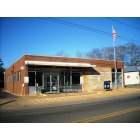
Edison: Edison Post Office
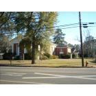
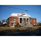
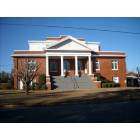
Edison: Edison United Methodist Church
Edison: Edison United Methodist Church
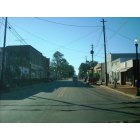
Edison: Downtown Edison
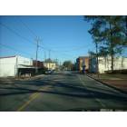
Edison: Downtown Edison
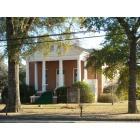
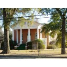
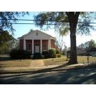
Edison: Edison Baptist Church
Edison: Edison United Methodist Church
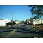
Edison: Downtown Edison
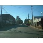
Edison: Downtown Edison
Edison: Edison Baptist Church
Edison: Edison United Methodist Church
- see
16
more - add
your
Submit your own pictures of this city and show them to the world
- OSM Map
- General Map
- Google Map
- MSN Map

Population change since 2000: -12.2%
| Males: 474 | |
| Females: 702 |
| Median resident age: | 43.7 years |
| Georgia median age: | 37.6 years |
Zip codes: 39846.
| Edison: | $37,003 |
| GA: | $72,837 |
Estimated per capita income in 2022: $18,174 (it was $10,409 in 2000)
Edison city income, earnings, and wages data
Estimated median house or condo value in 2022: $72,324 (it was $43,900 in 2000)
| Edison: | $72,324 |
| GA: | $297,400 |
Mean prices in 2022: all housing units: $78,108; detached houses: $99,608; mobile homes: $29,011
Median gross rent in 2022: $695.
(15.5% for White Non-Hispanic residents, 46.3% for Black residents)
Detailed information about poverty and poor residents in Edison, GA
Compare current foreclosures near Edison, GA:
| Photo | Address | Area | Beds / Baths | Price | Details |
|---|---|---|---|---|---|

|
#1
Booker Washington St
Edison, GA 39846
|
- sq. feet
|
- baths - beds |
show details | |

|
#2
Hartford St
Edison, GA 39846
|
- sq. feet
|
- baths - beds |
show details | |

|
#3
Turner St
Edison, GA 39846
|
- sq. feet
|
- baths - beds |
show details | |

|
#4
W Phelps St
Shellman, GA 39886
|
2,841 sq. feet
|
2 baths 4 beds |
$220,000
|
show details |

|
#5
Nelson Coffin Dr
Cuthbert, GA 39840
|
1,200 sq. feet
|
1 baths 3 beds |
show details | |

|
#6
Buford Cir
Shellman, GA 39886
|
1,024 sq. feet
|
2 baths 3 beds |
show details | |

|
#7
Ga Highway 266
Coleman, GA 39836
|
1,158 sq. feet
|
2 baths 2 beds |
show details | |

|
#8
Us Highway 27
Blakely, GA 39823
|
1,190 sq. feet
|
1 baths 3 beds |
show details | |

|
#9
Court St
Cuthbert, GA 39840
|
1,479 sq. feet
|
1 baths 2 beds |
show details | |

|
#10
Us Highway 82 W
Cuthbert, GA 39840
|
1,627 sq. feet
|
2 baths 3 beds |
show details |
| Photo | Address | Area | Beds / Baths | Price | Details |
|---|---|---|---|---|---|

|
#11
Tote Rd
Cuthbert, GA 39840
|
1,440 sq. feet
|
1 baths 3 beds |
show details | |

|
#12
S Central Ave
Blakely, GA 39823
|
1,600 sq. feet
|
2 baths - beds |
show details | |

|
#13
Rose Dr
Blakely, GA 39823
|
2,220 sq. feet
|
2 baths - beds |
show details | |

|
#14
Howell St
Blakely, GA 39823
|
1,425 sq. feet
|
1 baths - beds |
show details | |

|
#15
Jenkins Rd
Blakely, GA 39823
|
500 sq. feet
|
1 baths - beds |
show details | |

|
#16
S Central Ave
Blakely, GA 39823
|
1,622 sq. feet
|
2 baths - beds |
show details | |

|
#17
North Ave
Blakely, GA 39823
|
1,014 sq. feet
|
1 baths - beds |
show details | |

|
#18
Damascus St
Blakely, GA 39823
|
1,050 sq. feet
|
2 baths - beds |
show details | |

|
#19
Atkinson St
Cuthbert, GA 39840
|
1,075 sq. feet
|
2 baths - beds |
show details | |

|
#20
E South Blvd
Blakely, GA 39823
|
1,431 sq. feet
|
1 baths - beds |
show details |
| Photo | Address | Area | Beds / Baths | Price | Details |
|---|---|---|---|---|---|

|
#21
Nelson Coffin Dr
Cuthbert, GA 39840
|
1,325 sq. feet
|
1 baths - beds |
show details | |

|
#22
Thomas Grove Church Rd
Arlington, GA 39813
|
1,950 sq. feet
|
1 baths - beds |
show details | |

|
#23
Thomas Grove Church Rd
Arlington, GA 39813
|
1,026 sq. feet
|
1 baths - beds |
show details | |

|
#24
Harpe Rd
Arlington, GA 39813
|
984 sq. feet
|
1 baths - beds |
show details | |

|
#25
Havenwood Dr
Coleman, GA 39836
|
1,186 sq. feet
|
1 baths - beds |
show details | |

|
#26
Park Ave SE
Arlington, GA 39813
|
1,008 sq. feet
|
1 baths - beds |
show details | |

|
#27
Old Milford Rd
Leary, GA 39862
|
- sq. feet
|
- baths - beds |
show details | |

|
#28
E Phelps St
Shellman, GA 39886
|
- sq. feet
|
- baths - beds |
show details | |

|
#29
Plant St
Blakely, GA 39823
|
- sq. feet
|
- baths - beds |
show details | |

|
#30
Blakely Commons Cir
Blakely, GA 39823
|
- sq. feet
|
- baths - beds |
show details |
| Photo | Address | Area | Beds / Baths | Price | Details |
|---|---|---|---|---|---|

|
#31
Blakely Commons Cir
Blakely, GA 39823
|
- sq. feet
|
- baths - beds |
show details | |

|
#32
North Ave
Blakely, GA 39823
|
- sq. feet
|
- baths - beds |
show details | |

|
#33
Fannie Henry Ln
Arlington, GA 39813
|
- sq. feet
|
- baths - beds |
show details | |

|
#34
Old Leary Rd
Leary, GA 39862
|
- sq. feet
|
- baths - beds |
show details | |

|
#35
Avern Rd
Morgan, GA 39866
|
- sq. feet
|
- baths - beds |
show details | |

|
#36
Patmos Milford Hwy
Arlington, GA 39813
|
- sq. feet
|
- baths - beds |
show details | |

|
#37
Blakely Rd
Arlington, GA 39813
|
- sq. feet
|
- baths - beds |
show details | |

|
#38
North St
Cuthbert, GA 39840
|
- sq. feet
|
- baths - beds |
show details | |

|
#39
Harris Cir # 14
Cuthbert, GA 39840
|
- sq. feet
|
- baths - beds |
show details | |

|
#40
First Kolomoki Rd
Blakely, GA 39823
|
840 sq. feet
|
- baths - beds |
show details |
| Photo | Address | Area | Beds / Baths | Price | Details |
|---|---|---|---|---|---|

|
#41
Keene St
Cuthbert, GA 39840
|
- sq. feet
|
- baths - beds |
show details | |

|
#42
Chestnut St
Coleman, GA 39836
|
- sq. feet
|
- baths - beds |
show details | |

|
#43
Wall St
Cuthbert, GA 39840
|
- sq. feet
|
- baths - beds |
show details | |

|
#44
Lumpkin St
Cuthbert, GA 39840
|
- sq. feet
|
- baths - beds |
show details | |

|
#45
Ga Highway 216
Cuthbert, GA 39840
|
- sq. feet
|
- baths - beds |
show details | |

|
#46
Giles Hightower Rd
Blakely, GA 39823
|
1,536 sq. feet
|
- baths - beds |
show details | |

|
#47
Calhoun St
Cuthbert, GA 39840
|
- sq. feet
|
- baths - beds |
show details | |

|
#48
Calhoun St
Cuthbert, GA 39840
|
- sq. feet
|
- baths - beds |
show details | |

|
#49
Hill St # A
Cuthbert, GA 39840
|
- sq. feet
|
- baths - beds |
show details | |

|
Check over 1 million property listings on Foreclosure.com!
|
browse all offers | |||


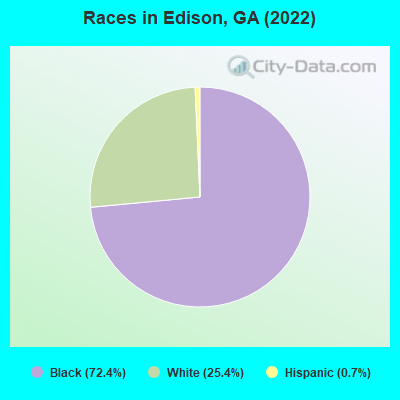
- 90572.4%Black alone
- 31725.4%White alone
- 90.7%Hispanic
Races in Edison detailed stats: ancestries, foreign born residents, place of birth
According to our research of Georgia and other state lists, there were 10 registered sex offenders living in Edison, Georgia as of May 18, 2024.
The ratio of all residents to sex offenders in Edison is 117 to 1.
Type |
2009 |
2010 |
2011 |
2012 |
2013 |
2014 |
2015 |
2016 |
2017 |
2018 |
2019 |
2020 |
2021 |
2022 |
|---|---|---|---|---|---|---|---|---|---|---|---|---|---|---|
| Murders (per 100,000) | 1 (80.6) | 0 (0.0) | 0 (0.0) | 0 (0.0) | 0 (0.0) | 0 (0.0) | 0 (0.0) | 0 (0.0) | 0 (0.0) | 0 (0.0) | 0 (0.0) | 0 (0.0) | 1 (71.7) | 0 (0.0) |
| Rapes (per 100,000) | 0 (0.0) | 0 (0.0) | 0 (0.0) | 0 (0.0) | 0 (0.0) | 0 (0.0) | 0 (0.0) | 0 (0.0) | 0 (0.0) | 0 (0.0) | 0 (0.0) | 0 (0.0) | 0 (0.0) | 1 (80.8) |
| Robberies (per 100,000) | 0 (0.0) | 3 (196.0) | 1 (64.5) | 0 (0.0) | 0 (0.0) | 0 (0.0) | 0 (0.0) | 1 (68.2) | 0 (0.0) | 0 (0.0) | 1 (69.9) | 0 (0.0) | 0 (0.0) | 0 (0.0) |
| Assaults (per 100,000) | 1 (80.6) | 3 (196.0) | 3 (193.4) | 1 (64.0) | 0 (0.0) | 1 (67.7) | 1 (68.4) | 5 (340.8) | 6 (417.5) | 0 (0.0) | 2 (139.9) | 2 (144.9) | 1 (71.7) | 1 (80.8) |
| Burglaries (per 100,000) | 6 (483.5) | 9 (587.9) | 10 (644.7) | 4 (256.1) | 5 (340.1) | 4 (270.8) | 1 (68.4) | 2 (136.3) | 1 (69.6) | 2 (137.1) | 1 (69.9) | 0 (0.0) | 1 (71.7) | 6 (485.0) |
| Thefts (per 100,000) | 8 (644.6) | 6 (391.9) | 11 (709.2) | 6 (384.1) | 12 (816.3) | 4 (270.8) | 0 (0.0) | 3 (204.5) | 2 (139.2) | 2 (137.1) | 6 (419.6) | 1 (72.5) | 0 (0.0) | 17 (1,374) |
| Auto thefts (per 100,000) | 0 (0.0) | 2 (130.6) | 0 (0.0) | 0 (0.0) | 0 (0.0) | 1 (67.7) | 0 (0.0) | 0 (0.0) | 0 (0.0) | 0 (0.0) | 1 (69.9) | 3 (217.4) | 1 (71.7) | 2 (161.7) |
| Arson (per 100,000) | 0 (0.0) | 0 (0.0) | 1 (64.5) | 0 (0.0) | 0 (0.0) | 0 (0.0) | 0 (0.0) | 0 (0.0) | 0 (0.0) | 0 (0.0) | 0 (0.0) | 0 (0.0) | 1 (71.7) | 0 (0.0) |
| City-Data.com crime index | 236.9 | 165.3 | 131.5 | 46.1 | 56.5 | 48.7 | 18.5 | 106.3 | 93.9 | 15.1 | 76.2 | 49.3 | 168.6 | 182.7 |
The City-Data.com crime index weighs serious crimes and violent crimes more heavily. Higher means more crime, U.S. average is 246.1. It adjusts for the number of visitors and daily workers commuting into cities.
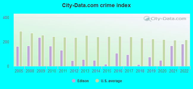
Crime rate in Edison detailed stats: murders, rapes, robberies, assaults, burglaries, thefts, arson
Full-time law enforcement employees in 2021, including police officers: 5 (4 officers - 1 male; 3 female).
| Officers per 1,000 residents here: | 2.87 |
| Georgia average: | 2.45 |
 Recent articles from our blog. Our writers, many of them Ph.D. graduates or candidates, create easy-to-read articles on a wide variety of topics.


Latest news from Edison, GA collected exclusively by city-data.com from local newspapers, TV, and radio stations
Ancestries: American (19.6%).
Current Local Time: EST time zone
Elevation: 289 feet
Land area: 2.33 square miles.
Population density: 505 people per square mile (low).

4 residents are foreign born
| This city: | 0.3% |
| Georgia: | 10.4% |
| Edison city: | 0.7% ($300) |
| Georgia: | 0.9% ($919) |
Nearest city with pop. 50,000+: West Dougherty, GA (31.9 miles  , pop. 59,680).
Nearest city with pop. 200,000+: Montgomery, AL (106.0 miles , pop. 201,568).
Nearest city with pop. 1,000,000+: Houston, TX (645.2 miles , pop. 1,953,631).
Nearest cities:
Latitude: 31.56 N, Longitude: 84.74 W
Area code: 229

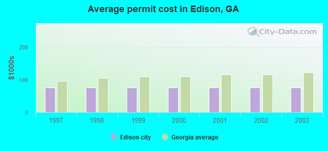
Single-family new house construction building permits:
- 2003: 1 building, cost: $75,900
- 2002: 1 building, cost: $75,900
- 2001: 1 building, cost: $75,900
- 2000: 1 building, cost: $75,900
- 1999: 1 building, cost: $75,900
- 1998: 1 building, cost: $75,900
- 1997: 1 building, cost: $75,900
| Here: | 2.6% |
| Georgia: | 2.9% |
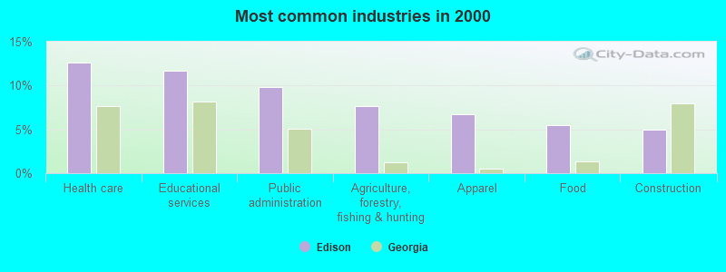
- Health care (12.6%)
- Educational services (11.7%)
- Public administration (9.8%)
- Agriculture, forestry, fishing & hunting (7.6%)
- Apparel (6.7%)
- Food (5.4%)
- Construction (5.0%)
- Agriculture, forestry, fishing & hunting (14.6%)
- Construction (9.9%)
- Food (8.5%)
- Public administration (8.0%)
- Educational services (7.5%)
- Paper (3.8%)
- Health care (3.8%)
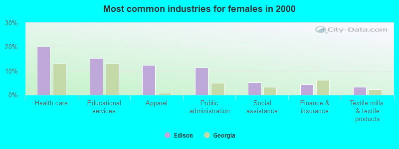
- Health care (20.2%)
- Educational services (15.3%)
- Apparel (12.5%)
- Public administration (11.3%)
- Social assistance (5.2%)
- Finance & insurance (4.4%)
- Textile mills & textile products (3.2%)
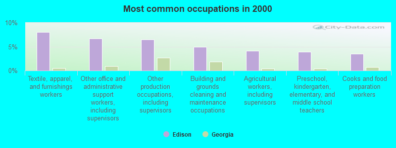
- Textile, apparel, and furnishings workers (8.0%)
- Other office and administrative support workers, including supervisors (6.7%)
- Other production occupations, including supervisors (6.5%)
- Building and grounds cleaning and maintenance occupations (5.0%)
- Agricultural workers, including supervisors (4.1%)
- Preschool, kindergarten, elementary, and middle school teachers (3.9%)
- Cooks and food preparation workers (3.5%)
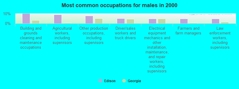
- Building and grounds cleaning and maintenance occupations (9.9%)
- Agricultural workers, including supervisors (9.0%)
- Other production occupations, including supervisors (8.0%)
- Driver/sales workers and truck drivers (5.2%)
- Electrical equipment mechanics and other installation, maintenance, and repair workers, including supervisors (4.7%)
- Farmers and farm managers (4.7%)
- Law enforcement workers, including supervisors (4.7%)
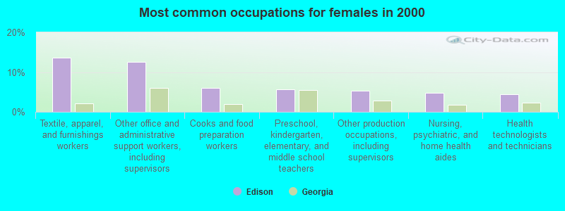
- Textile, apparel, and furnishings workers (13.7%)
- Other office and administrative support workers, including supervisors (12.5%)
- Cooks and food preparation workers (6.0%)
- Preschool, kindergarten, elementary, and middle school teachers (5.6%)
- Other production occupations, including supervisors (5.2%)
- Nursing, psychiatric, and home health aides (4.8%)
- Health technologists and technicians (4.4%)
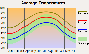
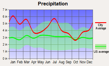
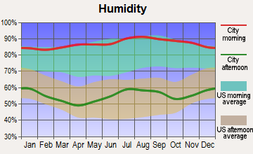
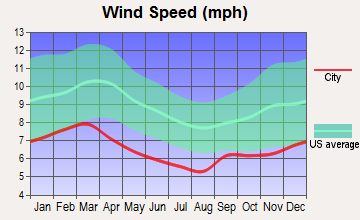
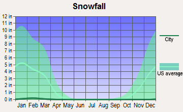
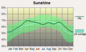
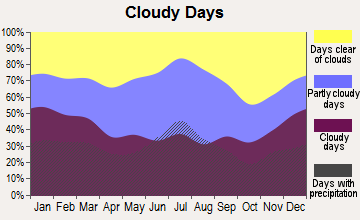
Average climate in Edison, Georgia
Based on data reported by over 4,000 weather stations
Tornado activity:
Edison-area historical tornado activity is slightly above Georgia state average. It is 50% greater than the overall U.S. average.
On 4/23/1971, a category F3 (max. wind speeds 158-206 mph) tornado 15.8 miles away from the Edison city center injured one person and caused between $50,000 and $500,000 in damages.
On 12/29/1973, a category F3 tornado 25.8 miles away from the city center injured 2 people and caused between $500,000 and $5,000,000 in damages.
Earthquake activity:
Edison-area historical earthquake activity is significantly above Georgia state average. It is 2% greater than the overall U.S. average.On 10/24/1997 at 08:35:17, a magnitude 4.9 (4.8 MB, 4.2 MS, 4.9 LG, Depth: 6.2 mi, Class: Light, Intensity: IV - V) earthquake occurred 152.7 miles away from the city center
On 8/2/1974 at 08:52:09, a magnitude 4.9 (4.3 MB, 4.9 LG) earthquake occurred 206.6 miles away from Edison center
On 4/29/2003 at 08:59:39, a magnitude 4.9 (4.4 MB, 4.6 MW, 4.9 LG) earthquake occurred 209.3 miles away from the city center
On 1/18/1999 at 07:00:53, a magnitude 4.8 (4.8 MB, 4.0 LG, Depth: 0.6 mi) earthquake occurred 194.5 miles away from Edison center
On 4/29/2003 at 08:59:39, a magnitude 4.6 (4.6 MW, Depth: 12.3 mi) earthquake occurred 209.3 miles away from Edison center
On 6/24/1975 at 11:11:36, a magnitude 4.5 (4.5 MB) earthquake occurred 234.3 miles away from Edison center
Magnitude types: regional Lg-wave magnitude (LG), body-wave magnitude (MB), surface-wave magnitude (MS), moment magnitude (MW)
Natural disasters:
The number of natural disasters in Calhoun County (8) is smaller than the US average (15).Major Disasters (Presidential) Declared: 5
Emergencies Declared: 1
Causes of natural disasters: Tornadoes: 4, Floods: 3, Storms: 3, Hurricanes: 2, Tropical Storms: 2, Winds: 2, Heavy Rain: 1, Other: 1 (Note: some incidents may be assigned to more than one category).

Hospitals and medical centers in Edison:
Other hospitals and medical centers near Edison:
Airports located in Edison:
- Mclendon Airport (GA48) (Runways: 1)
Colleges/universities with over 2000 students nearest to Edison:
- Darton State College (about 32 miles; Albany, GA; Full-time enrollment: 5,000)
- Albany Technical College (about 34 miles; Albany, GA; FT enrollment: 3,707)
- Albany State University (about 36 miles; Albany, GA; FT enrollment: 3,662)
- Georgia Southwestern State University (about 47 miles; Americus, GA; FT enrollment: 2,689)
- George C Wallace State Community College-Dothan (about 47 miles; Dothan, AL; FT enrollment: 3,611)
- Bainbridge State College (about 48 miles; Bainbridge, GA; FT enrollment: 2,308)
- Columbus State University (about 67 miles; Columbus, GA; FT enrollment: 6,876)
Public high schools in Edison:
- CALHOUN COUNTY HIGH SCHOOL (Students: 291, Location: 700 MANRY ST, Grades: 9-12)
- PATAULA CHARTER ACADEMY (Location: 18637 HARTFORD ST, Grades: KG-10, Charter school)
Public elementary/middle school in Edison:
- CALHOUN COUNTY MIDDLE SCHOOL (Students: 333, Location: 18772 HARTFORD ST, Grades: 6-8)
Points of interest:
Notable location: Edison Volunteer Fire Department (A). Display/hide its location on the map
Church in Edison: Edison Baptist Church (A). Display/hide its location on the map
Cemetery: Saint Stevens Cemetery (1). Display/hide its location on the map
Birthplace of: Rodney Dent - Basketball player.
Drinking water stations with addresses in Edison and their reported violations in the past:
EDISON (Population served: 1,568, Groundwater):Past monitoring violations:
- Follow-up Or Routine LCR Tap M/R - In OCT-01-1996, Contaminant: Lead and Copper Rule. Follow-up actions: St Compliance achieved (AUG-13-1997), St Intentional no-action (OCT-01-1997), St Public Notif requested (DEC-19-1997)
- 3 routine major monitoring violations
| This city: | 2.5 people |
| Georgia: | 2.6 people |
| This city: | 58.0% |
| Whole state: | 68.5% |
| This city: | 4.2% |
| Whole state: | 5.9% |
Likely homosexual households (counted as self-reported same-sex unmarried-partner households)
- Lesbian couples: 0.0% of all households
- Gay men: 0.2% of all households
64 people in nursing homes in 2000
15 people in other noninstitutional group quarters in 2000
Banks with branches in Edison (2011 data):
- The Bank of Edison: The Bank Of Edison at 476 Turner Street, branch established on 1904/10/01. Info updated 2010/06/02: Bank assets: $41.3 mil, Deposits: $33.1 mil, local headquarters, positive income, Agricultural Specialization, 1 total offices, Holding Company: Boe Bancshares, Inc.
For population 15 years and over in Edison:
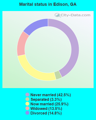
- Never married: 42.5%
- Now married: 25.9%
- Separated: 3.3%
- Widowed: 13.5%
- Divorced: 14.8%
For population 25 years and over in Edison:
- High school or higher: 76.3%
- Bachelor's degree or higher: 9.7%
- Graduate or professional degree: 1.0%
- Unemployed: 7.3%
- Mean travel time to work (commute): 22.0 minutes
| Here: | 9.7 |
| Georgia average: | 12.2 |
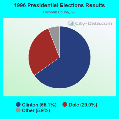
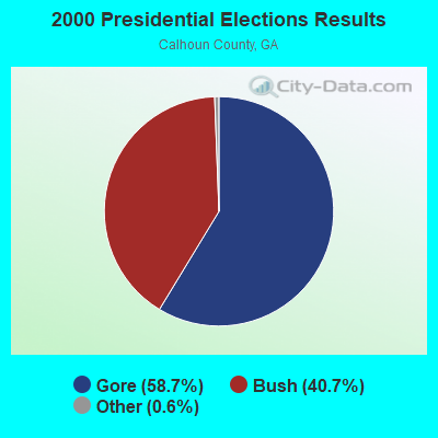
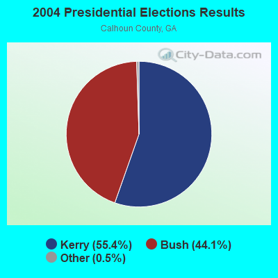
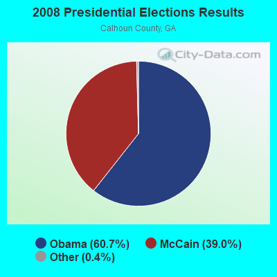
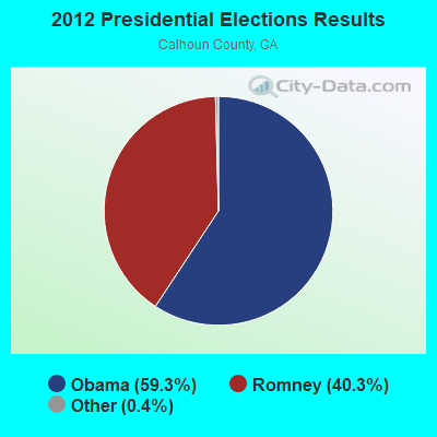
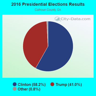
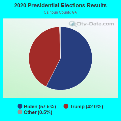
Graphs represent county-level data. Detailed 2008 Election Results
Religion statistics for Edison, GA (based on Calhoun County data)
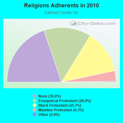
| Religion | Adherents | Congregations |
|---|---|---|
| Evangelical Protestant | 1,872 | 10 |
| Black Protestant | 1,719 | 10 |
| Mainline Protestant | 425 | 9 |
| Other | 26 | - |
| Catholic | - | - |
| None | 2,652 | - |
Food Environment Statistics:
| Calhoun County: | 3.29 / 10,000 pop. |
| State: | 1.91 / 10,000 pop. |
| Calhoun County: | 8.22 / 10,000 pop. |
| Georgia: | 5.12 / 10,000 pop. |
| Calhoun County: | 4.93 / 10,000 pop. |
| Georgia: | 7.41 / 10,000 pop. |
| This county: | 13.7% |
| Georgia: | 10.4% |
| Calhoun County: | 33.3% |
| State: | 27.8% |
| This county: | 14.2% |
| Georgia: | 14.6% |
Health and Nutrition:
| Edison: | 46.7% |
| State: | 48.9% |
| Edison: | 42.8% |
| Georgia: | 46.5% |
| This city: | 30.6 |
| Georgia: | 28.9 |
| This city: | 18.2% |
| Georgia: | 20.4% |
| Edison: | 15.2% |
| Georgia: | 10.8% |
| This city: | 6.6 |
| Georgia: | 6.7 |
| Edison: | 37.3% |
| Georgia: | 33.5% |
| Edison: | 50.3% |
| State: | 56.2% |
| Here: | 82.9% |
| State: | 80.8% |
More about Health and Nutrition of Edison, GA Residents
| Local government employment and payroll (March 2022) | |||||
| Function | Full-time employees | Monthly full-time payroll | Average yearly full-time wage | Part-time employees | Monthly part-time payroll |
|---|---|---|---|---|---|
| Streets and Highways | 6 | $28,710 | $57,420 | 0 | $0 |
| Police Protection - Officers | 6 | $27,288 | $54,576 | 1 | $674 |
| Financial Administration | 2 | $3,788 | $22,728 | 0 | $0 |
| Other and Unallocable | 0 | $0 | 1 | $332 | |
| Firefighters | 0 | $0 | 1 | $412 | |
| Other Government Administration | 0 | $0 | 5 | $750 | |
| Totals for Government | 14 | $59,786 | $51,245 | 8 | $2,168 |
Edison government finances - Expenditure in 2017 (per resident):
- Current Operations - Gas Utilities: $291,000 ($247.45)
Central Staff Services: $238,000 ($202.38)
Police Protection: $235,000 ($199.83)
Water Utilities: $192,000 ($163.27)
Sewerage: $175,000 ($148.81)
Solid Waste Management: $160,000 ($136.05)
Regular Highways: $135,000 ($114.80)
Local Fire Protection: $5,000 ($4.25)
Libraries: $5,000 ($4.25)
Parks and Recreation: $5,000 ($4.25)
General Public Buildings: $1,000 ($0.85)
- General - Interest on Debt: $30,000 ($25.51)
Edison government finances - Revenue in 2017 (per resident):
- Charges - Solid Waste Management: $177,000 ($150.51)
Sewerage: $174,000 ($147.96)
Other: $41,000 ($34.86)
- Federal Intergovernmental - Housing and Community Development: $122,000 ($103.74)
General Local Government Support: $5,000 ($4.25)
- Local Intergovernmental - General Local Government Support: $72,000 ($61.22)
Other: $30,000 ($25.51)
- Miscellaneous - Fines and Forfeits: $33,000 ($28.06)
Rents: $7,000 ($5.95)
General Revenue - Other: $7,000 ($5.95)
- Revenue - Gas Utilities: $262,000 ($222.79)
Water Utilities: $80,000 ($68.03)
- State Intergovernmental - General Local Government Support: $22,000 ($18.71)
- Tax - Property: $255,000 ($216.84)
Insurance Premiums Sales: $96,000 ($81.63)
Alcoholic Beverage Sales: $29,000 ($24.66)
Occupation and Business License - Other: $12,000 ($10.20)
Edison government finances - Debt in 2017 (per resident):
- Long Term Debt - Beginning Outstanding - Unspecified Public Purpose: $856,000 ($727.89)
Outstanding Unspecified Public Purpose: $825,000 ($701.53)
Retired Unspecified Public Purpose: $31,000 ($26.36)
- Short Term Debt Outstanding - Beginning: $105,000 ($89.29)
End of Fiscal Year: $42,000 ($35.71)
Edison government finances - Cash and Securities in 2017 (per resident):
- Other Funds - Cash and Securities: $215,000 ($182.82)
- Sinking Funds - Cash and Securities: $75,000 ($63.78)
Strongest AM radio stations in Edison:
- WSTT (730 AM; 25 kW; THOMASVILLE, GA; Owner: MARION R. WILLIAMS)
- WJYZ (960 AM; 5 kW; ALBANY, GA; Owner: CLEAR CHANNEL BROADCASTING LICENSES, INC.)
- WMAC (940 AM; 50 kW; MACON, GA; Owner: CUMULUS LICENSING CORP.)
- WOOF (560 AM; 5 kW; DOTHAN, AL; Owner: WOOF, INC.)
- WGST (640 AM; 50 kW; ATLANTA, GA; Owner: CITICASTERS LICENSES, L.P.)
- WALG (1590 AM; 5 kW; ALBANY, GA; Owner: CUMULUS LICENSING CORP.)
- WQLS (1200 AM; 10 kW; OZARK, AL; Owner: STYLES BROADCASTING OF DOTHAN, INC.)
- WFVR (910 AM; 50 kW; VALDOSTA, GA; Owner: RAMA COMMUNICATIONS, INC.)
- WSB (750 AM; 50 kW; ATLANTA, GA; Owner: CXR HOLDINGS, INC.)
- WCNN (680 AM; 50 kW; NORTH ATLANTA, GA; Owner: DICKEY BROADCASTING COMPANY)
- WMGR (930 AM; 5 kW; BAINBRIDGE, GA; Owner: DECATUR BROADCASTING, INC.)
- WJEP (1020 AM; daytime; 10 kW; OCHLOCKNEE, GA; Owner: LIFELINE MINISTRIES, INCORPORATED)
- WMGA (1130 AM; 10 kW; MOULTRIE, GA; Owner: RADIO MOULTRIE, INC.)
Strongest FM radio stations in Edison:
- WRAK-FM (97.3 FM; BAINBRIDGE, GA; Owner: CLEAR CHANNEL BROADCASTING LICENSES, INC.)
- WKAK (104.5 FM; ALBANY, GA; Owner: CUMULUS LICENSING CORP.)
- WTVY-FM (95.5 FM; DOTHAN, AL; Owner: STYLES BROADCASTING OF DOTHAN, INC.)
- WBBK-FM (93.1 FM; BLAKELY, GA; Owner: MERCHANTS BROADCASTING SYSTEMS OF SW GA)
- WOOF-FM (99.7 FM; DOTHAN, AL; Owner: WOOF, INC.)
- W207AW (89.3 FM; CUTHBERT, GA; Owner: AMERICAN FAMILY ASSOCIATION)
- WJWV (90.9 FM; FORT GAINES, GA; Owner: GEORGIA PUBLIC TELECOMMUNICATIONS COMMISSION)
- WWXC (90.7 FM; ALBANY, GA; Owner: LAMAD MINISTRIES, INC.)
- WEGC (107.7 FM; SASSER, GA; Owner: CUMULUS LICENSING CORP.)
TV broadcast stations around Edison:
- WACS-TV (Channel 25; DAWSON, GA; Owner: GEORGIA PUBLIC TELECOMMUNICATIONS COMMISSION)
- WTVM (Channel 9; COLUMBUS, GA; Owner: RAYCOM AMERICA, INC.)
- WRBL (Channel 3; COLUMBUS, GA; Owner: MEDIA GENERAL BROADCASTING OF SO. CAROLINA HOLDINGS, INC.)
- W08DM (Channel 8; COLQUITT, GA; Owner: MS COMMUNICATIONS, LLC)
- WTLH (Channel 49; BAINBRIDGE, GA; Owner: WTLH LICENSE CORP.)
- WABW-TV (Channel 14; PELHAM, GA; Owner: GEORGIA PUBLIC TELECOMMUNICATIONS COMMISSION)
- W69DO (Channel 69; COLQUITT, GA; Owner: MS COMMUNICATIONS, LLC)
- W26BM (Channel 26; COLQUITT, GA; Owner: MS COMMUNICATIONS, LLC)
- W34CZ (Channel 34; ALBANY, GA; Owner: TRINITY BROADCASTING NETWORK)
- W45BL (Channel 45; COLQUITT, GA; Owner: MS COMMUNICATIONS, LLC)
- W51CQ (Channel 51; COLQUITT, GA; Owner: MS COMMUNICATIONS, LLC)
Edison fatal accident list:
- National Bridge Inventory (NBI) Statistics
- 15Number of bridges
- 167ft / 51.3mTotal length
- $80,404,000Total costs
- 15,975Total average daily traffic
- 842Total average daily truck traffic
- 23,025Total future (year 2021) average daily traffic
- New bridges - historical statistics
- 31920-1929
- 21930-1939
- 21960-1969
- 11970-1979
- 21980-1989
- 11990-1999
- 12000-2009
- 32020-2022
FCC Registered Antenna Towers:
15 (See the full list of FCC Registered Antenna Towers in Edison)FCC Registered Broadcast Land Mobile Towers:
6- 18859 Hartford Street (Lat: 31.560639 Lon: -84.728778), Type: Gtower, Structure height: 30.5 m, Overall height: 37 m, Call Sign: KIC380,
Assigned Frequencies: 154.280 MHz, 159.277 MHz, 159.330 MHz, 159.255 MHz, 159.270 MHz, 151.145 MHz, 151.100 MHz, 151.115 MHz, 151.242 MHz, 151.272 MHz... (+17 more), Grant Date: 06/29/2023, Expiration Date: 07/30/2033, Registrant: Gta Gfc Calhoun Unit, 5645 Riggins Mill Raod, Dry Branch, GA 31020, Phone: (478) 751-3494, Fax: (706) 864-9596, Email:
- City Hall Blvd Main St (Lat: 31.558500 Lon: -84.734083), Call Sign: KTS509,
Assigned Frequencies: 154.845 MHz, 154.905 MHz, 154.935 MHz, 155.370 MHz, Grant Date: 02/15/2024, Expiration Date: 02/27/2034, Registrant: Mobile Communications America, 3303 Gillionville Road, Albany, GA 31721, Phone: (229) 669-1061, Fax: (229) 436-3189, Email:
- Hwy 37 3 Mi Nw (Lat: 31.582944 Lon: -84.792694), Call Sign: KGK921, Licensee ID: L00659658,
Assigned Frequencies: 152.900 MHz, Grant Date: 04/08/2003, Expiration Date: 06/06/2013, Cancellation Date: 08/10/2013, Registrant: Mc Lendon, H T Dba H T Mc Lendon Co, 23110 Sr 37, Edison, GA 39846, Phone: (229) 835-2266
- Lot 158a Ga Hwy 37 (Lat: 31.554611 Lon: -84.734083), Call Sign: KKQ518,
Assigned Frequencies: 451.075 MHz, 456.075 MHz, 456.125 MHz, 456.575 MHz, Grant Date: 08/19/1997, Expiration Date: 08/19/2002, Cancellation Date: 04/16/2002, Registrant: Mcdermott, Will & Emery, 600 13th Street, Nw, Washington, DC 20005-3096, Phone: (202) 756-8281, Fax: (202) 756-8087, Email:
- Lat: 31.557778 Lon: -84.692222, Call Sign: WQAS214,
Assigned Frequencies: 463.375 MHz, 468.375 MHz, Grant Date: 07/27/2004, Expiration Date: 07/27/2014, Cancellation Date: 09/27/2014, Certifier: Roy Jackson Jr, Registrant: Albany Communications, Inc., 3303 Gillionville Rd, Albany, GA 31721, Phone: (229) 432-9301, Fax: (229) 436-3189
- Lat: 31.562444 Lon: -84.722944, Call Sign: WRUL575,
Assigned Frequencies: 461.418 MHz, 466.418 MHz, Grant Date: 09/08/2022, Expiration Date: 09/08/2032, Certifier: Charlie Montelongo, Registrant: Master Meter Inc., 101 Regency Parkway, Mansfield, TX 76063-5093, Phone: (817) 842-8000, Fax: (817) 842-8030, Email:
FCC Registered Microwave Towers:
1- 9AT3825A, Wayback Road & Jones Road (Lat: 31.585278 Lon: -84.723417), Type: Gtower, Structure height: 91.4 m, Call Sign: WSBQ371,
Assigned Frequencies: 11075.0 MHz, 11155.0 MHz, 11075.0 MHz, 11155.0 MHz, 11075.0 MHz, 11155.0 MHz, 11075.0 MHz, 11155.0 MHz, 11075.0 MHz, 11155.0 MHz... (+12 more), Grant Date: 03/05/2024, Expiration Date: 03/05/2034, Certifier: Jenny Knopf, Registrant: T-Mobile Usa, Inc., 12920 Se 38th Street, Bellevue, WA 98006, Phone: (425) 383-8401, Fax: (425) 383-4040, Email:
FAA Registered Aircraft:
2- Aircraft: PIPER PA-28-161 (Category: Land, Seats: 4, Weight: Up to 12,499 Pounds, Speed: 108 mph), Engine: LYCOMING 0-320 SERIES (180 HP) (Reciprocating)
N-Number: 2433M, N2433M, N-2433M, Serial Number: 28-7816285, Year manufactured: 1977, Airworthiness Date: 12/14/1977, Certificate Issue Date: 03/28/1980
Registrant (Individual): Glenn Mclendon, 23235 Sr 37, Edison, GA 39846 - Aircraft: CESSNA 182A (Category: Land, Seats: 4, Weight: Up to 12,499 Pounds, Speed: 119 mph), Engine: CONT MOTOR O-470 SERIES (230 HP) (Reciprocating)
N-Number: 3919D, N3919D, N-3919D, Serial Number: 34619, Year manufactured: 1957, Airworthiness Date: 08/24/1957, Certificate Issue Date: 04/20/2009
Registrant (Corporation): Owen Flying Service Inc, 803 Bell Farm Rd, Edison, GA 39846
Deregistered: Cancel Date: 09/04/2020
2002 - 2018 National Fire Incident Reporting System (NFIRS) incidents
- Fire incident types reported to NFIRS in Edison, GA
- 9852.7%Structure Fires
- 6032.3%Outside Fires
- 2211.8%Mobile Property/Vehicle Fires
- 63.2%Other
 According to the data from the years 2002 - 2018 the average number of fires per year is 11. The highest number of fire incidents - 34 took place in 2004, and the least - 0 in 2008. The data has an increasing trend.
 When looking into fire subcategories, the most incidents belonged to: Structure Fires (52.7%), and Outside Fires (32.3%).
| Most common first names in Edison, GA among deceased individuals | ||
| Name | Count | Lived (average) |
|---|---|---|
| Willie | 26 | 73.1 years |
| John | 24 | 74.7 years |
| James | 22 | 74.0 years |
| Mary | 20 | 80.7 years |
| Annie | 17 | 82.3 years |
| Robert | 13 | 66.9 years |
| Louise | 11 | 73.6 years |
| Hattie | 10 | 87.1 years |
| Ruby | 10 | 77.6 years |
| Henry | 10 | 83.2 years |
| Most common last names in Edison, GA among deceased individuals | ||
| Last name | Count | Lived (average) |
|---|---|---|
| Brown | 23 | 77.4 years |
| Jones | 22 | 74.2 years |
| Williams | 20 | 67.8 years |
| Lee | 13 | 78.6 years |
| Johnson | 13 | 77.8 years |
| Lewis | 12 | 74.4 years |
| Jackson | 12 | 81.6 years |
| Mitchell | 11 | 64.5 years |
| Davis | 11 | 76.6 years |
| Sanders | 11 | 77.2 years |
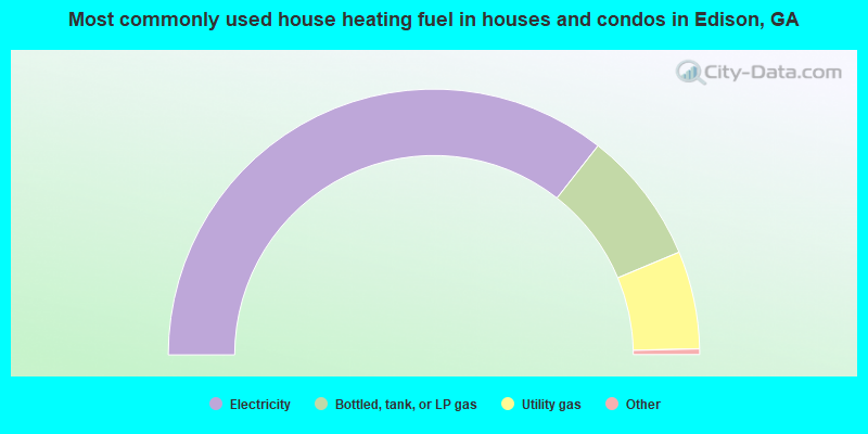
- 71.7%Electricity
- 16.3%Bottled, tank, or LP gas
- 12.0%Utility gas

- 87.4%Electricity
- 12.6%Utility gas
Edison compared to Georgia state average:
- Median household income below state average.
- Median house value significantly below state average.
- Unemployed percentage below state average.
- Black race population percentage above state average.
- Hispanic race population percentage significantly below state average.
- Median age below state average.
- Foreign-born population percentage significantly below state average.
- Length of stay since moving in significantly above state average.
- House age above state average.
- Institutionalized population percentage above state average.
- Number of college students significantly below state average.
- Percentage of population with a bachelor's degree or higher significantly below state average.