Everett, Georgia
Submit your own pictures of this place and show them to the world
- OSM Map
- General Map
- Google Map
- MSN Map

| Males: 8,203 | |
| Females: 8,566 |
| Median resident age: | 34.8 years |
| Georgia median age: | 33.4 years |
Zip code: 31525
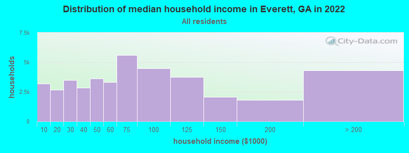
| Everett: | $72,070 |
| GA: | $72,837 |
Estimated per capita income in 2022: $36,645 (it was $19,642 in 2000)
Everett CCD income, earnings, and wages data
Estimated median house or condo value in 2022: $223,494 (it was $82,100 in 2000)
| Everett: | $223,494 |
| GA: | $297,400 |
Mean prices in 2022: all housing units: $382,705; detached houses: $404,159; townhouses or other attached units: $351,793; in 2-unit structures: $334,837; in 3-to-4-unit structures: $339,557; in 5-or-more-unit structures: $587,018; mobile homes: $100,066
Detailed information about poverty and poor residents in Everett, GA


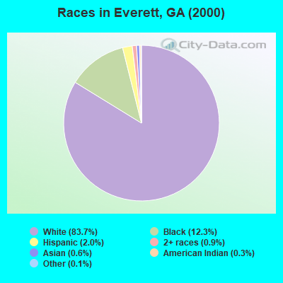
- 12,71183.7%White alone
- 1,87412.3%Black alone
- 2972.0%Hispanic
- 1420.9%Two or more races
- 880.6%Asian alone
- 480.3%American Indian alone
- 170.1%Other race alone
- 10.01%Native Hawaiian and Other
Pacific Islander alone
Races in Everett detailed stats: ancestries, foreign born residents, place of birth
 Recent articles from our blog. Our writers, many of them Ph.D. graduates or candidates, create easy-to-read articles on a wide variety of topics.
Current Local Time: EST time zone
Land area: 127.1 square miles.
Population density: 132 people per square mile (very low).

| Everett CCD: | 1.0% ($857) |
| Georgia: | 0.9% ($919) |
Nearest city with pop. 50,000+: Savannah, GA  (59.2 miles , pop. 131,510).
Nearest city with pop. 200,000+: Jacksonville, FL (66.1 miles , pop. 735,617).
Nearest city with pop. 1,000,000+: Philadelphia, PA (701.4 miles , pop. 1,517,550).
Nearest cities:
), ), ), ), )Latitude: 31.27 N, Longitude: 81.50 W
Area code commonly used in this area: 912

| Here: | 2.5% |
| Georgia: | 2.9% |
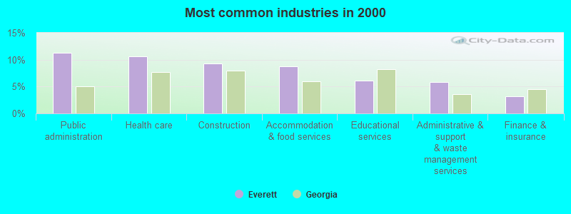
- Public administration (11.2%)
- Health care (10.6%)
- Construction (9.3%)
- Accommodation & food services (8.7%)
- Educational services (6.1%)
- Administrative & support & waste management services (5.8%)
- Finance & insurance (3.2%)
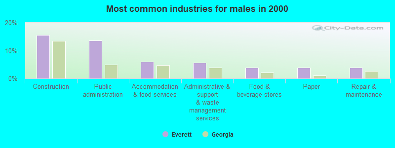
- Construction (15.5%)
- Public administration (13.6%)
- Accommodation & food services (6.0%)
- Administrative & support & waste management services (5.7%)
- Food & beverage stores (3.9%)
- Paper (3.9%)
- Repair & maintenance (3.9%)
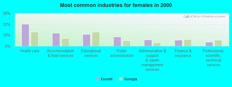
- Health care (20.3%)
- Accommodation & food services (11.9%)
- Educational services (10.8%)
- Public administration (8.4%)
- Administrative & support & waste management services (6.0%)
- Finance & insurance (5.7%)
- Professional, scientific, technical services (3.8%)
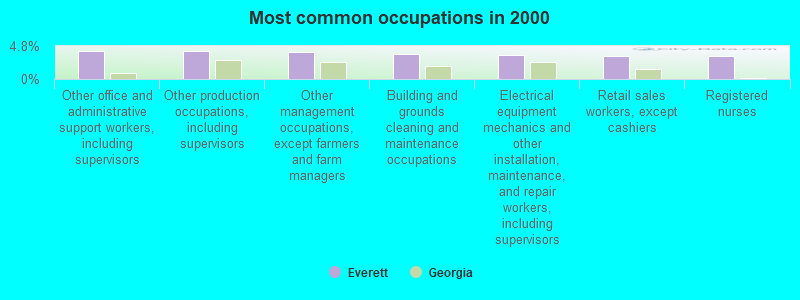
- Other office and administrative support workers, including supervisors (4.1%)
- Other production occupations, including supervisors (4.1%)
- Other management occupations, except farmers and farm managers (3.9%)
- Building and grounds cleaning and maintenance occupations (3.7%)
- Electrical equipment mechanics and other installation, maintenance, and repair workers, including supervisors (3.5%)
- Retail sales workers, except cashiers (3.4%)
- Registered nurses (3.3%)
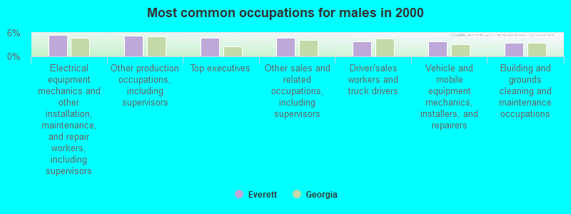
- Electrical equipment mechanics and other installation, maintenance, and repair workers, including supervisors (5.4%)
- Other production occupations, including supervisors (5.3%)
- Top executives (4.8%)
- Other sales and related occupations, including supervisors (4.7%)
- Driver/sales workers and truck drivers (3.8%)
- Vehicle and mobile equipment mechanics, installers, and repairers (3.8%)
- Building and grounds cleaning and maintenance occupations (3.5%)
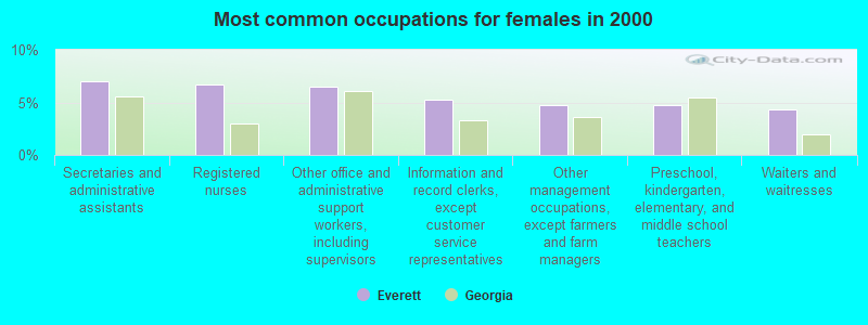
- Secretaries and administrative assistants (7.1%)
- Registered nurses (6.7%)
- Other office and administrative support workers, including supervisors (6.5%)
- Information and record clerks, except customer service representatives (5.3%)
- Other management occupations, except farmers and farm managers (4.8%)
- Preschool, kindergarten, elementary, and middle school teachers (4.7%)
- Waiters and waitresses (4.4%)
Average climate in Everett, Georgia
Based on data reported by over 4,000 weather stations


(lower is better)
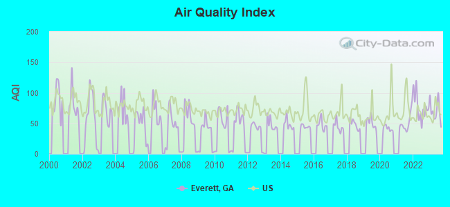
Air Quality Index (AQI) level in 2023 was 70.1. This is about average.
| City: | 70.1 |
| U.S.: | 72.6 |
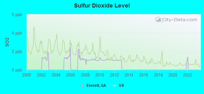
Sulfur Dioxide (SO2) [ppb] level in 2012 was 1.03. This is significantly better than average. Closest monitor was 3.5 miles away from the city center.
| City: | 1.03 |
| U.S.: | 1.51 |
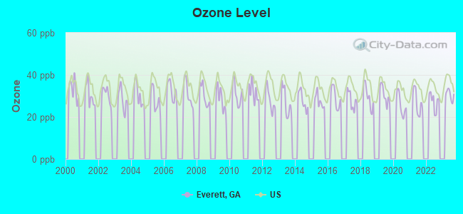
Ozone [ppb] level in 2023 was 30.5. This is about average. Closest monitor was 6.6 miles away from the city center.
| City: | 30.5 |
| U.S.: | 33.3 |

Particulate Matter (PM2.5) [µg/m3] level in 2023 was 8.96. This is about average. Closest monitor was 5.8 miles away from the city center.
| City: | 8.96 |
| U.S.: | 8.11 |
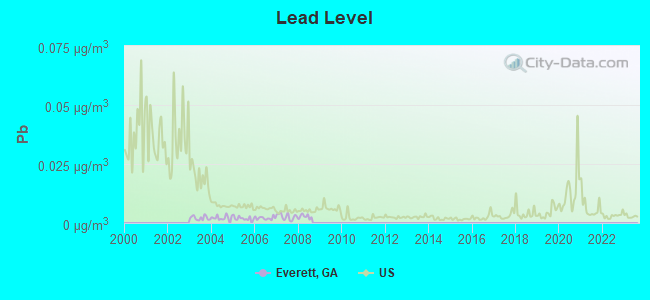
Lead (Pb) [µg/m3] level in 2008 was 0.00272. This is significantly better than average. Closest monitor was 5.7 miles away from the city center.
| City: | 0.00272 |
| U.S.: | 0.00931 |
Tornado activity:
Everett-area historical tornado activity is significantly below Georgia state average. It is 47% smaller than the overall U.S. average.
On 5/11/2008, a category F4 (max. wind speeds 207-260 mph) tornado 10.3 miles away from the Everett place center injured 9 people and caused $13 million in damages.
On 2/24/1963, a category F2 (max. wind speeds 113-157 mph) tornado 7.7 miles away from the place center caused between $500 and $5000 in damages.
Earthquake activity:
Everett-area historical earthquake activity is significantly above Georgia state average. It is 54% smaller than the overall U.S. average.On 11/22/1974 at 05:25:55, a magnitude 4.7 (4.7 MB, Class: Light, Intensity: IV - V) earthquake occurred 138.3 miles away from the city center
On 8/2/1974 at 08:52:09, a magnitude 4.9 (4.3 MB, 4.9 LG) earthquake occurred 189.2 miles away from the city center
On 8/21/1992 at 16:31:55, a magnitude 4.4 (4.1 MB, 4.1 LG, 4.4 LG, Depth: 6.2 mi) earthquake occurred 147.8 miles away from Everett center
On 11/11/2002 at 23:39:29, a magnitude 4.0 (4.0 MB, Depth: 1.5 mi) earthquake occurred 121.2 miles away from Everett center
On 2/15/2014 at 03:23:38, a magnitude 4.1 (4.1 MW, Depth: 3.2 mi) earthquake occurred 179.8 miles away from Everett center
On 7/13/2003 at 20:15:16, a magnitude 3.6 (3.6 MB, Depth: 3.1 mi, Class: Light, Intensity: II - III) earthquake occurred 83.0 miles away from the city center
Magnitude types: regional Lg-wave magnitude (LG), body-wave magnitude (MB), moment magnitude (MW)
Natural disasters:
The number of natural disasters in Glynn County (10) is smaller than the US average (15).Major Disasters (Presidential) Declared: 4
Emergencies Declared: 5
Causes of natural disasters: Hurricanes: 4, Floods: 2, Storms: 2, Drought: 1, Snowfall: 1, Tornado: 1, Tropical Storm: 1, Winter Storm: 1, Other: 1 (Note: some incidents may be assigned to more than one category).
Hospitals and medical centers near Everett:
- HOSPICE OF THE GOLDEN ISLES (Hospital, about 3 miles away; BRUNSWICK, GA)
- FRESENIUS MEDICAL CARE DIALYSIS OF GOLDEN ISLES (Dialysis Facility, about 3 miles away; BRUNSWICK, GA)
- BRUNSWICK DIALYSIS (Dialysis Facility, about 4 miles away; BRUNSWICK, GA)
- CARESOUTH/ ADVANTAGE HEALTHCARE (Home Health Center, about 4 miles away; BRUNSWICK, GA)
- HEARTLAND HOSPICE SERVICES ( BRUNSWICK ) (Hospital, about 6 miles away; BRUNSWICK, GA)
- SEARS MANOR NURSING HOME (Nursing Home, about 7 miles away; BRUNSWICK, GA)
- FORUM GROUP AT WILDWOOD PARK NSG AND REHAB CTR LLC (Nursing Home, about 7 miles away; BRUNSWICK, GA)
Colleges/universities with over 2000 students nearest to Everett:
- College of Coastal Georgia (about 9 miles; Brunswick, GA; Full-time enrollment: 2,447)
- Armstrong Atlantic State University (about 54 miles; Savannah, GA; FT enrollment: 6,399)
- South University–Savannah Online (about 56 miles; Savannah, GA; FT enrollment: 13,512)
- Savannah Technical College (about 58 miles; Savannah, GA; FT enrollment: 3,677)
- Savannah State University (about 59 miles; Savannah, GA; FT enrollment: 4,193)
- Savannah College of Art and Design (about 61 miles; Savannah, GA; FT enrollment: 9,964)
- Jacksonville University (about 64 miles; Jacksonville, FL; FT enrollment: 3,335)
Points of interest:
Notable locations in Everett: Camp Squawchee (A), Santo Domingo Mission Ruins (B), Hunters Siding (C), Altamaha Plantation (D), Coastal Pines Golf Club (E), Oak Grove Island Golf and Country Club (F), Golden Isles Marina (G), Hofwyl (H), Browns Lake Landing (I), Clarks Bluff Landing (J), Honeygall Landing (K), Glynn County Fire Department Station 5 (L), Glynn County Fire Department Station 8 (M), Glynn County Fire Department Station 3 (N). Display/hide their locations on the map
Churches in Everett include: Bethel Church (A), Coneys Temple (B), Pine Haven Church (C), Faith Church (D), Everett Church (E), Church of God of Prophecy (F), Northside Baptist Church (G), Lighthouse Baptist Church (H), Kingdom Hall of Jehovahs Witnesses (I). Display/hide their locations on the map
Cemeteries: Brunswick Memorial Park (1), Freedman Cemetery (2), Daniel Cemetery (3), Memory Gardens (4), Old Slave Cemetery (5), Petersville Cemetery (6). Display/hide their locations on the map
Lakes and swamps: Berry Lake (A), Alligator Congress (B), Browns Lake (C), Cowpen Swamp (D), County Line Swamp (E), Buffalo Swamp (F), Oak Island Swamp (G), Dixon Swamp (H). Display/hide their locations on the map
Streams, rivers, and creeks: New Hope Creek (A), Crooked Creek (B), Hog Crawl Creek (C), Troup Creek (D), Tabby Creek (E), Houston Branch (F), South Altamaha River (G), Honeygall Creek (H), Harris Branch (I). Display/hide their locations on the map
Park in Everett: Sterling Park (1). Display/hide its location on the map
| This place: | 2.6 people |
| Georgia: | 2.6 people |
| This place: | 74.7% |
| Whole state: | 68.5% |
| This place: | 6.1% |
| Whole state: | 5.9% |
Likely homosexual households (counted as self-reported same-sex unmarried-partner households)
- Lesbian couples: 0.4% of all households
- Gay men: 0.2% of all households
| This place: | 12.6% |
| Whole state: | 13.0% |
| This place: | 5.7% |
| Whole state: | 6.1% |
People in group quarters in Everett in 2010:
- 367 people in workers' group living quarters and job corps centers
- 54 people in residential treatment centers for juveniles (non-correctional)
- 20 people in group homes intended for adults
- 16 people in in-patient hospice facilities
People in group quarters in Everett in 2000:
- 432 people in other group homes
- 38 people in other noninstitutional group quarters
- 8 people in hospitals/wards and hospices for chronically ill
- 8 people in hospices or homes for chronically ill
For population 15 years and over in Everett:
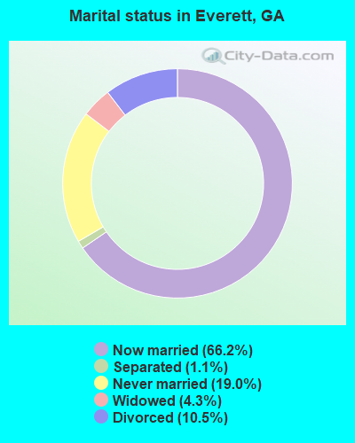
- Never married: 19.0%
- Now married: 66.2%
- Separated: 1.1%
- Widowed: 4.3%
- Divorced: 10.5%
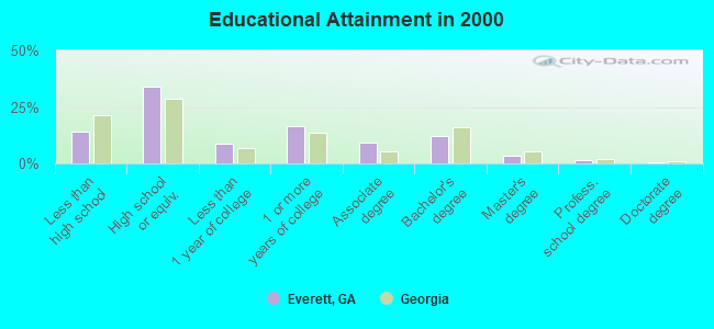
For population 25 years and over in Everett:
- High school or higher: 85.9%
- Bachelor's degree or higher: 17.5%
- Graduate or professional degree: 5.3%
- Unemployed: 6.6%
- Mean travel time to work (commute): 23.3 minutes
| Here: | 9.7 |
| Georgia average: | 13.3 |
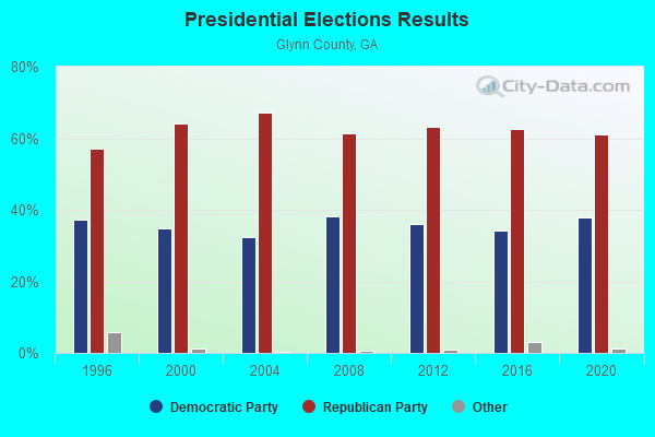

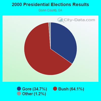
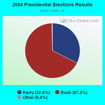
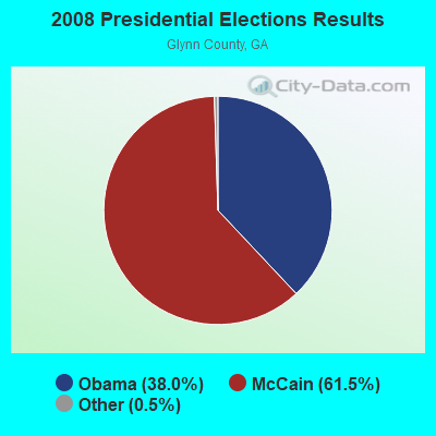

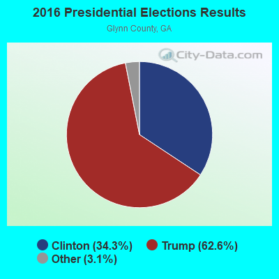
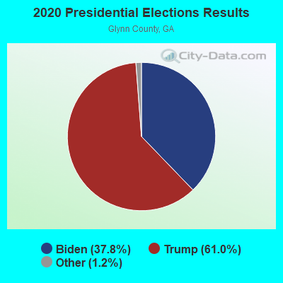
Graphs represent county-level data. Detailed 2008 Election Results
Religion statistics for Everett, GA (based on Glynn County data)
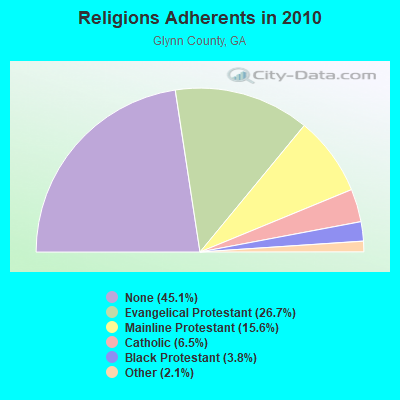
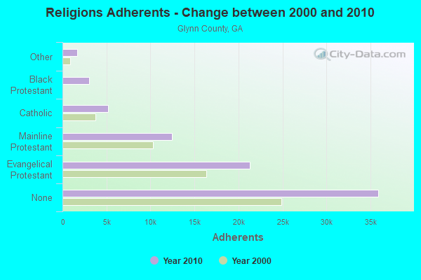
| Religion | Adherents | Congregations |
|---|---|---|
| Evangelical Protestant | 21,274 | 69 |
| Mainline Protestant | 12,459 | 31 |
| Catholic | 5,210 | 4 |
| Black Protestant | 3,022 | 13 |
| Other | 1,707 | 8 |
| Orthodox | 40 | 1 |
| None | 35,914 | - |
Food Environment Statistics:
| This county: | 3.08 / 10,000 pop. |
| Georgia: | 1.91 / 10,000 pop. |
| Glynn County: | 0.13 / 10,000 pop. |
| Georgia: | 0.15 / 10,000 pop. |
| Glynn County: | 0.94 / 10,000 pop. |
| Georgia: | 0.86 / 10,000 pop. |
| Glynn County: | 6.03 / 10,000 pop. |
| Georgia: | 5.12 / 10,000 pop. |
| This county: | 12.99 / 10,000 pop. |
| Georgia: | 7.41 / 10,000 pop. |
| Here: | 12.2% |
| Georgia: | 10.4% |
| Here: | 29.1% |
| Georgia: | 27.8% |
| Here: | 13.5% |
| State: | 14.6% |
8.52% of this county's 2021 resident taxpayers lived in other counties in 2020 ($121,402 average adjusted gross income)
| Here: | 8.52% |
| Georgia average: | 10.21% |
0.07% of residents moved from foreign countries ($672 average AGI)
Glynn County: 0.07% Georgia average: 0.04%
Top counties from which taxpayers relocated into this county between 2020 and 2021:
| from McIntosh County, GA | |
| from Camden County, GA | |
| from Fulton County, GA |
Strongest AM radio stations in Everett:
- WGIG (1440 AM; 5 kW; BRUNSWICK, GA)
- WSFN (790 AM; 2 kW; BRUNSWICK, GA)
- WCGA (1100 AM; daytime; 10 kW; WOODBINE, GA; Owner: COX BROADCAST GROUP, INC.)
- WOKV (690 AM; 50 kW; JACKSONVILLE, FL; Owner: COX RADIO, INC.)
- WOBS (1530 AM; daytime; 50 kW; JACKSONVILLE, FL; Owner: WORD BROADCASTING NETWORK, INC.)
- WMOG (1490 AM; 1 kW; BRUNSWICK, GA; Owner: QANTUM OF BRUNSWICK LICENSE COMPANY, LLC)
- WGSR (1570 AM; 50 kW; FERNANDINA BEACH, FL; Owner: RJM COMMUNICATIONS, INC)
- WFVR (910 AM; 50 kW; VALDOSTA, GA; Owner: RAMA COMMUNICATIONS, INC.)
- WLOP (1370 AM; 5 kW; JESUP, GA; Owner: JESUP BROADCASTING CORP.)
- WIOJ (1010 AM; 10 kW; JACKSONVILLE BEACH, FL)
- WFLF (540 AM; 50 kW; PINE HILLS, FL; Owner: CLEAR CHANNEL BROADCASTING LICENSES, INC.)
- WBMQ (630 AM; 5 kW; SAVANNAH, GA; Owner: CUMULUS LICENSING CORP.)
- WMAC (940 AM; 50 kW; MACON, GA; Owner: CUMULUS LICENSING CORP.)
Strongest FM radio stations in Everett:
- WXMK (105.9 FM; DOCK JUNCTION, GA; Owner: GOLDEN ISLES BROADCASTING, LLC)
- WRJY (104.1 FM; BRUNSWICK, GA; Owner: GOLDEN ISLES BROADCASTING, LLC)
- WAYR-FM (90.7 FM; BRUNSWICK, GA; Owner: GOOD TIDINGS TRUST, INC)
- WBGA (107.7 FM; DARIEN, GA; Owner: QANTUM OF BRUNSWICK LICENSE COMPANY, LLC)
- WHFX (92.7 FM; ST. SIMONS ISLAND, GA; Owner: QANTUM OF BRUNSWICK LICENSE COMPANY, LLC)
- W220DH (91.9 FM; BRUNSWICK, GA; Owner: CALVARY CHAPEL OF TWIN FALLS, INC.)
- WWSN (103.3 FM; WAYCROSS, GA; Owner: QANTUM OF BRUNSWICK LICENSE COMPANY, LLC)
- WWIO-FM (88.9 FM; BRUNSWICK, GA; Owner: GEORGIA PUBLIC TELECOMMUNICATIONS COMMISSION)
- WSOL-FM (101.5 FM; BRUNSWICK, GA; Owner: CITICASTERS LICENSES, L.P.)
- WWRR (100.7 FM; BRUNSWICK, GA; Owner: RENDA BROADCASTING CORP. OF NEVADA)
- WGCO (98.3 FM; MIDWAY, GA; Owner: MONTEREY LICENSES, LLC)
- WYNR (102.5 FM; WAYCROSS, GA; Owner: QANTUM OF BRUNSWICK LICENSE COMPANY, LLC)
- WLPT (88.3 FM; JESUP, GA; Owner: AUGUSTA RADIO FELLOWSHIP INSTITUTE, INC.)
- WECC-FM (89.3 FM; FOLKSTON, GA; Owner: LIGHTHOUSE CHRISTIAN BROADCASTING CORP.)
- WSKX (92.3 FM; HINESVILLE, GA; Owner: COMMUNICATIONS CAPITAL COMPANY II OF GEORGIA, LLC)
- W229AF (90.5 FM; BRUNSWICK, GA; Owner: FAMILY STATIONS, INC.)
TV broadcast stations around Everett:
- WPXC-TV (Channel 21; BRUNSWICK, GA; Owner: PAXSON JAX LICENSE, INC.)
- W33AL (Channel 33; BRUNSWICK, GA; Owner: TRINITY BROADCASTING NETWORK)
- WTGS (Channel 28; HARDEEVILLE, SC; Owner: BLUENOSE BROADCASTING OF SAVANNAH LLC)
FCC Registered Antenna Towers:
21 (See the full list of FCC Registered Antenna Towers in Everett)FCC Registered Microwave Towers:
1- EVERETT, 6.0 Miles Sw Of (Lat: 31.344667 Lon: -81.723139), Overall height: 69.5 m, Call Sign: WSL43,
Assigned Frequencies: 5945.20 MHz, 5974.80 MHz, 6004.50 MHz, 6034.20 MHz, 6123.10 MHz, 6152.80 MHz, Grant Date: 02/15/2000, Expiration Date: 02/01/2010, Cancellation Date: 04/23/2002, Registrant: At&t Corp, 1200 Peachtree Street, Ll 007-1, Atlanta, GA 30309, Phone: (404) 810-4020, Fax: (404) 810-7349, Email:
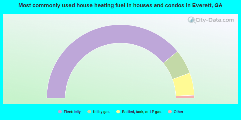
- 78.1%Electricity
- 10.8%Utility gas
- 9.9%Bottled, tank, or LP gas
- 0.9%Wood
- 0.2%Fuel oil, kerosene, etc.
- 0.2%Solar energy
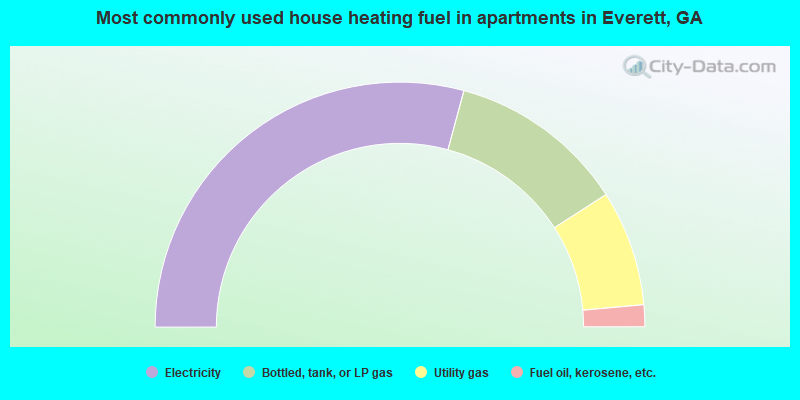
- 58.5%Electricity
- 23.4%Bottled, tank, or LP gas
- 15.3%Utility gas
- 2.9%Fuel oil, kerosene, etc.
Everett compared to Georgia state average:
- Unemployed percentage below state average.
- Black race population percentage below state average.
- Hispanic race population percentage significantly below state average.
- Median age below state average.
- Foreign-born population percentage significantly below state average.
- Length of stay since moving in significantly above state average.
- Number of rooms per house significantly below state average.
- House age significantly below state average.
Everett on our top lists:
- #6 on the list of "Top 101 cities with largest percentage of males in occupations: other teachers and instructors, education, training, and library occupations (population 5,000+)"
- #13 on the list of "Top 101 cities with largest percentage of females in occupations: construction trades workers except carpenters, electricians, painters, plumbers, and construction laborers (population 5,000+)"
- #22 on the list of "Top 101 cities with the largest percentage of people in other group homes (population 1,000+)"
- #40 on the list of "Top 101 cities with largest percentage of males in occupations: communications equipment operators (population 5,000+)"
- #54 on the list of "Top 101 cities with largest percentage of females in occupations: other protective service workers including supervisors (population 5,000+)"
- #54 on the list of "Top 101 cities with largest percentage of males in industries: paper (population 5,000+)"
- #65 on the list of "Top 101 cities with largest percentage of males in occupations: supervisors and other personal care and service workers except personal appearance, transportation, and child care workers (population 5,000+)"
- #69 on the list of "Top 101 cities with largest percentage of females in occupations: food processing workers (population 5,000+)"
- #75 on the list of "Top 101 cities with largest percentage of males in industries: department and other general merchandise stores (population 5,000+)"
- #93 on the list of "Top 101 cities with the largest percentage of people in hospices or homes for chronically ill (population 1,000+)"
- #94 on the list of "Top 101 cities with largest percentage of males in industries: wood products (population 5,000+)"
- #81 on the list of "Top 101 counties with the highest Sulfur Oxides Annual air pollution readings in 2012 (µg/m3)"