Flaherty, Kentucky
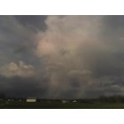
Flaherty: I toke this with my phone as we stopped to get the mail this field is rite on the other side of my drive way. It was a stormy day and the winds were rough . We thought it looked like the wind was rolling the clouds in this tornado like shape.And if you look ready hard there are this colors of blue and pink in the clouds.There is just so much to this picture.
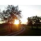
Flaherty: this is a picture that was taken by me in my drive way when the sun was going down.. i though it was very pretty
- add
your
Submit your own pictures of this place and show them to the world
- OSM Map
- General Map
- Google Map
- MSN Map

| Males: 6,201 | |
| Females: 6,001 |
| Median resident age: | 28.6 years |
| Kentucky median age: | 35.9 years |
Zip code: 40108
| Flaherty: | $65,525 |
| KY: | $59,341 |
Estimated per capita income in 2022: $31,790 (it was $14,424 in 2000)
Flaherty CCD income, earnings, and wages data
Estimated median house or condo value in 2022: $208,660 (it was $75,800 in 2000)
| Flaherty: | $208,660 |
| KY: | $196,300 |
Detailed information about poverty and poor residents in Flaherty, KY


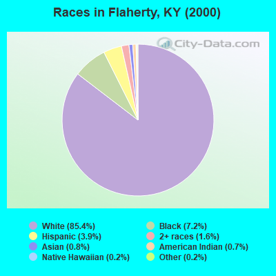
- 10,15885.4%White alone
- 8547.2%Black alone
- 4653.9%Hispanic
- 1891.6%Two or more races
- 1010.8%Asian alone
- 800.7%American Indian alone
- 270.2%Native Hawaiian and Other
Pacific Islander alone - 220.2%Other race alone
Races in Flaherty detailed stats: ancestries, foreign born residents, place of birth
 Recent articles from our blog. Our writers, many of them Ph.D. graduates or candidates, create easy-to-read articles on a wide variety of topics.
Current Local Time: EST time zone
Elevation: 793 feet
Land area: 96.5 square miles.
Population density: 126 people per square mile (very low).

| Flaherty CCD: | 0.7% ($546) |
| Kentucky: | 0.8% ($610) |
Nearest city with pop. 50,000+: Louisville, KY  (27.5 miles , pop. 256,231).
Nearest city with pop. 1,000,000+: Chicago, IL (286.4 miles , pop. 2,896,016).
Nearest cities:
), ), ), ), Latitude: 37.90 N, Longitude: 86.03 W

| Here: | 4.1% |
| Kentucky: | 3.8% |
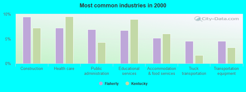
- Construction (9.5%)
- Health care (7.2%)
- Public administration (6.9%)
- Educational services (6.7%)
- Accommodation & food services (5.2%)
- Truck transportation (4.5%)
- Transportation equipment (4.5%)
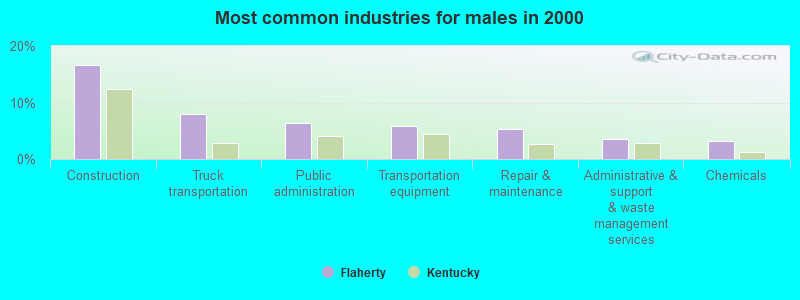
- Construction (16.7%)
- Truck transportation (8.0%)
- Public administration (6.3%)
- Transportation equipment (5.8%)
- Repair & maintenance (5.3%)
- Administrative & support & waste management services (3.6%)
- Chemicals (3.2%)
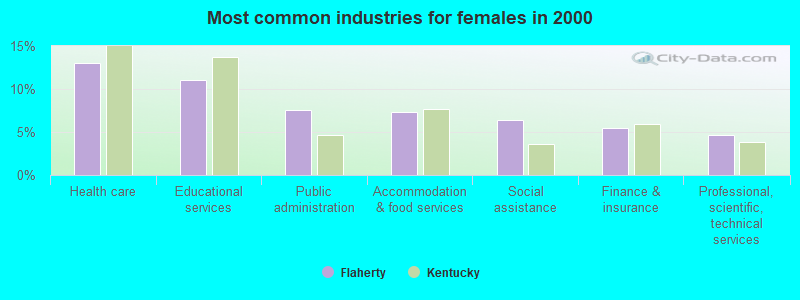
- Health care (13.1%)
- Educational services (11.1%)
- Public administration (7.6%)
- Accommodation & food services (7.3%)
- Social assistance (6.4%)
- Finance & insurance (5.5%)
- Professional, scientific, technical services (4.6%)
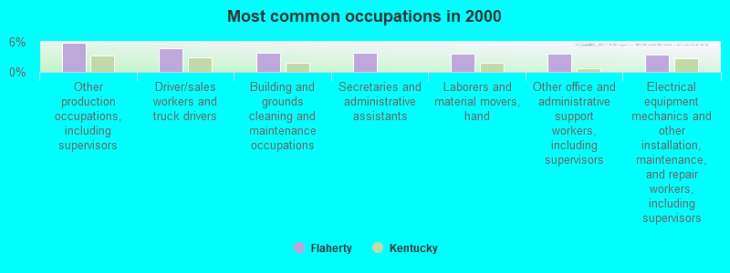
- Other production occupations, including supervisors (5.8%)
- Driver/sales workers and truck drivers (4.8%)
- Building and grounds cleaning and maintenance occupations (3.8%)
- Secretaries and administrative assistants (3.8%)
- Laborers and material movers, hand (3.7%)
- Other office and administrative support workers, including supervisors (3.7%)
- Electrical equipment mechanics and other installation, maintenance, and repair workers, including supervisors (3.4%)
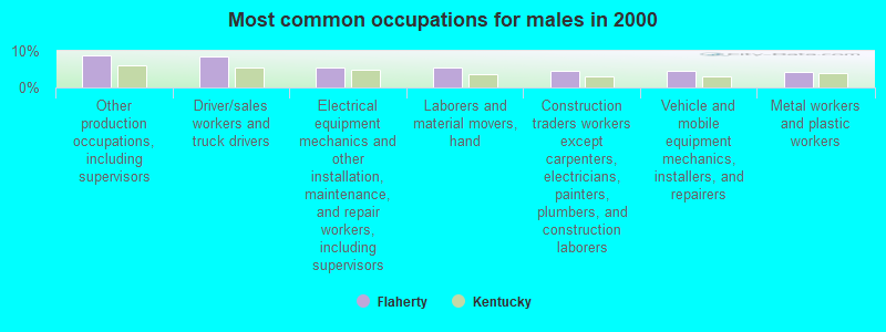
- Other production occupations, including supervisors (8.8%)
- Driver/sales workers and truck drivers (8.5%)
- Electrical equipment mechanics and other installation, maintenance, and repair workers, including supervisors (5.6%)
- Laborers and material movers, hand (5.6%)
- Construction traders workers except carpenters, electricians, painters, plumbers, and construction laborers (4.5%)
- Vehicle and mobile equipment mechanics, installers, and repairers (4.5%)
- Metal workers and plastic workers (4.4%)
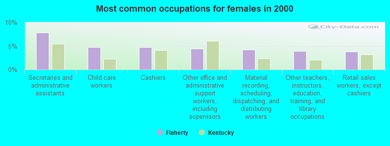
- Secretaries and administrative assistants (7.8%)
- Child care workers (4.7%)
- Cashiers (4.7%)
- Other office and administrative support workers, including supervisors (4.4%)
- Material recording, scheduling, dispatching, and distributing workers (4.2%)
- Other teachers, instructors, education, training, and library occupations (3.9%)
- Retail sales workers, except cashiers (3.8%)
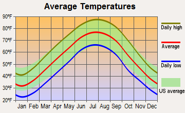
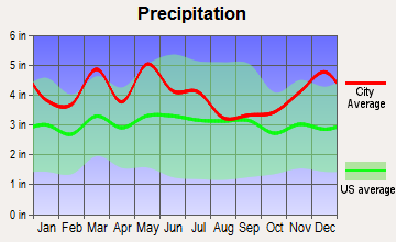
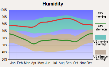
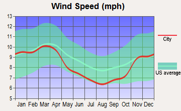
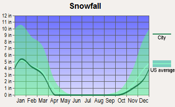
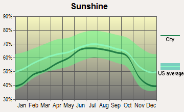
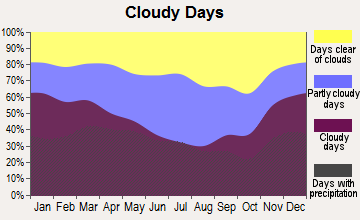
Average climate in Flaherty, Kentucky
Based on data reported by over 4,000 weather stations
(lower is better)
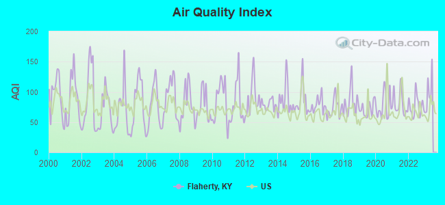
Air Quality Index (AQI) level in 2022 was 76.5. This is about average.
| City: | 76.5 |
| U.S.: | 72.6 |
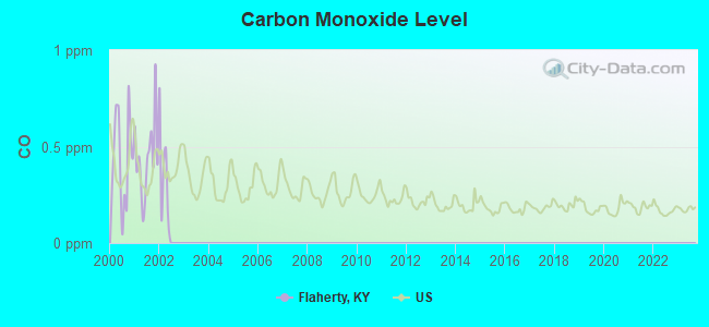
Carbon Monoxide (CO) [ppm] level in 2001 was 0.440. This is significantly worse than average. Closest monitor was 13.3 miles away from the city center.
| City: | 0.440 |
| U.S.: | 0.251 |
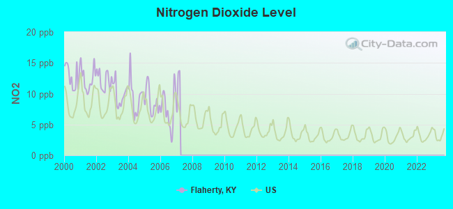
Nitrogen Dioxide (NO2) [ppb] level in 2006 was 7.50. This is significantly worse than average. Closest monitor was 13.3 miles away from the city center.
| City: | 7.50 |
| U.S.: | 5.11 |
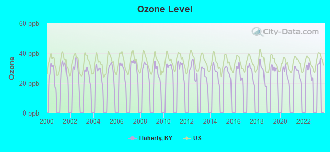
Ozone [ppb] level in 2022 was 28.2. This is about average. Closest monitor was 13.3 miles away from the city center.
| City: | 28.2 |
| U.S.: | 33.3 |
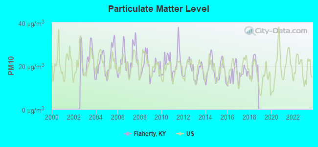
Particulate Matter (PM10) [µg/m3] level in 2018 was 19.3. This is about average. Closest monitor was 13.3 miles away from the city center.
| City: | 19.3 |
| U.S.: | 19.2 |
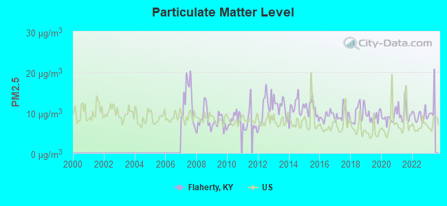
Particulate Matter (PM2.5) [µg/m3] level in 2022 was 9.13. This is about average. Closest monitor was 13.3 miles away from the city center.
| City: | 9.13 |
| U.S.: | 8.11 |
Tornado activity:
Flaherty-area historical tornado activity is slightly above Kentucky state average. It is 57% greater than the overall U.S. average.
On 4/3/1974, a category F5 (max. wind speeds 261-318 mph) tornado 11.2 miles away from the Flaherty place center killed 31 people and injured 270 people and caused between $500,000 and $5,000,000 in damages.
On 4/3/1974, a category F4 (max. wind speeds 207-260 mph) tornado 14.2 miles away from the place center killed 3 people and injured 81 people and caused between $50,000 and $500,000 in damages.
Earthquake activity:
Flaherty-area historical earthquake activity is significantly above Kentucky state average. It is 133% greater than the overall U.S. average.On 4/18/2008 at 09:36:59, a magnitude 5.4 (5.1 MB, 4.8 MS, 5.4 MW, 5.2 MW, Class: Moderate, Intensity: VI - VII) earthquake occurred 107.9 miles away from Flaherty center
On 4/18/2008 at 09:36:59, a magnitude 5.2 (5.2 MW, Depth: 8.9 mi) earthquake occurred 107.9 miles away from the city center
On 7/27/1980 at 18:52:21, a magnitude 5.2 (5.1 MB, 4.7 MS, 5.0 UK, 5.2 UK) earthquake occurred 115.6 miles away from Flaherty center
On 6/18/2002 at 17:37:15, a magnitude 5.0 (4.3 MB, 4.6 MW, 5.0 LG) earthquake occurred 95.7 miles away from the city center
On 6/10/1987 at 23:48:54, a magnitude 5.1 (4.9 MB, 4.4 MS, 4.6 MS, 5.1 LG) earthquake occurred 119.1 miles away from Flaherty center
On 4/18/2008 at 15:14:16, a magnitude 4.8 (4.5 MB, 4.8 MW, 4.6 MW, Class: Light, Intensity: IV - V) earthquake occurred 106.6 miles away from Flaherty center
Magnitude types: regional Lg-wave magnitude (LG), body-wave magnitude (MB), surface-wave magnitude (MS), moment magnitude (MW)
Natural disasters:
The number of natural disasters in Meade County (15) is near the US average (15).Major Disasters (Presidential) Declared: 12
Emergencies Declared: 2
Causes of natural disasters: Storms: 8, Floods: 7, Tornadoes: 6, Winter Storms: 3, Winds: 2, Blizzard: 1, Hurricane: 1, Tropical Depression: 1, Other: 1 (Note: some incidents may be assigned to more than one category).
Hospitals and medical centers near Flaherty:
- DAVITA - RADCLIFF DIALYSIS (Dialysis Facility, about 7 miles away; RADCLIFF, KY)
- NORTH HARDIN HEALTH AND REHABILITATION CENTER (Nursing Home, about 8 miles away; RADCLIFF, KY)
- LINCOLN TRAIL BEHAVIORAL HEALTH SYSTEM (Hospital, about 10 miles away; RADCLIFF, KY)
- MEDCO CENTER OF BRANDENBURG (Nursing Home, about 11 miles away; BRANDENBURG, KY)
- FMC - OF HARDIN COUNTY (Dialysis Facility, about 15 miles away; ELIZABETHTOWN, KY)
- SURGICAL CENTER OF ELIZABETHTOWN (Hospital, about 16 miles away; ELIZABETHTOWN, KY)
- KINDRED NURSING AND REHABILITATION-WOODLAND (Nursing Home, about 16 miles away; ELIZABETHTOWN, KY)
Colleges/universities with over 2000 students nearest to Flaherty:
- Elizabethtown Community and Technical College (about 17 miles; Elizabethtown, KY; Full-time enrollment: 3,762)
- University of Louisville (about 27 miles; Louisville, KY; FT enrollment: 16,640)
- Bellarmine University (about 29 miles; Louisville, KY; FT enrollment: 3,180)
- Jefferson Community and Technical College (about 29 miles; Louisville, KY; FT enrollment: 7,950)
- Sullivan University (about 30 miles; Louisville, KY; FT enrollment: 5,129)
- The Southern Baptist Theological Seminary (about 31 miles; Louisville, KY; FT enrollment: 2,360)
- Indiana University-Southeast (about 33 miles; New Albany, IN; FT enrollment: 5,050)
Points of interest:
Notable locations in Flaherty: Tip Top (A), Muldraugh Fire Department (B), Flaherty Fire and Rescue Department Station 2 (C), Flaherty Volunteer Fire Department Station 1 (D). Display/hide their locations on the map
Churches in Flaherty include: Hilltop Church (A), Zion Grove Church (B), Guston Church (C), Buck Grove Church (D). Display/hide their locations on the map
Cemeteries: Weather Cemetery (1), Bunger Cemetery (2), Hynes Cemetery (3), Swan Cemetery (4), Garnettsville Cemetery (5), Withers Cemetery (6). Display/hide their locations on the map
Reservoirs: Tobacco Leaf Lake (A), Dickerson Lake (B). Display/hide their locations on the map
Streams, rivers, and creeks: Abrahams Run (A), Gander Branch (B). Display/hide their locations on the map
| This place: | 2.8 people |
| Kentucky: | 2.5 people |
| This place: | 77.5% |
| Whole state: | 66.9% |
| This place: | 5.9% |
| Whole state: | 6.4% |
Likely homosexual households (counted as self-reported same-sex unmarried-partner households)
- Lesbian couples: 0.2% of all households
- Gay men: 0.2% of all households
| This place: | 11.0% |
| Whole state: | 15.8% |
| This place: | 5.7% |
| Whole state: | 6.6% |
For population 15 years and over in Flaherty:
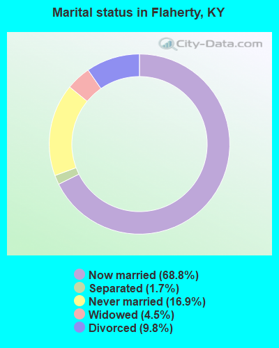
- Never married: 16.9%
- Now married: 68.8%
- Separated: 1.7%
- Widowed: 4.5%
- Divorced: 9.8%
For population 25 years and over in Flaherty:
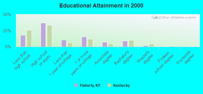
- High school or higher: 81.9%
- Bachelor's degree or higher: 11.5%
- Graduate or professional degree: 2.5%
- Unemployed: 10.5%
- Mean travel time to work (commute): 27.0 minutes
| Here: | 9.5 |
| Kentucky average: | 13.8 |
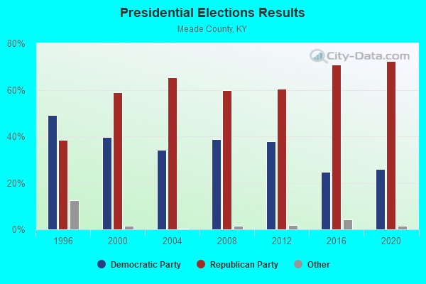
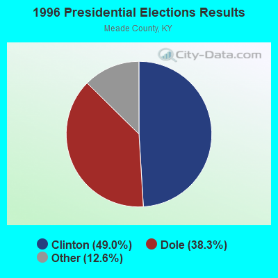
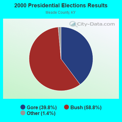
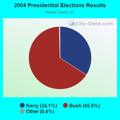
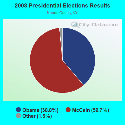
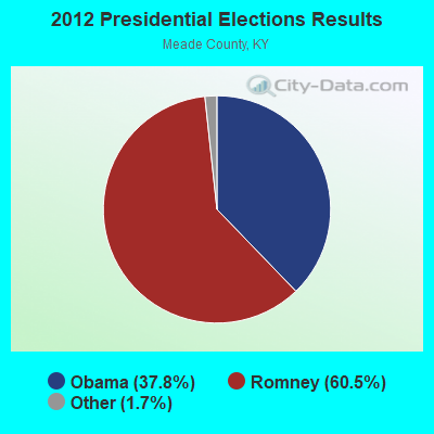
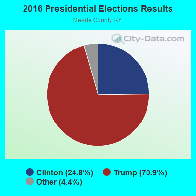
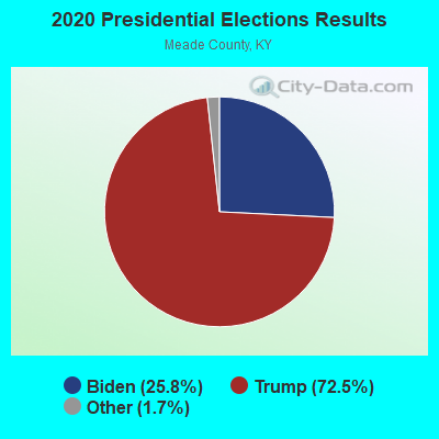
Graphs represent county-level data. Detailed 2008 Election Results
Religion statistics for Flaherty, KY (based on Meade County data)
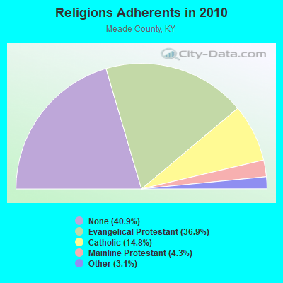
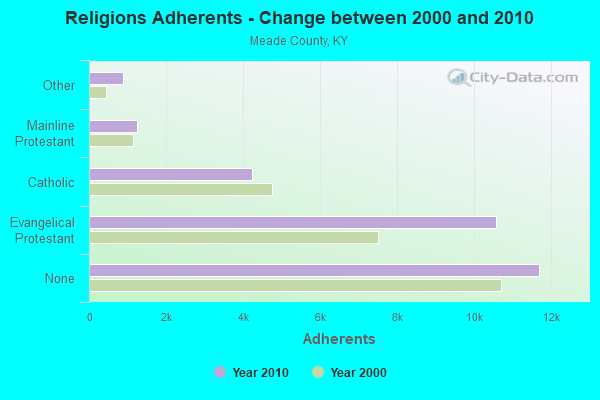
| Religion | Adherents | Congregations |
|---|---|---|
| Evangelical Protestant | 10,566 | 29 |
| Catholic | 4,227 | 4 |
| Mainline Protestant | 1,244 | 5 |
| Other | 877 | 1 |
| None | 11,688 | - |
Food Environment Statistics:
| Meade County: | 1.10 / 10,000 pop. |
| Kentucky: | 2.19 / 10,000 pop. |
| Meade County: | 0.37 / 10,000 pop. |
| Kentucky: | 0.74 / 10,000 pop. |
| Meade County: | 5.51 / 10,000 pop. |
| State: | 4.36 / 10,000 pop. |
| Meade County: | 2.57 / 10,000 pop. |
| Kentucky: | 5.74 / 10,000 pop. |
| Meade County: | 11.1% |
| Kentucky: | 11.0% |
| Meade County: | 33.0% |
| Kentucky: | 30.0% |
| This county: | 13.5% |
| Kentucky: | 15.9% |
10.89% of this county's 2021 resident taxpayers lived in other counties in 2020 ($55,543 average adjusted gross income)
| Here: | 10.89% |
| Kentucky average: | 7.04% |
0.34% of residents moved from foreign countries ($2,243 average AGI)
Meade County: 0.34% Kentucky average: 0.02%
Top counties from which taxpayers relocated into this county between 2020 and 2021:
| from Hardin County, KY | |
| from Jefferson County, KY | |
| from Breckinridge County, KY |
10.44% of this county's 2020 resident taxpayers moved to other counties in 2021 ($52,951 average adjusted gross income)
| Here: | 10.44% |
| Kentucky average: | 6.89% |
0.22% of residents moved to foreign countries ($1,551 average AGI)
Meade County: 0.22% Kentucky average: 0.01%
Top counties to which taxpayers relocated from this county between 2020 and 2021:
| to Hardin County, KY | |
| to Jefferson County, KY | |
| to Breckinridge County, KY |
Strongest AM radio stations in Flaherty:
- WHAS (840 AM; 50 kW; LOUISVILLE, KY; Owner: CLEAR CHANNEL BROADCASTING LICENSES, INC.)
- WKJK (1080 AM; 10 kW; LOUISVILLE, KY; Owner: CLEAR CHANNEL BROADCASTING LICENSES, INC.)
- WXXA (790 AM; 5 kW; LOUISVILLE, KY)
- WGTK (970 AM; 5 kW; LOUISVILLE, KY; Owner: SALEM MEDIA OF KENTUCKY, INC.)
- WSM (650 AM; 50 kW; NASHVILLE, TN; Owner: GAYLORD ENTERTAINMENT COMPANY)
- WLW (700 AM; 50 kW; CINCINNATI, OH; Owner: JACOR BROADCASTING CORPORATION)
- WLCR (1470 AM; daytime; 2 kW; SHEPHERDSVILLE, KY; Owner: LCR PARTNERS, L.P.)
- WAMB (1160 AM; 50 kW; DONELSON, TN; Owner: GREAT SOUTHERN BROADCASTING COMPANY, INC.)
- WSAI (1530 AM; 50 kW; CINCINNATI, OH; Owner: JACOR BROADCASTING CORPORATION)
- WKDA (1200 AM; 50 kW; NASHVILLE, TN; Owner: RADIO NASHVILLE, INC.)
- WMMG (1140 AM; daytime; 0 kW; BRANDENBURG, KY; Owner: MEADE COUNTY COMMUNICATIONS, INC.)
- WDRD (680 AM; 1 kW; NEWBURG, KY; Owner: ABC, INC.)
- WLOU (1350 AM; 2 kW; LOUISVILLE, KY; Owner: MORTENSON BROADCASTING CO., INC.)
Strongest FM radio stations in Flaherty:
- WASE (103.5 FM; RADCLIFF, KY; Owner: W & B BROADCASTING, INC.)
- WKUE (90.9 FM; ELIZABETHTOWN, KY; Owner: WESTERN KENTUCKY UNIVERSITY)
- WLVK (105.5 FM; FORT KNOX, KY; Owner: BIG CAT BROADCASTING, INC.)
- WQXE (98.3 FM; ELIZABETHTOWN, KY; Owner: SKYTOWER COMMUNICATIONS-E'TOWN, INC.)
- WRVI (105.9 FM; VALLEY STATION, KY; Owner: SALEM MEDIA OF KENTUCKY, INC.)
- WMMG-FM (93.5 FM; BRANDENBURG, KY; Owner: MEADE COUNTY COMMUNICATIONS, INC.)
- WULF (94.3 FM; HARDINSBURG, KY; Owner: SKYTOWER COMMUNICATIONS - 94.3, LLC)
- WJIE-FM (88.5 FM; OKOLONA, KY; Owner: EVANGEL SCHOOLS, INC.)
- WQMF (95.7 FM; JEFFERSONVILLE, IN; Owner: CLEAR CHANNEL BROADCASTING LICENSES, INC.)
- WAMZ (97.5 FM; LOUISVILLE, KY; Owner: CLEAR CHANNEL BROADCASTING LICENSES, INC.)
- WRZI (101.5 FM; VINE GROVE, KY; Owner: ELIZABETHTOWN CBC, INC.)
- WSFR (107.7 FM; CORYDON, IN; Owner: CXR HOLDINGS, INC.)
- WLRS (105.1 FM; SHEPHERDSVILLE, KY; Owner: BLUE CHIP BROADCASTING LICENSES II, LTD.)
- WFPL (89.3 FM; LOUISVILLE, KY; Owner: KENTUCKY PUBLIC RADIO, INC.)
- WTHX (107.3 FM; LEBANON JUNCTION, KY; Owner: ELIZABETHTOWN CBC, INC.)
- WFPK (91.9 FM; LOUISVILLE, KY; Owner: KENTUCKY PUBLIC RADIO, INC.)
- WUOL-FM (90.5 FM; LOUISVILLE, KY; Owner: KENTUCKY PUBLIC RADIO, INC.)
- WDJX (99.7 FM; LOUISVILLE, KY; Owner: BLUE CHIP BROADCASTING LICENSES II, LTD.)
- WKMO (106.3 FM; HODGENVILLE, KY; Owner: ELIZABETHTOWN CBC, INC.)
- W284AD (104.7 FM; NEW ALBANY, IN; Owner: LIFETALK RADIO, INC.)
TV broadcast stations around Flaherty:
- WBKI-CA (Channel 28; LOUISVILLE, KY; Owner: LOUISVILLE COMMUNICATIONS, LLC)
- W24BW (Channel 24; LOUISVILLE, KY; Owner: GREATER LOUISVILLE COMMUNICATIONS)
- WKZT-TV (Channel 23; ELIZABETHTOWN, KY; Owner: KENTUCKY AUTHORITY FOR EDUCATIONAL TV)
- WAVE (Channel 3; LOUISVILLE, KY; Owner: LIBCO, INC.)
- WHAS-TV (Channel 11; LOUISVILLE, KY; Owner: BELO KENTUCKY, INC.)
- W39CJ (Channel 39; ELIZABETHTOWN, KY; Owner: TRINITY BROADCASTING NETWORK)
- WDRB (Channel 41; LOUISVILLE, KY; Owner: INDEPENDENCE TELEVISION COMPANY)
- WFTE (Channel 58; SALEM, IN; Owner: INDEPENDENCE TELEVISION COMPANY)
- WLKY-TV (Channel 32; LOUISVILLE, KY; Owner: WLKY HEARST-ARGYLE TELEVISION, INC.)
- WVHF-LP (Channel 5; JEFFERSONVILLE, ETC., IN; Owner: JOHN W. SMITH, JR.)
- WBKI-TV (Channel 34; CAMPBELLSVILLE, KY; Owner: LOUISVILLE COMMUNICATIONS, LLC)
- WJYL-CA (Channel 45; CLARKSVILLE, IN; Owner: JOHN W. SMITH, JR.)
- WBXV-CA (Channel 13; LOUISVILLE, KY; Owner: THE BOX WORLDWIDE LLC)
FCC Registered Microwave Towers:
1- 1 Mi Nw Of (Lat: 37.853944 Lon: -86.101611), Overall height: 76.2 m, Call Sign: WMW847,
Assigned Frequencies: 946.000 MHz, Grant Date: 09/15/1995, Expiration Date: 08/01/2012, Cancellation Date: 09/11/2007, Registrant: Skytower Communications 94.3, LLC, 233 West Dixie, Elizabethtown, KY 42701, Phone: (270) 765-0943, Fax: (270) 737-7229, Email:
FCC Registered Amateur Radio Licenses:
1- Call Sign: KK4NHZ, Licensee ID: L01753661, Grant Date: 11/29/2022, Expiration Date: 12/17/2032, Certifier: David M Reese, Registrant: David M Reese, 1080 Sunset Dr, Flaherty, KY 40175
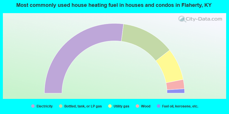
- 54.2%Electricity
- 24.7%Bottled, tank, or LP gas
- 14.9%Utility gas
- 4.3%Wood
- 2.0%Fuel oil, kerosene, etc.
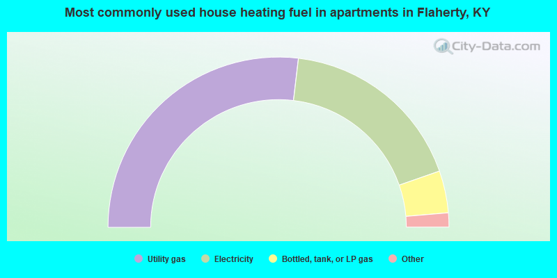
- 53.7%Utility gas
- 35.5%Electricity
- 8.0%Bottled, tank, or LP gas
- 1.4%Wood
- 0.9%Fuel oil, kerosene, etc.
- 0.2%Other fuel
- 0.2%No fuel used
Flaherty compared to Kentucky state average:
- Median age significantly below state average.
- Foreign-born population percentage significantly below state average.
- Length of stay since moving in significantly above state average.
- Number of rooms per house significantly below state average.
- House age significantly below state average.
- Percentage of population with a bachelor's degree or higher below state average.
Flaherty on our top lists:
- #10 on the list of "Top 101 cities with largest percentage of females in industries: gasoline stations (population 5,000+)"
- #10 on the list of "Top 101 cities with largest percentage of males in industries: truck transportation (population 5,000+)"
- #14 on the list of "Top 101 cities with largest percentage of males in occupations: pipelayers, plumbers, pipefitters, and steamfitters (population 5,000+)"
- #22 on the list of "Top 101 cities with largest percentage of females in industries: other transportation, and support activities, and couriers (population 5,000+)"
- #37 on the list of "Top 101 cities with largest percentage of females in occupations: child care workers (population 5,000+)"
- #37 on the list of "Top 101 cities with largest percentage of males in occupations: laborers and material movers, hand (population 5,000+)"
- #38 on the list of "Top 101 cities with largest percentage of females in occupations: printing workers (population 5,000+)"
- #60 on the list of "Top 101 cities with largest percentage of females in industries: printing and related support activities (population 5,000+)"
- #63 on the list of "Top 101 cities with largest percentage of males in industries: leather and allied products (population 5,000+)"
- #64 on the list of "Top 101 cities with largest percentage of males in occupations: assemblers and fabricators (population 5,000+)"
- #66 on the list of "Top 101 cities with largest percentage of males in occupations: librarians, curators, and archivists (population 5,000+)"
- #67 on the list of "Top 101 cities with largest percentage of males in industries: repair and maintenance (population 5,000+)"
- #69 on the list of "Top 101 cities with largest percentage of females in industries: transportation equipment (population 5,000+)"
- #74 on the list of "Top 101 cities with largest percentage of females in industries: social assistance (population 5,000+)"
- #76 on the list of "Top 101 cities with largest percentage of males in industries: vending machine operators (population 5,000+)"
- #79 on the list of "Top 101 cities with largest percentage of males in industries: warehousing and storage (population 5,000+)"
- #86 on the list of "Top 101 cities with largest percentage of males in industries: water transportation (population 5,000+)"
- #97 on the list of "Top 101 cities with largest percentage of males in industries: drugs, sundries, and chemical and allied products merchant wholesalers (population 5,000+)"
- #100 on the list of "Top 101 cities with largest percentage of females in industries: petroleum and petroleum products merchant wholesalers (population 5,000+)"
- #72 on the list of "Top 101 counties with the highest percentage of residents relocating from other counties between 2010 and 2011"
- #81 on the list of "Top 101 counties with the lowest surface withdrawal of fresh water for public supply"
- #85 on the list of "Top 101 counties with the highest percentage of residents relocating to foreign countries in 2011"
- #86 on the list of "Top 101 counties with the highest percentage of residents relocating from foreign countries between 2010 and 2011"