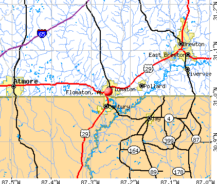
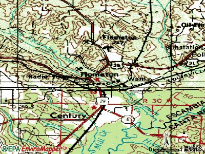
Flomaton, Alabama
Submit your own pictures of this town and show them to the world
- OSM Map
- General Map
- Google Map
- MSN Map
Population change since 2000: -8.2%
 |
| Males: 618 | |
| Females: 840 |
| Median resident age: | 32.8 years |
| Alabama median age: | 39.6 years |
Zip codes: 36441.
| Flomaton: | $37,541 |
| AL: | $59,674 |
Estimated per capita income in 2022: $21,863 (it was $14,360 in 2000)
Flomaton town income, earnings, and wages data
Estimated median house or condo value in 2022: $116,800 (it was $53,900 in 2000)
| Flomaton: | $116,800 |
| AL: | $200,900 |
Mean prices in 2022: all housing units: $128,185; detached houses: $144,657; mobile homes: $68,887
Median gross rent in 2022: $676.
(14.5% for White Non-Hispanic residents, 60.4% for Black residents, 32.1% for two or more races residents)
Detailed information about poverty and poor residents in Flomaton, AL


Compare current foreclosures near Flomaton, AL:
| Photo | Address | Area | Beds / Baths | Price | Details |
|---|---|---|---|---|---|

|
#1
College St
Flomaton, AL 36441
|
- sq. feet
|
2 baths 3 beds |
show details | |

|
#2
Pecan Leaf Ln
Flomaton, AL 36441
|
2 sq. feet
|
2 baths 3 beds |
show details | |

|
#3
Glass Dairy Rd
Flomaton, AL 36441
|
1,460 sq. feet
|
1 baths - beds |
show details | |

|
#4
Mcbride Cir
Flomaton, AL 36441
|
1,008 sq. feet
|
1 baths - beds |
show details | |

|
#5
Dixon Rd
Flomaton, AL 36441
|
- sq. feet
|
- baths - beds |
show details | |

|
#6
Elizabeth Ave
Flomaton, AL 36441
|
- sq. feet
|
- baths - beds |
show details | |

|
#7
Fowler Ln
Flomaton, AL 36441
|
1,280 sq. feet
|
- baths - beds |
show details | |

|
#8
Old Atmore Rd Lot 24
Flomaton, AL 36441
|
- sq. feet
|
- baths - beds |
show details | |

|
#9
Old Atmore Rd Lot 22
Flomaton, AL 36441
|
- sq. feet
|
- baths - beds |
show details | |

|
#10
Community Church Rd
Flomaton, AL 36441
|
- sq. feet
|
- baths - beds |
show details |
| Photo | Address | Area | Beds / Baths | Price | Details |
|---|---|---|---|---|---|

|
#11
Vanhousen Road
Flomaton, AL 36441
|
- sq. feet
|
- baths - beds |
show details | |

|
#12
Pineview Dr
Brewton, AL 36426
|
1,075 sq. feet
|
1 baths 3 beds |
show details | |

|
#13
4th Ave
Atmore, AL 36502
|
1,200 sq. feet
|
1 baths 4 beds |
show details | |

|
#14
Mcrae St
Atmore, AL 36502
|
3,429 sq. feet
|
2 baths 4 beds |
show details | |

|
#15
Robinsonville Rd
Atmore, AL 36502
|
2,033 sq. feet
|
2 baths 3 beds |
show details | |

|
#16
Forest Ave
Atmore, AL 36502
|
2,614 sq. feet
|
3 baths 3 beds |
show details | |

|
#17
E Ashley St
Atmore, AL 36502
|
750 sq. feet
|
1 baths 3 beds |
show details | |

|
#18
Medical Park Dr
Atmore, AL 36502
|
1,498 sq. feet
|
1 baths 3 beds |
show details | |

|
#19
Mason St
Brewton, AL 36426
|
1,281 sq. feet
|
1 baths 3 beds |
show details | |

|
#20
White St
Brewton, AL 36426
|
1,644 sq. feet
|
2 baths 3 beds |
show details |
| Photo | Address | Area | Beds / Baths | Price | Details |
|---|---|---|---|---|---|

|
#21
Hazel Godwin Rd
Jay, FL 32565
|
1,448 sq. feet
|
2 baths 3 beds |
show details | |

|
#22
Jack Springs Rd
Atmore, AL 36502
|
988 sq. feet
|
1 baths 3 beds |
show details | |

|
#23
S Pensacola Ave
Atmore, AL 36502
|
2,140 sq. feet
|
2 baths 3 beds |
show details | |

|
#24
Highland Ave
Atmore, AL 36502
|
2,136 sq. feet
|
2 baths 3 beds |
show details | |

|
#25
Mcrae St
Atmore, AL 36502
|
1,200 sq. feet
|
2 baths 3 beds |
show details | |

|
#26
Virginia Dr
Brewton, AL 36426
|
1,584 sq. feet
|
2 baths 3 beds |
show details | |

|
#27
Langston Ln
Brewton, AL 36426
|
1,664 sq. feet
|
5 baths 6 beds |
show details | |

|
#28
W Rankin St
Brewton, AL 36426
|
1,282 sq. feet
|
2 baths - beds |
show details | |

|
#29
Crenshaw St
Brewton, AL 36426
|
756 sq. feet
|
1 baths - beds |
show details | |

|
#30
Northgate Dr
Atmore, AL 36502
|
3,380 sq. feet
|
1 baths - beds |
show details |
| Photo | Address | Area | Beds / Baths | Price | Details |
|---|---|---|---|---|---|

|
#31
Sneed Dr
Atmore, AL 36502
|
2,299 sq. feet
|
1 baths - beds |
show details | |

|
#32
Florida St
Brewton, AL 36426
|
1,823 sq. feet
|
2 baths - beds |
show details | |

|
#33
E Ridgeley St
Atmore, AL 36502
|
1,189 sq. feet
|
1 baths - beds |
show details | |

|
#34
Taylor St
Brewton, AL 36426
|
1,696 sq. feet
|
1 baths - beds |
show details | |

|
#35
Earl St
Brewton, AL 36426
|
1,274 sq. feet
|
1 baths - beds |
show details | |

|
#36
Moore St
Brewton, AL 36426
|
1,048 sq. feet
|
2 baths - beds |
show details | |

|
#37
S Main St
Atmore, AL 36502
|
1,363 sq. feet
|
1 baths - beds |
show details | |

|
#38
Shoffner St
Brewton, AL 36426
|
936 sq. feet
|
1 baths - beds |
show details | |

|
#39
Mayo St
Brewton, AL 36426
|
1,234 sq. feet
|
1 baths - beds |
show details | |

|
#40
4th Ave
Atmore, AL 36502
|
1,737 sq. feet
|
1 baths - beds |
show details |
| Photo | Address | Area | Beds / Baths | Price | Details |
|---|---|---|---|---|---|

|
#41
Dogwood Pl
Atmore, AL 36502
|
1,595 sq. feet
|
2 baths - beds |
show details | |

|
#42
W Craig St
Atmore, AL 36502
|
1,392 sq. feet
|
1 baths - beds |
show details | |

|
#43
Saint Nicholas Ave
Brewton, AL 36426
|
1,938 sq. feet
|
1 baths - beds |
show details | |

|
#44
Pecan Dr
Brewton, AL 36426
|
1,822 sq. feet
|
1 baths - beds |
show details | |

|
#45
Lovelace Ave
Brewton, AL 36426
|
1,958 sq. feet
|
1 baths - beds |
show details | |

|
#46
N Pine St
Brewton, AL 36426
|
1,534 sq. feet
|
2 baths - beds |
show details | |

|
#47
W Church St
Atmore, AL 36502
|
1,060 sq. feet
|
1 baths - beds |
show details | |

|
#48
Backwoods Rd
Century, FL 32535
|
1,000 sq. feet
|
2 baths - beds |
show details | |

|
#49
Short St
Atmore, AL 36502
|
1,000 sq. feet
|
1 baths - beds |
show details | |

|
Check over 1 million property listings on Foreclosure.com!
|
browse all offers | |||


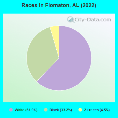
- 1,00261.9%White alone
- 53833.2%Black alone
- 734.5%Two or more races
According to our research of Alabama and other state lists, there were 12 registered sex offenders living in Flomaton, Alabama as of May 22, 2024.
The ratio of all residents to sex offenders in Flomaton is 140 to 1.
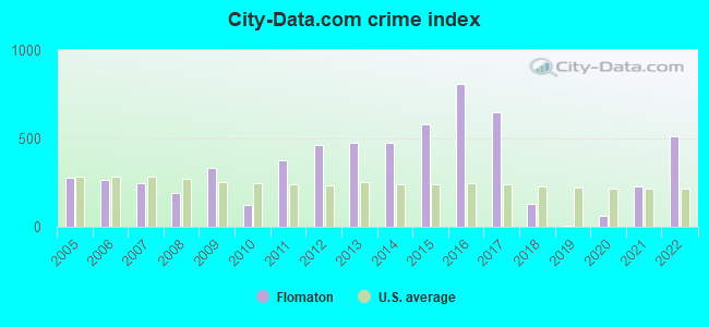
Type |
2009 |
2010 |
2011 |
2012 |
2013 |
2014 |
2015 |
2016 |
2017 |
2018 |
2019 |
2020 |
2021 |
2022 |
|---|---|---|---|---|---|---|---|---|---|---|---|---|---|---|
| Murders (per 100,000) | 0 (0.0) | 0 (0.0) | 0 (0.0) | 0 (0.0) | 0 (0.0) | 0 (0.0) | 0 (0.0) | 2 (142.3) | 2 (142.6) | 0 (0.0) | 0 (0.0) | 0 (0.0) | 0 (0.0) | 1 (68.7) |
| Rapes (per 100,000) | 1 (65.3) | 0 (0.0) | 0 (0.0) | 0 (0.0) | 4 (281.1) | 1 (70.3) | 2 (141.7) | 0 (0.0) | 1 (71.3) | 0 (0.0) | 0 (0.0) | 1 (72.0) | 0 (0.0) | 1 (68.7) |
| Robberies (per 100,000) | 1 (65.3) | 0 (0.0) | 0 (0.0) | 2 (139.1) | 1 (70.3) | 2 (140.6) | 1 (70.9) | 3 (213.5) | 0 (0.0) | 0 (0.0) | 0 (0.0) | 0 (0.0) | 1 (72.9) | 0 (0.0) |
| Assaults (per 100,000) | 11 (718.0) | 2 (138.9) | 14 (967.5) | 22 (1,530) | 4 (281.1) | 12 (843.9) | 15 (1,063) | 18 (1,281) | 9 (641.5) | 2 (144.7) | 0 (0.0) | 0 (0.0) | 4 (291.8) | 7 (481.1) |
| Burglaries (per 100,000) | 4 (261.1) | 4 (277.8) | 11 (760.2) | 7 (486.8) | 14 (983.8) | 11 (773.6) | 16 (1,134) | 18 (1,281) | 15 (1,069) | 13 (940.7) | 0 (0.0) | 0 (0.0) | 6 (437.6) | 21 (1,443) |
| Thefts (per 100,000) | 35 (2,285) | 26 (1,806) | 36 (2,488) | 26 (1,808) | 32 (2,249) | 47 (3,305) | 43 (3,047) | 31 (2,206) | 29 (2,067) | 7 (506.5) | 1 (73.0) | 1 (72.0) | 35 (2,553) | 36 (2,474) |
| Auto thefts (per 100,000) | 2 (130.5) | 1 (69.4) | 6 (414.7) | 1 (69.5) | 3 (210.8) | 4 (281.3) | 6 (425.2) | 5 (355.9) | 4 (285.1) | 3 (217.1) | 1 (73.0) | 0 (0.0) | 3 (218.8) | 4 (274.9) |
| Arson (per 100,000) | 0 (0.0) | 0 (0.0) | 0 (0.0) | 1 (69.5) | 1 (70.3) | 2 (140.6) | 1 (70.9) | 1 (71.2) | 2 (142.6) | 0 (0.0) | 0 (0.0) | 0 (0.0) | 2 (145.9) | 1 (68.7) |
| City-Data.com crime index | 335.5 | 125.0 | 379.4 | 459.7 | 477.9 | 476.1 | 582.6 | 811.4 | 650.7 | 132.4 | 8.8 | 60.5 | 230.5 | 510.7 |
The City-Data.com crime index weighs serious crimes and violent crimes more heavily. Higher means more crime, U.S. average is 246.1. It adjusts for the number of visitors and daily workers commuting into cities.
Crime rate in Flomaton detailed stats: murders, rapes, robberies, assaults, burglaries, thefts, arson
Full-time law enforcement employees in 2021, including police officers: 12 (8 officers - 8 male; 0 female).
| Officers per 1,000 residents here: | 5.84 |
| Alabama average: | 2.40 |
 Recent articles from our blog. Our writers, many of them Ph.D. graduates or candidates, create easy-to-read articles on a wide variety of topics.

 | What is holding Mobile back? (187 replies) |
| 2019 City Populations (57 replies) |
| Earthquake (3 replies) |
| Earthquake (1 reply) |
| Anyone that can help with some questions about Flomaton? (9 replies) |
| Does Alabama need a more ''pro-urban'' governor?? (28 replies) |
Latest news from Flomaton, AL collected exclusively by city-data.com from local newspapers, TV, and radio stations
Ancestries: American (6.4%), English (5.8%), African (1.7%), Irish (1.3%).
Current Local Time: CST time zone
Elevation: 75 feet
Land area: 5.29 square miles.
Population density: 276 people per square mile (very low).
2 residents are foreign born
| This town: | 0.1% |
| Alabama: | 3.5% |
Median real estate property taxes paid for housing units with mortgages in 2022: $399 (0.3%)
Median real estate property taxes paid for housing units with no mortgage in 2022: $432 (0.4%)
Nearest city with pop. 50,000+: Pensacola, FL  (39.7 miles , pop. 56,255).
Nearest city with pop. 200,000+: Montgomery, AL (109.8 miles , pop. 201,568).
Nearest city with pop. 1,000,000+: Houston, TX (492.4 miles , pop. 1,953,631).
Nearest cities:
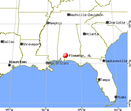
), ), Latitude: 31.01 N, Longitude: 87.26 W
Area code: 251
Single-family new house construction building permits:
- 2022: 1 building, cost: $200,000
- 2021: 1 building, cost: $200,000
- 2020: 1 building, cost: $200,000
- 2019: 1 building, cost: $20,000
- 2018: 1 building, cost: $82,000
- 2017: 1 building, cost: $82,000
- 2013: 1 building, cost: $145,000
- 2012: 1 building, cost: $246,000
- 2010: 3 buildings, average cost: $39,200
- 2008: 6 buildings, average cost: $32,700
- 2007: 3 buildings, average cost: $26,700
- 2006: 4 buildings, average cost: $225,000
- 2005: 3 buildings, average cost: $148,500
- 2002: 7 buildings, average cost: $30,600
- 2000: 3 buildings, average cost: $109,000
- 1999: 3 buildings, average cost: $124,000
- 1998: 3 buildings, average cost: $124,000
- 1997: 2 buildings, average cost: $60,000
| Here: | 3.4% |
| Alabama: | 2.6% |
- Construction (10.6%)
- Public administration (6.2%)
- Accommodation & food services (6.0%)
- Paper (5.7%)
- Educational services (5.3%)
- Health care (4.9%)
- Food & beverage stores (4.4%)
- Construction (17.3%)
- Paper (8.7%)
- Truck transportation (7.7%)
- Public administration (6.4%)
- Professional, scientific, technical services (4.5%)
- Administrative & support & waste management services (4.2%)
- Textile mills & textile products (3.2%)
- Educational services (11.4%)
- Accommodation & food services (10.2%)
- Health care (8.3%)
- Food & beverage stores (7.9%)
- Public administration (5.9%)
- Apparel (5.1%)
- Broadcasting & telecommunications (5.1%)
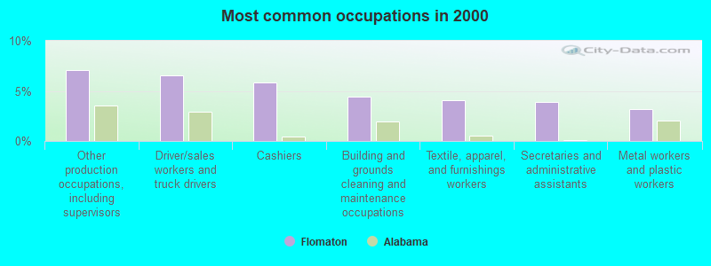
- Other production occupations, including supervisors (7.1%)
- Driver/sales workers and truck drivers (6.5%)
- Cashiers (5.8%)
- Building and grounds cleaning and maintenance occupations (4.4%)
- Textile, apparel, and furnishings workers (4.1%)
- Secretaries and administrative assistants (3.9%)
- Metal workers and plastic workers (3.2%)
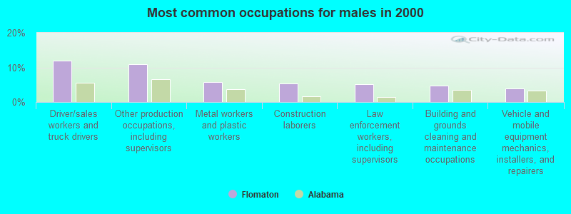
- Driver/sales workers and truck drivers (11.9%)
- Other production occupations, including supervisors (10.9%)
- Metal workers and plastic workers (5.8%)
- Construction laborers (5.4%)
- Law enforcement workers, including supervisors (5.1%)
- Building and grounds cleaning and maintenance occupations (4.8%)
- Vehicle and mobile equipment mechanics, installers, and repairers (3.8%)
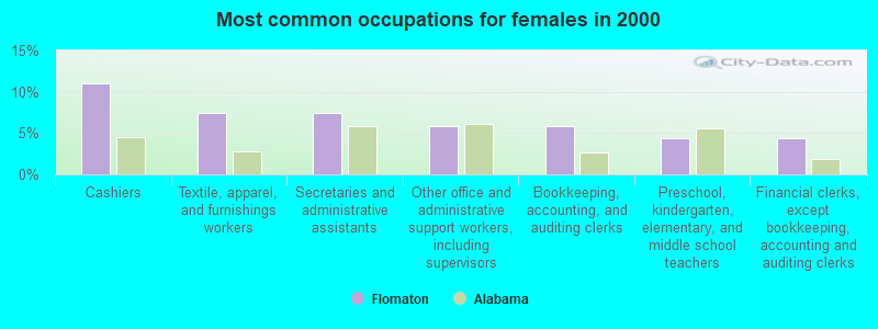
- Cashiers (11.0%)
- Textile, apparel, and furnishings workers (7.5%)
- Secretaries and administrative assistants (7.5%)
- Other office and administrative support workers, including supervisors (5.9%)
- Bookkeeping, accounting, and auditing clerks (5.9%)
- Preschool, kindergarten, elementary, and middle school teachers (4.3%)
- Financial clerks, except bookkeeping, accounting and auditing clerks (4.3%)
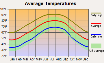
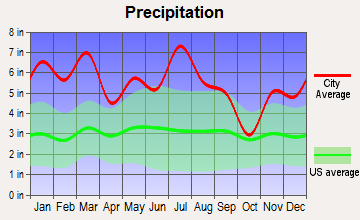
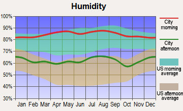
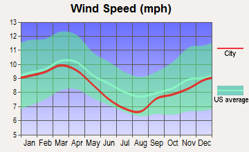
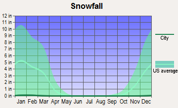
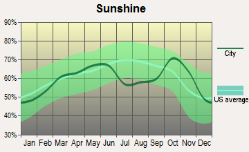
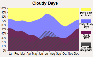
Average climate in Flomaton, Alabama
Based on data reported by over 4,000 weather stations
Tornado activity:
Flomaton-area historical tornado activity is below Alabama state average. It is 31% greater than the overall U.S. average.
On 4/23/1971, a category F4 (max. wind speeds 207-260 mph) tornado 34.1 miles away from the Flomaton town center caused between $5000 and $50,000 in damages.
On 11/3/1968, a category F3 (max. wind speeds 158-206 mph) tornado 13.4 miles away from the town center injured 18 people and caused between $50,000 and $500,000 in damages.
Earthquake activity:
Flomaton-area historical earthquake activity is significantly above Alabama state average. It is 42% greater than the overall U.S. average.On 10/24/1997 at 08:35:17, a magnitude 4.9 (4.8 MB, 4.2 MS, 4.9 LG, Depth: 6.2 mi, Class: Light, Intensity: IV - V) earthquake occurred 7.9 miles away from Flomaton center
On 1/18/1999 at 07:00:53, a magnitude 4.8 (4.8 MB, 4.0 LG, Depth: 0.6 mi) earthquake occurred 165.7 miles away from the city center
On 9/3/2020 at 15:07:53, a magnitude 3.8 (3.8 MW, Depth: 2.5 mi, Class: Light, Intensity: II - III) earthquake occurred 3.9 miles away from Flomaton center
On 11/7/2004 at 11:20:21, a magnitude 4.3 (4.3 MW, Depth: 3.1 mi) earthquake occurred 120.2 miles away from the city center
On 10/26/1997 at 23:27:12, a magnitude 3.7 (3.7 LG, Depth: 6.2 mi) earthquake occurred 6.8 miles away from the city center
On 4/29/2003 at 08:59:39, a magnitude 4.9 (4.4 MB, 4.6 MW, 4.9 LG) earthquake occurred 259.0 miles away from Flomaton center
Magnitude types: regional Lg-wave magnitude (LG), body-wave magnitude (MB), surface-wave magnitude (MS), moment magnitude (MW)
Natural disasters:
The number of natural disasters in Escambia County (21) is greater than the US average (15).Major Disasters (Presidential) Declared: 13
Emergencies Declared: 6
Causes of natural disasters: Hurricanes: 9, Floods: 8, Storms: 8, Tornadoes: 6, Winds: 3, Drought: 1, Snowfall: 1, Winter Storm: 1, Other: 1 (Note: some incidents may be assigned to more than one category).
Hospitals and medical centers near Flomaton:
- CENTURY CARE CENTER (Nursing Home, about 3 miles away; CENTURY, FL)
- NEPHROLOGY CENTER OF CENTURY (Dialysis Facility, about 3 miles away; CENTURY, FL)
- JAY HOSPITAL Acute Care Hospitals (about 9 miles away; JAY, FL)
- ATMORE NURSING CENTER (Nursing Home, about 14 miles away; ATMORE, AL)
- AMEDISYS HOME HEALTH OF BREWTON (Home Health Center, about 14 miles away; BREWTON, AL)
- ATMORE COMMUNITY HOSPITAL Acute Care Hospitals (about 14 miles away; ATMORE, AL)
- COMFORT CARE HOSPICE OF BREWTON (Hospital, about 14 miles away; BREWTON, AL)
Airports located in Flomaton:
- Flomaton Airport (0AL5) (Runways: 1)
Colleges/universities with over 2000 students nearest to Flomaton:
- The University of West Florida (about 33 miles; Pensacola, FL; Full-time enrollment: 10,240)
- James H Faulkner State Community College (about 33 miles; Bay Minette, AL; FT enrollment: 3,703)
- Pensacola State College (about 37 miles; Pensacola, FL; FT enrollment: 8,740)
- Bishop State Community College (about 53 miles; Mobile, AL; FT enrollment: 2,822)
- Columbia Southern University (about 53 miles; Orange Beach, AL; FT enrollment: 14,996)
- Northwest Florida State College (about 57 miles; Niceville, FL; FT enrollment: 5,052)
- University of South Alabama (about 60 miles; Mobile, AL; FT enrollment: 13,228)
Public high schools in Flomaton:
- FLOMATON HIGH SCH (Students: 381, Location: 21200 HIGHWAY 31, Grades: 7-12)
- ESCAMBIA CO ALT SCH (Location: 21280 HIGHWAY 31, Grades: 5-12)
- TURTLE POINT ENVIRONMENTAL SCIENCE CTR (Location: 20959 HIGHWAY 31, Grades: PK-12)
Public elementary/middle school in Flomaton:
- FLOMATON ELEM SCH (Students: 379, Location: 1634 POPLAR ST, Grades: KG-6)
Points of interest:
Notable locations in Flomaton: Flomaton Sewage Lagoon (A), Flomaton Fire Department (B), Flomaton Volunteer Fire Department (C), Flomaton Fire Chief Office (D), Flomaton Public Library (E). Display/hide their locations on the map
Churches in Flomaton include: Little Escambia Baptist Church (A), Rock Church (B), Flomaton Pentecostal Holiness Church (C), First United Methodist Church (D), First Baptist Church (E), Bethel Baptist Church (F), Greater Union Baptist Church (G), Church of Christ (H), Greater Revelation Missionary Baptist Church (I). Display/hide their locations on the map
Cemeteries: Little Escambia Cemetery (1), Rock Cemetery (2). Display/hide their locations on the map
Tourist attraction: Destinations Unlimited Travel (Tours & Charters; 26894 Highway 31).
Drinking water stations with addresses in Flomaton and their reported violations in the past:
FLOMATON WATER WORKS (Population served: 2,493, Groundwater):Past health violations:Past monitoring violations:
- MCL, Monthly (TCR) - In JUL-2010, Contaminant: Coliform. Follow-up actions: St Violation/Reminder Notice (AUG-11-2010), St Public Notif requested (AUG-11-2010), St Public Notif received (SEP-28-2010), St Compliance achieved (FEB-10-2011)
- Lead Consumer Notice - In JAN-01-2012, Contaminant: Lead and Copper Rule. Follow-up actions: St Violation/Reminder Notice (APR-04-2012), St Compliance achieved (APR-20-2012)
- One routine major monitoring violation
- 15 regular monitoring violations
| This town: | 2.4 people |
| Alabama: | 2.5 people |
| This town: | 67.1% |
| Whole state: | 67.8% |
| This town: | 5.2% |
| Whole state: | 4.7% |
No gay or lesbian households reported
Banks with branches in Flomaton (2011 data):
- Escambia County Bank: at 2151 Ringold St, branch established on 1924/01/01. Info updated 2010/05/27: Bank assets: $90.9 mil, Deposits: $73.0 mil, local headquarters, positive income, Mortgage Lending Specialization, 1 total offices
- United Bank: Flomaton Branch at College Street And U.S. Highway 29, branch established on 1972/02/21. Info updated 2006/11/03: Bank assets: $446.4 mil, Deposits: $395.5 mil, headquarters in Atmore, AL, positive income, Commercial Lending Specialization, 18 total offices, Holding Company: United Bancorporation Of Alabama, Inc.
For population 15 years and over in Flomaton:
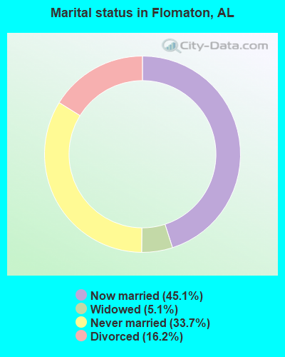
- Never married: 33.7%
- Now married: 45.1%
- Separated: 0.0%
- Widowed: 5.1%
- Divorced: 16.2%
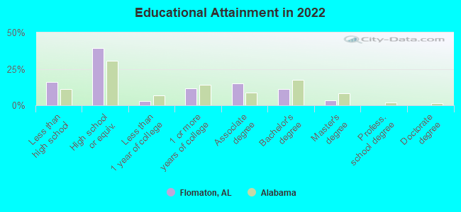
For population 25 years and over in Flomaton:
- High school or higher: 82.0%
- Bachelor's degree or higher: 13.9%
- Graduate or professional degree: 3.2%
- Unemployed: 8.9%
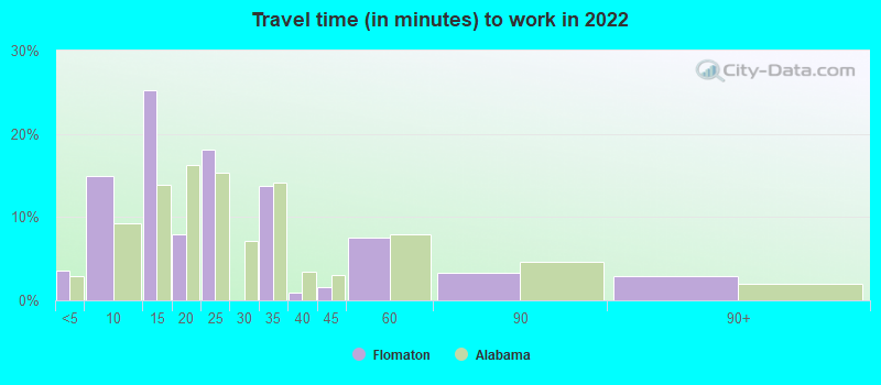
- Mean travel time to work (commute): 20.1 minutes
| Here: | 9.1 |
| Alabama average: | 11.5 |
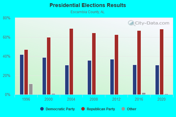
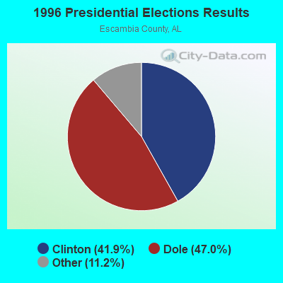
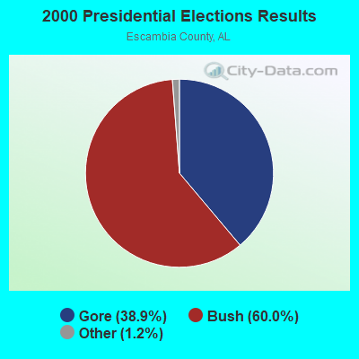
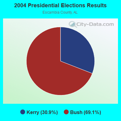
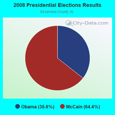
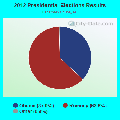
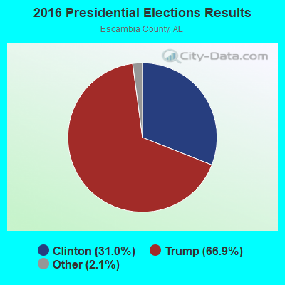
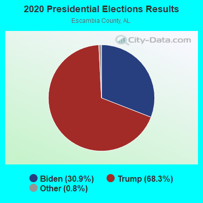
Graphs represent county-level data. Detailed 2008 Election Results
Religion statistics for Flomaton, AL (based on Escambia County data)
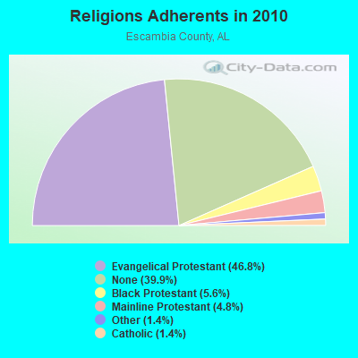
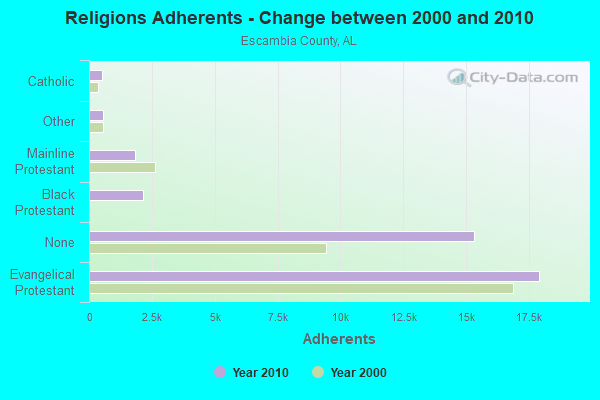
| Religion | Adherents | Congregations |
|---|---|---|
| Evangelical Protestant | 17,917 | 88 |
| Black Protestant | 2,164 | 10 |
| Mainline Protestant | 1,849 | 18 |
| Other | 554 | 6 |
| Catholic | 530 | 2 |
| None | 15,305 | - |
Food Environment Statistics:
| This county: | 2.40 / 10,000 pop. |
| Alabama: | 1.89 / 10,000 pop. |
| Escambia County: | 0.27 / 10,000 pop. |
| State: | 0.65 / 10,000 pop. |
| Escambia County: | 7.72 / 10,000 pop. |
| State: | 6.32 / 10,000 pop. |
| Escambia County: | 5.33 / 10,000 pop. |
| State: | 5.75 / 10,000 pop. |
| Escambia County: | 11.4% |
| Alabama: | 11.8% |
| This county: | 35.2% |
| Alabama: | 31.7% |
| This county: | 12.1% |
| Alabama: | 13.5% |
Health and Nutrition:
| Here: | 48.1% |
| Alabama: | 49.0% |
| This city: | 43.1% |
| Alabama: | 45.7% |
| This city: | 29.5 |
| State: | 28.9 |
| Flomaton: | 19.0% |
| State: | 20.7% |
| Here: | 10.6% |
| Alabama: | 11.0% |
| This city: | 6.8 |
| Alabama: | 6.8 |
| Flomaton: | 30.9% |
| State: | 34.4% |
| This city: | 55.2% |
| Alabama: | 55.2% |
| Here: | 78.2% |
| State: | 79.3% |
More about Health and Nutrition of Flomaton, AL Residents
| Local government employment and payroll (March 2022) | |||||
| Function | Full-time employees | Monthly full-time payroll | Average yearly full-time wage | Part-time employees | Monthly part-time payroll |
|---|---|---|---|---|---|
| Police Protection - Officers | 8 | $27,091 | $40,637 | 0 | $0 |
| Police - Other | 5 | $11,961 | $28,706 | 0 | $0 |
| Water Supply | 4 | $10,709 | $32,127 | 0 | $0 |
| Streets and Highways | 4 | $12,611 | $37,833 | 0 | $0 |
| Local Libraries | 3 | $7,263 | $29,052 | 0 | $0 |
| Sewerage | 3 | $5,641 | $22,564 | 0 | $0 |
| Judicial and Legal | 1 | $2,906 | $34,872 | 0 | $0 |
| Parks and Recreation | 1 | $2,303 | $27,636 | 0 | $0 |
| Firefighters | 1 | $2,923 | $35,076 | 0 | $0 |
| Other Government Administration | 1 | $4,897 | $58,764 | 6 | $4,467 |
| Other and Unallocable | 0 | $0 | 2 | $2,497 | |
| Totals for Government | 31 | $88,305 | $34,183 | 8 | $6,964 |
Flomaton government finances - Expenditure in 2017 (per resident):
- Construction - Regular Highways: $158,000 ($108.37)
- Current Operations - Police Protection: $505,000 ($346.36)
Central Staff Services: $369,000 ($253.09)
Sewerage: $253,000 ($173.53)
Regular Highways: $216,000 ($148.15)
Water Utilities: $203,000 ($139.23)
Parks and Recreation: $153,000 ($104.94)
Libraries: $138,000 ($94.65)
Solid Waste Management: $113,000 ($77.50)
Local Fire Protection: $76,000 ($52.13)
- General - Interest on Debt: $21,000 ($14.40)
Flomaton government finances - Revenue in 2017 (per resident):
- Charges - Sewerage: $234,000 ($160.49)
Miscellaneous Commercial Activities: $1,000 ($0.69)
Other: $1,000 ($0.69)
- Local Intergovernmental - Housing and Community Development: $3,000 ($2.06)
- Miscellaneous - General Revenue - Other: $105,000 ($72.02)
Fines and Forfeits: $16,000 ($10.97)
Rents: $16,000 ($10.97)
Donations From Private Sources: $6,000 ($4.12)
Interest Earnings: $2,000 ($1.37)
- Revenue - Water Utilities: $285,000 ($195.47)
- State Intergovernmental - Highways: $129,000 ($88.48)
Other: $15,000 ($10.29)
- Tax - General Sales and Gross Receipts: $629,000 ($431.41)
Occupation and Business License - Other: $438,000 ($300.41)
Property: $136,000 ($93.28)
Motor Fuels Sales: $122,000 ($83.68)
Other License: $106,000 ($72.70)
Motor Vehicle License: $28,000 ($19.20)
Alcoholic Beverage Sales: $20,000 ($13.72)
Public Utilities Sales: $15,000 ($10.29)
Tobacco Products Sales: $6,000 ($4.12)
Other: $4,000 ($2.74)
Flomaton government finances - Debt in 2017 (per resident):
- Long Term Debt - Beginning Outstanding - Unspecified Public Purpose: $442,000 ($303.16)
Outstanding Unspecified Public Purpose: $381,000 ($261.32)
Retired Unspecified Public Purpose: $61,000 ($41.84)
Beginning Outstanding - Public Debt for Private Purpose: $37,000 ($25.38)
Retired Nonguaranteed - Public Debt for Private Purpose: $37,000 ($25.38)
Flomaton government finances - Cash and Securities in 2017 (per resident):
- Other Funds - Cash and Securities: $540,000 ($370.37)
- Sinking Funds - Cash and Securities: $39,000 ($26.75)
| Businesses in Flomaton, AL | ||||
| Name | Count | Name | Count | |
|---|---|---|---|---|
| Advance Auto Parts | 1 | Kroger | 1 | |
| Church's Chicken | 1 | Lane Furniture | 2 | |
| Hardee's | 1 | Pizza Hut | 1 | |
Strongest AM radio stations in Flomaton:
- WASG (550 AM; 25 kW; ATMORE, AL; Owner: 550 AM, INC)
- WEBY (1330 AM; 25 kW; MILTON, FL; Owner: SPINNAKER LICENSE CORPORATION)
- WNVY (1090 AM; daytime; 10 kW; CANTONMENT, FL; Owner: 1090-AM INC.)
- WBCA (1110 AM; daytime; 10 kW; BAY MINETTE, AL; Owner: SOUTHERN MEDIA COMMUNICATIONS, INC)
- WDLT (660 AM; 10 kW; FAIRHOPE, AL; Owner: CUMULUS LICENSING CORP.)
- WNTM (710 AM; 10 kW; MOBILE, AL; Owner: CLEAR CHANNEL BROADCASTING LICENSES, INC.)
- WYNI (930 AM; 5 kW; MONROEVILLE, AL; Owner: MCKISSICK ENTERPRISES)
- WEBJ (1240 AM; 1 kW; BREWTON, AL; Owner: CANDY CASHMAN SMITH, INDIVIDUAL)
- WBHY (840 AM; daytime; 10 kW; MOBILE, AL; Owner: GOFORTH MEDIA, INC.)
- WJSB (1050 AM; 5 kW; CRESTVIEW, FL; Owner: CRESTVIEW BROADCASTING CO., INC.)
- WSJC (810 AM; 50 kW; MAGEE, MS; Owner: FAMILY TALK RADIO)
- WCOA (1370 AM; 5 kW; PENSACOLA, FL; Owner: CUMULUS LICENSING CORP.)
- WJOX (690 AM; 50 kW; BIRMINGHAM, AL; Owner: CITADEL BROADCASTING COMPANY)
Strongest FM radio stations in Flomaton:
- WPFL (105.1 FM; CENTURY, FL; Owner: TRI-COUNTY BROADCASTING, INC.)
- WYCL (107.3 FM; PENSACOLA, FL; Owner: CONCORD MEDIA GROUP, INC.)
- WXBM-FM (102.7 FM; MILTON, FL; Owner: 6 JOHNSON ROAD LICENSES, INC.)
- WTKX-FM (101.5 FM; PENSACOLA, FL; Owner: CLEAR CHANNEL BROADCASTING LICENSES, INC.)
- WKSJ-FM (94.9 FM; MOBILE, AL; Owner: CLEAR CHANNEL BROADCASTING LICENSES, INC.)
- WJLQ (100.7 FM; PENSACOLA, FL; Owner: CUMULUS LICENSING CORP.)
- WBLX-FM (92.9 FM; MOBILE, AL; Owner: CUMULUS LICENSING CORP.)
- WYOK (104.1 FM; ATMORE, AL; Owner: CUMULUS LICENSING CORP.)
- WMXC (99.9 FM; MOBILE, AL; Owner: CLEAR CHANNEL BROADCASTING LICENSES, INC.)
- WPCS (89.5 FM; PENSACOLA, FL; Owner: PENSACOLA CHRISTIAN COLLEGE, INC)
- WRKH (96.1 FM; MOBILE, AL; Owner: CLEAR CHANNEL BROADCASTING LICENSES, INC.)
- WMEZ (94.1 FM; PENSACOLA, FL; Owner: 6 JOHNSON ROAD LICENSES, INC.)
- WABB-FM (97.5 FM; MOBILE, AL; Owner: WABB-FM, INC.)
- WKNU (106.3 FM; BREWTON, AL; Owner: ELLINGTON RADIO, INC.)
- WYDH (105.9 FM; ATMORE, AL; Owner: SOUTHERN MEDIA COMMUNICATIONS, INC.)
- WGCX (95.7 FM; NAVARRE, FL; Owner: 550 AM, INC)
- WTKE (98.1 FM; HOLT, FL; Owner: CAPSTAR TX LIMITED PARTNERSHIP)
- WPGG (93.3 FM; EVERGREEN, AL; Owner: GULF COAST BROADCASTING COMPANY, INC)
- WZNS (96.5 FM; FORT WALTON BEACH, FL; Owner: CUMULUS LICENSING CORP.)
- WHIL-FM (91.3 FM; MOBILE, AL; Owner: SPRING HILL COLLEGE)
TV broadcast stations around Flomaton:
- WEAR-TV (Channel 3; PENSACOLA, FL; Owner: WEAR LICENSEE, LLC)
- WKRG-TV (Channel 5; MOBILE, AL; Owner: MEDIA GENERAL BROADCASTING OF SOUTH CAROLINA HOLDINGS, INC.)
- WJTC (Channel 44; PENSACOLA, FL; Owner: CLEAR CHANNEL BROADCASTING LICENSES, INC.)
- WMPV-TV (Channel 21; MOBILE, AL; Owner: TRINITY BROADCASTING NETWORK)
- WPMI (Channel 15; MOBILE, AL; Owner: CLEAR CHANNEL BROADCASTING LICENSES, INC.)
- WSRE (Channel 23; PENSACOLA, FL; Owner: DST .BD. OF TRUSTEES PENSACOLA JR. COLLEGE)
- WHBR (Channel 33; PENSACOLA, FL; Owner: CHRISTIAN TELEVISION OF PENSACOLA/MOBILE, INC.)
- WBPG (Channel 55; GULF SHORES, AL; Owner: EMMIS TELEVISION LICENSE CORPORATION)
- WALA-TV (Channel 10; MOBILE, AL; Owner: EMMIS TELEVISION LICENSE CORPORATION)
- WRBM-LP (Channel 60; PRICHARD, AL; Owner: UPPER GULF COAST, L.L.C.)
- WMOE-LP (Channel 12; MOBILE, AL; Owner: TIGER EYE BROADCASTING CORPORATION)
- Flomaton, Alabama
- Fatal accident count27
- Vehicles involved in fatal accidents55
- Fatal accidents involving drunk persons:10
- Fatalities34
- Persons involved in fatal accidents84
- Pedestrians involved in fatal accidents2
- Alabama average
- Fatal accident count19166
- Vehicles involved in fatal accidents28656
- Fatal accidents involving drunk persons6046
- Fatalities21559
- Persons involved in fatal accidents48380
- Pedestrians involved in fatal accidents1345
- National Bridge Inventory (NBI) Statistics
- 15Number of bridges
- 354ft / 108mTotal length
- $43,083,000Total costs
- 46,195Total average daily traffic
- 3,102Total average daily truck traffic
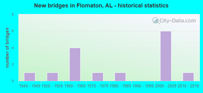
- New bridges - historical statistics
- 11940-1949
- 11950-1959
- 41960-1969
- 11970-1979
- 11980-1989
- 62000-2009
- 12010-2019
FCC Registered Cell Phone Towers:
1 (See the full list of FCC Registered Cell Phone Towers in Flomaton)FCC Registered Antenna Towers:
106 (See the full list of FCC Registered Antenna Towers)FCC Registered Broadcast Land Mobile Towers:
15 (See the full list of FCC Registered Broadcast Land Mobile Towers in Flomaton, AL)FCC Registered Microwave Towers:
7- WPFL Studio, 20630 Highway 31 (Lat: 31.007556 Lon: -87.278583), Type: Tower, Structure height: 13.7 m, Overall height: 16.7 m, Call Sign: WPOT916,
Assigned Frequencies: 949.000 MHz, Grant Date: 06/30/1999, Expiration Date: 02/01/2028, Registrant: Graham Brock, Inc., St. Simons Island, GA 31522-7466, Phone: (912) 638-8028, Fax: (912) 638-7722, Email:
- Flomation, Pwr Substation On Us Hwy 31, 1.8 Mi Nw (Lat: 31.011389 Lon: -87.288056), Type: Tower, Structure height: 76.2 m, Overall height: 77.7 m, Call Sign: WPSE610,
Assigned Frequencies: 6635.00 MHz, 6615.00 MHz, Grant Date: 03/29/2001, Expiration Date: 03/29/2011, Cancellation Date: 09/03/2004, Certifier: Rosemarie Nelson, Registrant: Mcdermott Will & Emery LLP, 600 Thirteenth Street, Nw, Washington, DC 20005-3096, Phone: (202) 756-8283, Fax: (202) 756-8087, Email:
- Flomaton31, 593 Phillips Road (024543 / Flomaton) (Lat: 31.027778 Lon: -87.243139), Type: Gtower, Structure height: 77.1 m, Call Sign: WQPD743,
Assigned Frequencies: 928.131 MHz, 952.131 MHz, Grant Date: 04/21/2022, Expiration Date: 04/17/2032, Certifier: Kevin Dumas, Registrant: Crenshaw Communications Consulting, Lcc., Harvey Mitchell Parkway, College Station, TX 77842, Phone: (832) 617-0217, Email:
- FLOMATON, 1.5 Miles Nne Of Us31 & Sr 113 (Lat: 31.037972 Lon: -87.243750), Type: Gtower, Structure height: 54.8 m, Overall height: 57.9 m, Call Sign: WQQP254, Licensee ID: L01852059,
Assigned Frequencies: 6063.80 MHz, Grant Date: 02/06/2013, Expiration Date: 02/06/2023, Cancellation Date: 05/10/2017, Certifier: Chris Negron, Registrant: Southern Light, LLC, 156 St. Anthony St., Mobile, AL 36603, Phone: (251) 662-1170, Email:
- FLOMATON, Pwr Substation On Us Hwy 31, 1.8 Mi Nw (Lat: 31.011361 Lon: -87.287944), Type: Ltower, Structure height: 76.2 m, Overall height: 81.7 m, Call Sign: WQZH939,
Assigned Frequencies: 11465.0 MHz, 11505.0 MHz, 11465.0 MHz, 11505.0 MHz, 11465.0 MHz, 11505.0 MHz, 11465.0 MHz, 11505.0 MHz, 11465.0 MHz, 11505.0 MHz... (+22 more), Grant Date: 05/23/2017, Expiration Date: 05/23/2027, Certifier: Larry F Butts, Registrant: Southern Company Services, 600 N. 18th St / Bin 5n-5409, Birmingham, AL 35203, Phone: (205) 257-7600, Fax: (205) 257-2134, Email:
- STATION, Apco Substation On Us Hwy 31 1.8 Mi Nw Of (Lat: 31.011833 Lon: -87.287750), Overall height: 77.7 m, Call Sign: WAK205,
Assigned Frequencies: 6635.00 MHz, 6615.00 MHz, Grant Date: 08/23/1995, Expiration Date: 08/23/2000, Cancellation Date: 04/01/2001, Phone: (205) 250-2561
- Houston & Fourth Sts (Lat: 31.001000 Lon: -87.262194), Overall height: 65.5 m, Call Sign: WLU979, Licensee ID: L00008228,
Assigned Frequencies: 5945.20 MHz, 6004.50 MHz, 6063.80 MHz, Grant Date: 11/26/1991, Expiration Date: 08/01/2000, Cancellation Date: 07/19/1999, Registrant: Bellsouth Telecommunications Incorporated, 22j64 Bsc 675 W Peachtree St Ne, Atlanta, GA 30375
FCC Registered Amateur Radio Licenses:
17 (See the full list of FCC Registered Amateur Radio Licenses in Flomaton)FAA Registered Aircraft:
10 (See the full list of FAA Registered Aircraft in Flomaton)| Most common first names in Flomaton, AL among deceased individuals | ||
| Name | Count | Lived (average) |
|---|---|---|
| James | 36 | 70.2 years |
| Mary | 27 | 73.4 years |
| William | 26 | 73.8 years |
| John | 24 | 71.3 years |
| Robert | 17 | 70.7 years |
| Willie | 14 | 71.9 years |
| George | 12 | 72.5 years |
| Henry | 12 | 69.7 years |
| Charles | 11 | 67.4 years |
| Annie | 10 | 77.8 years |
| Most common last names in Flomaton, AL among deceased individuals | ||
| Last name | Count | Lived (average) |
|---|---|---|
| Johnson | 45 | 71.5 years |
| Lambeth | 34 | 75.2 years |
| White | 25 | 71.4 years |
| Boutwell | 23 | 71.5 years |
| Odom | 21 | 70.0 years |
| Bell | 20 | 68.7 years |
| Knowles | 19 | 76.2 years |
| Smith | 14 | 69.5 years |
| Carter | 13 | 72.6 years |
| Jones | 12 | 81.0 years |
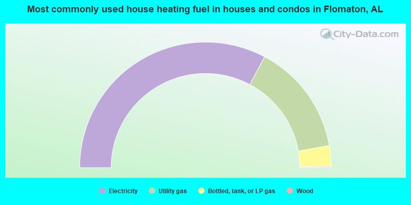
- 65.6%Electricity
- 28.8%Utility gas
- 5.3%Bottled, tank, or LP gas
- 0.3%Wood
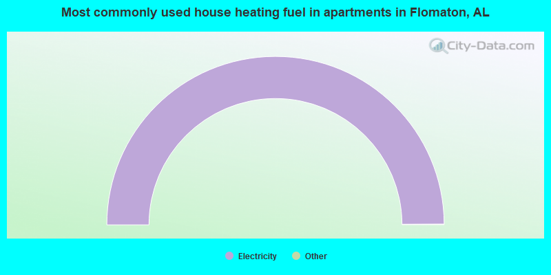
- 100.0%Electricity
Flomaton compared to Alabama state average:
- Median household income below state average.
- Median house value below state average.
- Hispanic race population percentage significantly below state average.
- Median age below state average.
- Foreign-born population percentage significantly below state average.
- Length of stay since moving in significantly above state average.
- Number of college students below state average.