Folsom, Alabama
Submit your own pictures of this place and show them to the world
- OSM Map
- General Map
- Google Map
- MSN Map

| Males: 1,508 | |
| Females: 1,503 |
| Median resident age: | 37.3 years |
| Alabama median age: | 35.8 years |
Zip code: 36270
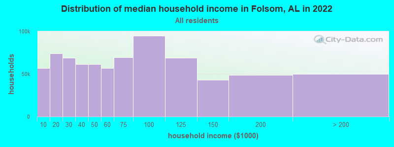
| Folsom: | $44,573 |
| AL: | $59,674 |
Estimated per capita income in 2022: $24,240 (it was $12,284 in 2000)
Folsom CCD income, earnings, and wages data
Estimated median house or condo value in 2022: $178,502 (it was $61,600 in 2000)
| Folsom: | $178,502 |
| AL: | $200,900 |
Detailed information about poverty and poor residents in Folsom, AL
Compare current foreclosures near Folsom, AL:
| Photo | Address | Area | Beds / Baths | Price | Details |
|---|---|---|---|---|---|

|
#1
Mountain Creek Rd
Bowdon, GA 30108
|
2,170 sq. feet
|
2 baths 4 beds |
show details | |

|
#2
County Road 98
Ranburne, AL 36273
|
1,400 sq. feet
|
1 baths 2 beds |
show details | |

|
#3
Copeland St
Bowdon, GA 30108
|
2,354 sq. feet
|
2 baths 3 beds |
show details | |

|
#4
Wedowee St
Bowdon, GA 30108
|
658 sq. feet
|
1 baths 2 beds |
show details | |

|
#5
County Road 62
Heflin, AL 36264
|
- sq. feet
|
2 baths 4 beds |
show details | |

|
#6
Rance Foster Rd
Bowdon, GA 30108
|
1,764 sq. feet
|
2 baths 3 beds |
show details | |

|
#7
N Carroll St
Bowdon, GA 30108
|
1,370 sq. feet
|
2 baths 3 beds |
show details | |

|
#8
W College St
Bowdon, GA 30108
|
3,096 sq. feet
|
2 baths 3 beds |
show details | |

|
#9
Ketchemedoggie Rd
Lineville, AL 36266
|
1,092 sq. feet
|
1 baths - beds |
show details | |

|
#10
Cragford Rd
Cragford, AL 36255
|
- sq. feet
|
- baths - beds |
show details |
| Photo | Address | Area | Beds / Baths | Price | Details |
|---|---|---|---|---|---|

|
#11
Duke Dr
Heflin, AL 36264
|
- sq. feet
|
- baths - beds |
show details | |

|
#12
W Highway 166
Carrollton, GA 30117
|
- sq. feet
|
- baths - beds |
show details | |

|
#13
County Road 59
Heflin, AL 36264
|
- sq. feet
|
- baths - beds |
show details | |

|
#14
Highway 46
Heflin, AL 36264
|
- sq. feet
|
- baths - beds |
show details | |

|
#15
County Road 329
Wedowee, AL 36278
|
- sq. feet
|
- baths - beds |
show details | |

|
#16
Murphy Dr
Heflin, AL 36264
|
- sq. feet
|
- baths - beds |
show details | |

|
#17
County Road 59
Roanoke, AL 36274
|
- sq. feet
|
- baths - beds |
show details | |

|
#18
County Road 65
Roanoke, AL 36274
|
- sq. feet
|
- baths - beds |
show details | |

|
#19
County Road 33
Wedowee, AL 36278
|
- sq. feet
|
- baths - beds |
show details | |

|
#20
County Road 65
Roanoke, AL 36274
|
- sq. feet
|
- baths - beds |
show details |
| Photo | Address | Area | Beds / Baths | Price | Details |
|---|---|---|---|---|---|

|
#21
County Road 65
Roanoke, AL 36274
|
- sq. feet
|
- baths - beds |
show details | |

|
#22
County Road 622
Woodland, AL 36280
|
2,304 sq. feet
|
- baths - beds |
show details | |

|
#23
County Road 48
Ranburne, AL 36273
|
- sq. feet
|
- baths - beds |
show details | |

|
#24
County Road 33
Wedowee, AL 36278
|
- sq. feet
|
- baths - beds |
show details | |

|
#25
County Road 33
Wedowee, AL 36278
|
- sq. feet
|
- baths - beds |
show details | |

|
#26
County Road 43
Heflin, AL 36264
|
- sq. feet
|
- baths - beds |
show details | |

|
#27
Yates Rd
Franklin, GA 30217
|
- sq. feet
|
- baths - beds |
show details | |

|
#28
County Road 819
Heflin, AL 36264
|
- sq. feet
|
- baths - beds |
show details | |

|
#29
Mill St
Bowdon, GA 30108
|
- sq. feet
|
- baths - beds |
show details | |

|
#30
Highway 49
Lineville, AL 36266
|
- sq. feet
|
- baths - beds |
show details |
| Photo | Address | Area | Beds / Baths | Price | Details |
|---|---|---|---|---|---|

|
#31
County Road 26
Wedowee, AL 36278
|
- sq. feet
|
- baths - beds |
show details | |

|
#32
Eastwood Cir # 2a
Bowdon, GA 30108
|
- sq. feet
|
- baths - beds |
show details | |

|
#33
County Road 630
Roanoke, AL 36274
|
- sq. feet
|
- baths - beds |
show details | |

|
#34
County Road 699
Roanoke, AL 36274
|
- sq. feet
|
- baths - beds |
show details | |

|
#35
Mclain St
Lineville, AL 36266
|
- sq. feet
|
- baths - beds |
show details | |

|
#36
Knowles Ave
Lineville, AL 36266
|
1,943 sq. feet
|
- baths - beds |
show details | |

|
#37
Oak Grove Rd
Lineville, AL 36266
|
- sq. feet
|
- baths - beds |
show details | |

|
#38
County Road 268
Roanoke, AL 36274
|
- sq. feet
|
- baths - beds |
show details | |

|
#39
Highway 431
Heflin, AL 36264
|
- sq. feet
|
- baths - beds |
show details | |

|
#40
Woodland Cir
Lineville, AL 36266
|
- sq. feet
|
- baths - beds |
show details |
| Photo | Address | Area | Beds / Baths | Price | Details |
|---|---|---|---|---|---|

|
#41
Oak St
Lineville, AL 36266
|
- sq. feet
|
- baths - beds |
show details | |

|
#42
Highway 49
Lineville, AL 36266
|
1,152 sq. feet
|
- baths - beds |
show details | |

|
#43
Bedwell St Apt A2
Heflin, AL 36264
|
- sq. feet
|
- baths - beds |
show details | |

|
#44
Almon St # 3
Heflin, AL 36264
|
- sq. feet
|
- baths - beds |
show details | |

|
#45
Ridgeview Pkwy
Bowdon, GA 30108
|
- sq. feet
|
- baths - beds |
show details | |

|
#46
County Road 4
Wedowee, AL 36278
|
2,560 sq. feet
|
- baths - beds |
show details | |

|
#47
County Road 87
Roanoke, AL 36274
|
- sq. feet
|
- baths - beds |
show details | |

|
#48
County Road 33
Wedowee, AL 36278
|
- sq. feet
|
- baths - beds |
show details | |

|
#49
County Road 3102
Roanoke, AL 36274
|
- sq. feet
|
- baths - beds |
show details | |

|
Check over 1 million property listings on Foreclosure.com!
|
browse all offers | |||

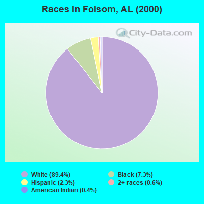
- 2,69589.4%White alone
- 2197.3%Black alone
- 682.3%Hispanic
- 180.6%Two or more races
- 120.4%American Indian alone
- 20.07%Other race alone
- 10.03%Asian alone
 Recent articles from our blog. Our writers, many of them Ph.D. graduates or candidates, create easy-to-read articles on a wide variety of topics.
Current Local Time: CST time zone
Land area: 137.9 square miles.
Population density: 22 people per square mile (very low).

| Folsom CCD: | 0.3% ($199) |
| Alabama: | 0.4% ($289) |
Nearest city with pop. 50,000+: Marietta, GA  (66.3 miles , pop. 58,748).
Nearest city with pop. 200,000+: Atlanta, GA (67.6 miles , pop. 416,474).
Nearest city with pop. 1,000,000+: Chicago, IL (593.4 miles , pop. 2,896,016).
Nearest cities:
), ), ), Latitude: 33.43 N, Longitude: 85.51 W
Area code commonly used in this area: 256

| Here: | 2.6% |
| Alabama: | 2.6% |
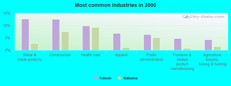
- Metal & metal products (12.7%)
- Construction (12.5%)
- Health care (9.8%)
- Apparel (6.9%)
- Public administration (6.4%)
- Furniture & related product manufacturing (4.7%)
- Agriculture, forestry, fishing & hunting (4.3%)
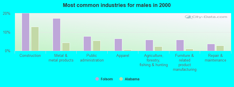
- Construction (19.9%)
- Metal & metal products (17.3%)
- Public administration (7.7%)
- Apparel (6.5%)
- Agriculture, forestry, fishing & hunting (5.9%)
- Furniture & related product manufacturing (5.9%)
- Repair & maintenance (3.7%)
- Health care (21.0%)
- Apparel (7.4%)
- Metal & metal products (7.2%)
- Educational services (6.6%)
- Accommodation & food services (5.5%)
- Personal & laundry services (5.0%)
- Public administration (4.8%)
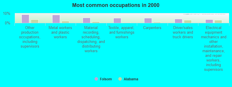
- Other production occupations, including supervisors (8.7%)
- Metal workers and plastic workers (8.4%)
- Material recording, scheduling, dispatching, and distributing workers (5.5%)
- Textile, apparel, and furnishings workers (5.2%)
- Carpenters (5.0%)
- Driver/sales workers and truck drivers (4.2%)
- Electrical equipment mechanics and other installation, maintenance, and repair workers, including supervisors (3.6%)
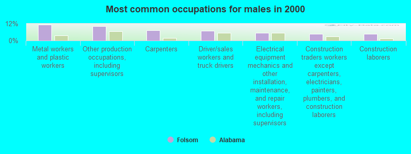
- Metal workers and plastic workers (11.3%)
- Other production occupations, including supervisors (10.4%)
- Carpenters (7.1%)
- Driver/sales workers and truck drivers (6.8%)
- Electrical equipment mechanics and other installation, maintenance, and repair workers, including supervisors (5.4%)
- Construction traders workers except carpenters, electricians, painters, plumbers, and construction laborers (4.6%)
- Construction laborers (4.6%)
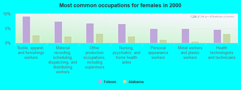
- Textile, apparel, and furnishings workers (9.2%)
- Material recording, scheduling, dispatching, and distributing workers (7.4%)
- Other production occupations, including supervisors (6.8%)
- Nursing, psychiatric, and home health aides (6.6%)
- Personal appearance workers (5.0%)
- Metal workers and plastic workers (5.0%)
- Health technologists and technicians (4.6%)
Average climate in Folsom, Alabama
Based on data reported by over 4,000 weather stations


Tornado activity:
Folsom-area historical tornado activity is near Alabama state average. It is 95% greater than the overall U.S. average.
On 5/27/1973, a category F4 (max. wind speeds 207-260 mph) tornado 15.4 miles away from the Folsom place center killed 7 people and injured 199 people and caused between $5,000,000 and $50,000,000 in damages.
On 5/1/1953, a category F4 tornado 16.7 miles away from the place center killed 7 people and injured 12 people and caused between $50,000 and $500,000 in damages.
Earthquake activity:
Folsom-area historical earthquake activity is significantly above Alabama state average. It is 79% greater than the overall U.S. average.On 4/29/2003 at 08:59:39, a magnitude 4.9 (4.4 MB, 4.6 MW, 4.9 LG, Class: Light, Intensity: IV - V) earthquake occurred 73.6 miles away from Folsom center
On 1/18/1999 at 07:00:53, a magnitude 4.8 (4.8 MB, 4.0 LG, Depth: 0.6 mi) earthquake occurred 100.8 miles away from Folsom center
On 4/29/2003 at 08:59:39, a magnitude 4.6 (4.6 MW, Depth: 12.3 mi) earthquake occurred 73.6 miles away from the city center
On 8/2/1974 at 08:52:09, a magnitude 4.9 (4.3 MB, 4.9 LG) earthquake occurred 176.6 miles away from the city center
On 10/24/1997 at 08:35:17, a magnitude 4.9 (4.8 MB, 4.2 MS, 4.9 LG, Depth: 6.2 mi) earthquake occurred 190.2 miles away from Folsom center
On 6/24/1975 at 11:11:36, a magnitude 4.5 (4.5 MB) earthquake occurred 135.7 miles away from the city center
Magnitude types: regional Lg-wave magnitude (LG), body-wave magnitude (MB), surface-wave magnitude (MS), moment magnitude (MW)
Natural disasters:
The number of natural disasters in Randolph County (18) is near the US average (15).Major Disasters (Presidential) Declared: 9
Emergencies Declared: 6
Causes of natural disasters: Floods: 8, Storms: 8, Hurricanes: 6, Tornadoes: 4, Winds: 2, Drought: 1, Snowfall: 1, Tropical Storm: 1, Winter Storm: 1, Other: 1 (Note: some incidents may be assigned to more than one category).
Colleges/universities with over 2000 students nearest to Folsom:
- Southern Union State Community College (about 22 miles; Wadley, AL; Full-time enrollment: 4,120)
- University of West Georgia (about 26 miles; Carrollton, GA; FT enrollment: 10,358)
- West Georgia Technical College (about 26 miles; Waco, GA; FT enrollment: 4,768)
- Jacksonville State University (about 31 miles; Jacksonville, AL; FT enrollment: 7,566)
- Gadsden State Community College (about 48 miles; Gadsden, AL; FT enrollment: 4,650)
- Georgia Highlands College (about 54 miles; Rome, GA; FT enrollment: 4,071)
- Auburn University (about 58 miles; Auburn University, AL; FT enrollment: 22,741)
Points of interest:
Notable locations in Folsom: Newell Volunteer Fire Department (A), Morrison Crossroad Volunteer Fire Department (B), Fosters Crossroads Volunteer Fire Department (C). Display/hide their locations on the map
Churches in Folsom include: Mount Gilead Baptist Church (A), New Area Church (B), New Home Church (C), Oak Grove Church (D), Lecta Church (E), Pine Hill Church (F), Pleasant Hill Church (G), Levins Chapel (H), Jordan Chapel (I). Display/hide their locations on the map
Cemeteries: Old Cool Spring Cemetery (1), Fowler Cemetery (2), Williams Cemetery (3), Rice Cemetery (4), Valley Grove Cemetery (5), Antioch Cemetery (6), Corinth Cemetery (7). Display/hide their locations on the map
Reservoirs: Nelson Lake (A), Boyd Lake (B), Brady Lake (C), Grays Lake (D). Display/hide their locations on the map
Streams, rivers, and creeks: Sandy Creek (A), Panther Branch (B), Mud Creek (C), Mill Branch (D), Knight Branch (E), Kidd Branch (F), Hunter Branch (G), Cohobadiah Creek (H), Henson Branch (I). Display/hide their locations on the map
| This place: | 2.5 people |
| Alabama: | 2.5 people |
| This place: | 74.5% |
| Whole state: | 67.8% |
| This place: | 4.6% |
| Whole state: | 4.7% |
Likely homosexual households (counted as self-reported same-sex unmarried-partner households)
- Lesbian couples: 0.4% of all households
- Gay men: 0.4% of all households
| This place: | 15.7% |
| Whole state: | 16.1% |
| This place: | 6.3% |
| Whole state: | 7.3% |
For population 15 years and over in Folsom:
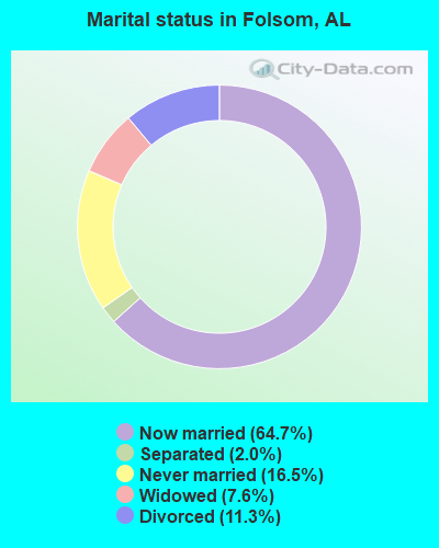
- Never married: 16.5%
- Now married: 64.7%
- Separated: 2.0%
- Widowed: 7.6%
- Divorced: 11.3%
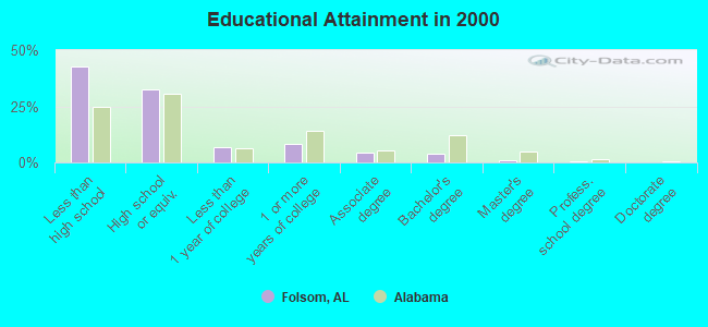
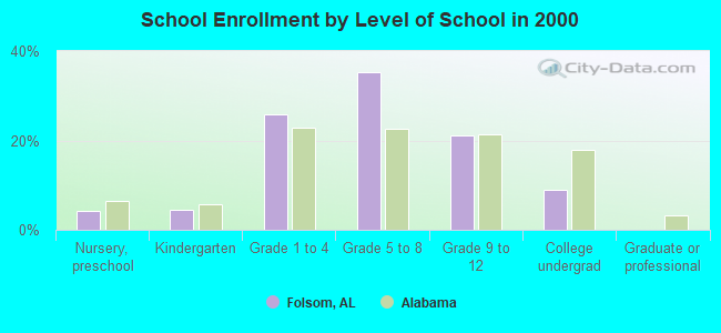
For population 25 years and over in Folsom:
- High school or higher: 57.0%
- Bachelor's degree or higher: 5.3%
- Graduate or professional degree: 1.5%
- Unemployed: 4.9%
- Mean travel time to work (commute): 43.0 minutes
| Here: | 15.0 |
| Alabama average: | 13.2 |
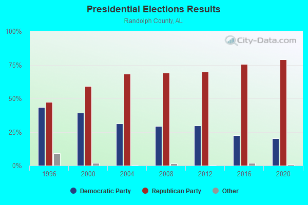
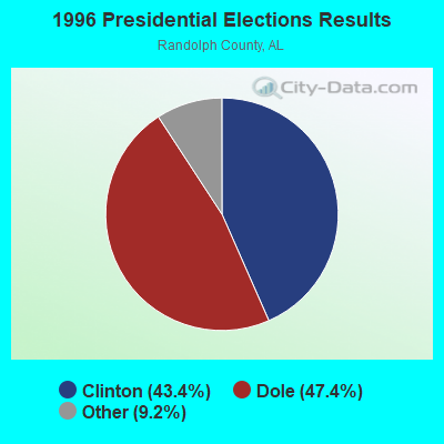
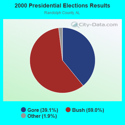
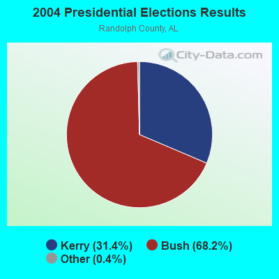
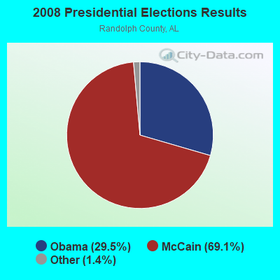

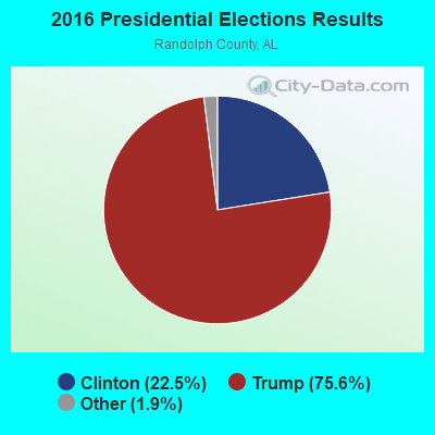
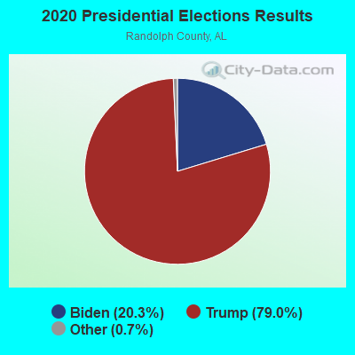
Graphs represent county-level data. Detailed 2008 Election Results
Religion statistics for Folsom, AL (based on Randolph County data)
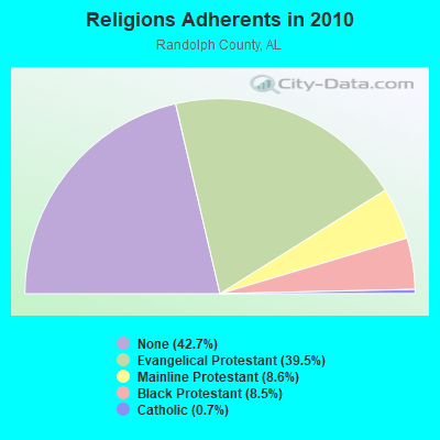
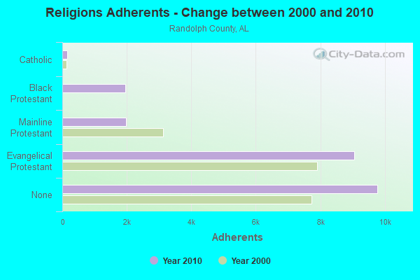
| Religion | Adherents | Congregations |
|---|---|---|
| Evangelical Protestant | 9,053 | 69 |
| Mainline Protestant | 1,978 | 26 |
| Black Protestant | 1,953 | 9 |
| Catholic | 149 | 1 |
| Other | 1 | 1 |
| None | 9,779 | - |
Food Environment Statistics:
| Randolph County: | 1.79 / 10,000 pop. |
| Alabama: | 1.89 / 10,000 pop. |
| Here: | 0.45 / 10,000 pop. |
| Alabama: | 0.65 / 10,000 pop. |
| Here: | 10.72 / 10,000 pop. |
| Alabama: | 6.32 / 10,000 pop. |
| Here: | 6.25 / 10,000 pop. |
| Alabama: | 5.75 / 10,000 pop. |
| Here: | 11.7% |
| Alabama: | 11.8% |
| Randolph County: | 31.7% |
| State: | 31.7% |
| Randolph County: | 13.6% |
| State: | 13.5% |
Strongest AM radio stations in Folsom:
- WKNG (1060 AM; daytime; 50 kW; TALLAPOOSA, GA; Owner: WKNG, INC.)
- WNSI (810 AM; 50 kW; JACKSONVILLE, AL; Owner: UNITED BROADCASTING NETWORK, INC.)
- WGST (640 AM; 50 kW; ATLANTA, GA; Owner: CITICASTERS LICENSES, L.P.)
- WZZX (780 AM; daytime; 5 kW; LINEVILLE, AL; Owner: ROBERT A. PERRY)
- WMLB (1160 AM; 50 kW; EAST POINT, GA; Owner: ATLANTA AREA BROADCASTING, INC.)
- WFTD (1080 AM; daytime; 50 kW; MARIETTA, GA; Owner: PRIETO ENTERPRISES, INC.)
- WDJC (850 AM; 50 kW; BIRMINGHAM, AL; Owner: KIMTRON, INC.)
- WCNN (680 AM; 50 kW; NORTH ATLANTA, GA; Owner: DICKEY BROADCASTING COMPANY)
- WSB (750 AM; 50 kW; ATLANTA, GA; Owner: CXR HOLDINGS, INC.)
- WJOX (690 AM; 50 kW; BIRMINGHAM, AL; Owner: CITADEL BROADCASTING COMPANY)
- WGUN (1010 AM; 50 kW; ATLANTA, GA; Owner: WGUN, INC.)
- WAOK (1380 AM; 50 kW; ATLANTA, GA; Owner: INFINITY BROADCASTING OPERATIONS, INC.)
- WAZX (1550 AM; 50 kW; SMYRNA, GA; Owner: GA-MEX BROADCASTING, INC.)
Strongest FM radio stations in Folsom:
- WMAX-FM (105.3 FM; BOWDON, GA; Owner: CLEAR CHANNEL BROADCASTING LICENSES, INC.)
- WTBJ (91.3 FM; OXFORD, AL; Owner: TRINITY CHRISTIAN ACADEMY)
- WVOK-FM (97.9 FM; OXFORD, AL; Owner: WOODARD BROADCASTING CO. INC.)
- WELR-FM (102.3 FM; ROANOKE, AL; Owner: EAGLE'S NEST, INC.)
- WALR-FM (104.1 FM; LA GRANGE, GA; Owner: CXR HOLDINGS, INC.)
- WCKS (102.7 FM; FRUITHURST, AL; Owner: WCKS, INC.)
- WLJS-FM (91.9 FM; JACKSONVILLE, AL; Owner: BD. OF TRUSTEES/JACKSONVILLE STATE UNIVERSITY)
- WASZ (95.5 FM; ASHLAND, AL; Owner: WILLIAMS COMMUNICATIONS, INC.)
- W269AX (101.7 FM; ANNISTON, AL; Owner: BIBLE BROADCASTING NETWORK, INC.)
- WBTR-FM (92.1 FM; CARROLLTON, GA; Owner: WYAI, INC.)
- WTDR (92.7 FM; TALLADEGA, AL; Owner: JACOBS BROADCAST GROUP, INC.)
- WSSY-FM (97.5 FM; TALLADEGA, AL; Owner: GREAT SOUTH RFDC, LLC)
- WUWG (90.7 FM; CARROLLTON, GA; Owner: WEST GEORGIA COLLEGE)
TV broadcast stations around Folsom:
- WCIQ (Channel 7; MOUNT CHEAHA, AL; Owner: ALABAMA EDUCATIONAL TELEVISION COMMISSION)
- W04DB (Channel 4; ATLANTA, GA; Owner: VVILPTV, INC.)
- W29AO (Channel 29; ANNISTON, AL; Owner: WBRC LICENSE, INC.)
- National Bridge Inventory (NBI) Statistics
- 22Number of bridges
- 240ft / 73.1mTotal length
- $45,694,000Total costs
- 8,739Total average daily traffic
- 974Total average daily truck traffic
- 12,376Total future (year 2030) average daily traffic
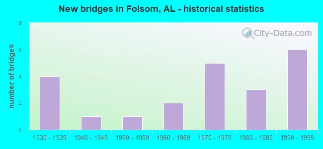
- New bridges - historical statistics
- 41930-1939
- 11940-1949
- 11950-1959
- 21960-1969
- 51970-1979
- 31980-1989
- 61990-1999
FCC Registered Antenna Towers:
7- Elliott York, 703 County Road 206 (Lat: 33.462611 Lon: -85.564778), Type: 109.4, Structure height: 01111 m, Overall height: 106.6 m, Registrant: Southern Communication Services, Inc., X2kbrobi@southernco.Com, Suite D-100, Lawre-nceville, Phone: (770) 995-2714
- Elliott York, 703 County Road 206 (Lat: 33.462611 Lon: -85.564778), Type: 114.3, Structure height: 01111 m, Overall height: 109.7 m, Registrant: Southern Communication Services, Inc., X2kbrobi@southernco.Com, Suite D-100, Lawre-nceville, Phone: (770) 995-2714
- Kevin B Robinson, 703 County Road 206 (Lat: 33.462611 Lon: -85.564778), Type: 114.3, Structure height: 01111 m, Overall height: 109.7 m, Registrant: Southern Communication Services, Inc., X2kbrobi@southernco.Com, Suite D-100, Lawre-nceville, Phone: (770) 995-2714
- Kevin B Robinson, 703 County Road 206 (Lat: 33.462611 Lon: -85.564778), Type: 114.3, Structure height: 01111 m, Overall height: 109.7 m, Registrant: Southern Communication Services, Inc., X2kbrobi@southernco.Com, Suite D-100, Lawre-nceville, Phone: (770) 995-2714
- Jennifer A Sirovica, 703 County Road 206 (Lat: 33.462611 Lon: -85.564778), Type: 114.3, Structure height: 01111 m, Overall height: 109.7 m, Registrant: Horvath Towers Iii, LLC, Jsirovica@horvathcommunications.Com, , South- Bend, Phone: (574) 237-0464
- Jennifer A Sirovica, 703 County Road 206 (Lat: 33.462611 Lon: -85.564778), Type: 114.3, Structure height: 01111 m, Overall height: 109.7 m, Registrant: Horvath Towers Iii, LLC, Jsirovica@horvathcommunications.Com, , South- Bend, Phone: (574) 237-0464
- Greg Thompson, 703 County Road 206 (Lat: 33.462611 Lon: -85.564778), Type: 114.3, Structure height: 01111 m, Overall height: 109.7 m, Registrant: Horvath Towers Iii, LLC, Gthompson@k2towers.Com, , Chagr-in Falls, Phone: (440) 263-8999
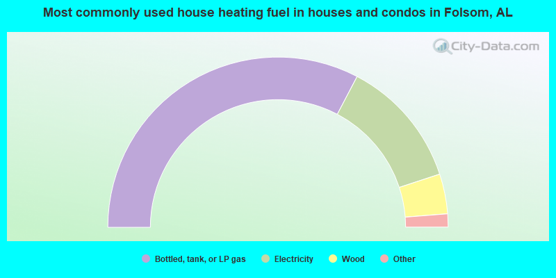
- 65.4%Bottled, tank, or LP gas
- 24.5%Electricity
- 7.6%Wood
- 0.9%Fuel oil, kerosene, etc.
- 0.9%No fuel used
- 0.7%Utility gas
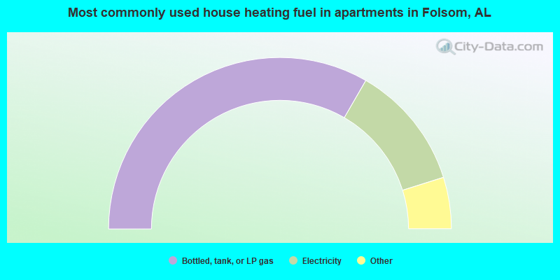
- 66.7%Bottled, tank, or LP gas
- 23.6%Electricity
- 3.6%Wood
- 3.0%Utility gas
- 3.0%Fuel oil, kerosene, etc.
Folsom compared to Alabama state average:
- Unemployed percentage significantly below state average.
- Black race population percentage significantly below state average.
- Hispanic race population percentage below state average.
- Median age below state average.
- Foreign-born population percentage significantly below state average.
- Renting percentage below state average.
- Length of stay since moving in significantly above state average.
- Number of rooms per house significantly below state average.
- House age significantly below state average.
- Number of college students below state average.
- Percentage of population with a bachelor's degree or higher significantly below state average.