Forest, South Carolina
Submit your own pictures of this place and show them to the world
- OSM Map
- General Map
- Google Map
- MSN Map

| Males: 1,463 | |
| Females: 1,415 |
| Median resident age: | 40.7 years |
| South Carolina median age: | 35.4 years |
Zip code: 29671
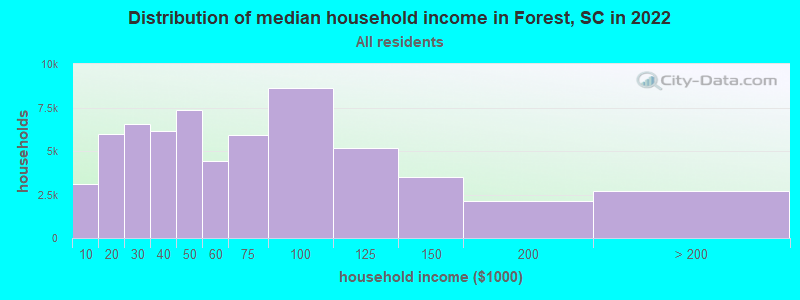
| Forest: | $61,398 |
| SC: | $64,115 |
Estimated per capita income in 2022: $39,940 (it was $23,563 in 2000)
Forest CCD income, earnings, and wages data
Estimated median house or condo value in 2022: $229,910 (it was $85,100 in 2000)
| Forest: | $229,910 |
| SC: | $254,600 |
Mean prices in 2022: all housing units: $258,142; detached houses: $293,254; townhouses or other attached units: $456,920; in 3-to-4-unit structures: $117,374; in 5-or-more-unit structures: $170,502; mobile homes: $80,661; occupied boats, rvs, vans, etc.: $108,127
Detailed information about poverty and poor residents in Forest, SC
Compare current foreclosures near Forest, SC:
| Photo | Address | Area | Beds / Baths | Price | Details |
|---|---|---|---|---|---|

|
#1
N Smith St
Six Mile, SC 29682
|
1,344 sq. feet
|
2 baths 3 beds |
$265,000
|
show details |

|
#2
Ardell Ln
Six Mile, SC 29682
|
- sq. feet
|
2 baths 3 beds |
show details | |

|
#3
Dogwood Lane Ext
Travelers Rest, SC 29690
|
2,266 sq. feet
|
2 baths 3 beds |
show details | |

|
#4
Doe Run
Pickens, SC 29671
|
2,906 sq. feet
|
3 baths 3 beds |
show details | |

|
#5
Hart Cut Rd
Marietta, SC 29661
|
1,518 sq. feet
|
1 baths 3 beds |
show details | |

|
#6
Wilbur St
Easley, SC 29640
|
1,536 sq. feet
|
1 baths 3 beds |
show details | |

|
#7
Mount Tabor Church Rd
Pickens, SC 29671
|
1,333 sq. feet
|
2 baths 3 beds |
show details | |

|
#8
Bearwallow Rd
Sapphire, NC 28774
|
1,104 sq. feet
|
2 baths 3 beds |
show details | |

|
#9
Westchester Rd
Easley, SC 29640
|
1,196 sq. feet
|
2 baths 3 beds |
show details | |

|
#10
Geer Hwy
Travelers Rest, SC 29690
|
3,599 sq. feet
|
2 baths 3 beds |
show details |
| Photo | Address | Area | Beds / Baths | Price | Details |
|---|---|---|---|---|---|

|
#11
Virginia Dr
Liberty, SC 29657
|
3,068 sq. feet
|
2 baths 3 beds |
show details | |

|
#12
Old Seneca Rd
Central, SC 29630
|
1,506 sq. feet
|
2 baths 3 beds |
show details | |

|
#13
Bowen Rd
Easley, SC 29640
|
1,821 sq. feet
|
2 baths 3 beds |
show details | |

|
#14
Alta Vista Dr
Liberty, SC 29657
|
1,898 sq. feet
|
2 baths 3 beds |
show details | |

|
#15
Hedgepath St
Liberty, SC 29657
|
952 sq. feet
|
1 baths 2 beds |
show details | |

|
#16
Crest Way
Easley, SC 29640
|
1,595 sq. feet
|
2 baths 4 beds |
show details | |

|
#17
Adger Rd
Easley, SC 29642
|
2,224 sq. feet
|
2 baths 3 beds |
show details | |

|
#18
E Beattie St
Liberty, SC 29657
|
832 sq. feet
|
1 baths 2 beds |
show details | |

|
#19
W Beattie St
Liberty, SC 29657
|
832 sq. feet
|
1 baths 2 beds |
show details | |

|
#20
Cameron Cir
Pisgah Forest, NC 28768
|
3,084 sq. feet
|
2 baths 3 beds |
show details |
| Photo | Address | Area | Beds / Baths | Price | Details |
|---|---|---|---|---|---|

|
#21
N Norris Dr
Liberty, SC 29657
|
2,724 sq. feet
|
2 baths 4 beds |
show details | |

|
#22
Duncan Rd
Travelers Rest, SC 29690
|
1,279 sq. feet
|
2 baths 3 beds |
show details | |

|
#23
Farrs Bridge Rd
Greenville, SC 29611
|
2,200 sq. feet
|
2 baths 4 beds |
show details | |

|
#24
Kingswood Dr
Greenville, SC 29611
|
1,146 sq. feet
|
1 baths 3 beds |
show details | |

|
#25
Lorraine Dr
Travelers Rest, SC 29690
|
1,200 sq. feet
|
1 baths 3 beds |
show details | |

|
#26
Bridwell Rd
Six Mile, SC 29682
|
1,240 sq. feet
|
2 baths 3 beds |
show details | |

|
#27
Orchard Dr
Liberty, SC 29657
|
1,115 sq. feet
|
1 baths 3 beds |
show details | |

|
#28
Farrs Bridge Rd
Easley, SC 29640
|
2,094 sq. feet
|
2 baths 3 beds |
show details | |

|
#29
Hunts Bridge Rd
Easley, SC 29640
|
1,530 sq. feet
|
2 baths 3 beds |
show details | |

|
#30
Mount Tabor Church Rd
Pickens, SC 29671
|
1,333 sq. feet
|
2 baths 3 beds |
show details |
| Photo | Address | Area | Beds / Baths | Price | Details |
|---|---|---|---|---|---|

|
#31
Nix Ln
Sunset, SC 29685
|
1,412 sq. feet
|
2 baths 3 beds |
show details | |

|
#32
Cedar Ridge Dr
Liberty, SC 29657
|
1,498 sq. feet
|
2 baths 3 beds |
show details | |

|
#33
Lost Valley Rd
Pickens, SC 29671
|
960 sq. feet
|
1 baths 2 beds |
show details | |

|
#34
Spur Rd
Six Mile, SC 29682
|
1,688 sq. feet
|
2 baths 3 beds |
show details | |

|
#35
Bates Rd
Liberty, SC 29657
|
1,680 sq. feet
|
2 baths 3 beds |
show details | |

|
#36
Cedar Rock Church Rd
Easley, SC 29640
|
1,402 sq. feet
|
2 baths 3 beds |
show details | |

|
#37
Upper Lake Dr
Easley, SC 29640
|
2,143 sq. feet
|
2 baths 3 beds |
show details | |

|
#38
Hayes Rd
Pickens, SC 29671
|
1,614 sq. feet
|
1 baths 3 beds |
show details | |

|
#39
Bivens St
Pickens, SC 29671
|
1,126 sq. feet
|
1 baths 3 beds |
show details | |

|
#40
W Main St # B
Pickens, SC 29671
|
- sq. feet
|
- baths - beds |
show details |
| Photo | Address | Area | Beds / Baths | Price | Details |
|---|---|---|---|---|---|

|
#41
Beattie Street
Liberty, SC 29657
|
- sq. feet
|
- baths - beds |
show details | |

|
#42
Cannon Drive
Pisgah Forest, NC 28768
|
- sq. feet
|
- baths - beds |
show details | |

|
#43
Smith Cir
Liberty, SC 29657
|
- sq. feet
|
- baths - beds |
show details | |

|
#44
1140
Rosman, NC 28772
|
- sq. feet
|
- baths - beds |
show details | |

|
#45
Cherokee Rose Trl
Marietta, SC 29661
|
- sq. feet
|
- baths - beds |
show details | |

|
#46
Whitefish Way
Marietta, SC 29661
|
2,240 sq. feet
|
- baths - beds |
show details | |

|
#47
Smith Memorial Hwy
Central, SC 29630
|
- sq. feet
|
- baths - beds |
show details | |

|
#48
Main St Ext
Brevard, NC 28712
|
- sq. feet
|
- baths - beds |
show details | |

|
#49
Saluda Dam Rd
Easley, SC 29640
|
- sq. feet
|
- baths - beds |
show details | |

|
Check over 1 million property listings on Foreclosure.com!
|
browse all offers | |||

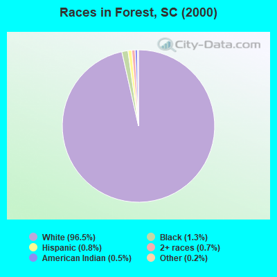
- 2,65796.5%White alone
- 361.3%Black alone
- 210.8%Hispanic
- 190.7%Two or more races
- 140.5%American Indian alone
- 50.2%Other race alone
- 20.07%Asian alone
Races in Forest detailed stats: ancestries, foreign born residents, place of birth
 Recent articles from our blog. Our writers, many of them Ph.D. graduates or candidates, create easy-to-read articles on a wide variety of topics.
Current Local Time: EST time zone
Land area: 113.8 square miles.
Population density: 25 people per square mile (very low).

| Forest CCD: | 0.4% ($339) |
| South Carolina: | 0.6% ($510) |
Nearest city with pop. 50,000+: Greenville, SC  (23.0 miles , pop. 56,002).
Nearest city with pop. 200,000+: Charlotte, NC (109.0 miles , pop. 540,828).
Nearest city with pop. 1,000,000+: Philadelphia, PA (540.9 miles , pop. 1,517,550).
Nearest cities:
), ), ), ), Latitude: 35.01 N, Longitude: 82.74 W
Area code commonly used in this area: 864

| Here: | 2.9% |
| South Carolina: | 3.1% |
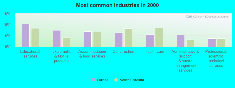
- Educational services (10.3%)
- Textile mills & textile products (7.5%)
- Accommodation & food services (6.9%)
- Construction (6.3%)
- Health care (5.5%)
- Administrative & support & waste management services (5.3%)
- Professional, scientific, technical services (3.8%)
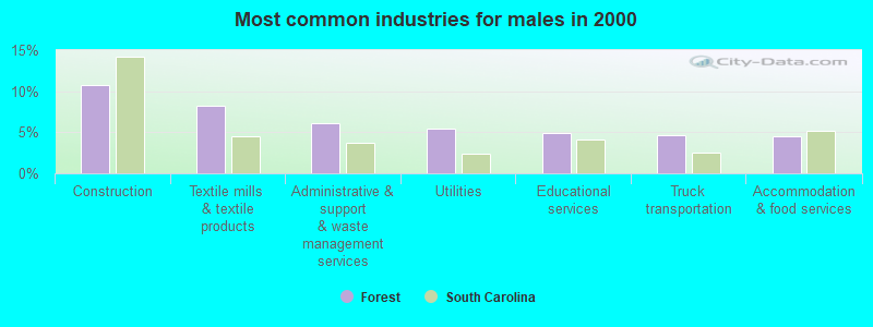
- Construction (10.7%)
- Textile mills & textile products (8.2%)
- Administrative & support & waste management services (6.1%)
- Utilities (5.5%)
- Educational services (5.0%)
- Truck transportation (4.7%)
- Accommodation & food services (4.6%)
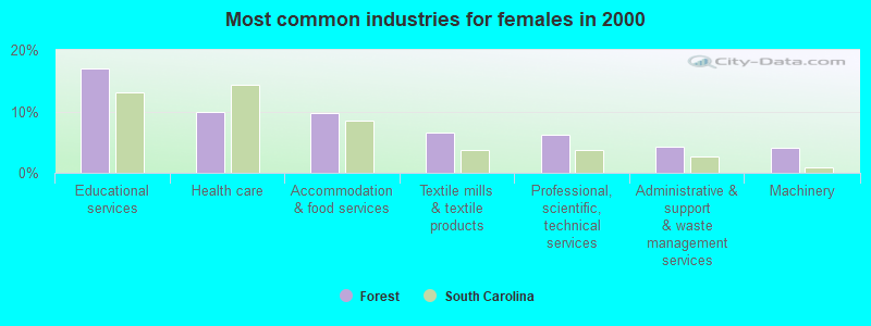
- Educational services (16.9%)
- Health care (9.9%)
- Accommodation & food services (9.8%)
- Textile mills & textile products (6.5%)
- Professional, scientific, technical services (6.2%)
- Administrative & support & waste management services (4.2%)
- Machinery (4.1%)
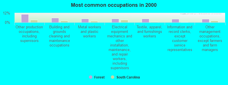
- Other production occupations, including supervisors (10.4%)
- Building and grounds cleaning and maintenance occupations (5.9%)
- Metal workers and plastic workers (4.9%)
- Electrical equipment mechanics and other installation, maintenance, and repair workers, including supervisors (4.9%)
- Textile, apparel, and furnishings workers (4.6%)
- Information and record clerks, except customer service representatives (4.3%)
- Other management occupations, except farmers and farm managers (4.3%)
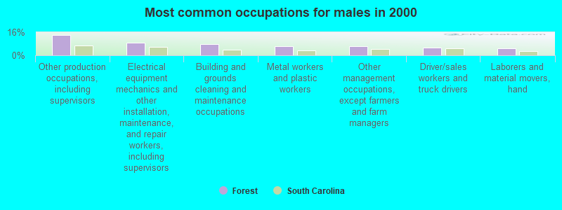
- Other production occupations, including supervisors (14.2%)
- Electrical equipment mechanics and other installation, maintenance, and repair workers, including supervisors (8.8%)
- Building and grounds cleaning and maintenance occupations (7.6%)
- Metal workers and plastic workers (6.3%)
- Other management occupations, except farmers and farm managers (6.1%)
- Driver/sales workers and truck drivers (5.2%)
- Laborers and material movers, hand (5.0%)
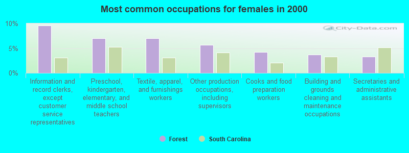
- Information and record clerks, except customer service representatives (9.6%)
- Preschool, kindergarten, elementary, and middle school teachers (7.0%)
- Textile, apparel, and furnishings workers (7.0%)
- Other production occupations, including supervisors (5.7%)
- Cooks and food preparation workers (4.2%)
- Building and grounds cleaning and maintenance occupations (3.7%)
- Secretaries and administrative assistants (3.3%)
Average climate in Forest, South Carolina
Based on data reported by over 4,000 weather stations


(lower is better)
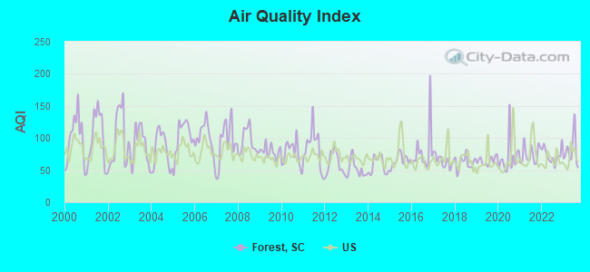
Air Quality Index (AQI) level in 2023 was 79.9. This is about average.
| City: | 79.9 |
| U.S.: | 72.6 |
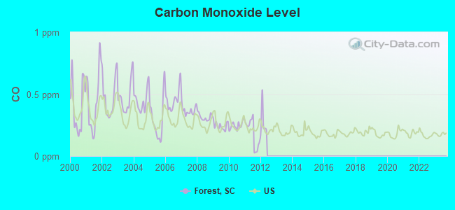
Carbon Monoxide (CO) [ppm] level in 2011 was 0.187. This is better than average. Closest monitor was 21.6 miles away from the city center.
| City: | 0.187 |
| U.S.: | 0.251 |
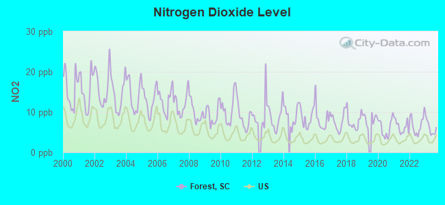
Nitrogen Dioxide (NO2) [ppb] level in 2023 was 6.08. This is about average. Closest monitor was 8.5 miles away from the city center.
| City: | 6.08 |
| U.S.: | 5.11 |
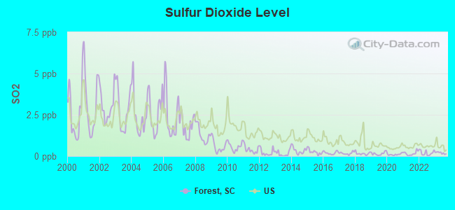
Sulfur Dioxide (SO2) [ppb] level in 2023 was 0.192. This is significantly better than average. Closest monitor was 8.5 miles away from the city center.
| City: | 0.192 |
| U.S.: | 1.515 |
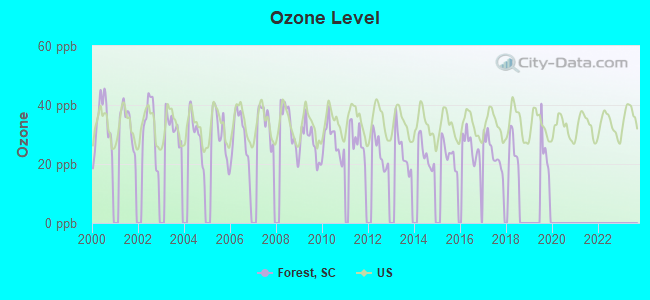
Ozone [ppb] level in 2017 was 23.8. This is better than average. Closest monitor was 10.6 miles away from the city center.
| City: | 23.8 |
| U.S.: | 33.3 |
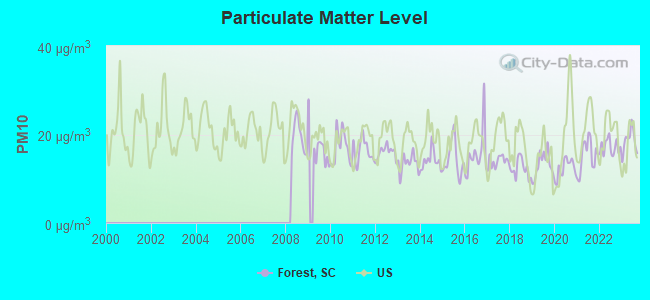
Particulate Matter (PM10) [µg/m3] level in 2023 was 18.5. This is about average. Closest monitor was 21.6 miles away from the city center.
| City: | 18.5 |
| U.S.: | 19.2 |
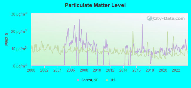
Particulate Matter (PM2.5) [µg/m3] level in 2023 was 10.8. This is worse than average. Closest monitor was 21.6 miles away from the city center.
| City: | 10.8 |
| U.S.: | 8.1 |
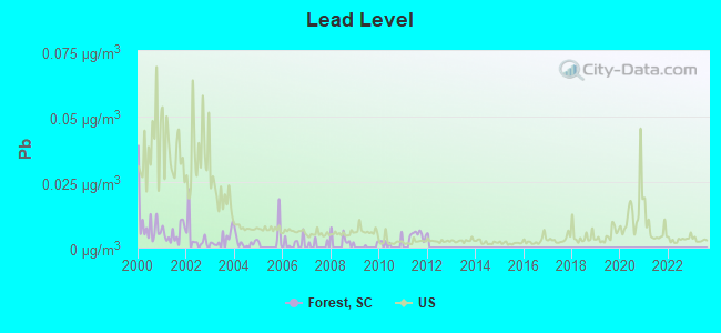
Lead (Pb) [µg/m3] level in 2011 was 0.00369. This is significantly better than average. Closest monitor was 20.4 miles away from the city center.
| City: | 0.00369 |
| U.S.: | 0.00931 |
Tornado activity:
Forest-area historical tornado activity is slightly below South Carolina state average. It is 6% smaller than the overall U.S. average.
On 3/27/1994, a category F3 (max. wind speeds 158-206 mph) tornado 19.2 miles away from the Forest place center injured 37 people and caused between $500,000 and $5,000,000 in damages.
On 5/27/1973, a category F3 tornado 24.0 miles away from the place center injured 40 people and caused between $500,000 and $5,000,000 in damages.
Earthquake activity:
Forest-area historical earthquake activity is significantly above South Carolina state average. It is 27% greater than the overall U.S. average.On 8/2/1974 at 08:52:09, a magnitude 4.9 (4.3 MB, 4.9 LG, Class: Light, Intensity: IV - V) earthquake occurred 79.7 miles away from Forest center
On 8/9/2020 at 12:07:37, a magnitude 5.1 (5.1 MW, Depth: 4.7 mi, Class: Moderate, Intensity: VI - VII) earthquake occurred 137.4 miles away from the city center
On 11/30/1973 at 07:48:41, a magnitude 4.7 (4.7 MB, 4.6 ML) earthquake occurred 88.1 miles away from the city center
On 8/23/2011 at 17:51:04, a magnitude 5.8 (5.8 MW, Depth: 3.7 mi) earthquake occurred 334.2 miles away from Forest center
On 4/29/2003 at 08:59:39, a magnitude 4.9 (4.4 MB, 4.6 MW, 4.9 LG) earthquake occurred 167.9 miles away from Forest center
On 7/27/1980 at 18:52:21, a magnitude 5.2 (5.1 MB, 4.7 MS, 5.0 UK, 5.2 UK) earthquake occurred 231.2 miles away from Forest center
Magnitude types: regional Lg-wave magnitude (LG), body-wave magnitude (MB), local magnitude (ML), surface-wave magnitude (MS), moment magnitude (MW)
Natural disasters:
The number of natural disasters in Pickens County (11) is smaller than the US average (15).Major Disasters (Presidential) Declared: 2
Emergencies Declared: 5
Causes of natural disasters: Hurricanes: 3, Storms: 3, Floods: 2, Tornadoes: 2, Winds: 2, Drought: 1, Ice Storm: 1, Tropical Storm: 1, Winter Storm: 1, Other: 1 (Note: some incidents may be assigned to more than one category).
Hospitals and medical centers near Forest:
- MANNA HEALTH AND REHAB OF PICKENS, LLC (Nursing Home, about 9 miles away; PICKENS, SC)
- REDEEMER HEALTH AND REHAB OF PICKENS, LLC (Nursing Home, about 9 miles away; PICKENS, SC)
- DHEC REGION 2 HOME HEALTH SVS (Home Health Center, about 10 miles away; PICKENS, SC)
- HOPE HEALTH AND REHAB OF MARIETTA, LLC (Nursing Home, about 14 miles away; MARIETTA, SC)
- STROUD MEM (Nursing Home, about 14 miles away; MARIETTA, SC)
- DSI EASLEY RENAL CENTER (Dialysis Facility, about 14 miles away; EASLEY, SC)
- BAPTIST EASLEY HOSPITAL Acute Care Hospitals (about 14 miles away; EASLEY, SC)
Colleges/universities with over 2000 students nearest to Forest:
- Furman University (about 18 miles; Greenville, SC; Full-time enrollment: 2,988)
- North Greenville University (about 22 miles; Tigerville, SC; FT enrollment: 2,341)
- Bob Jones University (about 24 miles; Greenville, SC; FT enrollment: 3,308)
- Clemson University (about 24 miles; Clemson, SC; FT enrollment: 20,131)
- Greenville Technical College (about 25 miles; Greenville, SC; FT enrollment: 9,859)
- Tri-County Technical College (about 26 miles; Pendleton, SC; FT enrollment: 5,174)
- Western Carolina University (about 29 miles; Cullowhee, NC; FT enrollment: 8,684)
Points of interest:
Notable locations in Forest: Camp McCall (A), Camp Rocky Bottom (B), Rocky Bottom Camp for the Blind (C), Camp Adger (D), Vineyards Fire Department (E), Pumpkintown Fire Department (F), Holly Springs Fire Department (G). Display/hide their locations on the map
Churches in Forest include: Rocky Bottom Baptist Church (A), Pleasant Grove Baptist Church (B), New Hope Baptist Church (C), Eastatoe Baptist Church (D), McKinney Chapel (E), Holly Springs Baptist Church (F), Antioch Baptist Church (G), Soapstone Church (H), Saluda Hill Church (I). Display/hide their locations on the map
Cemeteries: Eastatoe Cemetery (1), Lance Cemetery (2), Friendship Cemetery (3), Antioch Cemetery (4), Nimmons Cemetery (5), Rocky Bottom Cemetery (6), Pleasant Grove Cemetery (7). Display/hide their locations on the map
Reservoirs: Reedy Cove Creek Lake (A), Toxaway Lake (B), Harris Pond (C), Lake Jocassee (D), Big Rock Lake (E), Garren Lake (F), Lake Jocasse (G), Table Rock Cove (H). Display/hide their locations on the map
Streams, rivers, and creeks: Eastatoe Creek (A), Duck Creek (B), Winnie Branch (C), Willis Creek (D), Smith Creek (E), Side-of-Mountain Creek (F), Weaver Creek (G), Rocky Bottom Creek (H), Rock Creek (I). Display/hide their locations on the map
Parks in Forest include: Table Rock State Park (1), Table Rock State Park Historic District (2). Display/hide their locations on the map
| This place: | 2.5 people |
| South Carolina: | 2.5 people |
| This place: | 70.7% |
| Whole state: | 70.3% |
| This place: | 2.8% |
| Whole state: | 4.6% |
Likely homosexual households (counted as self-reported same-sex unmarried-partner households)
- Lesbian couples: 0.4% of all households
- Gay men: 0.2% of all households
| This place: | 9.8% |
| Whole state: | 14.1% |
| This place: | 3.9% |
| Whole state: | 6.5% |
For population 15 years and over in Forest:
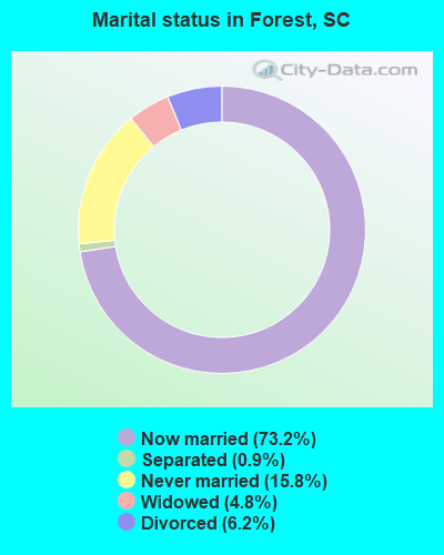
- Never married: 15.8%
- Now married: 73.2%
- Separated: 0.9%
- Widowed: 4.8%
- Divorced: 6.2%
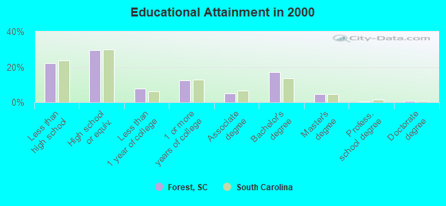
For population 25 years and over in Forest:
- High school or higher: 78.0%
- Bachelor's degree or higher: 23.3%
- Graduate or professional degree: 6.1%
- Unemployed: 3.2%
- Mean travel time to work (commute): 32.1 minutes
| Here: | 12.1 |
| South Carolina average: | 13.2 |
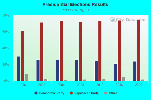
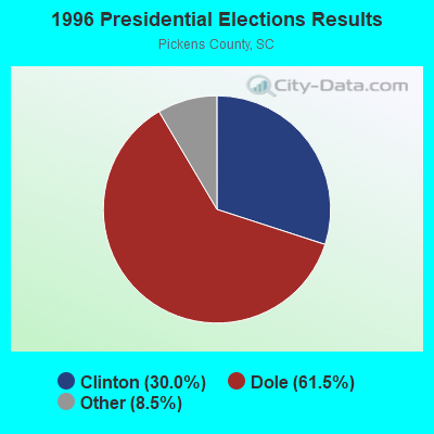
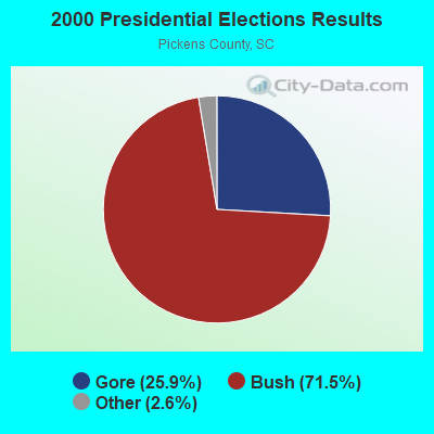
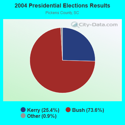
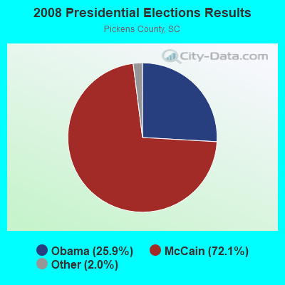
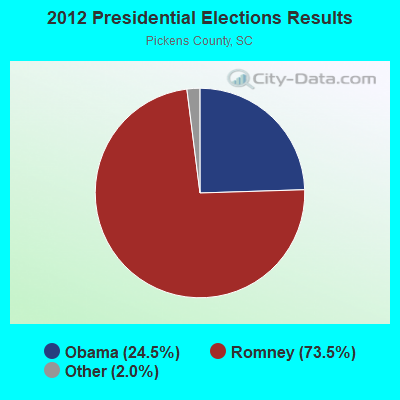
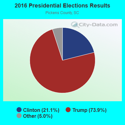
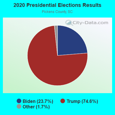
Graphs represent county-level data. Detailed 2008 Election Results
Religion statistics for Forest, SC (based on Pickens County data)
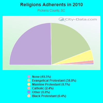
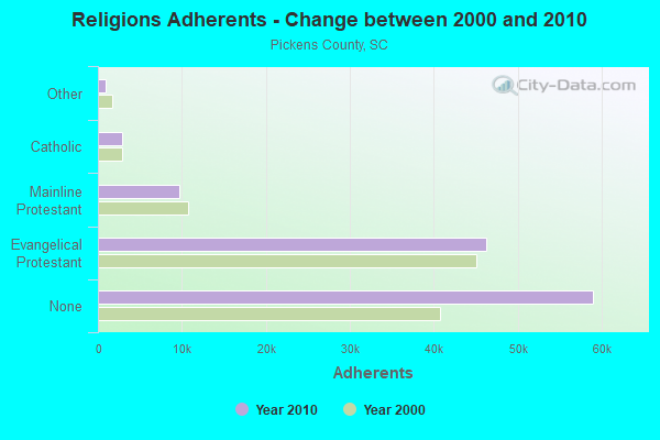
| Religion | Adherents | Congregations |
|---|---|---|
| Evangelical Protestant | 46,242 | 147 |
| Mainline Protestant | 9,640 | 32 |
| Catholic | 2,868 | 3 |
| Other | 963 | 7 |
| Black Protestant | 475 | 5 |
| None | 59,036 | - |
Food Environment Statistics:
| Pickens County: | 1.47 / 10,000 pop. |
| State: | 1.99 / 10,000 pop. |
| This county: | 0.09 / 10,000 pop. |
| South Carolina: | 0.15 / 10,000 pop. |
| Pickens County: | 0.78 / 10,000 pop. |
| South Carolina: | 0.85 / 10,000 pop. |
| Here: | 4.24 / 10,000 pop. |
| State: | 5.38 / 10,000 pop. |
| Pickens County: | 7.35 / 10,000 pop. |
| South Carolina: | 7.75 / 10,000 pop. |
| Here: | 9.3% |
| State: | 10.6% |
| Here: | 27.3% |
| South Carolina: | 29.4% |
| Pickens County: | 12.8% |
| State: | 13.4% |
Strongest AM radio stations in Forest:
- WLFJ (660 AM; daytime; 50 kW; GREENVILLE, SC; Owner: CLEAR CHANNEL BROADCASTING LICENSES, INC.)
- WCSZ (1070 AM; 50 kW; SANS SOUCI, SC; Owner: WHYZ RADIO, L.P.)
- WTBI (1540 AM; daytime; 10 kW; PICKENS, SC; Owner: TABERNACLE CHRISTIAN SCHOOLS)
- WGCR (720 AM; daytime; 10 kW; PISGAH FOREST, NC; Owner: ANCHOR BAPTIST BROADCASTING ASSOCIATION)
- WELP (1360 AM; 5 kW; EASLEY, SC)
- WFGW (1010 AM; 50 kW; BLACK MOUNTAIN, NC; Owner: BLUE RIDGE BROADCASTING CORP.)
- WGVL (1440 AM; 5 kW; GREENVILLE, SC; Owner: CAPSTAR TX LIMITED PARTNERSHIP)
- WDAB (1580 AM; 5 kW; TRAVELERS REST, SC; Owner: DABNEY-ADAMSON BROADCASTING, INC.)
- WKJV (1380 AM; 25 kW; ASHEVILLE, NC; Owner: INTERNATIONAL BAPTIST OUTREACH MISSIONS)
- WYRD (1330 AM; 5 kW; GREENVILLE, SC; Owner: ENTERCOM GREENVILLE LICENSE, LLC)
- WBCU (1460 AM; 50 kW; UNION, SC)
- WJFJ (1160 AM; 10 kW; TRYON, NC; Owner: COLUMBUS BROADCAST CORPORATION, INC.)
- WMUU (1260 AM; 5 kW; GREENVILLE, SC; Owner: WMUU, INC.)
Strongest FM radio stations in Forest:
- WESC-FM (92.5 FM; GREENVILLE, SC; Owner: CLEAR CHANNEL BROADCASTING LICENSES, INC.)
- W218AD (91.5 FM; BREVARD, NC; Owner: WESTERN NORTH CAROLINA PUBLIC RADIO)
- WMYI (102.5 FM; HENDERSONVILLE, NC; Owner: CAPSTAR TX LIMITED PARTNERSHIP)
- WKSF (99.9 FM; ASHEVILLE, NC; Owner: CAPSTAR TX LIMITED PARTNERSHIP)
- W220CD (91.9 FM; ENKA, NC; Owner: CALVARY CHAPEL OF TWIN FALLS, INC.)
- WMUU-FM (94.5 FM; GREENVILLE, SC; Owner: WMUU, INC.)
- WEPR (90.1 FM; GREENVILLE, SC; Owner: SOUTH CAROLINA EDUCATIONAL TV COMMISSION)
- WSPA-FM (98.9 FM; SPARTANBURG, SC; Owner: ENTERCOM GREENVILLE LICENSE, LLC)
- WFBC-FM (93.7 FM; GREENVILLE, SC; Owner: ENTERCOM GREENVILLE LICENSE, LLC)
- WLFJ-FM (89.3 FM; GREENVILLE, SC; Owner: RADIO TRAINING NETWORK, INC.)
- W237AR (95.3 FM; HAZELWOOD, ETC., NC; Owner: WESTERN NORTH CAROLINA PUBLIC RADIO)
- WTPT (93.3 FM; FOREST CITY, NC; Owner: UPSTATE BROADCASTING, LLC)
- WBZT-FM (96.7 FM; MAULDIN, SC; Owner: CLEAR CHANNEL BROADCASTING LICENSES, INC.)
- WJMZ-FM (107.3 FM; ANDERSON, SC; Owner: CXR HOLDINGS, INC.)
- WHLC (104.5 FM; HIGHLANDS, NC; Owner: CHARISMA RADIO CORP.)
- W269AY (101.7 FM; HIGHLANDS, NC; Owner: WESTERN NORTH CAROLINA PUBLIC RADIO)
- WMIT (106.9 FM; BLACK MOUNTAIN, NC; Owner: BLUE RIDGE BROADCASTING CORPORATION)
- WNCW (88.7 FM; SPINDALE, NC; Owner: ISOTHERMAL COMMUNITY COLLEGE)
- W277AL (103.3 FM; HIGHLANDS, NC; Owner: CHARISMA RADIO CORPORATION)
- WHZT (98.1 FM; SENECA, SC; Owner: CXR HOLDINGS, INC.)
TV broadcast stations around Forest:
- WHNS (Channel 21; ASHEVILLE, NC; Owner: MEREDITH CORPORATION)
- WYFF (Channel 4; GREENVILLE, SC; Owner: WYFF HEARST-ARGYLE TELEVISION, INC.)
- W50AB (Channel 50; HIAWASSEE, GA; Owner: GEORGIA PUBLIC TELECOMMUNICATIONS COMMISSION)
- WASV-TV (Channel 62; ASHEVILLE, NC; Owner: MEDIA GENERAL BROADCASTING OF SOUTH CAROLINA HOLDINGS, INC.)
- WBSC-TV (Channel 40; ANDERSON, SC; Owner: ANDERSON (WFBC-TV) LICENSEE, INC.)
- WSPA-TV (Channel 7; SPARTANBURG, SC; Owner: MEDIA GENERAL BROADCASTING OF SO. CAROLINA HOLDINGS, INC.)
- W22AC (Channel 22; HARTWELL & ROYSTON, GA; Owner: GEORGIA PUBLIC TELECOMMUNICATIONS COMMISSION)
- W68DM (Channel 68; BREVARD, NC; Owner: UNIVERSITY OF NORTH CAROLINA)
- WNTV (Channel 29; GREENVILLE, SC; Owner: SOUTH CAROLINA EDUCATIONAL TV COMMISSION)
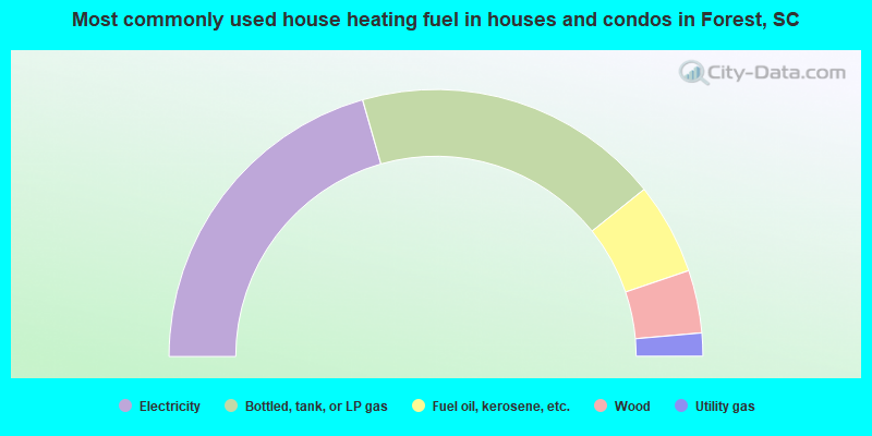
- 41.1%Electricity
- 37.3%Bottled, tank, or LP gas
- 11.1%Fuel oil, kerosene, etc.
- 7.6%Wood
- 2.8%Utility gas
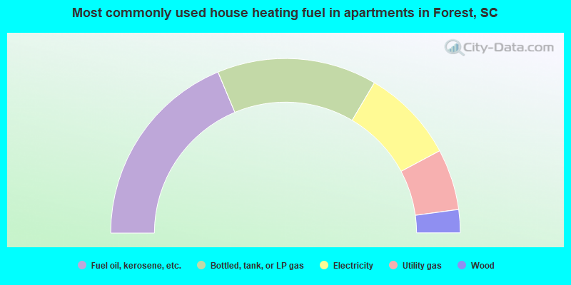
- 37.4%Fuel oil, kerosene, etc.
- 29.6%Bottled, tank, or LP gas
- 17.4%Electricity
- 11.3%Utility gas
- 4.3%Wood
Forest compared to South Carolina state average:
- Unemployed percentage significantly below state average.
- Black race population percentage significantly below state average.
- Hispanic race population percentage significantly below state average.
- Foreign-born population percentage significantly below state average.
- Renting percentage significantly below state average.
- Length of stay since moving in significantly above state average.
- Number of rooms per house significantly below state average.
- House age significantly below state average.