Fork, South Carolina
Submit your own pictures of this place and show them to the world
- OSM Map
- General Map
- Google Map
- MSN Map

| Males: 2,181 | |
| Females: 2,144 |
| Median resident age: | 41.6 years |
| South Carolina median age: | 35.4 years |
Zip code: 29689
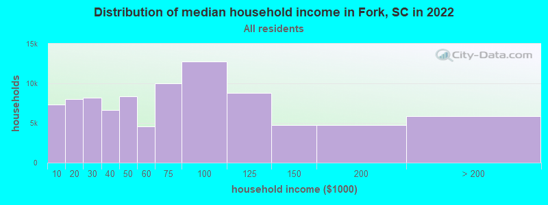
| Fork: | $66,443 |
| SC: | $64,115 |
Estimated per capita income in 2022: $40,279 (it was $21,264 in 2000)
Fork CCD income, earnings, and wages data
Estimated median house or condo value in 2022: $249,809 (it was $87,800 in 2000)
| Fork: | $249,809 |
| SC: | $254,600 |
Mean prices in 2022: all housing units: $270,967; detached houses: $301,070; townhouses or other attached units: $216,062; in 2-unit structures: $100,410; in 3-to-4-unit structures: $371,821; in 5-or-more-unit structures: $184,931; mobile homes: $78,481; occupied boats, rvs, vans, etc.: $71,913
Detailed information about poverty and poor residents in Fork, SC


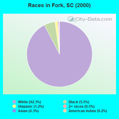
- 3,68792.3%White alone
- 2205.5%Black alone
- 471.2%Hispanic
- 200.5%Two or more races
- 120.3%Asian alone
- 60.2%American Indian alone
- 10.03%Native Hawaiian and Other
Pacific Islander alone
Races in Fork detailed stats: ancestries, foreign born residents, place of birth
 Recent articles from our blog. Our writers, many of them Ph.D. graduates or candidates, create easy-to-read articles on a wide variety of topics.
Current Local Time: EST time zone
Elevation: 100 feet
Land area: 36.3 square miles.
Population density: 119 people per square mile (very low).

| Fork CCD: | 0.6% ($525) |
| South Carolina: | 0.6% ($510) |
Nearest city with pop. 50,000+: Greenville, SC  (35.8 miles , pop. 56,002).
Nearest city with pop. 200,000+: Atlanta, GA (101.9 miles , pop. 416,474).
Nearest city with pop. 1,000,000+: Chicago, IL (569.0 miles , pop. 2,896,016).
Nearest cities:
), ), ), ), Latitude: 34.53 N, Longitude: 82.88 W
Area code commonly used in this area: 864

| Here: | 2.8% |
| South Carolina: | 3.1% |
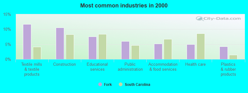
- Textile mills & textile products (11.7%)
- Construction (10.5%)
- Educational services (7.6%)
- Public administration (6.0%)
- Accommodation & food services (5.1%)
- Health care (4.9%)
- Plastics & rubber products (4.2%)
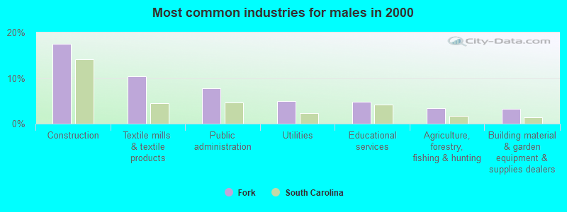
- Construction (17.5%)
- Textile mills & textile products (10.3%)
- Public administration (7.8%)
- Utilities (5.0%)
- Educational services (4.8%)
- Agriculture, forestry, fishing & hunting (3.4%)
- Building material & garden equipment & supplies dealers (3.3%)
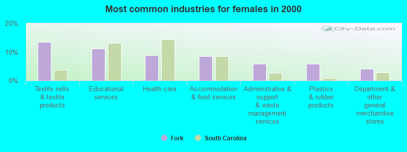
- Textile mills & textile products (13.5%)
- Educational services (11.1%)
- Health care (8.8%)
- Accommodation & food services (8.4%)
- Administrative & support & waste management services (5.9%)
- Plastics & rubber products (5.8%)
- Department & other general merchandise stores (4.0%)
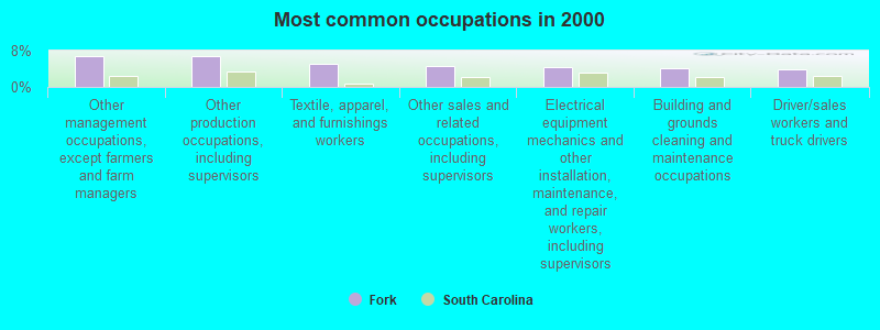
- Other management occupations, except farmers and farm managers (6.9%)
- Other production occupations, including supervisors (6.8%)
- Textile, apparel, and furnishings workers (5.1%)
- Other sales and related occupations, including supervisors (4.6%)
- Electrical equipment mechanics and other installation, maintenance, and repair workers, including supervisors (4.3%)
- Building and grounds cleaning and maintenance occupations (4.0%)
- Driver/sales workers and truck drivers (3.8%)
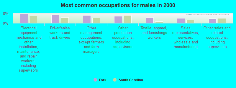
- Electrical equipment mechanics and other installation, maintenance, and repair workers, including supervisors (7.7%)
- Driver/sales workers and truck drivers (6.8%)
- Other management occupations, except farmers and farm managers (6.6%)
- Other production occupations, including supervisors (5.8%)
- Textile, apparel, and furnishings workers (4.9%)
- Sales representatives, services, wholesale and manufacturing (4.1%)
- Other sales and related occupations, including supervisors (3.9%)
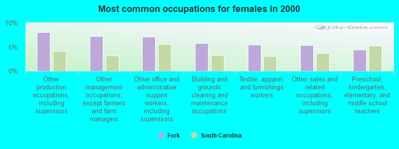
- Other production occupations, including supervisors (8.1%)
- Other management occupations, except farmers and farm managers (7.2%)
- Other office and administrative support workers, including supervisors (7.1%)
- Building and grounds cleaning and maintenance occupations (5.8%)
- Textile, apparel, and furnishings workers (5.5%)
- Other sales and related occupations, including supervisors (5.3%)
- Preschool, kindergarten, elementary, and middle school teachers (4.4%)
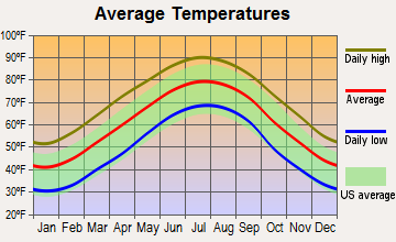
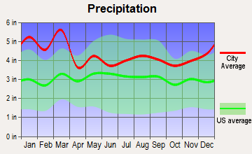
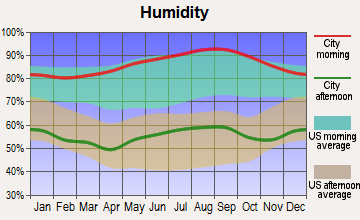
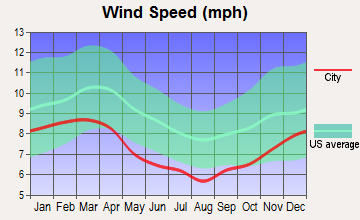
Average climate in Fork, South Carolina
Based on data reported by over 4,000 weather stations
Tornado activity:
Fork-area historical tornado activity is near South Carolina state average. It is 16% greater than the overall U.S. average.
On 4/8/1974, a category F3 (max. wind speeds 158-206 mph) tornado 10.5 miles away from the Fork place center caused between $500 and $5000 in damages.
On 3/31/1973, a category F4 (max. wind speeds 207-260 mph) tornado 35.6 miles away from the place center killed 7 people and injured 30 people and caused between $500,000 and $5,000,000 in damages.
Earthquake activity:
Fork-area historical earthquake activity is significantly above South Carolina state average. It is 24% greater than the overall U.S. average.On 8/2/1974 at 08:52:09, a magnitude 4.9 (4.3 MB, 4.9 LG, Class: Light, Intensity: IV - V) earthquake occurred 50.5 miles away from Fork center
On 8/9/2020 at 12:07:37, a magnitude 5.1 (5.1 MW, Depth: 4.7 mi, Class: Moderate, Intensity: VI - VII) earthquake occurred 168.3 miles away from Fork center
On 11/30/1973 at 07:48:41, a magnitude 4.7 (4.7 MB, 4.6 ML) earthquake occurred 107.2 miles away from the city center
On 4/29/2003 at 08:59:39, a magnitude 4.9 (4.4 MB, 4.6 MW, 4.9 LG) earthquake occurred 156.6 miles away from the city center
On 8/23/2011 at 17:51:04, a magnitude 5.8 (5.8 MW, Depth: 3.7 mi) earthquake occurred 361.8 miles away from the city center
On 7/27/1980 at 18:52:21, a magnitude 5.2 (5.1 MB, 4.7 MS, 5.0 UK, 5.2 UK) earthquake occurred 261.3 miles away from Fork center
Magnitude types: regional Lg-wave magnitude (LG), body-wave magnitude (MB), local magnitude (ML), surface-wave magnitude (MS), moment magnitude (MW)
Natural disasters:
The number of natural disasters in Anderson County (10) is smaller than the US average (15).Major Disasters (Presidential) Declared: 2
Emergencies Declared: 5
Causes of natural disasters: Floods: 3, Hurricanes: 3, Storms: 3, Drought: 1, Ice Storm: 1, Tornado: 1, Wind: 1, Winter Storm: 1, Other: 1 (Note: some incidents may be assigned to more than one category).
Hospitals and medical centers in Fork:
Other hospitals and medical centers near Fork:
- DHEC REGION 1 HOME HEALTH SERVICE (Home Health Center, about 8 miles away; ANDERSON, SC)
- FRESENIUS MEDICAL SERVICES OF PENDLETON (Dialysis Facility, about 10 miles away; PENDLETON, SC)
- SENECA HEALTH AND REHABILITATION CENTER (Nursing Home, about 11 miles away; SENECA, SC)
- FMC OCONEE DIALYSIS CLINIC INC (Dialysis Facility, about 12 miles away; SENECA, SC)
- CLEMSON AREA RETIREMENT CENTER (Nursing Home, about 12 miles away; CLEMSON, SC)
- HART CARE CENTER (Nursing Home, about 13 miles away; HARTWELL, GA)
- FELLOWSHIP HEALTH AND REHAB OF ANDERSON, LLC (Nursing Home, about 13 miles away; ANDERSON, SC)
Operable nuclear power plants near Fork:
- 12 miles: Oconee 1 and 2 in Seneca, SC.
- 12 miles: Oconee 3 in Seneca, SC.
Colleges/universities with over 2000 students nearest to Fork:
- Tri-County Technical College (about 10 miles; Pendleton, SC; Full-time enrollment: 5,174)
- Clemson University (about 11 miles; Clemson, SC; FT enrollment: 20,131)
- Anderson University (about 14 miles; Anderson, SC; FT enrollment: 2,510)
- Greenville Technical College (about 36 miles; Greenville, SC; FT enrollment: 9,859)
- Furman University (about 38 miles; Greenville, SC; FT enrollment: 2,988)
- Piedmont College (about 38 miles; Demorest, GA; FT enrollment: 2,251)
- Bob Jones University (about 39 miles; Greenville, SC; FT enrollment: 3,308)
Points of interest:
Notable locations in Fork: Anderson County Fire Department Double Springs (A), Anderson County Fire Protection Service Townville (B). Display/hide their locations on the map
Churches in Fork include: Shiloh Church (A), Mount Pleasant Church (B), Cedar Grove Church (C), Double Springs Baptist Church (D), Dickson Memorial United Methodist Church (E), New Prospect Church (F), Oakdale Church (G), Snow Hill Baptist Church (H), Smith Chapel (I). Display/hide their locations on the map
Cemeteries: Cedar Grove Methodist Cemetery (1), Smiths Chapel Cemetery (2), Snowhill Cemetery (3), Townville Cemetery (4). Display/hide their locations on the map
Creeks: Coneross Creek (A), Fair Play Creek (B), Wolf Creek (C), Hurricane Creek (D), East Prong Little Beaver Dam Creek (E), West Prong Little Beaver Dam Creek (F), Camp Creek (G). Display/hide their locations on the map
| This place: | 2.4 people |
| South Carolina: | 2.5 people |
| This place: | 63.3% |
| Whole state: | 70.3% |
| This place: | 5.2% |
| Whole state: | 4.6% |
Likely homosexual households (counted as self-reported same-sex unmarried-partner households)
- Lesbian couples: 0.5% of all households
- Gay men: 0.1% of all households
| This place: | 12.4% |
| Whole state: | 14.1% |
| This place: | 7.3% |
| Whole state: | 6.5% |
For population 15 years and over in Fork:
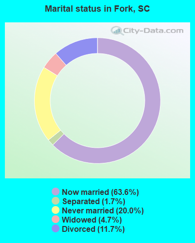
- Never married: 20.0%
- Now married: 63.6%
- Separated: 1.7%
- Widowed: 4.7%
- Divorced: 11.7%
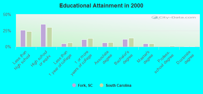
For population 25 years and over in Fork:
- High school or higher: 74.2%
- Bachelor's degree or higher: 16.6%
- Graduate or professional degree: 5.2%
- Unemployed: 2.4%
- Mean travel time to work (commute): 31.1 minutes
| Here: | 11.3 |
| South Carolina average: | 13.2 |
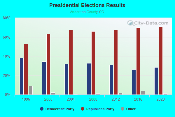
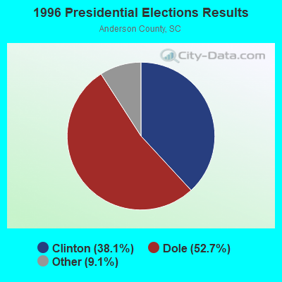
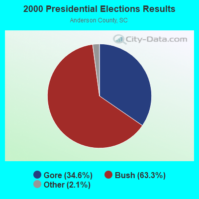

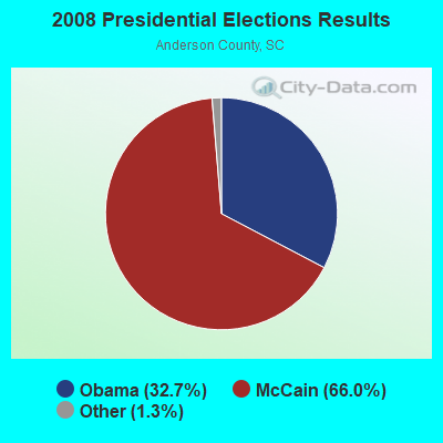
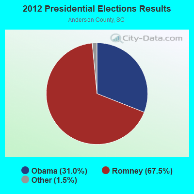
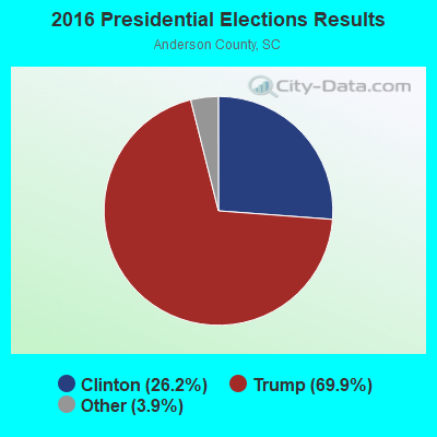

Graphs represent county-level data. Detailed 2008 Election Results
Religion statistics for Fork, SC (based on Anderson County data)
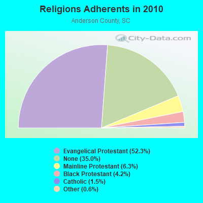
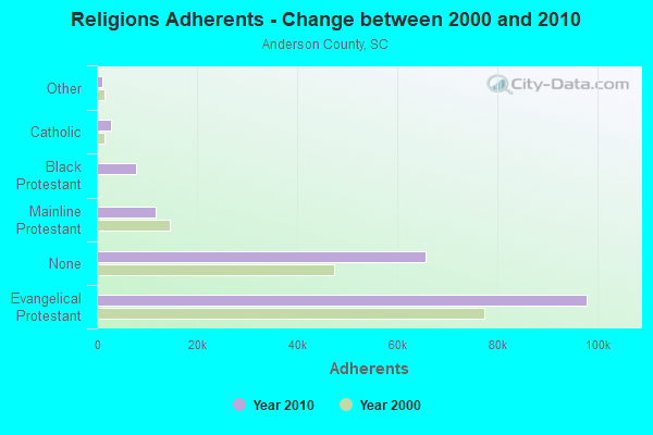
| Religion | Adherents | Congregations |
|---|---|---|
| Evangelical Protestant | 97,855 | 240 |
| Mainline Protestant | 11,775 | 59 |
| Black Protestant | 7,884 | 30 |
| Catholic | 2,851 | 2 |
| Other | 1,146 | 6 |
| Orthodox | 50 | 1 |
| None | 65,565 | - |
Food Environment Statistics:
| Anderson County: | 1.89 / 10,000 pop. |
| South Carolina: | 1.99 / 10,000 pop. |
| This county: | 0.17 / 10,000 pop. |
| South Carolina: | 0.15 / 10,000 pop. |
| This county: | 0.72 / 10,000 pop. |
| State: | 0.85 / 10,000 pop. |
| Anderson County: | 6.45 / 10,000 pop. |
| South Carolina: | 5.38 / 10,000 pop. |
| Here: | 6.78 / 10,000 pop. |
| State: | 7.75 / 10,000 pop. |
| Here: | 11.8% |
| South Carolina: | 10.6% |
| Anderson County: | 27.7% |
| South Carolina: | 29.4% |
| Here: | 12.9% |
| State: | 13.4% |
Strongest AM radio stations in Fork:
- WLFJ (660 AM; daytime; 50 kW; GREENVILLE, SC; Owner: CLEAR CHANNEL BROADCASTING LICENSES, INC.)
- WRIX (1020 AM; daytime; 10 kW; HOMELAND PARK, SC; Owner: AM 1020 INCORPORATED)
- WCSZ (1070 AM; 50 kW; SANS SOUCI, SC; Owner: WHYZ RADIO, L.P.)
- WANS (1280 AM; 5 kW; ANDERSON, SC; Owner: FM 103 INC.)
- WTBI (1540 AM; daytime; 10 kW; PICKENS, SC; Owner: TABERNACLE CHRISTIAN SCHOOLS)
- WCNN (680 AM; 50 kW; NORTH ATLANTA, GA; Owner: DICKEY BROADCASTING COMPANY)
- WSB (750 AM; 50 kW; ATLANTA, GA; Owner: CXR HOLDINGS, INC.)
- WFGW (1010 AM; 50 kW; BLACK MOUNTAIN, NC; Owner: BLUE RIDGE BROADCASTING CORP.)
- WBCU (1460 AM; 50 kW; UNION, SC)
- WGST (640 AM; 50 kW; ATLANTA, GA; Owner: CITICASTERS LICENSES, L.P.)
- WKLY (980 AM; 1 kW; HARTWELL, GA; Owner: JAMES E. HICKS & BILLIE F. HICKS, PARTNERS)
- WDUN (550 AM; 10 kW; GAINESVILLE, GA; Owner: JWJ PROPERTIRS, INC.)
- WELP (1360 AM; 5 kW; EASLEY, SC)
Strongest FM radio stations in Fork:
- WHZT (98.1 FM; SENECA, SC; Owner: CXR HOLDINGS, INC.)
- WJMZ-FM (107.3 FM; ANDERSON, SC; Owner: CXR HOLDINGS, INC.)
- WROQ (101.1 FM; ANDERSON, SC; Owner: OBC BROADCASTING, INC.)
- WESC-FM (92.5 FM; GREENVILLE, SC; Owner: CLEAR CHANNEL BROADCASTING LICENSES, INC.)
- WBTS (95.5 FM; ATHENS, GA; Owner: CXR HOLDINGS, INC.)
- WKSF (99.9 FM; ASHEVILLE, NC; Owner: CAPSTAR TX LIMITED PARTNERSHIP)
- WCCP-FM (104.9 FM; CLEMSON, SC; Owner: GOLDEN CORNERS BROADCASTING, INC.)
- WFQS (91.3 FM; FRANKLIN, NC; Owner: WESTERN NORTH CAROLINA PUBLIC RADIO)
- WSSL-FM (100.5 FM; GRAY COURT, SC; Owner: CAPSTAR TX LIMITED PARTNERSHIP)
- WRBN (104.1 FM; CLAYTON, GA; Owner: SUTTON RADIOCASTING CORPORATION)
- WMYI (102.5 FM; HENDERSONVILLE, NC; Owner: CAPSTAR TX LIMITED PARTNERSHIP)
- WMUU-FM (94.5 FM; GREENVILLE, SC; Owner: WMUU, INC.)
- WSPA-FM (98.9 FM; SPARTANBURG, SC; Owner: ENTERCOM GREENVILLE LICENSE, LLC)
- W237AR (95.3 FM; HAZELWOOD, ETC., NC; Owner: WESTERN NORTH CAROLINA PUBLIC RADIO)
- WEPR (90.1 FM; GREENVILLE, SC; Owner: SOUTH CAROLINA EDUCATIONAL TV COMMISSION)
- WFBC-FM (93.7 FM; GREENVILLE, SC; Owner: ENTERCOM GREENVILLE LICENSE, LLC)
- W220CD (91.9 FM; ENKA, NC; Owner: CALVARY CHAPEL OF TWIN FALLS, INC.)
- W269AY (101.7 FM; HIGHLANDS, NC; Owner: WESTERN NORTH CAROLINA PUBLIC RADIO)
- WLFJ-FM (89.3 FM; GREENVILLE, SC; Owner: RADIO TRAINING NETWORK, INC.)
- WHLC (104.5 FM; HIGHLANDS, NC; Owner: CHARISMA RADIO CORP.)
TV broadcast stations around Fork:
- W22AC (Channel 22; HARTWELL & ROYSTON, GA; Owner: GEORGIA PUBLIC TELECOMMUNICATIONS COMMISSION)
- W50AB (Channel 50; HIAWASSEE, GA; Owner: GEORGIA PUBLIC TELECOMMUNICATIONS COMMISSION)
- WHNS (Channel 21; ASHEVILLE, NC; Owner: MEREDITH CORPORATION)
- WBSC-TV (Channel 40; ANDERSON, SC; Owner: ANDERSON (WFBC-TV) LICENSEE, INC.)
- W50CL (Channel 50; ANDERSON, SC; Owner: TRINITY BROADCASTING NETWORK)
- WNEG-TV (Channel 32; TOCCOA, GA; Owner: MEDIA GENERAL BROADCASTING OF SO. CAROLINA HOLDINGS, INC.)
FCC Registered Antenna Towers:
5- Donna-Marie Stipo, 3725 Sc-41 (Lat: 34.297722 Lon: -79.269056), Type: 83.8, Structure height: 45033 m, Overall height: 79.2 m, Registrant: Tillman Infrastructure, LLC, Dmstipo@tillmaninfrastructure.Com, 27th Floor, New Y-ork, Phone: (212) 706-1677
- Donna-Marie Stipo, 3725 Sc-41 (Lat: 34.297722 Lon: -79.269056), Type: 83.8, Structure height: 45033 m, Overall height: 79.2 m, Registrant: Tillman Infrastructure, LLC, Dmstipo@tillmaninfrastructure.Com, 27th Floor, New Y-ork, Phone: (212) 706-1677
- Donna-Marie Stipo, 3725 Sc-41 (Lat: 34.297722 Lon: -79.269056), Type: 83.8, Structure height: 45033 m, Overall height: 79.2 m, Registrant: Tillman Infrastructure, LLC, Dmstipo@tillmaninfrastructure.Com, 27th Floor, New Y-ork, Phone: (212) 706-1677
- Donna-Marie Stipo, 2924 Old River Rd (Lat: 34.297722 Lon: -79.269056), Type: 82.3, Structure height: 45033 m, Overall height: 79.6 m, Registrant: Tillman Infrastructure, LLC, Dmstipo@tillmaninfrastructure.Com, 27th Floor, New Y-ork, Phone: (212) 706-1677
- Donna-Marie Stipo, 2924 Old River Rd (Lat: 34.297722 Lon: -79.269056), Type: 82.3, Structure height: 45033 m, Overall height: 79.6 m, Registrant: Tillman Infrastructure, LLC, Dmstipo@tillmaninfrastructure.Com, 27th Floor, New Y-ork, Phone: (212) 706-1677
FCC Registered Microwave Towers:
1- 8FL0819A, Sc-41 (Lat: 34.291278 Lon: -79.268500), Type: Ltower, Structure height: 59.4 m, Call Sign: WRXW744,
Assigned Frequencies: 10995.0 MHz, 10995.0 MHz, 10995.0 MHz, 10995.0 MHz, 10995.0 MHz, 10995.0 MHz, 10995.0 MHz, 10995.0 MHz, 10995.0 MHz, 10995.0 MHz... (+12 more), Grant Date: 07/06/2023, Expiration Date: 07/06/2033, Certifier: Jenny Knopf, Registrant: T-Mobile Usa, Inc., 12920 Se 38th Street, Bellevue, WA 98006, Phone: (425) 383-8401, Fax: (425) 383-4040, Email:
FCC Registered Amateur Radio Licenses:
5- Call Sign: KJ4IKR, Licensee ID: L01452289, Grant Date: 12/15/2008, Expiration Date: 12/15/2018, Cancellation Date: 03/22/2011, Certifier: Samuel D Smith, Registrant: Samuel D Smith, 2143 Proctor Rd, Fork, SC 29543
- Call Sign: K4KNJ, Previous Call Sign: KJ4IKR, Licensee ID: L01452289, Grant Date: 12/29/2020, Expiration Date: 03/22/2031, Certifier: Samuel D Smith, Registrant: Samuel D Smith, 2143 Proctor Rd, Fork, SC 29543
- Call Sign: KK4VTO, Licensee ID: L01829581, Grant Date: 12/10/2013, Expiration Date: 12/10/2023, Cancellation Date: 12/31/2013, Certifier: Samuel D Smith, Registrant: Greater Pee Dee Skywarn Group, 2143 Proctor Rd, Fork, SC 29543
- Call Sign: WX4PDE, Previous Call Sign: KK4VTO, Licensee ID: L01452289, Grant Date: 12/31/2013, Expiration Date: 12/31/2023, Cancellation Date: 10/13/2018, Certifier: Samuel D Smith, Registrant: Dillon County Amateur Radio Emergency Team, 2143 Proctor Rd, Fork, SC 29543
- Call Sign: K4DEC, Previous Call Sign: WX4PDE, Licensee ID: L01452289, Grant Date: 10/13/2018, Expiration Date: 10/13/2028, Certifier: Samuel D Smith, Registrant: Dillon County Amateur Radio Emergency Team, 2143 Proctor Rd, Fork, SC 29543
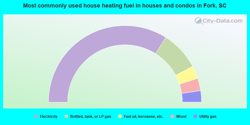
- 67.9%Electricity
- 16.6%Bottled, tank, or LP gas
- 5.4%Fuel oil, kerosene, etc.
- 5.3%Wood
- 4.8%Utility gas
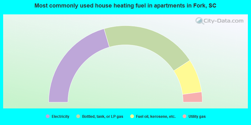
- 41.0%Electricity
- 40.6%Bottled, tank, or LP gas
- 14.1%Fuel oil, kerosene, etc.
- 4.3%Utility gas
Fork compared to South Carolina state average:
- Unemployed percentage significantly below state average.
- Black race population percentage significantly below state average.
- Hispanic race population percentage significantly below state average.
- Median age above state average.
- Foreign-born population percentage significantly below state average.
- Renting percentage significantly below state average.
- Length of stay since moving in significantly above state average.
- Number of rooms per house significantly below state average.
- House age significantly below state average.