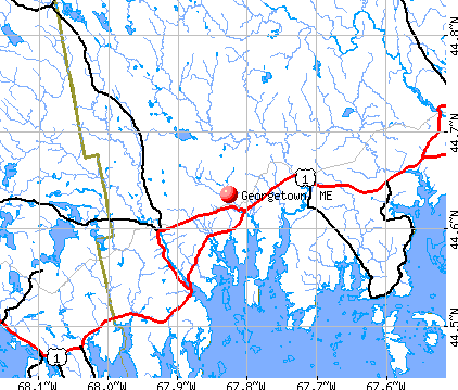
Georgetown, Maine

Georgetown: Georgetown Bowman's Landing Island
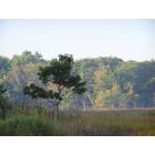
Georgetown: Georgetown Back River

Georgetown: Georgetown Boathouse Robinhood Cove

Georgetown: Pamaquid, Maine... "Spring in Maine by the ocean..."
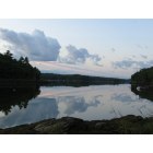
Georgetown: Robin Hood Cove After a storm, Georgetown Maine

Georgetown: Silence and fog in Booth Bay, Maine...

Georgetown: Silence and fog in Booth Bay, Maine...

Georgetown: As no other place in the U.S. is the beauty of Five Islands, Maine...

Georgetown: Simply - beautiful!

Georgetown: The fog is lifting... (Five Islands, ME)
- add
your
Submit your own pictures of this town and show them to the world
- OSM Map
- General Map
- Google Map
- MSN Map
Population change since 2000: +2.2%
 |
| Males: 522 | |
| Females: 520 |
| Median resident age: | 49.6 years |
| Maine median age: | 43.0 years |
Zip codes: 04548.
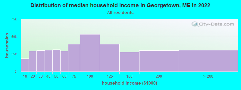
| Georgetown: | $90,200 |
| ME: | $69,543 |
Estimated per capita income in 2022: $51,491 (it was $24,709 in 2000)
Georgetown town income, earnings, and wages data
Estimated median house or condo value in 2022: $450,974 (it was $153,600 in 2000)
| Georgetown: | $450,974 |
| ME: | $290,600 |
Mean prices in 2022: all housing units: $359,191; detached houses: $377,995; townhouses or other attached units: $306,259; in 2-unit structures: $363,404; in 3-to-4-unit structures: $296,417; in 5-or-more-unit structures: $457,842; mobile homes: $167,878
Detailed information about poverty and poor residents in Georgetown, ME


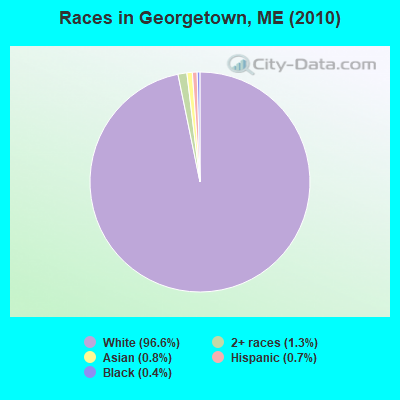
- 1,00796.6%White alone
- 141.3%Two or more races
- 80.8%Asian alone
- 70.7%Hispanic
- 40.4%Black alone
- 10.10%American Indian alone
- 10.10%Other race alone
Races in Georgetown detailed stats: ancestries, foreign born residents, place of birth
According to our research of Maine and other state lists, there was 1 registered sex offender living in Georgetown, Maine as of May 19, 2024.
The ratio of all residents to sex offenders in Georgetown is 1,042 to 1.
The ratio of registered sex offenders to all residents in this city is lower than the state average.
 Recent articles from our blog. Our writers, many of them Ph.D. graduates or candidates, create easy-to-read articles on a wide variety of topics.

 | Well, here goes. The start to our trek North to Maine, our new home-state. (395 replies) |
| Just wanted to say thank you to the people of Maine! (31 replies) |
| Retiring - Help, I've Narrowed It Down! (8 replies) |
| Where are the nice beaches near Portland? (10 replies) |
| Moving to Bath area (with children) (13 replies) |
| Arrowsic/Georgetown vs. Harpswell (10 replies) |
Latest news from Georgetown, ME collected exclusively by city-data.com from local newspapers, TV, and radio stations
Georgetown, ME City Guides:
Ancestries: English (30.4%), Irish (15.8%), French (10.2%), Scottish (10.2%), German (10.1%), United States (6.1%).
Current Local Time: EST time zone
Incorporated in 1716
Land area: 18.7 square miles.
Population density: 56 people per square mile (very low).
24 residents are foreign born (1.7% Europe, 0.3% North America).
| This town: | 2.4% |
| Maine: | 2.9% |
| Georgetown town: | 0.9% ($1,320) |
| Maine: | 1.5% ($1,417) |
Nearest city with pop. 50,000+: Portland, ME  (28.1 miles , pop. 64,249).
Nearest city with pop. 200,000+: Boston, MA (123.4 miles , pop. 589,141).
Nearest city with pop. 1,000,000+: Bronx, NY (294.2 miles , pop. 1,332,650).
Nearest cities:
), ), ), ), ), Latitude: 43.81 N, Longitude: 69.74 W
Area code commonly used in this area: 207

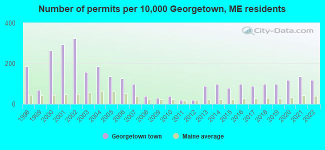
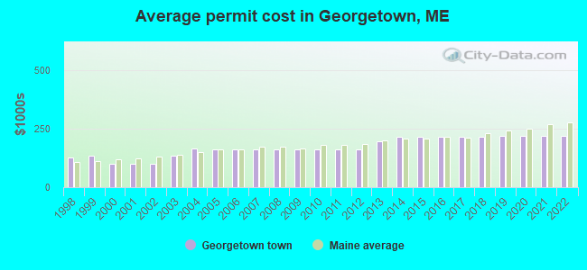
Single-family new house construction building permits:
- 2022: 12 buildings, average cost: $217,900
- 2021: 14 buildings, average cost: $217,900
- 2020: 12 buildings, average cost: $217,700
- 2019: 10 buildings, average cost: $219,000
- 2018: 10 buildings, average cost: $213,700
- 2017: 9 buildings, average cost: $213,700
- 2016: 10 buildings, average cost: $213,900
- 2015: 8 buildings, average cost: $213,300
- 2014: 10 buildings, average cost: $216,100
- 2013: 9 buildings, average cost: $193,800
- 2012: 2 buildings, average cost: $161,800
- 2011: 2 buildings, average cost: $161,800
- 2010: 4 buildings, average cost: $161,800
- 2009: 3 buildings, average cost: $161,800
- 2008: 4 buildings, average cost: $161,800
- 2007: 10 buildings, average cost: $161,800
- 2006: 13 buildings, average cost: $161,900
- 2005: 14 buildings, average cost: $161,200
- 2004: 19 buildings, average cost: $163,600
- 2003: 16 buildings, average cost: $132,800
- 2002: 33 buildings, average cost: $100,000
- 2001: 30 buildings, average cost: $100,000
- 2000: 27 buildings, average cost: $100,000
- 1999: 7 buildings, average cost: $135,700
- 1998: 19 buildings, average cost: $125,000
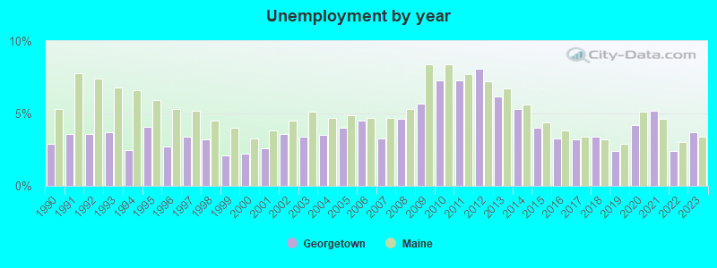
| Here: | 3.7% |
| Maine: | 3.4% |
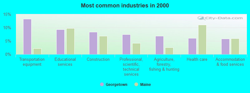
- Transportation equipment (13.3%)
- Educational services (9.4%)
- Construction (8.4%)
- Professional, scientific, technical services (7.4%)
- Agriculture, forestry, fishing & hunting (6.8%)
- Health care (6.0%)
- Accommodation & food services (5.8%)
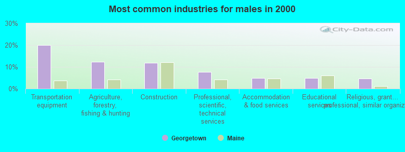
- Transportation equipment (20.1%)
- Agriculture, forestry, fishing & hunting (12.3%)
- Construction (12.0%)
- Professional, scientific, technical services (7.7%)
- Accommodation & food services (4.9%)
- Educational services (4.9%)
- Religious, grantmaking, civic, professional, similar organizations (4.6%)
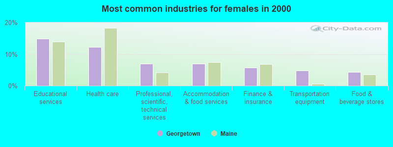
- Educational services (14.8%)
- Health care (12.2%)
- Professional, scientific, technical services (7.0%)
- Accommodation & food services (7.0%)
- Finance & insurance (5.7%)
- Transportation equipment (4.8%)
- Food & beverage stores (4.4%)
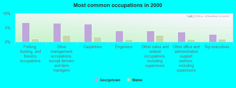
- Fishing, hunting, and forestry occupations (6.8%)
- Other management occupations, except farmers and farm managers (6.6%)
- Carpenters (6.2%)
- Engineers (3.9%)
- Other sales and related occupations, including supervisors (3.9%)
- Other office and administrative support workers, including supervisors (3.5%)
- Top executives (2.7%)
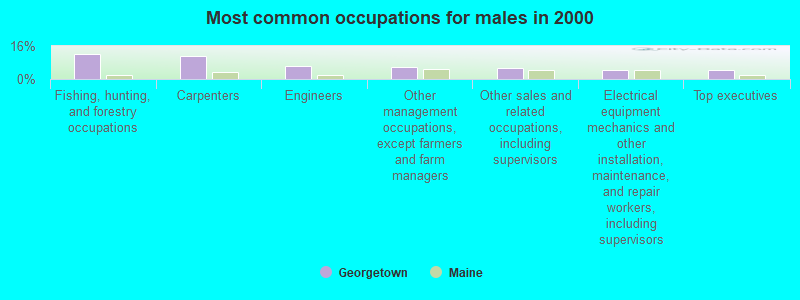
- Fishing, hunting, and forestry occupations (12.3%)
- Carpenters (11.3%)
- Engineers (6.3%)
- Other management occupations, except farmers and farm managers (5.6%)
- Other sales and related occupations, including supervisors (5.3%)
- Electrical equipment mechanics and other installation, maintenance, and repair workers, including supervisors (4.6%)
- Top executives (4.2%)
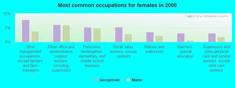
- Other management occupations, except farmers and farm managers (7.9%)
- Other office and administrative support workers, including supervisors (6.1%)
- Preschool, kindergarten, elementary, and middle school teachers (5.2%)
- Retail sales workers, except cashiers (5.2%)
- Waiters and waitresses (3.5%)
- Teachers, special education (3.1%)
- Supervisors and other personal care and service workers, except child care workers (3.1%)
Average climate in Georgetown, Maine
Based on data reported by over 4,000 weather stations


Earthquake activity:
Georgetown-area historical earthquake activity is significantly above Maine state average. It is 76% smaller than the overall U.S. average.On 10/16/2012 at 23:12:25, a magnitude 4.7 (4.7 ML, Depth: 10.0 mi, Class: Light, Intensity: IV - V) earthquake occurred 48.0 miles away from Georgetown center
On 4/20/2002 at 10:50:47, a magnitude 5.3 (5.3 ML, Depth: 3.0 mi, Class: Moderate, Intensity: VI - VII) earthquake occurred 202.1 miles away from the city center
On 1/19/1982 at 00:14:42, a magnitude 4.7 (4.5 MB, 4.7 MD, 4.5 LG) earthquake occurred 95.4 miles away from the city center
On 4/20/2002 at 10:50:47, a magnitude 5.2 (5.2 MB, 4.2 MS, 5.2 MW, 5.0 MW) earthquake occurred 202.7 miles away from Georgetown center
On 10/7/1983 at 10:18:46, a magnitude 5.3 (5.1 MB, 5.3 LG, 5.1 ML) earthquake occurred 229.4 miles away from the city center
On 2/26/1999 at 03:38:43, a magnitude 3.8 (3.8 LG, Depth: 2.0 mi, Class: Light, Intensity: II - III) earthquake occurred 47.6 miles away from the city center
Magnitude types: regional Lg-wave magnitude (LG), body-wave magnitude (MB), duration magnitude (MD), local magnitude (ML), surface-wave magnitude (MS), moment magnitude (MW)
Natural disasters:
The number of natural disasters in Sagadahoc County (19) is greater than the US average (15).Major Disasters (Presidential) Declared: 14
Emergencies Declared: 4
Causes of natural disasters: Floods: 12, Storms: 10, Winter Storms: 6, Hurricanes: 2, Snows: 2, Blizzard: 1, Ice Storm: 1, Snowfall: 1, Snowstorm: 1, Wind: 1, Other: 1 (Note: some incidents may be assigned to more than one category).

Hospitals and medical centers near Georgetown:
- ST ANDREWS HOME HEALTH (Home Health Center, about 6 miles away; BOOTHBAY HARBOR, ME)
- ST ANDREWS HOSPITAL (LINCOLN COUNTY HEALTHCARE) Critical Access Hospitals (about 6 miles away; BOOTHBAY HARBOR, ME)
- COASTAL DIALYSIS CENTER (Dialysis Facility, about 9 miles away; BATH, ME)
- WINSHIP GREEN NURSING CENTER (Nursing Home, about 10 miles away; BATH, ME)
- DIONNE COMMONS (Nursing Home, about 14 miles away; BRUNSWICK, ME)
- HORIZONS LIVING AND REHAB CENTER (Nursing Home, about 14 miles away; BRUNSWICK, ME)
- COMMUNITY HEALTH AND NURSING SERVICES (Home Health Center, about 14 miles away; BRUNSWICK, ME)
Colleges/universities with over 2000 students nearest to Georgetown:
- Southern Maine Community College (about 27 miles; South Portland, ME; Full-time enrollment: 4,666)
- University of Southern Maine (about 29 miles; Portland, ME; FT enrollment: 6,647)
- University of Maine at Augusta (about 37 miles; Augusta, ME; FT enrollment: 3,204)
- Saint Joseph's College of Maine (about 37 miles; Standish, ME; FT enrollment: 2,010)
- University of New England (about 41 miles; Biddeford, ME; FT enrollment: 4,539)
- University of Maine at Farmington (about 63 miles; Farmington, ME; FT enrollment: 2,036)
- University of New Hampshire-Main Campus (about 76 miles; Durham, NH; FT enrollment: 15,243)
Public elementary/middle school in Georgetown:
- GEORGETOWN CENTRAL SCHOOL (Students: 83, Location: 52 BAY PT RD 469, Grades: PK-6)
Points of interest:
Notable locations in Georgetown: Camp Sequin (A), Perkins Island Light Station (B), Robinhood Marine Center (C), Georgetown Volunteer Fire Department - Five Island Station (D), Georgetown Volunteer Fire Department Central Station (E). Display/hide their locations on the map
Church in Georgetown: Five Island Second Baptist Church (A). Display/hide its location on the map
Cemetery: Oak Cemetery (1). Display/hide its location on the map
Lakes and swamps: Charles Pond (A), Clareys Pond (B), Ice Pond (C), Traffton Meadow (D), Swett Marsh (E). Display/hide their locations on the map
Rivers and creeks: Back River (A), Little River (B), Bay Creek (C). Display/hide their locations on the map
Parks in Georgetown include: Josephine Newman Sanctuary (1), Reid State Park (2). Display/hide their locations on the map
Hotel: Greyhavens The (Sequinland Rd) (1). Display/hide its approximate location on the map
Drinking water stations with addresses in Georgetown and their reported violations in the past:
ROBINHOOD MARINE CENTER (Population served: 250, Groundwater):Past monitoring violations:MDOC ST PK - REID GRIFFITHS HEAD (Population served: 200, Groundwater):
- One regular monitoring violation
Past health violations:SAGADAHOC BAY CAMPGROUND (Population served: 93, Groundwater):Past monitoring violations:
- MCL, Monthly (TCR) - In AUG-2009, Contaminant: Coliform. Follow-up actions: St Public Notif requested (AUG-21-2009), St Formal NOV issued (AUG-21-2009), St Intentional no-action (SEP-09-2011), St Compliance achieved (SEP-09-2011)
- One routine major monitoring violation
Past monitoring violations:MACMAHAN ISLAND (Population served: 40, Surface water):
- 2 routine major monitoring violations
Past health violations:GREY HAVENS INN (Population served: 30, Groundwater):Past monitoring violations:
- MCL, Monthly (TCR) - In JUL-2006, Contaminant: Coliform. Follow-up actions: St Public Notif requested (AUG-09-2006), St Violation/Reminder Notice (AUG-09-2006), St Intentional no-action (SEP-09-2011), St Compliance achieved (SEP-09-2011)
- MCL, Monthly (TCR) - In AUG-2005, Contaminant: Coliform. Follow-up actions: St Public Notif requested (SEP-02-2005), St Violation/Reminder Notice (SEP-02-2005), St Public Notif received (2 times from DEC-09-2005 to DEC-09-2005), St Compliance achieved (SEP-05-2006)
- MCL, Monthly (TCR) - In JUL-2005, Contaminant: Coliform. Follow-up actions: St Public Notif requested (JUL-29-2005), St Violation/Reminder Notice (JUL-29-2005), St Public Notif received (2 times from AUG-10-2005 to AUG-10-2005), St Compliance achieved (SEP-05-2006)
- 4 routine major monitoring violations
Past health violations:Past monitoring violations:
- MCL, Acute (TCR) - In JUL-2006, Contaminant: Coliform. Follow-up actions: St Boil Water Order (JUL-28-2006), St Violation/Reminder Notice (JUL-28-2006), St Public Notif requested (JUL-28-2006), St Tech Assistance Visit (JUL-28-2006), St Public Notif received (AUG-07-2006), St Compliance achieved (SEP-09-2011)
- MCL, Monthly (TCR) - In SEP-2005, Contaminant: Coliform. Follow-up actions: St Public Notif requested (SEP-15-2005), St Violation/Reminder Notice (SEP-15-2005), St Public Notif received (2 times from NOV-16-2005 to NOV-16-2005), St Compliance achieved (MAR-05-2007)
- MCL, Monthly (TCR) - In JUL-2005, Contaminant: Coliform. Follow-up actions: St Public Notif requested (JUL-22-2005), St Violation/Reminder Notice (JUL-22-2005), St Public Notif received (2 times from AUG-03-2005 to AUG-03-2005), St Compliance achieved (MAR-05-2007)
- MCL, Monthly (TCR) - In JUN-2005, Contaminant: Coliform. Follow-up actions: St Public Notif requested (JUL-08-2005), St Violation/Reminder Notice (JUL-08-2005), St Public Notif received (2 times from JUL-21-2005 to JUL-21-2005), St Compliance achieved (MAR-05-2007)
- One routine major monitoring violation
- 2 regular monitoring violations
Drinking water stations with addresses in Georgetown that have no violations reported:
- MDOC ST PK - REID TODD POINT (Population served: 300, Primary Water Source Type: Groundwater)
| This town: | 2.2 people |
| Maine: | 2.3 people |
| This town: | 63.5% |
| Whole state: | 62.9% |
| This town: | 6.0% |
| Whole state: | 9.4% |
Likely homosexual households (counted as self-reported same-sex unmarried-partner households)
- Lesbian couples: 0.4% of all households
- Gay men: 0.4% of all households
| This town: | 6.8% |
| Whole state: | 10.9% |
| This town: | 3.4% |
| Whole state: | 4.1% |
For population 15 years and over in Georgetown:
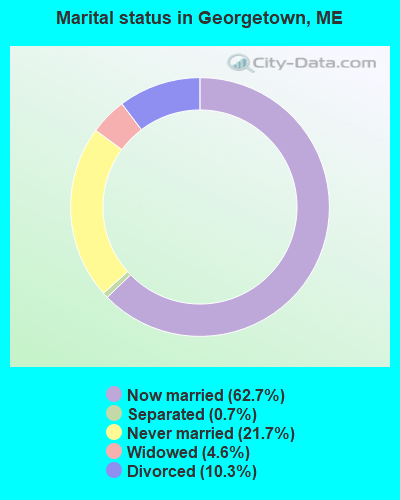
- Never married: 21.7%
- Now married: 62.7%
- Separated: 0.7%
- Widowed: 4.6%
- Divorced: 10.3%
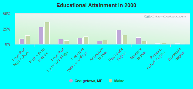
For population 25 years and over in Georgetown:
- High school or higher: 90.9%
- Bachelor's degree or higher: 37.8%
- Graduate or professional degree: 14.1%
- Unemployed: 1.5%
- Mean travel time to work (commute): 27.0 minutes
| Here: | 10.8 |
| Maine average: | 11.2 |
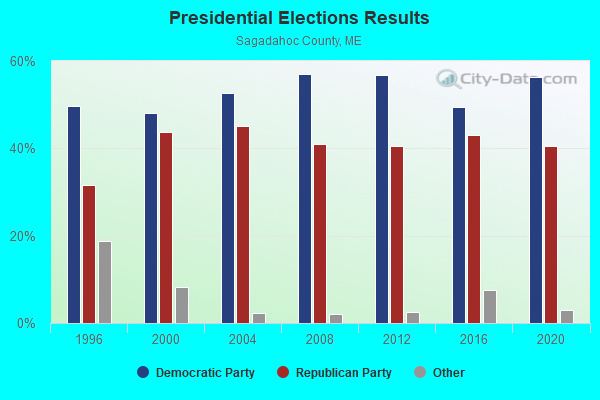
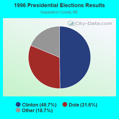
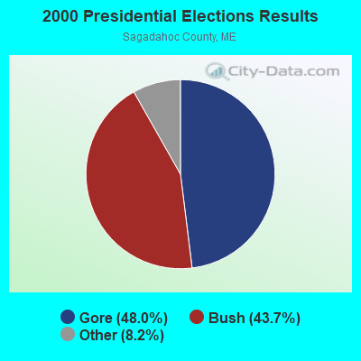
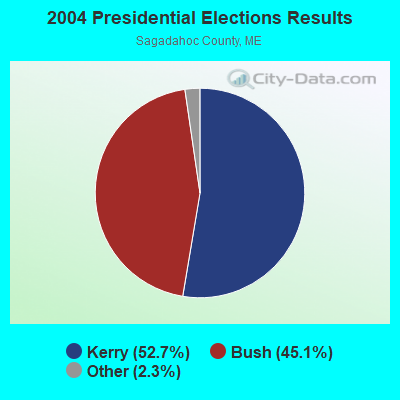

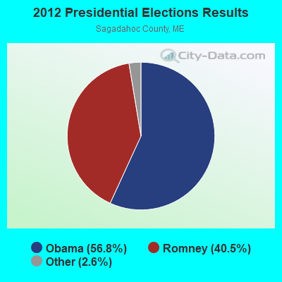

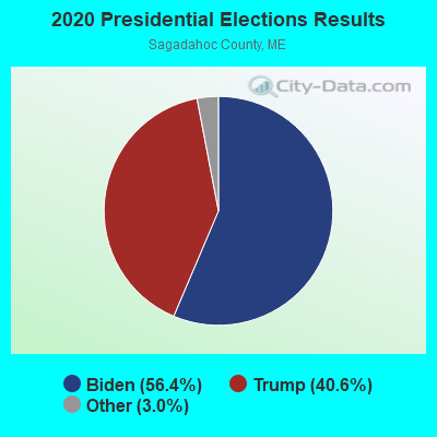
Graphs represent county-level data. Detailed 2008 Election Results
Religion statistics for Georgetown, ME (based on Sagadahoc County data)
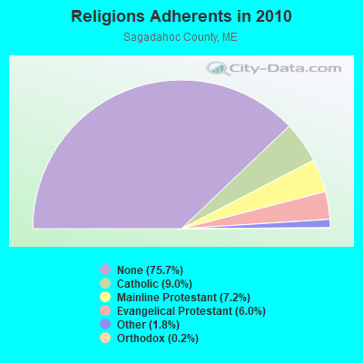
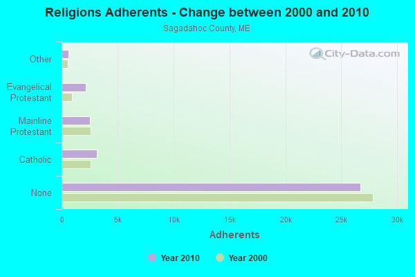
| Religion | Adherents | Congregations |
|---|---|---|
| Catholic | 3,177 | 3 |
| Mainline Protestant | 2,527 | 15 |
| Evangelical Protestant | 2,134 | 20 |
| Other | 646 | 2 |
| Orthodox | 88 | 1 |
| None | 26,721 | - |
Food Environment Statistics:
| Sagadahoc County: | 1.65 / 10,000 pop. |
| Maine: | 2.80 / 10,000 pop. |
| Here: | 1.93 / 10,000 pop. |
| Maine: | 2.20 / 10,000 pop. |
| Sagadahoc County: | 4.40 / 10,000 pop. |
| Maine: | 5.75 / 10,000 pop. |
| This county: | 10.18 / 10,000 pop. |
| Maine: | 11.02 / 10,000 pop. |
| Here: | 7.7% |
| State: | 8.2% |
| Sagadahoc County: | 26.5% |
| Maine: | 25.0% |
Strongest AM radio stations in Georgetown:
- WJTO (730 AM; 1 kW; BATH, ME; Owner: BLUE JEY BROADCASTING COMPANY)
- WGAN (560 AM; 5 kW; PORTLAND, ME; Owner: SAGA COMMUNICATIONS OF NEW ENGLAND, LLC)
- WMTW (870 AM; 10 kW; GORHAM, ME; Owner: RADIO PARTNERS OF MAINE, L.P.)
- WRKO (680 AM; 50 kW; BOSTON, MA; Owner: ENTERCOM BOSTON LICENSE, LLC)
- WZAN (970 AM; 5 kW; PORTLAND, ME; Owner: SAGA COMMUNICATIONS OF NEW ENGLAND, LLC)
- WJJB (900 AM; 1 kW; BRUNSWICK, ME; Owner: ATLANTIC COAST RADIO, LLC)
- WFAU (1280 AM; 5 kW; GARDINER, ME; Owner: CAPSTAR TX LIMITED PARTNERSHIP)
- WLOB (1310 AM; 5 kW; PORTLAND, ME; Owner: ATLANTIC COAST RADIO, LLC)
- WLAM (1470 AM; 5 kW; LEWISTON, ME; Owner: RADIO PARTNERS OF MAINE, L.P.)
- WEEI (850 AM; 50 kW; BOSTON, MA; Owner: ENTERCOM BOSTON LICENSE, LLC)
- WBZ (1030 AM; 50 kW; BOSTON, MA; Owner: INFINITY BROADCASTING OPERATIONS, INC.)
- WJAE (1440 AM; 5 kW; WESTBROOK, ME; Owner: ALTANTIC COAST RADIO, LLC)
- WTME (780 AM; 10 kW; RUMFORD, ME; Owner: MOUNTAIN VALLEY BROADCASTING, INC.)
Strongest FM radio stations in Georgetown:
- WCLZ (98.9 FM; BRUNSWICK, ME; Owner: CITADEL BROADCASTING COMPANY)
- WJJB-FM (95.5 FM; TOPSHAM, ME; Owner: ATLANTIC COAST RADIO, LLC)
- WBLM (102.9 FM; PORTLAND, ME; Owner: CITADEL BROADCASTING COMPANY)
- WMEA (90.1 FM; PORTLAND, ME; Owner: MAINE PUBLIC BROADCASTING CORPORATION)
- WPKQ (103.7 FM; NORTH CONWAY, NH; Owner: CITADEL BROADCASTING COMPANY)
- WTHT (107.5 FM; LEWISTON, ME; Owner: RADIO PARTNERS OF MAINE, L.P.)
- WHOM (94.9 FM; MT. WASHINGTON, NH; Owner: CITADEL BROADCASTING COMPANY)
- WYFP (91.9 FM; HARPSWELL, ME; Owner: BIBLE BROADCASTING NETWORK, INC.)
- WJBQ (97.9 FM; PORTLAND, ME; Owner: CITADEL BROADCASTING COMPANY)
- WCME (96.7 FM; BOOTHBAY HARBOR, ME; Owner: CAPSTAR TX LIMITED PARTNERSHIP)
- WBCI (105.9 FM; BATH, ME; Owner: BLOUNT COMMUNICATIONS, INC.)
- WMEP (90.5 FM; CAMDEN, ME; Owner: MAINE PUBLIC BROADCASTING CORP.)
- WQSS (102.5 FM; CAMDEN, ME; Owner: CLEAR CHANNEL BROADCASTING LICENSES, INC.)
- WCYI (93.9 FM; LEWISTON, ME; Owner: CITADEL BROADCASTING COMPANY)
- WMEK-FM (99.9 FM; AUBURN, ME; Owner: RADIO PARTNERS OF MAINE, L.P.)
- WMTW-FM (106.7 FM; NORTH WINDHAM, ME; Owner: RADIO PARTNERS OF MAINE, L.P.)
- WYNZ (100.9 FM; WESTBROOK, ME; Owner: SAGA COMMUNICATIONS OF NEW ENGLAND, LLC)
- WPOR (101.9 FM; PORTLAND, ME; Owner: SAGA COMMUNICATIONS OF NEW ENGLAND, LLC)
- WMCM (103.3 FM; ROCKLAND, ME; Owner: CLEAR CHANNEL BROADCASTING LICENSES, INC.)
- WMSJ (89.3 FM; FREEPORT, ME; Owner: DOWNEAST CHRISTIAN COMMUNICATIONS)
TV broadcast stations around Georgetown:
- WGME-TV (Channel 13; PORTLAND, ME; Owner: WGME LICENSEE, LLC)
- WMTW-TV (Channel 8; POLAND SPRING, ME; Owner: WMTW BROADCAST GROUP, LLC)
- WPFO (Channel 23; WATERVILLE, ME; Owner: CMCG PORTLAND LICENSE LLC)
- WPXT (Channel 51; PORTLAND, ME; Owner: HMW, INC.)
- WCSH (Channel 6; PORTLAND, ME; Owner: PACIFIC AND SOUTHERN COMPANY, INC.)
- WPME (Channel 35; LEWISTON, ME; Owner: KB PRIME MEDIA LLC)
- WCBB (Channel 10; AUGUSTA, ME; Owner: MAINE PUBLIC BROADCASTING CORP.)
- W32CA (Channel 32; PORTLAND, ME; Owner: NATIONAL MINORITY T.V., INC.)
Georgetown fatal accident list:
Apr 20, 2013 09:46 PM, Bay Point Road, Lat: 43.786428, Lon: -69.761017, Vehicles: 1, Persons: 1, Fatalities: 1, Drunk persons involved: 1
Sep 30, 2000 09:19 PM, Sr-127, Vehicles: 1, Persons: 1, Fatalities: 1, Drunk persons involved: 1
Jan 24, 1989 10:50 AM, 50355036, Vehicles: 1, Persons: 1, Fatalities: 1
May 29, 1988 01:00 AM, 50335034, Vehicles: 1, Persons: 2, Fatalities: 1, Drunk persons involved: 1
Oct 9, 1977 03:00 AM, Vehicles: 1, Persons: 2, Fatalities: 1, Drunk persons involved: 1
- National Bridge Inventory (NBI) Statistics
- 3Number of bridges
- 43ft / 12.6mTotal length
- 4,140Total average daily traffic
- 206Total average daily truck traffic
- 5,331Total future (year 2036) average daily traffic
FCC Registered Cell Phone Towers:
1- 60 North End Road (43819) (Lat: 43.829417 Lon: -69.718417), Type: Mtower, Structure height: 43 m, Overall height: 43.6 m, Call Sign: KNKA708
Assigned Frequencies: 869.040 MHz, 869.040 MHz, 869.040 MHz, 824.040 MHz, 824.040 MHz, 824.040 MHz, 890.010 MHz, 890.010 MHz, 890.010 MHz, 845.010 MHz, 845.010 MHz, 845.010 MHzGrant Date: 08/29/2017, Expiration Date: 10/01/2027, Certifier: Michael P GogginRegistrant: At&t Services, Inc., 208 S Akard St, 20f, Dallas, TX 75202, Phone: (855) 699-7073, Fax: (202) 457-3073, Email:
FCC Registered Broadcast Land Mobile Towers:
3- Municipal Bldg Georgetown Central School Bay Point Rd (Lat: 43.801194 Lon: -69.756167), Call Sign: KNDZ320, Licensee ID: L00058706,
Assigned Frequencies: 154.235 MHz, Grant Date: 10/04/2002, Expiration Date: 10/23/2012, Cancellation Date: 12/29/2012, Registrant: Georgetown, Town Of, Municipal Bldg Bay Point Rd, Georgetown, ME 04548, Phone: (207) 371-2052
- Reid State Park Sequinland Rd (Lat: 43.789528 Lon: -69.722000), Structure height: 4 m, Call Sign: WPDC203,
Assigned Frequencies: 159.240 MHz, Grant Date: 06/28/2023, Expiration Date: 09/01/2033, Registrant: State Of Maine, O.I.T., Radio Operations, 66 Industrial Drive, Augusta, ME 04333-0147, Phone: (207) 624-9990, Email:
- Lat: 43.800833 Lon: -69.756556, Call Sign: WQXX891,
Assigned Frequencies: 153.417 MHz, 159.675 MHz, Grant Date: 07/11/2016, Expiration Date: 07/11/2026, Certifier: Leslie Mcmahan, Registrant: New Wave Licensing Services, Inc., 818 Taneytown Rd, Gettysburg, PA 17325, Phone: (717) 334-0910, Email:
FCC Registered Maritime Coast & Aviation Ground Towers:
5- Seguin Island Lighthouse (Lat: 43.708417 Lon: -69.757833), Type: Building, Overall height: 18 m, Call Sign: WHD685, Licensee ID: L01008937,
Assigned Frequencies: 156.450 MHz, 156.800 MHz, 156.925 MHz, Grant Date: 04/27/2005, Expiration Date: 06/13/2015, Cancellation Date: 08/15/2015, Registrant: Friends Of Seguin Island Inc, Bath, ME 04530, Phone: (207) 443-4808
- Robinhood Rd (Lat: 44.852833 Lon: -69.734222), Type: Building, Overall height: 2 m, Call Sign: WHF938, Licensee ID: L00003806,
Assigned Frequencies: 156.450 MHz, 156.800 MHz, 156.575 MHz, Grant Date: 12/01/1998, Expiration Date: 12/29/2003, Cancellation Date: 02/29/2004, Registrant: Robinhood Marine Center Inc, Robinhood Rd, Robinhood, ME 04530
- End Of Route 127 On Wharf (Lat: 43.823972 Lon: -69.709222), Type: Building, Overall height: 7 m, Call Sign: WHU709,
Assigned Frequencies: 156.450 MHz, 156.800 MHz, 156.975 MHz, Grant Date: 12/02/1993, Expiration Date: 12/02/1998, Cancellation Date: 05/06/2001, Registrant: Georgetown Fishermans Coop, Georgetown, ME 04548
- 340 Robinhood Road (Lat: 44.852778 Lon: -69.734722), Type: Pole, Structure height: 24 m, Call Sign: WQDI265, Licensee ID: L00003806,
Assigned Frequencies: 156.450 MHz, 156.575 MHz, 156.800 MHz, Grant Date: 08/12/2015, Expiration Date: 09/01/2025, Certifier: Warren Harbison, Registrant: Robinhood Marine Center, Inc.
- 340 Robinhood Rd (Lat: 43.852889 Lon: -69.734194), Type: Pole, Structure height: 24 m, Call Sign: WQYX574,
Assigned Frequencies: 156.450 MHz, 156.575 MHz, 156.800 MHz, Grant Date: 02/22/2017, Expiration Date: 02/22/2027, Certifier: Jessica L Morrison, Registrant: Derecktor Maine LLC, 340 Robinhood Rd, Georgetown, ME 04548, Phone: (207) 371-2525, Fax: (207) 371-2899, Email:
FCC Registered Amateur Radio Licenses:
14 (See the full list of FCC Registered Amateur Radio Licenses in Georgetown)FAA Registered Aircraft:
4- Aircraft: PHILIP SHELTON DREAM AIRCRAFT TUNDR (Category: Amphibian, Seats: 4, Weight: Up to 12,499 Pounds), Engine: Reciprocating
N-Number: 133WV, N133WV, N-133WV, Serial Number: DR-TN-321FTN-06, Certificate Issue Date: 04/10/2012
Registrant (Individual): Philip J Shelton, 133 Williams Rd, Georgetown, ME 04548 - Aircraft: CESSNA 185 (Category: Land, Seats: 6, Weight: Up to 12,499 Pounds, Speed: 125 mph), Engine: CONT MOTOR I0-470 SERIES (260 HP) (Reciprocating)
N-Number: 481H, N481H, N-481H, Serial Number: 185-0116, Year manufactured: 1961, Airworthiness Date: 06/06/1961, Certificate Issue Date: 03/21/1995
Registrant (Individual): Stephen C Williams, 320 Robinhood Rd, Georgetown, ME 04548 - Aircraft: AMERICAN CHAMPION AIRCRAFT 7GCAA (Category: Land, Seats: 2, Weight: Up to 12,499 Pounds), Engine: LYCOMING 0-320 SERIES (180 HP) (Reciprocating)
N-Number: 571DM, N571DM, N-571DM, Serial Number: 464-2002, Year manufactured: 2002, Airworthiness Date: 07/08/2002, Certificate Issue Date: 04/17/2017
Registrant (Co-Owned): Stephen C Williams, 320 Robinhood Rd, Georgetown, ME 04548, Other Owners: Lisa R Reece, Jennifer Jorgensen - Aircraft: PIPER J3C-65 (Category: Land, Seats: 2, Weight: Up to 12,499 Pounds, Speed: 67 mph), Engine: CONT MOTOR C90 SERIES (95 HP) (Reciprocating)
N-Number: 98503, N98503, N-98503, Serial Number: 18707, Year manufactured: 1946, Airworthiness Date: 10/29/1996, Certificate Issue Date: 11/20/2000
Registrant (Corporation): Cub 503 Inc, 320 Robinhood Rd, Georgetown, ME 04548
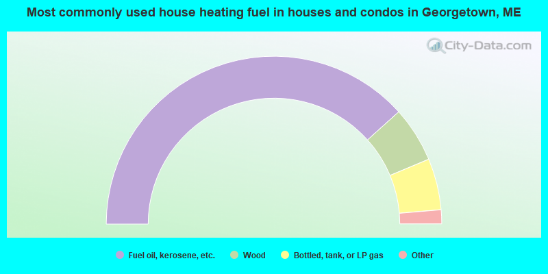
- 76.7%Fuel oil, kerosene, etc.
- 10.7%Wood
- 9.9%Bottled, tank, or LP gas
- 1.8%Electricity
- 0.9%Solar energy
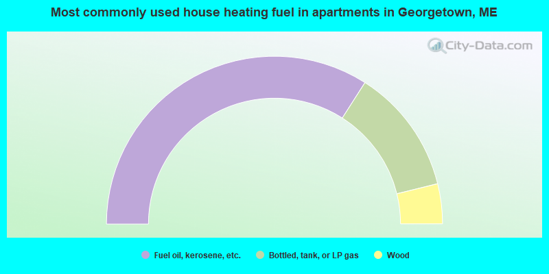
- 68.1%Fuel oil, kerosene, etc.
- 24.2%Bottled, tank, or LP gas
- 7.7%Wood
Georgetown compared to Maine state average:
- Median house value above state average.
- Unemployed percentage significantly below state average.
- Black race population percentage significantly below state average.
- Hispanic race population percentage significantly below state average.
- Median age above state average.
- Foreign-born population percentage below state average.
- Renting percentage below state average.
- Length of stay since moving in significantly above state average.
- Number of rooms per house significantly below state average.
- House age significantly below state average.
- Number of college students below state average.

|
Total of 8 patent applications in 2008-2024.