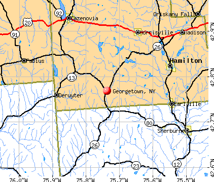
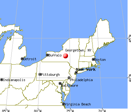
Georgetown, New York
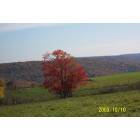
Georgetown: Fall in Georgetown
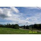
Georgetown: Blue sky forever!
Georgetown: Top of the Hill
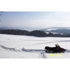
Georgetown: snow time
Georgetown: Dead Man's Hole
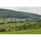
Georgetown: View from East Hill

Georgetown: We have life guards
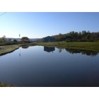
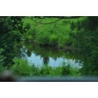
Georgetown: Clear water
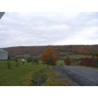
Georgetown: Fall Time
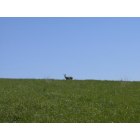
Georgetown: We have Deer
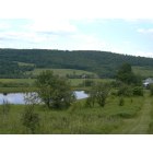
Georgetown: We have lots of ponds in Georgetown
- see
14
more - add
your


Submit your own pictures of this town and show them to the world
- OSM Map
- General Map
- Google Map
- MSN Map
Population change since 2000: +3.0%
 |
| Males: 572 | |
| Females: 402 |
| Median resident age: | 39.2 years |
| New York median age: | 40.7 years |
Zip codes: 13072.
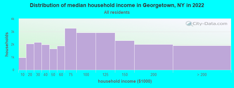
| Georgetown: | $66,118 |
| NY: | $79,557 |
Estimated per capita income in 2022: $22,727 (it was $11,825 in 2000)
Georgetown town income, earnings, and wages data
Estimated median house or condo value in 2022: $113,710 (it was $54,600 in 2000)
| Georgetown: | $113,710 |
| NY: | $400,400 |
Mean prices in 2022: all housing units: $228,996; detached houses: $251,711; townhouses or other attached units: $223,213; in 2-unit structures: $190,364; in 3-to-4-unit structures: $208,959; in 5-or-more-unit structures: $313,705; mobile homes: $82,599
Detailed information about poverty and poor residents in Georgetown, NY
Compare current foreclosures near Georgetown, NY:
| Photo | Address | Area | Beds / Baths | Price | Details |
|---|---|---|---|---|---|

|
#1
County Road 10
Norwich, NY 13815
|
1,572 sq. feet
|
1 baths 5 beds |
$15,900
|
show details |

|
#2
Old State Highway 23 # 23
South Plymouth, NY 13844
|
1,196 sq. feet
|
2 baths 3 beds |
$25,900
|
show details |

|
#3
Tracy Rd
Sherburne, NY 13460
|
- sq. feet
|
- baths 3 beds |
$39,900
|
show details |

|
#4
W Cottage Ln
De Ruyter, NY 13052
|
- sq. feet
|
3 baths 3 beds |
show details | |

|
#5
Center Rd
Madison, NY 13402
|
1,344 sq. feet
|
1 baths 2 beds |
show details | |

|
#6
County Road 16
Plymouth, NY 13832
|
1,600 sq. feet
|
1 baths 3 beds |
show details | |

|
#7
Swamp Rd
Fabius, NY 13063
|
1,711 sq. feet
|
1 baths 4 beds |
show details | |

|
#8
Poolville Rd
Hubbardsville, NY 13355
|
1,748 sq. feet
|
1 baths 5 beds |
show details | |

|
#9
Rexford Falls Rd
Sherburne, NY 13460
|
3,124 sq. feet
|
2 baths 4 beds |
show details | |

|
#10
Route 91
Tully, NY 13159
|
1,344 sq. feet
|
2 baths 3 beds |
show details |
| Photo | Address | Area | Beds / Baths | Price | Details |
|---|---|---|---|---|---|

|
#11
Rippleton Cross Rd
Cazenovia, NY 13035
|
835 sq. feet
|
1 baths 1 beds |
show details | |

|
#12
West Rd
Munnsville, NY 13409
|
1,386 sq. feet
|
2 baths 3 beds |
show details | |

|
#13
Ingalls Corners Rd
Canastota, NY 13032
|
874 sq. feet
|
1 baths 2 beds |
show details | |

|
#14
Reservoir Rd
Morrisville, NY 13408
|
1,808 sq. feet
|
2 baths 2 beds |
show details | |

|
#15
Brooklyn St
Eaton, NY 13334
|
2,986 sq. feet
|
1 baths 4 beds |
show details | |

|
#16
Collier Ln
Norwich, NY 13815
|
- sq. feet
|
- baths - beds |
show details | |

|
#17
State Route 80
Tully, NY 13159
|
- sq. feet
|
- baths - beds |
show details | |

|
#18
State Route 13
Truxton, NY 13158
|
- sq. feet
|
- baths - beds |
show details | |

|
#19
Valley Mills St
Munnsville, NY 13409
|
- sq. feet
|
- baths - beds |
show details | |

|
#20
Owahgena Rd
Cazenovia, NY 13035
|
- sq. feet
|
- baths - beds |
show details |
| Photo | Address | Area | Beds / Baths | Price | Details |
|---|---|---|---|---|---|

|
#21
Route 12
Madison, NY 13402
|
- sq. feet
|
- baths - beds |
show details | |

|
#22
Factory Dr
Cincinnatus, NY 13040
|
- sq. feet
|
- baths - beds |
show details | |

|
#23
Brown Rd
Munnsville, NY 13409
|
- sq. feet
|
- baths - beds |
show details | |

|
#24
Westcott Rd
Eaton, NY 13334
|
- sq. feet
|
- baths - beds |
show details | |

|
#25
Factory Dr
Cincinnatus, NY 13040
|
- sq. feet
|
- baths - beds |
show details | |

|
#26
County Road 16
Plymouth, NY 13832
|
- sq. feet
|
- baths - beds |
show details | |

|
#27
Cowles Settlement Rd
Truxton, NY 13158
|
- sq. feet
|
- baths - beds |
show details | |

|
#28
Cortland St Apt 210
De Ruyter, NY 13052
|
- sq. feet
|
- baths - beds |
show details | |

|
#29
Chamberlin Rd
Eaton, NY 13334
|
- sq. feet
|
- baths - beds |
show details | |

|
#30
Willowvale Rd
Morrisville, NY 13408
|
- sq. feet
|
- baths - beds |
show details |
| Photo | Address | Area | Beds / Baths | Price | Details |
|---|---|---|---|---|---|

|
#31
Lincklaen Center Rd
De Ruyter, NY 13052
|
- sq. feet
|
- baths - beds |
show details | |

|
#32
Route 13
De Ruyter, NY 13052
|
980 sq. feet
|
- baths - beds |
show details | |

|
#33
Route 13
De Ruyter, NY 13052
|
980 sq. feet
|
- baths - beds |
show details | |

|
#34
Oran Delphi Rd
Manlius, NY 13104
|
- sq. feet
|
- baths - beds |
show details | |

|
#35
S Hamilton Rd
Earlville, NY 13332
|
2,016 sq. feet
|
- baths - beds |
show details | |

|
#36
Payne St
Hamilton, NY 13346
|
- sq. feet
|
- baths - beds |
show details | |

|
#37
Airport Rd
Hamilton, NY 13346
|
- sq. feet
|
- baths - beds |
show details | |

|
#38
Roher Rd
Morrisville, NY 13408
|
- sq. feet
|
- baths - beds |
show details | |

|
#39
Roher Rd
Morrisville, NY 13408
|
980 sq. feet
|
- baths - beds |
show details | |

|
#40
Lake Moraine Rd
Hamilton, NY 13346
|
- sq. feet
|
- baths - beds |
show details |
| Photo | Address | Area | Beds / Baths | Price | Details |
|---|---|---|---|---|---|

|
#41
Maple Ave
Hamilton, NY 13346
|
- sq. feet
|
- baths - beds |
show details | |

|
#42
Center Rd
South Plymouth, NY 13844
|
- sq. feet
|
- baths - beds |
show details | |

|
Check over 1 million property listings on Foreclosure.com!
|
browse all offers | |||

- 83185.3%White alone
- 959.8%Black alone
- 333.4%Hispanic
- 60.6%Two or more races
- 40.4%American Indian alone
- 40.4%Asian alone
- 10.1%Other race alone

Races in Georgetown detailed stats: ancestries, foreign born residents, place of birth
According to our research of New York and other state lists, there were 6 registered sex offenders living in Georgetown, New York as of May 21, 2024.
The ratio of all residents to sex offenders in Georgetown is 162 to 1.
 Recent articles from our blog. Our writers, many of them Ph.D. graduates or candidates, create easy-to-read articles on a wide variety of topics.


Latest news from Georgetown, NY collected exclusively by city-data.com from local newspapers, TV, and radio stations
Ancestries: German (20.0%), English (19.8%), Irish (12.9%), United States (5.9%), French (4.3%), Italian (3.9%).
Current Local Time: EST time zone
Land area: 40.1 square miles.
Population density: 24 people per square mile (very low).
4 residents are foreign born
| This town: | 0.4% |
| New York: | 20.4% |
| Georgetown town: | 1.8% ($970) |
| New York: | 1.9% ($2,847) |
Nearest city with pop. 50,000+: Syracuse, NY  (27.0 miles , pop. 147,306).
Nearest city with pop. 200,000+: Rochester, NY (97.9 miles , pop. 219,773).
Nearest city with pop. 1,000,000+: Bronx, NY (165.4 miles , pop. 1,332,650).
Nearest cities:
), ), ), ), ), Latitude: 42.79 N, Longitude: 75.75 W
Area code: 315

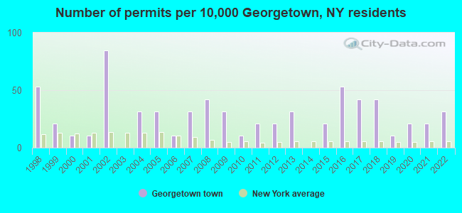
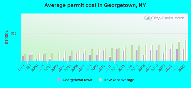
Single-family new house construction building permits:
- 2022: 3 buildings, average cost: $225,000
- 2021: 2 buildings, average cost: $225,000
- 2020: 2 buildings, average cost: $225,000
- 2019: 1 building, cost: $150,000
- 2018: 4 buildings, average cost: $212,500
- 2017: 4 buildings, average cost: $212,500
- 2016: 5 buildings, average cost: $111,000
- 2015: 2 buildings, average cost: $208,400
- 2013: 3 buildings, average cost: $183,300
- 2012: 2 buildings, average cost: $225,000
- 2011: 2 buildings, average cost: $87,500
- 2010: 1 building, cost: $200,000
- 2009: 3 buildings, average cost: $116,700
- 2008: 4 buildings, average cost: $118,800
- 2007: 3 buildings, average cost: $141,700
- 2006: 1 building, cost: $150,000
- 2005: 3 buildings, average cost: $91,700
- 2004: 3 buildings, average cost: $71,700
- 2002: 8 buildings, average cost: $47,000
- 2001: 1 building, cost: $110,000
- 2000: 1 building, cost: $40,000
- 1999: 2 buildings, average cost: $121,000
- 1998: 5 buildings, average cost: $97,100
| Here: | 4.4% |
| New York: | 4.4% |
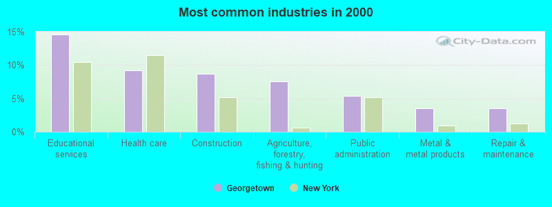
- Educational services (14.6%)
- Health care (9.2%)
- Construction (8.7%)
- Agriculture, forestry, fishing & hunting (7.6%)
- Public administration (5.4%)
- Metal & metal products (3.5%)
- Repair & maintenance (3.5%)
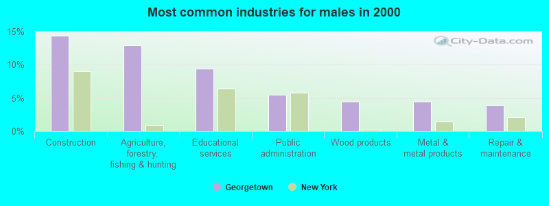
- Construction (14.4%)
- Agriculture, forestry, fishing & hunting (12.9%)
- Educational services (9.5%)
- Public administration (5.5%)
- Wood products (4.5%)
- Metal & metal products (4.5%)
- Repair & maintenance (4.0%)
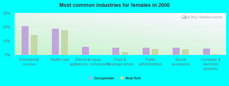
- Educational services (20.8%)
- Health care (19.0%)
- Electrical equipment, appliances, components (6.0%)
- Food & beverage stores (5.4%)
- Public administration (5.4%)
- Social assistance (5.4%)
- Computer & electronic products (4.8%)
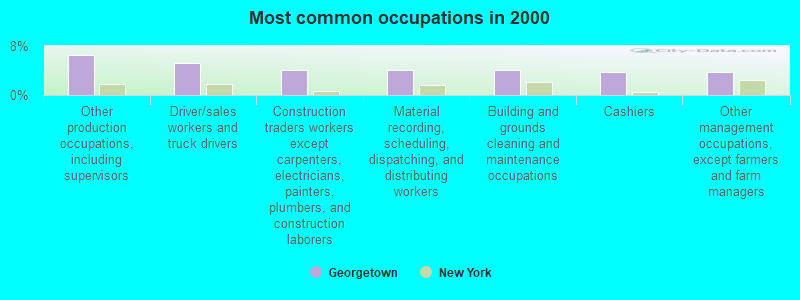
- Other production occupations, including supervisors (6.5%)
- Driver/sales workers and truck drivers (5.1%)
- Construction traders workers except carpenters, electricians, painters, plumbers, and construction laborers (4.1%)
- Material recording, scheduling, dispatching, and distributing workers (4.1%)
- Building and grounds cleaning and maintenance occupations (4.1%)
- Cashiers (3.8%)
- Other management occupations, except farmers and farm managers (3.8%)
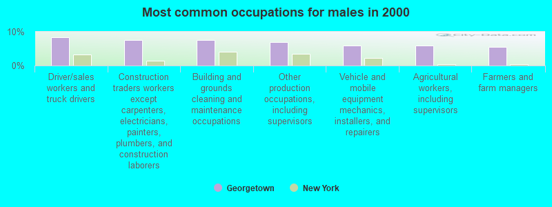
- Driver/sales workers and truck drivers (8.5%)
- Construction traders workers except carpenters, electricians, painters, plumbers, and construction laborers (7.5%)
- Building and grounds cleaning and maintenance occupations (7.5%)
- Other production occupations, including supervisors (7.0%)
- Vehicle and mobile equipment mechanics, installers, and repairers (6.0%)
- Agricultural workers, including supervisors (6.0%)
- Farmers and farm managers (5.5%)

- Cashiers (8.3%)
- Information and record clerks, except customer service representatives (7.7%)
- Nursing, psychiatric, and home health aides (6.5%)
- Other production occupations, including supervisors (6.0%)
- Other management occupations, except farmers and farm managers (5.4%)
- Health technologists and technicians (4.2%)
- Other teachers, instructors, education, training, and library occupations (4.2%)
Average climate in Georgetown, New York
Based on data reported by over 4,000 weather stations


(lower is better)
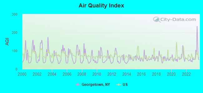
Air Quality Index (AQI) level in 2023 was 92.0. This is worse than average.
| City: | 92.0 |
| U.S.: | 72.6 |
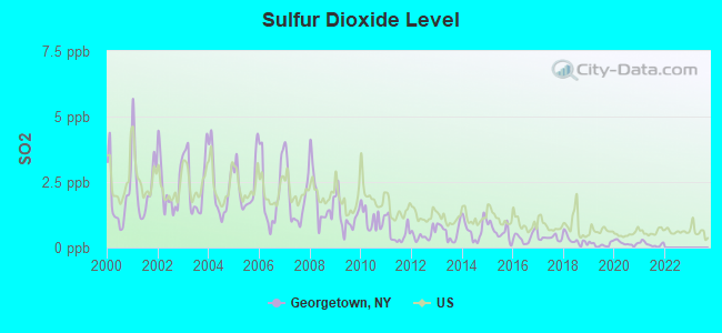
Sulfur Dioxide (SO2) [ppb] level in 2021 was 0.128. This is significantly better than average. Closest monitor was 4.4 miles away from the city center.
| City: | 0.128 |
| U.S.: | 1.515 |
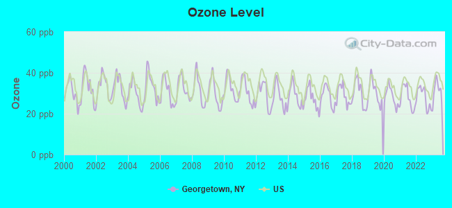
Ozone [ppb] level in 2023 was 30.9. This is about average. Closest monitor was 4.4 miles away from the city center.
| City: | 30.9 |
| U.S.: | 33.3 |
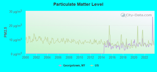
Particulate Matter (PM2.5) [µg/m3] level in 2023 was 9.42. This is about average. Closest monitor was 24.2 miles away from the city center.
| City: | 9.42 |
| U.S.: | 8.11 |
Tornado activity:
Georgetown-area historical tornado activity is slightly below New York state average. It is 71% smaller than the overall U.S. average.
On 9/18/1977, a category F2 (max. wind speeds 113-157 mph) tornado 3.7 miles away from the Georgetown town center injured one person and caused between $50,000 and $500,000 in damages.
On 5/2/1983, a category F3 (max. wind speeds 158-206 mph) tornado 35.7 miles away from the town center killed one person and caused between $500,000 and $5,000,000 in damages.
Earthquake activity:
Georgetown-area historical earthquake activity is significantly above New York state average. It is 67% smaller than the overall U.S. average.On 10/7/1983 at 10:18:46, a magnitude 5.3 (5.1 MB, 5.3 LG, 5.1 ML, Class: Moderate, Intensity: VI - VII) earthquake occurred 107.1 miles away from Georgetown center
On 4/20/2002 at 10:50:47, a magnitude 5.3 (5.3 ML, Depth: 3.0 mi) earthquake occurred 157.3 miles away from the city center
On 4/20/2002 at 10:50:47, a magnitude 5.2 (5.2 MB, 4.2 MS, 5.2 MW, 5.0 MW) earthquake occurred 155.3 miles away from the city center
On 8/23/2011 at 17:51:04, a magnitude 5.8 (5.8 MW, Depth: 3.7 mi) earthquake occurred 356.6 miles away from the city center
On 9/25/1998 at 19:52:52, a magnitude 5.2 (4.8 MB, 4.3 MS, 5.2 LG, 4.5 MW, Depth: 3.1 mi) earthquake occurred 254.7 miles away from Georgetown center
On 6/17/1991 at 08:53:16, a magnitude 4.1 (4.0 MB, 4.0 LG, Depth: 3.1 mi, Class: Light, Intensity: IV - V) earthquake occurred 55.4 miles away from the city center
Magnitude types: regional Lg-wave magnitude (LG), body-wave magnitude (MB), local magnitude (ML), surface-wave magnitude (MS), moment magnitude (MW)
Natural disasters:
The number of natural disasters in Madison County (21) is greater than the US average (15).Major Disasters (Presidential) Declared: 13
Emergencies Declared: 6
Causes of natural disasters: Storms: 11, Floods: 9, Hurricanes: 2, Snowstorms: 2, Tornadoes: 2, Winds: 2, Blizzard: 1, Heavy Rain: 1, Ice Storm: 1, Landslide: 1, Power Outage: 1, Tropical Storm: 1, Winter Storm: 1, Other: 2 (Note: some incidents may be assigned to more than one category).

Hospitals and medical centers near Georgetown:
Colleges/universities with over 2000 students nearest to Georgetown:
- Morrisville State College (about 11 miles; Morrisville, NY; Full-time enrollment: 2,823)
- Colgate University (about 11 miles; Hamilton, NY; FT enrollment: 3,094)
- Le Moyne College (about 25 miles; Syracuse, NY; FT enrollment: 3,041)
- SUNY College of Environmental Science and Forestry (about 27 miles; Syracuse, NY; FT enrollment: 2,044)
- Syracuse University (about 27 miles; Syracuse, NY; FT enrollment: 20,717)
- SUNY College at Cortland (about 27 miles; Cortland, NY; FT enrollment: 6,838)
- Onondaga Community College (about 28 miles; Syracuse, NY; FT enrollment: 8,920)
Points of interest:
Notable location: Georgetown Station (A). Display/hide its location on the map
Cemeteries: Niles Cemetery (1), Allard Cemetery (2), Hawk Cemetery (3), Hillside Cemetery (4). Display/hide their locations on the map
Lake: Torpy Pond (A). Display/hide its location on the map
Streams, rivers, and creeks: Otselic Creek (A), Muller Brook (B). Display/hide their locations on the map
| This town: | 2.7 people |
| New York: | 2.6 people |
| This town: | 68.8% |
| Whole state: | 63.5% |
| This town: | 8.2% |
| Whole state: | 6.8% |
Likely homosexual households (counted as self-reported same-sex unmarried-partner households)
- Lesbian couples: 1.0% of all households
- Gay men: 0.0% of all households
| This town: | 11.4% |
| Whole state: | 14.6% |
| This town: | 1.9% |
| Whole state: | 7.4% |
243 people in halfway houses in 2000
For population 15 years and over in Georgetown:
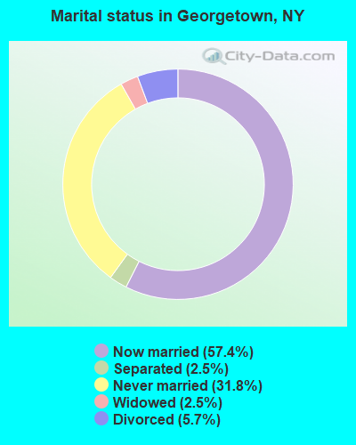
- Never married: 31.8%
- Now married: 57.4%
- Separated: 2.5%
- Widowed: 2.5%
- Divorced: 5.7%
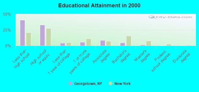
For population 25 years and over in Georgetown:
- High school or higher: 59.3%
- Bachelor's degree or higher: 7.3%
- Graduate or professional degree: 2.3%
- Unemployed: 5.1%
- Mean travel time to work (commute): 33.9 minutes
| Here: | 12.5 |
| New York average: | 14.2 |
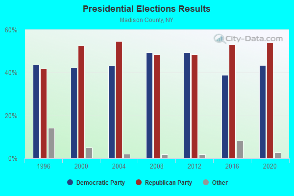
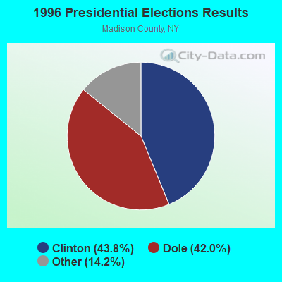
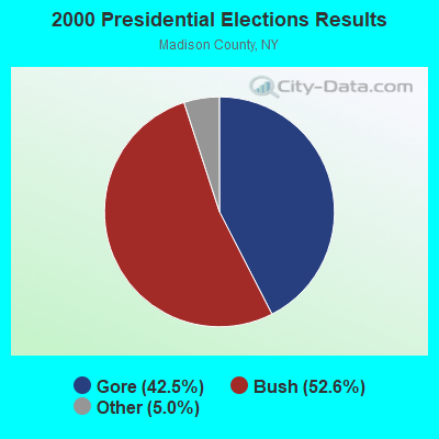
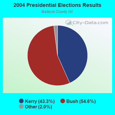
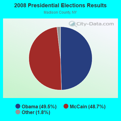
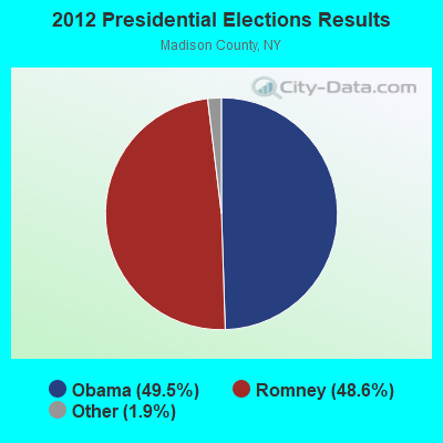
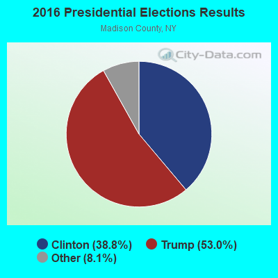
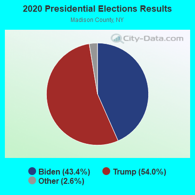
Graphs represent county-level data. Detailed 2008 Election Results
Religion statistics for Georgetown, NY (based on Madison County data)
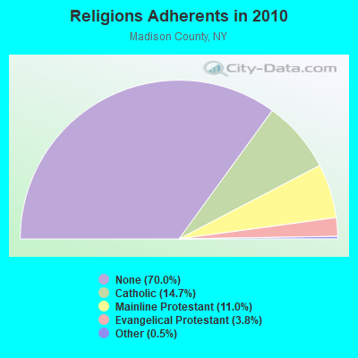
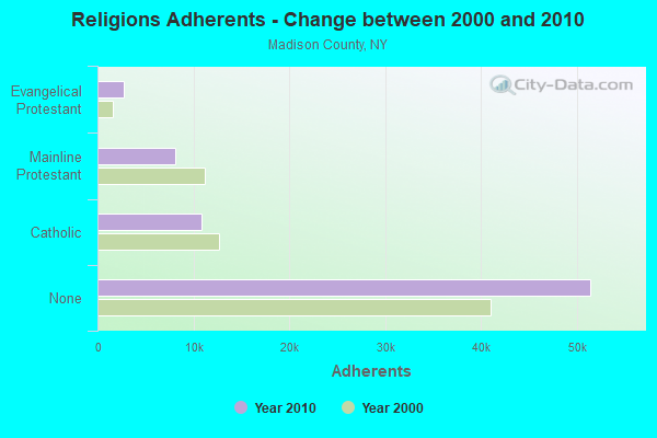
| Religion | Adherents | Congregations |
|---|---|---|
| Catholic | 10,810 | 9 |
| Mainline Protestant | 8,060 | 45 |
| Evangelical Protestant | 2,780 | 28 |
| Other | 358 | 6 |
| None | 51,434 | - |
Food Environment Statistics:
| Here: | 2.15 / 10,000 pop. |
| State: | 4.13 / 10,000 pop. |
| This county: | 0.14 / 10,000 pop. |
| State: | 0.06 / 10,000 pop. |
| Madison County: | 0.57 / 10,000 pop. |
| New York: | 0.92 / 10,000 pop. |
| Here: | 2.72 / 10,000 pop. |
| New York: | 1.68 / 10,000 pop. |
| This county: | 8.30 / 10,000 pop. |
| State: | 8.82 / 10,000 pop. |
| Madison County: | 7.4% |
| New York: | 8.2% |
| Here: | 26.6% |
| New York: | 23.8% |
| Here: | 15.9% |
| New York: | 15.6% |
Strongest AM radio stations in Georgetown:
- WSYR (570 AM; 5 kW; SYRACUSE, NY; Owner: CLEAR CHANNEL BROADCASTING LICENSES, INC.)
- WHEN (620 AM; 5 kW; SYRACUSE, NY; Owner: CLEAR CHANNEL BROADCASTING LICENSES, INC.)
- WGY (810 AM; 50 kW; SCHENECTADY, NY; Owner: CLEAR CHANNEL BROADCASTING LICENSES, INC.)
- WNSS (1260 AM; 5 kW; SYRACUSE, NY; Owner: CITADEL BROADCASTING COMPANY)
- WIBX (950 AM; 5 kW; UTICA, NY; Owner: REGENT LICENSEE OF UTICA/ROME, INC.)
- WTLB (1310 AM; 5 kW; UTICA, NY; Owner: GALAXY COMMUNICATIONS, L.P.)
- WHAM (1180 AM; 50 kW; ROCHESTER, NY; Owner: CITICASTERS LICENSES, L.P.)
- WRUN (1150 AM; 5 kW; UTICA, NY)
- WHCU (870 AM; 5 kW; ITHACA, NY; Owner: EAGLE BROADCASTING COMPANY, INC.)
- WSIV (1540 AM; 2 kW; E. SYRACUSE, NY; Owner: CRAM COMMUNICATIONS LLC)
- WPTR (1540 AM; 50 kW; ALBANY, NY; Owner: KIMTRON, INC.)
- WDCW (1390 AM; 5 kW; SYRACUSE, NY; Owner: KIMTRON, INC.)
- WINR (680 AM; 5 kW; BINGHAMTON, NY; Owner: CLEVELAND RADIO LICENSES, LLC)
Strongest FM radio stations in Georgetown:
- WWDG (105.1 FM; DERUYTER, NY; Owner: CLEAR CHANNEL BROADCASTING LICENSES, INC.)
- WCNY-FM (91.3 FM; SYRACUSE, NY; Owner: THE PUB. B/C COUNC. OF CEN. NY, INC.)
- WMCR-FM (106.3 FM; ONEIDA, NY; Owner: WARREN BROADCASTING CO. INC.)
- WNTQ (93.1 FM; SYRACUSE, NY; Owner: CITADEL BROADCASTING COMPANY)
- WXXE (90.5 FM; FENNER, NY; Owner: SYRACUSE COMMUNITY RADIO, INC.)
- WYYY (94.5 FM; SYRACUSE, NY; Owner: CLEAR CHANNEL BROADCASTING LICENSES, INC.)
- WSKS (97.9 FM; WHITESBORO, NY; Owner: CLEAR CHANNEL BROADCASTING LICENSES, INC.)
- WMHR (102.9 FM; SYRACUSE, NY; Owner: MARS HILL BROADCASTING CO., INC.)
- WKXZ (93.9 FM; NORWICH, NY; Owner: BANJO COMMUNICATIONS GROUP, INC)
- WBKT (95.3 FM; NORWICH, NY; Owner: BANJO COMMUNICATIONS GROUP, INC)
- WRBY (102.5 FM; ROME, NY; Owner: CLEAR CHANNEL BROADCASTING LICENSES, INC.)
- WIII (99.9 FM; CORTLAND, NY; Owner: CITADEL BROADCASTING COMPANY)
- W278AH (103.5 FM; SYRACUSE, JAMESVILLE, NY; Owner: CALVARY CHAPEL OF THE FINGER LAKES, INC.)
- WWHT (107.9 FM; SYRACUSE, NY; Owner: CLEAR CHANNEL BROADCASTING LICENSES, INC.)
- W251AK (98.1 FM; NEDROW, NY; Owner: PATHWAY COMMUNITY RADIO, INC.)
- W257BE (99.3 FM; HAMILTON, NY; Owner: BANJO COMMUNICATIONS GROUP, INC)
- WXHC (101.5 FM; HOMER, NY; Owner: EVES BROADCASTING, INC.)
- WPHR (106.9 FM; AUBURN, NY; Owner: CLEAR CHANNEL BROADCASTING LICENSES, INC.)
- WFRG-FM (104.3 FM; UTICA, NY; Owner: REGENT LICENSEE OF UTICA/ROME, INC.)
- WYXL (97.3 FM; ITHACA, NY; Owner: EAGLE BROADCASTING COMPANY)
TV broadcast stations around Georgetown:
- WIXT-TV (Channel 9; SYRACUSE, NY; Owner: CENTRAL NY NEWS, INC.)
- WCNY-TV (Channel 24; SYRACUSE, NY; Owner: PUBLIC BROADCASTING COUNCIL OF CENTRAL NEW YORK)
- WSTM-TV (Channel 3; SYRACUSE, NY; Owner: WSTM LICENSE SUBSIDIARY, INC.)
- WNYS-TV (Channel 43; SYRACUSE, NY; Owner: RKM MEDIA, INC.)
- WFXV (Channel 33; UTICA, NY; Owner: QUORUM OF UTICA LICENSE, LLC)
- WSYT (Channel 68; SYRACUSE, NY; Owner: WSYT LICENSEE L.P.)
- WTVH (Channel 5; SYRACUSE, NY; Owner: WTVH LICENSE, INC.)
- WSPX-TV (Channel 56; SYRACUSE, NY; Owner: PAXSON SYRACUSE LICENSE, INC.)
- W51BA (Channel 51; SYRACUSE, NY; Owner: RENARD COMMUNICATIONS CORP.)
- WNDR-LP (Channel 18; SYRACUSE, NY; Owner: METRO TV, INC.)
- WTVU-LP (Channel 22; SYRACUSE, NY; Owner: RENARD COMMUNICATIONS CORP.)
- WOBX-LP (Channel 35; SYRACUSE, NY; Owner: METRO TV, INC.)
- WMBO-LP (Channel 60; SYRACUSE, ETC., NY; Owner: METRO TV, INC.)
- W40BJ (Channel 40; DEWITT, NY; Owner: RENARD COMMUNICATIONS CORP.)
- Georgetown, New York
- Fatal accident count8
- Vehicles involved in fatal accidents11
- Fatal accidents involving drunk persons:2
- Fatalities8
- Persons involved in fatal accidents22
- Pedestrians involved in fatal accidents2
- New York average
- Fatal accident count10666
- Vehicles involved in fatal accidents15817
- Fatal accidents involving drunk persons2203
- Fatalities11466
- Persons involved in fatal accidents25886
- Pedestrians involved in fatal accidents2708
- National Bridge Inventory (NBI) Statistics
- 6Number of bridges
- 26ft / 8.3mTotal length
- $3,185,000Total costs
- 4,300Total average daily traffic
- 598Total average daily truck traffic
- 4,714Total future (year 2036) average daily traffic
FCC Registered Cell Phone Towers:
1 (See the full list of FCC Registered Cell Phone Towers in Georgetown)FCC Registered Antenna Towers:
15 (See the full list of FCC Registered Antenna Towers)FCC Registered Broadcast Land Mobile Towers:
11 (See the full list of FCC Registered Broadcast Land Mobile Towers in Georgetown, NY)FCC Registered Microwave Towers:
9 (See the full list of FCC Registered Microwave Towers in this town)FCC Registered Amateur Radio Licenses:
4- Call Sign: N2TUD, Licensee ID: L00603065, Grant Date: 12/04/2002, Expiration Date: 02/16/2013, Cancellation Date: 02/18/2015, Registrant: Marilyn S Mills, Jones Rd Box 87, Georgetown, NY 13072
- Call Sign: N2TUE, Licensee ID: L00608404, Grant Date: 12/16/2002, Expiration Date: 02/16/2013, Cancellation Date: 02/18/2015, Registrant: Ronald F Daly, Jones Rd Box 87, Georgetown, NY 13072
- Call Sign: N2TUF, Licensee ID: L00608402, Grant Date: 12/13/2012, Expiration Date: 02/16/2023, Certifier: Julie L Daly, Registrant: Julie L Daly, 1761 Jones Rd, Georgetown, NY 13072-3140
- Call Sign: KC2MGQ, Licensee ID: L00777351, Grant Date: 10/17/2023, Expiration Date: 12/05/2033, Certifier: Richard J Jordan, Registrant: Richard J Jordan, 208 North Rd, Georgetown, NY 13072
| Most common first names in Georgetown, NY among deceased individuals | ||
| Name | Count | Lived (average) |
|---|---|---|
| Harold | 5 | 68.2 years |
| George | 4 | 72.5 years |
| William | 4 | 66.0 years |
| Howard | 4 | 71.5 years |
| Ernest | 4 | 77.3 years |
| Margaret | 4 | 77.8 years |
| Ruth | 3 | 85.3 years |
| Fred | 3 | 73.0 years |
| Alice | 3 | 89.3 years |
| Anna | 3 | 80.6 years |
| Most common last names in Georgetown, NY among deceased individuals | ||
| Last name | Count | Lived (average) |
|---|---|---|
| Eaton | 5 | 80.4 years |
| Stone | 5 | 74.4 years |
| Evans | 4 | 71.5 years |
| Coye | 4 | 86.0 years |
| Chapin | 4 | 77.7 years |
| Foster | 4 | 69.8 years |
| Fox | 4 | 81.2 years |
| Palmer | 4 | 68.0 years |
| Winn | 4 | 66.5 years |
| Williams | 4 | 66.5 years |
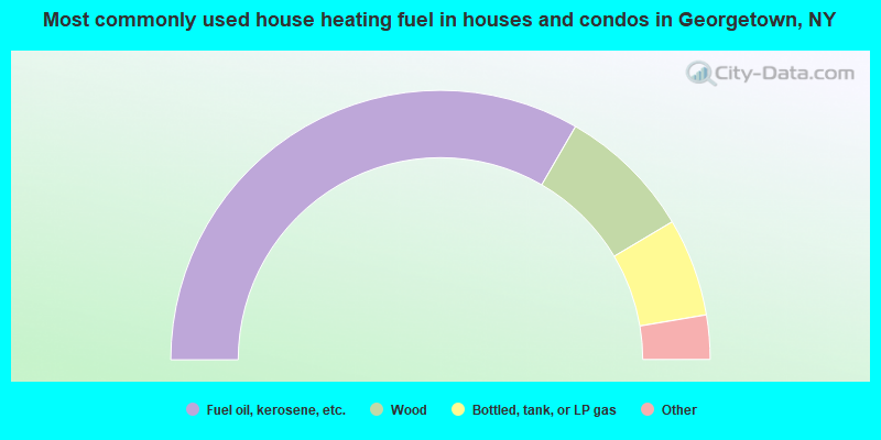
- 66.7%Fuel oil, kerosene, etc.
- 16.2%Wood
- 11.8%Bottled, tank, or LP gas
- 1.8%Electricity
- 1.8%Coal or coke
- 0.9%Utility gas
- 0.9%Other fuel
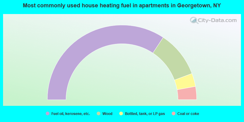
- 68.6%Fuel oil, kerosene, etc.
- 20.0%Wood
- 5.7%Bottled, tank, or LP gas
- 5.7%Coal or coke
Georgetown compared to New York state average:
- Median house value significantly below state average.
- Unemployed percentage significantly below state average.
- Hispanic race population percentage significantly below state average.
- Foreign-born population percentage significantly below state average.
- Renting percentage significantly below state average.
- Length of stay since moving in significantly above state average.
- Number of rooms per house significantly below state average.
- House age significantly below state average.
- Institutionalized population percentage significantly above state average.
- Number of college students below state average.
- Percentage of population with a bachelor's degree or higher significantly below state average.

|
Total of 2 patent applications in 2008-2024.