Gilford, New Hampshire

Gilford: Tannery Hill Covered Bridge est. 1995
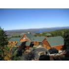
Gilford: View from on top of gunstock Ackers
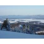
Gilford: View from atop Gunstock Mountain Ski Area looking at Lake Winnipesaukee and the White Mountains
Gilford: Winter 2011 - Old Carriage Lane

Gilford: Smith Cove looking toward Fay's Boat Yard - Gilford, NH
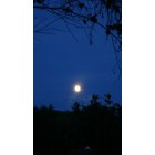
Gilford: Moon from Smith Cove - Gilford, NH

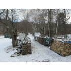
Gilford: Gunstock Brook
- add
your
Submit your own pictures of this town and show them to the world
- OSM Map
- General Map
- Google Map
- MSN Map
Population change since 2000: +4.7%
 |
| Males: 3,463 | |
| Females: 3,663 |
| Median resident age: | 47.9 years |
| New Hampshire median age: | 43.9 years |
Zip codes: 03246.
| Gilford: | $89,227 |
| NH: | $89,992 |
Estimated per capita income in 2022: $64,024 (it was $32,667 in 2000)
Gilford town income, earnings, and wages data
Estimated median house or condo value in 2022: $401,586 (it was $123,800 in 2000)
| Gilford: | $401,586 |
| NH: | $384,700 |
Mean prices in 2022: all housing units: $464,290; detached houses: $503,643; townhouses or other attached units: $657,649; in 2-unit structures: $254,871; in 3-to-4-unit structures: $448,739; in 5-or-more-unit structures: $289,404; mobile homes: $118,878
Detailed information about poverty and poor residents in Gilford, NH


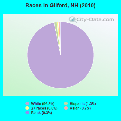
- 6,89996.8%White alone
- 931.3%Hispanic
- 560.8%Two or more races
- 490.7%Asian alone
- 210.3%Black alone
- 40.06%American Indian alone
- 20.03%Native Hawaiian and Other
Pacific Islander alone - 20.03%Other race alone
Races in Gilford detailed stats: ancestries, foreign born residents, place of birth
According to our research of New Hampshire and other state lists, there were 4 registered sex offenders living in Gilford, New Hampshire as of May 02, 2024.
The ratio of all residents to sex offenders in Gilford is 1,782 to 1.
The ratio of registered sex offenders to all residents in this city is much lower than the state average.
Type |
2009 |
2010 |
2011 |
2012 |
2013 |
2014 |
2015 |
2016 |
2017 |
2018 |
2019 |
2020 |
2021 |
2022 |
|---|---|---|---|---|---|---|---|---|---|---|---|---|---|---|
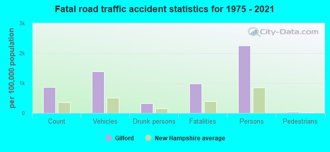
| Murders (per 100,000) | 0 (0.0) | 1 (14.0) | 0 (0.0) | 0 (0.0) | 0 (0.0) | 0 (0.0) | 0 (0.0) | 0 (0.0) | 0 (0.0) | 0 (0.0) | 0 (0.0) | 0 (0.0) | 0 (0.0) | 0 (0.0) |
| Rapes (per 100,000) | 3 (39.9) | 0 (0.0) | 4 (56.1) | 5 (69.9) | 2 (28.0) | 4 (56.2) | 2 (28.0) | 6 (83.5) | 0 (0.0) | 3 (41.6) | 2 (27.8) | 4 (55.1) | 8 (108.2) | 3 (38.1) |
| Robberies (per 100,000) | 3 (39.9) | 1 (14.0) | 1 (14.0) | 0 (0.0) | 1 (14.0) | 1 (14.0) | 0 (0.0) | 0 (0.0) | 1 (13.9) | 2 (27.7) | 0 (0.0) | 0 (0.0) | 0 (0.0) | 0 (0.0) |
| Assaults (per 100,000) | 4 (53.1) | 13 (182.4) | 6 (84.1) | 11 (153.7) | 5 (70.0) | 4 (56.2) | 5 (69.9) | 6 (83.5) | 9 (125.2) | 3 (41.6) | 3 (41.7) | 2 (27.6) | 2 (27.1) | 1 (12.7) |
| Burglaries (per 100,000) | 29 (385.3) | 24 (336.8) | 45 (630.7) | 38 (531.0) | 25 (349.8) | 15 (210.6) | 19 (265.8) | 24 (334.2) | 17 (236.4) | 14 (194.0) | 16 (222.3) | 7 (96.4) | 10 (135.3) | 8 (101.5) |
| Thefts (per 100,000) | 202 (2,684) | 186 (2,610) | 175 (2,453) | 170 (2,376) | 147 (2,057) | 164 (2,303) | 113 (1,581) | 115 (1,601) | 146 (2,030) | 97 (1,344) | 91 (1,264) | 103 (1,419) | 75 (1,015) | 104 (1,320) |
| Auto thefts (per 100,000) | 11 (146.2) | 8 (112.3) | 6 (84.1) | 6 (83.8) | 9 (125.9) | 9 (126.4) | 8 (111.9) | 3 (41.8) | 5 (69.5) | 9 (124.7) | 5 (69.5) | 4 (55.1) | 8 (108.2) | 1 (12.7) |
| Arson (per 100,000) | 1 (13.3) | 0 (0.0) | 0 (0.0) | 0 (0.0) | 0 (0.0) | 1 (14.0) | 0 (0.0) | 0 (0.0) | 1 (13.9) | 3 (41.6) | 0 (0.0) | 1 (13.8) | 2 (27.1) | 0 (0.0) |
| City-Data.com crime index | 200.5 | 205.7 | 214.9 | 225.5 | 157.4 | 177.3 | 127.2 | 174.3 | 132.5 | 127.2 | 102.3 | 117.5 | 150.7 | 93.9 |
The City-Data.com crime index weighs serious crimes and violent crimes more heavily. Higher means more crime, U.S. average is 246.1. It adjusts for the number of visitors and daily workers commuting into cities.

Crime rate in Gilford detailed stats: murders, rapes, robberies, assaults, burglaries, thefts, arson
Full-time law enforcement employees in 2021, including police officers: 24 (18 officers - 17 male; 1 female).
| Officers per 1,000 residents here: | 2.44 |
| New Hampshire average: | 2.14 |
 Recent articles from our blog. Our writers, many of them Ph.D. graduates or candidates, create easy-to-read articles on a wide variety of topics.

 | Move to NH - Suggested Areas & Towns? (108 replies) |
| Drugs in Laconia & Gilford (14 replies) |
| Lake living for retirees (17 replies) |
| Moving to Lakes Region (41 replies) |
| Meredith NH - Other Towns? (30 replies) |
| Thank you to the Portsmouth NH Police for stopping me during a sobriety check on July 28,2017 (63 replies) |
Latest news from Gilford, NH collected exclusively by city-data.com from local newspapers, TV, and radio stations
Ancestries: English (21.0%), Irish (16.8%), French (13.5%), Italian (11.8%), French Canadian (10.8%), German (10.0%).
Current Local Time: EST time zone
Incorporated in 1812
Elevation: 741 feet
Land area: 39.0 square miles.
Population density: 183 people per square mile (very low).

157 residents are foreign born (1.5% Europe, 0.6% Asia).
| This town: | 2.3% |
| New Hampshire: | 4.4% |
| Gilford town: | 2.1% ($2,646) |
| New Hampshire: | 2.3% ($2,946) |
Nearest city with pop. 50,000+: Manchester, NH  (39.9 miles , pop. 107,006).
Nearest city with pop. 200,000+: Boston, MA (87.1 miles , pop. 589,141).
Nearest city with pop. 1,000,000+: Bronx, NY (226.6 miles , pop. 1,332,650).
Nearest cities:
Latitude: 43.56 N, Longitude: 71.40 W
Area code commonly used in this area: 603

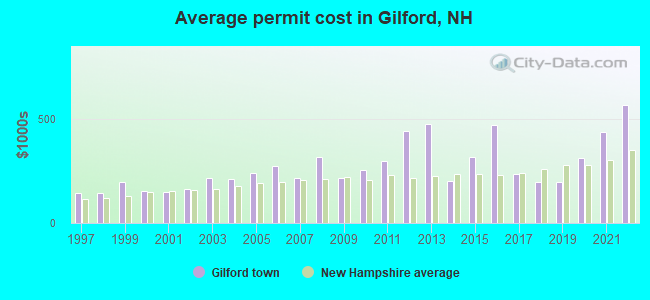
Single-family new house construction building permits:
- 2022: 39 buildings, average cost: $567,800
- 2021: 61 buildings, average cost: $435,700
- 2020: 57 buildings, average cost: $310,700
- 2019: 40 buildings, average cost: $195,500
- 2018: 41 buildings, average cost: $195,500
- 2017: 36 buildings, average cost: $235,300
- 2016: 34 buildings, average cost: $471,900
- 2015: 46 buildings, average cost: $318,200
- 2014: 22 buildings, average cost: $200,100
- 2013: 24 buildings, average cost: $473,900
- 2012: 20 buildings, average cost: $441,600
- 2011: 10 buildings, average cost: $295,500
- 2010: 19 buildings, average cost: $256,500
- 2009: 20 buildings, average cost: $216,800
- 2008: 32 buildings, average cost: $318,800
- 2007: 74 buildings, average cost: $214,800
- 2006: 52 buildings, average cost: $272,800
- 2005: 48 buildings, average cost: $240,900
- 2004: 54 buildings, average cost: $210,100
- 2003: 59 buildings, average cost: $213,500
- 2002: 113 buildings, average cost: $164,100
- 2001: 66 buildings, average cost: $149,600
- 2000: 59 buildings, average cost: $152,100
- 1999: 38 buildings, average cost: $196,000
- 1998: 41 buildings, average cost: $143,200
- 1997: 38 buildings, average cost: $145,700

| Here: | 2.5% |
| New Hampshire: | 2.5% |

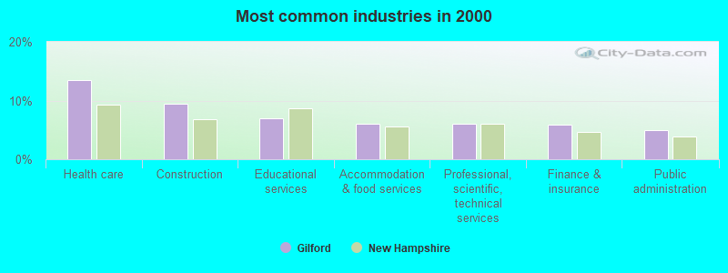
- Health care (13.5%)
- Construction (9.5%)
- Educational services (7.0%)
- Accommodation & food services (6.1%)
- Professional, scientific, technical services (6.0%)
- Finance & insurance (5.9%)
- Public administration (5.0%)
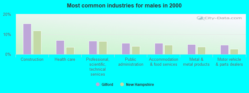
- Construction (15.3%)
- Health care (7.0%)
- Professional, scientific, technical services (6.7%)
- Public administration (5.6%)
- Accommodation & food services (5.6%)
- Metal & metal products (4.9%)
- Motor vehicle & parts dealers (4.7%)
- Health care (20.3%)
- Educational services (10.3%)
- Finance & insurance (7.4%)
- Accommodation & food services (6.6%)
- Social assistance (5.4%)
- Professional, scientific, technical services (5.2%)
- Public administration (4.3%)
- Other sales and related occupations, including supervisors (8.5%)
- Other management occupations, except farmers and farm managers (5.3%)
- Retail sales workers, except cashiers (3.9%)
- Other office and administrative support workers, including supervisors (3.9%)
- Top executives (3.7%)
- Secretaries and administrative assistants (3.4%)
- Building and grounds cleaning and maintenance occupations (3.1%)
- Other sales and related occupations, including supervisors (10.2%)
- Other management occupations, except farmers and farm managers (6.2%)
- Top executives (4.9%)
- Retail sales workers, except cashiers (4.7%)
- Physicians and surgeons (4.2%)
- Electrical equipment mechanics and other installation, maintenance, and repair workers, including supervisors (4.1%)
- Building and grounds cleaning and maintenance occupations (3.9%)
- Other sales and related occupations, including supervisors (6.8%)
- Other office and administrative support workers, including supervisors (6.5%)
- Secretaries and administrative assistants (6.4%)
- Registered nurses (5.2%)
- Other management occupations, except farmers and farm managers (4.2%)
- Health technologists and technicians (3.9%)
- Preschool, kindergarten, elementary, and middle school teachers (3.7%)
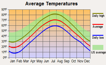
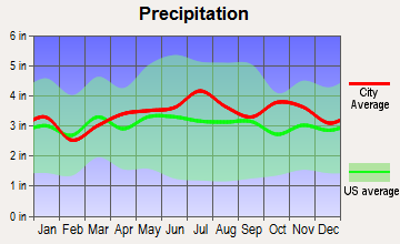
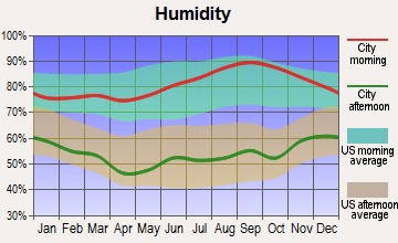
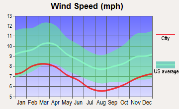
Average climate in Gilford, New Hampshire
Based on data reported by over 4,000 weather stations
(lower is better)
Air Quality Index (AQI) level in 2022 was 51.1. This is significantly better than average.
| City: | 51.1 |
| U.S.: | 72.6 |
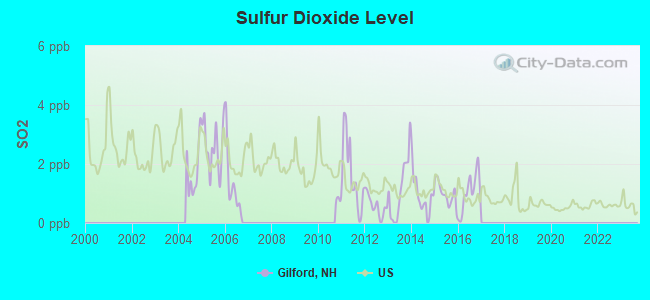
Sulfur Dioxide (SO2) [ppb] level in 2016 was 1.05. This is significantly better than average. Closest monitor was 19.7 miles away from the city center.
| City: | 1.05 |
| U.S.: | 1.51 |
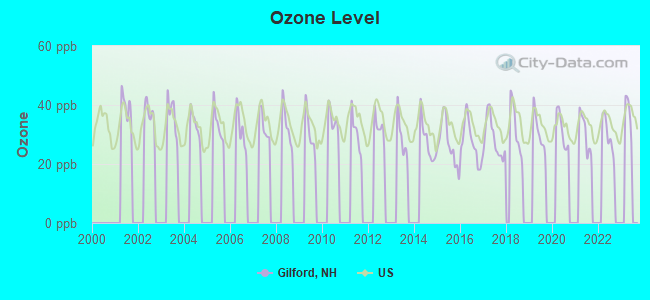
Ozone [ppb] level in 2022 was 29.6. This is about average. Closest monitor was 1.4 miles away from the city center.
| City: | 29.6 |
| U.S.: | 33.3 |
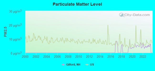
Particulate Matter (PM2.5) [µg/m3] level in 2022 was 4.52. This is significantly better than average. Closest monitor was 1.4 miles away from the city center.
| City: | 4.52 |
| U.S.: | 8.11 |
Tornado activity:
Gilford-area historical tornado activity is slightly below New Hampshire state average. It is 61% smaller than the overall U.S. average.
On 7/3/1972, a category F2 (max. wind speeds 113-157 mph) tornado 9.9 miles away from the Gilford town center injured 7 people and caused between $5000 and $50,000 in damages.
On 7/18/1963, a category F2 tornado 10.2 miles away from the town center caused between $5000 and $50,000 in damages.
Earthquake activity:
Gilford-area historical earthquake activity is significantly above New Hampshire state average. It is 72% smaller than the overall U.S. average.On 4/20/2002 at 10:50:47, a magnitude 5.3 (5.3 ML, Depth: 3.0 mi, Class: Moderate, Intensity: VI - VII) earthquake occurred 132.0 miles away from the city center
On 1/19/1982 at 00:14:42, a magnitude 4.7 (4.5 MB, 4.7 MD, 4.5 LG, Class: Light, Intensity: IV - V) earthquake occurred 11.0 miles away from Gilford center
On 10/7/1983 at 10:18:46, a magnitude 5.3 (5.1 MB, 5.3 LG, 5.1 ML) earthquake occurred 149.6 miles away from the city center
On 4/20/2002 at 10:50:47, a magnitude 5.2 (5.2 MB, 4.2 MS, 5.2 MW, 5.0 MW) earthquake occurred 132.0 miles away from the city center
On 10/16/2012 at 23:12:25, a magnitude 4.7 (4.7 ML, Depth: 10.0 mi) earthquake occurred 37.2 miles away from the city center
On 8/21/1996 at 07:54:14, a magnitude 3.8 (3.8 LG, 3.6 LG, Depth: 6.2 mi, Class: Light, Intensity: II - III) earthquake occurred 43.1 miles away from Gilford center
Magnitude types: regional Lg-wave magnitude (LG), body-wave magnitude (MB), duration magnitude (MD), local magnitude (ML), surface-wave magnitude (MS), moment magnitude (MW)
Natural disasters:
The number of natural disasters in Belknap County (25) is a lot greater than the US average (15).Major Disasters (Presidential) Declared: 16
Emergencies Declared: 7
Causes of natural disasters: Floods: 10, Storms: 10, Winter Storms: 4, Hurricanes: 3, Snows: 2, Tropical Storms: 2, Blizzard: 1, Heavy Rain: 1, Ice Storm: 1, Snowfall: 1, Snowstorm: 1, Tornado: 1, Wind: 1, Other: 1 (Note: some incidents may be assigned to more than one category).
Hospitals and medical centers near Gilford:
- LAKES REGION GENERAL HOSPITAL Acute Care Hospitals (about 4 miles away; LACONIA, NH)
- CENTRAL NEW HAMPSHIRE KIDNEY CENTER (Dialysis Facility, about 4 miles away; LACONIA, NH)
- COMMUNITY HEALTH AND HOSPICE (Home Health Center, about 5 miles away; LACONIA, NH)
- BELKNAP COUNTY NURSING HOME (Nursing Home, about 5 miles away; LACONIA, NH)
- LACONIA CENTER, GENESIS HEALTHCARE (Nursing Home, about 5 miles away; LACONIA, NH)
- SAINT FRANCIS REHABILITATION AND NURSING CENTER (Nursing Home, about 6 miles away; LACONIA, NH)
- WOLFEBORO BAY CARE AND REHABILITATION CENTER (Nursing Home, about 10 miles away; WOLFEBORO, NH)
Colleges/universities with over 2000 students nearest to Gilford:
- Plymouth State University (about 21 miles; Plymouth, NH; Full-time enrollment: 4,838)
- NHTI-Concord's Community College (about 25 miles; Concord, NH; FT enrollment: 2,865)
- Southern New Hampshire University (about 37 miles; Manchester, NH; FT enrollment: 16,552)
- University of New Hampshire-Main Campus (about 38 miles; Durham, NH; FT enrollment: 15,243)
- Saint Anselm College (about 41 miles; Manchester, NH; FT enrollment: 2,059)
- Mount Washington College (about 41 miles; Manchester, NH; FT enrollment: 2,187)
- Dartmouth College (about 46 miles; Hanover, NH; FT enrollment: 6,030)
Public high school in Gilford:
- GILFORD HIGH SCHOOL (Students: 575, Location: 88 ALVAH WILSON RD., Grades: 9-12)
Public elementary/middle schools in Gilford:
- GILFORD ELEMENTARY SCHOOL (Students: 404, Location: 76 BELKNAP MOUNTAIN RD., Grades: KG-4)
- GILFORD MIDDLE SCHOOL (Students: 382, Location: 72 ALVAH WILSON RD., Grades: 5-8)
Points of interest:
Notable locations in Gilford: Alpine Ridge Ski Area (A), Gilford Hills Tennis and Fitness Center (B), Gunstock Acres (C), Gunstock Recreation Area (D), Mount Washington Boat Route (E), Pheasant Ridge Country Club (F), Stonybrook Farm (G), Guilford Public Library (H), Gilford Fire Rescue Department (I), Gunstock Safety Service (J). Display/hide their locations on the map
Shopping Centers: Belknap Mall Shopping Center (1), Kellers Shopping Plaza Shopping Center (2), Lakes Region Plaza Shopping Center (3). Display/hide their locations on the map
Churches in Gilford include: Immaculate Conception Church (A), Guilford Community Church (B). Display/hide their locations on the map
Cemeteries: Pine Grove Cemetery (1), McCoy Cemetery (2). Display/hide their locations on the map
Lakes: Lily Pond (A), Round Pond (B), Saltmarsh Pond (C), Lake Winnipesaukee (D). Display/hide their locations on the map
Streams, rivers, and creeks: Poorfarm Brook (A), Meadow Brook (B), Gunstock River (C). Display/hide their locations on the map
Parks in Gilford include: Ellacoya State Park (1), Ellacoya State Recreational Vehicle Park (2), Belknap Mountain State Forest (3). Display/hide their locations on the map
Beach: Gilford Beach (A). Display/hide its location on the map
Tourist attraction: Amalfi Racing Legends (Museums; 29 Gilford East Drive) (1). Display/hide its approximate location on the map
Hotels: Silver Sands Motel & Marina - Motel (Route 11B) (1), Inn at Smith Cove (19 Roberts Rd) (2), B Mae's Resort Inn & Suites (Route 11 & 11B) (3), Ellacoya Resort & Cottages (110 Scenic Drive) (4), Meadowbrook Farm Box Office (72 Meadowbrook Lane) (5), Greystone Motor Inn & Motel (132 Scenic Drive) (6), Belknap Point Motel (107 Belknap Point Road) (7), Misty Harbor Rentals Resman Inc (72 Meadowbrook Lane) (8), Misty Harbor Resort Hotel (Route 11B) (9). Display/hide their approximate locations on the map
Drinking water stations with addresses in Gilford and their reported violations in the past:
GUNSTOCK ACRES VILLAGE DIST (Population served: 1,440, Groundwater):Past monitoring violations:LAKE SHORE PARK (Address: 2600 LAKE SHORE RD , Population served: 790, Groundwater):
- One regular monitoring violation
Past health violations:GROUSE POINT CLUB (Population served: 203, Groundwater):Past monitoring violations:
- MCL, Monthly (TCR) - In JUN-2009, Contaminant: Coliform. Follow-up actions: St Public Notif requested (JUN-17-2009), St Violation/Reminder Notice (JUN-17-2009), St Formal NOV issued (JUN-22-2009), St Public Notif received (AUG-24-2009), St Compliance achieved (FEB-16-2010)
- MCL, Monthly (TCR) - In MAY-2009, Contaminant: Coliform. Follow-up actions: St Public Notif requested (MAY-14-2009), St Violation/Reminder Notice (MAY-14-2009), St Public Notif received (MAY-27-2009), St Formal NOV issued (JUN-22-2009), St Compliance achieved (FEB-16-2010)
- MCL, Average - Between OCT-2008 and DEC-2008, Contaminant: Arsenic. Follow-up actions: St Public Notif requested (JAN-23-2009), St Violation/Reminder Notice (JAN-23-2009), St Public Notif received (FEB-12-2009), St Compliance achieved (MAY-01-2009)
- MCL, Average - Between JUL-2008 and SEP-2008, Contaminant: Arsenic. Follow-up actions: St Public Notif requested (OCT-14-2008), St Violation/Reminder Notice (OCT-14-2008), St Public Notif received (NOV-06-2008), St Compliance achieved (MAY-01-2009)
- MCL, Average - Between APR-2008 and JUN-2008, Contaminant: Arsenic. Follow-up actions: St Public Notif requested (MAY-12-2008), St Violation/Reminder Notice (MAY-12-2008), St Public Notif received (JUN-16-2008), St Compliance achieved (MAY-01-2009)
- MCL, Average - Between JAN-2008 and MAR-2008, Contaminant: Arsenic. Follow-up actions: St Public Notif requested (MAR-21-2008), St Violation/Reminder Notice (MAR-21-2008), St Public Notif received (APR-11-2008), St Compliance achieved (MAY-01-2009)
- 4 other older health violations
- One minor monitoring violation
Past health violations:JONATHANS LANDING CONDOS (Population served: 158, Groundwater):Past monitoring violations:
- MCL, Monthly (TCR) - In OCT-2012, Contaminant: Coliform. Follow-up actions: St Public Notif requested (OCT-23-2012), St Violation/Reminder Notice (OCT-23-2012), St Public Notif received (NOV-09-2012), St Formal NOV issued (NOV-19-2012), St Compliance achieved (APR-16-2013)
- MCL, Monthly (TCR) - In SEP-2012, Contaminant: Coliform. Follow-up actions: St Public Notif requested (SEP-20-2012), St Violation/Reminder Notice (SEP-20-2012), St Public Notif received (OCT-03-2012), St Formal NOV issued (NOV-19-2012), St Compliance achieved (APR-16-2013)
- One routine major monitoring violation
Past health violations:DOCKHAM SHORES ESTATES (Population served: 150, Groundwater):
- MCL, Monthly (TCR) - In JAN-2014, Contaminant: Coliform. Follow-up actions: St Public Notif requested (JAN-21-2014), St Violation/Reminder Notice (JAN-21-2014), St Public Notif received (JAN-30-2014)
Past health violations:BROOKSIDE CROSSING (Population served: 138, Groundwater):Past monitoring violations:
- MCL, Monthly (TCR) - In OCT-2011, Contaminant: Coliform. Follow-up actions: St Public Notif requested (OCT-17-2011), St Violation/Reminder Notice (OCT-17-2011), St Public Notif received (DEC-01-2011), St Compliance achieved (APR-16-2012)
- MCL, Monthly (TCR) - In SEP-2011, Contaminant: Coliform. Follow-up actions: St Formal NOV issued (OCT-06-2011), St Public Notif requested (OCT-06-2011), St Public Notif received (OCT-06-2011), St Compliance achieved (APR-16-2012)
- MCL, Monthly (TCR) - In AUG-2011, Contaminant: Coliform. Follow-up actions: St Public Notif requested (SEP-27-2011), St Violation/Reminder Notice (SEP-27-2011), St Formal NOV issued (OCT-06-2011), St Public Notif received (OCT-21-2011), St Compliance achieved (APR-16-2012)
- MCL, Acute (TCR) - In NOV-2010, Contaminant: Coliform. Follow-up actions: St Public Notif requested (NOV-10-2010), St Formal NOV issued (NOV-18-2010), St Public Notif received (NOV-22-2010), St Compliance achieved (JUN-02-2011)
- MCL, Acute (TCR) - In OCT-2010, Contaminant: Coliform. Follow-up actions: St Public Notif requested (OCT-21-2010), St Violation/Reminder Notice (OCT-21-2010), St Public Notif received (OCT-26-2010), St Formal NOV issued (NOV-18-2010), St Compliance achieved (JUN-02-2011)
- Monitoring, Source Water (GWR) - Between NOV-01-2011 and DEC-01-2011, Contaminant: E. COLI. Follow-up actions: St Public Notif requested (DEC-06-2011), St Violation/Reminder Notice (DEC-06-2011), St Compliance achieved (DEC-07-2011), St Public Notif received (DEC-21-2011)
- One minor monitoring violation
- 23 regular monitoring violations
Past health violations:GILFORD VILLAGE WATER DIST (Population served: 130, Groundwater):Past monitoring violations:
- MCL, Monthly (TCR) - In SEP-2006, Contaminant: Coliform. Follow-up actions: St Public Notif requested (SEP-15-2006), St Violation/Reminder Notice (SEP-15-2006), St Public Notif received (SEP-21-2006), St Compliance achieved (MAR-30-2007)
- Follow-up Or Routine LCR Tap M/R - In JUL-01-2004, Contaminant: Lead and Copper Rule. Follow-up actions: St Public Notif requested (JAN-25-2005), St Violation/Reminder Notice (JAN-25-2005), St Public Notif received (FEB-01-2005), St Compliance achieved (FEB-11-2005)
Past health violations:MICHAWANIC VILLAGE CONDOS (Population served: 120, Groundwater):Past monitoring violations:
- MCL, Monthly (TCR) - In AUG-2011, Contaminant: Coliform. Follow-up actions: St Public Notif requested (AUG-30-2011), St Formal NOV issued (AUG-30-2011), St Public Notif received (SEP-09-2011), St Compliance achieved (FEB-24-2012)
- MCL, Monthly (TCR) - In JUL-2011, Contaminant: Coliform. Follow-up actions: St Public Notif requested (JUL-25-2011), St Violation/Reminder Notice (JUL-25-2011), St Public Notif received (AUG-10-2011), St Formal NOV issued (AUG-30-2011), St Compliance achieved (FEB-24-2012)
- MCL, Monthly (TCR) - In FEB-2009, Contaminant: Coliform. Follow-up actions: St Public Notif requested (FEB-18-2009), St Violation/Reminder Notice (FEB-18-2009), St Public Notif received (MAR-06-2009), St Compliance achieved (SEP-09-2009)
- MCL, Monthly (TCR) - In OCT-2008, Contaminant: Coliform. Follow-up actions: St Public Notif requested (OCT-28-2008), St Violation/Reminder Notice (OCT-28-2008), St Public Notif received (NOV-05-2008), St Compliance achieved (SEP-09-2009)
- MCL, Monthly (TCR) - In SEP-2008, Contaminant: Coliform. Follow-up actions: St Public Notif requested (OCT-09-2008), St Violation/Reminder Notice (OCT-09-2008), St Formal NOV issued (OCT-14-2008), St Public Notif received (OCT-17-2008), St Compliance achieved (SEP-09-2009)
- MCL, Monthly (TCR) - In JUL-2008, Contaminant: Coliform. Follow-up actions: St Public Notif requested (JUL-25-2008), St Violation/Reminder Notice (JUL-25-2008), St Public Notif received (JUL-31-2008), St Formal NOV issued (OCT-14-2008), St Compliance achieved (SEP-09-2009)
- Lead Consumer Notice - In JUL-01-2012, Contaminant: Lead and Copper Rule. Follow-up actions: St Violation/Reminder Notice (JUL-10-2012), St Compliance achieved (JUL-16-2012)
- Monitoring, Source Water (GWR) - Between SEP-01-2011 and OCT-01-2011, Contaminant: E. COLI. Follow-up actions: St Public Notif requested (NOV-14-2011), St Violation/Reminder Notice (NOV-14-2011), St Public Notif received (NOV-18-2011), St Compliance achieved (NOV-23-2011)
Past health violations:Past monitoring violations:
- MCL, Monthly (TCR) - In OCT-2013, Contaminant: Coliform. Follow-up actions: St Public Notif requested (OCT-28-2013), St Violation/Reminder Notice (OCT-28-2013), St Public Notif received (NOV-06-2013), St Compliance achieved (MAY-16-2014)
- Public Education - In OCT-01-2007, Contaminant: Lead and Copper Rule. Follow-up actions: St Public Notif requested (FEB-12-2008), St Violation/Reminder Notice (FEB-12-2008), St Formal NOV issued (APR-21-2008), St Public Notif received (MAY-15-2008), St Compliance achieved (MAY-15-2008)
- Water Quality Parameter M/R - In JAN-01-2011, Contaminant: Lead and Copper Rule. Follow-up actions: St Violation/Reminder Notice (AUG-09-2011), St Compliance achieved (AUG-11-2011)
- Follow-up Or Routine LCR Tap M/R - In JAN-01-2010, Contaminant: Lead and Copper Rule. Follow-up actions: St Violation/Reminder Notice (FEB-03-2010), St Compliance achieved (FEB-08-2010)
- Follow-up Or Routine LCR Tap M/R - In OCT-01-2004, Contaminant: Lead and Copper Rule. Follow-up actions: St Public Notif requested (JAN-21-2005), St Violation/Reminder Notice (JAN-21-2005), St Compliance achieved (JAN-27-2005), St Public Notif received (FEB-25-2005)
- One regular monitoring violation
Drinking water stations with addresses in Gilford that have no violations reported:
- RESORT ON THE BAY (Population served: 328, Primary Water Source Type: Groundwater)
- LRMHV (Population served: 233, Primary Water Source Type: Groundwater)
- SILVER SAND RESORT (Population served: 165, Primary Water Source Type: Groundwater)
- EDGE OF WOODS (Population served: 120, Primary Water Source Type: Groundwater)
- COUNTRY VILLAGE WAY (Population served: 100, Primary Water Source Type: Groundwater)
- HAMPSHIRE VILLAGE (Population served: 40, Primary Water Source Type: Groundwater)
- HARBOURSIDE ON WINNIPESAUKEE (Population served: 40, Primary Water Source Type: Groundwater)
- SILVER SANDS MARINA (Address: 103 WEIRS RD , Population served: 35, Primary Water Source Type: Groundwater)
- CHALET VILLAGE (Population served: 35, Primary Water Source Type: Groundwater)
| This town: | 2.4 people |
| New Hampshire: | 2.5 people |
| This town: | 69.3% |
| Whole state: | 66.3% |
| This town: | 6.2% |
| Whole state: | 8.3% |
Likely homosexual households (counted as self-reported same-sex unmarried-partner households)
- Lesbian couples: 0.5% of all households
- Gay men: 0.6% of all households
| This town: | 3.3% |
| Whole state: | 6.5% |
| This town: | 1.3% |
| Whole state: | 2.8% |
Banks with branches in Gilford (2011 data):
- Laconia Savings Bank: Gilford Branch at 1441 Lakeshore Road, branch established on 1979/02/09; Gilford Village Office at One Country Club Road, branch established on 1982/02/16. Info updated 2009/02/12: Bank assets: $1,107.3 mil, Deposits: $876.1 mil, headquarters in Laconia, NH, positive income, Commercial Lending Specialization, 23 total offices, Holding Company: Lsb Financial
- TD Bank, National Association: Gilford Shop N Save Super. Branch at 1402 Lake Shore Road, branch established on 1998/03/05. Info updated 2010/10/04: Bank assets: $188,912.6 mil, Deposits: $153,149.8 mil, headquarters in Wilmington, DE, positive income, 1314 total offices, Holding Company: Toronto-Dominion Bank, The
- Meredith Village Savings Bank: Gilford Branch at 1383 Lakeshore Road, branch established on 1999/06/10. Info updated 2009/03/03: Bank assets: $669.2 mil, Deposits: $513.6 mil, headquarters in Meredith, NH, positive income, Commercial Lending Specialization, 13 total offices
- Franklin Savings Bank: Gilford Branch at 11 Saw Mill Road, branch established on 2007/06/30. Info updated 2006/11/03: Bank assets: $356.8 mil, Deposits: $268.6 mil, headquarters in Franklin, NH, positive income, Mortgage Lending Specialization, 9 total offices
For population 15 years and over in Gilford:
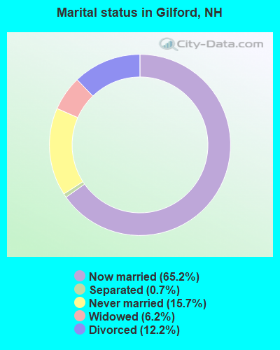
- Never married: 15.7%
- Now married: 65.2%
- Separated: 0.7%
- Widowed: 6.2%
- Divorced: 12.2%
For population 25 years and over in Gilford:
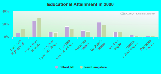
- High school or higher: 93.7%
- Bachelor's degree or higher: 34.9%
- Graduate or professional degree: 11.9%
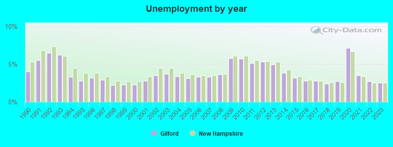
- Unemployed: 1.8%
- Mean travel time to work (commute): 22.8 minutes
| Here: | 9.4 |
| New Hampshire average: | 10.9 |
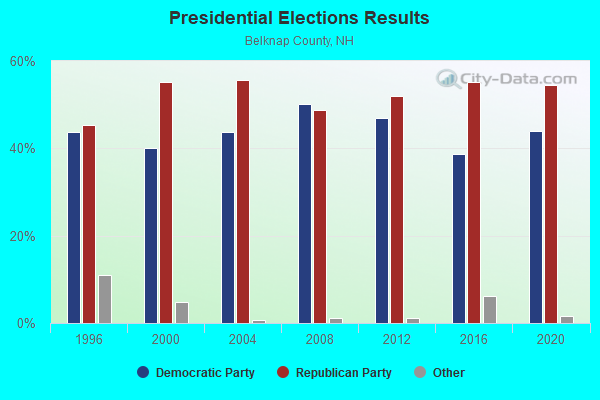
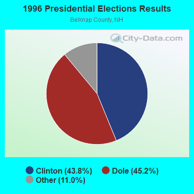


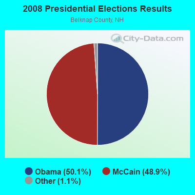
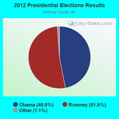
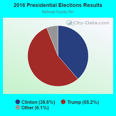
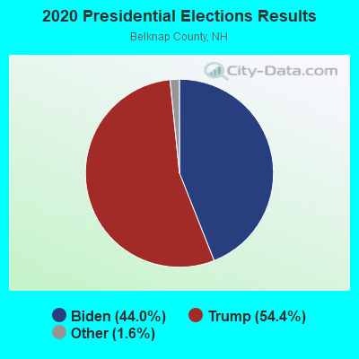
Graphs represent county-level data. Detailed 2008 Election Results
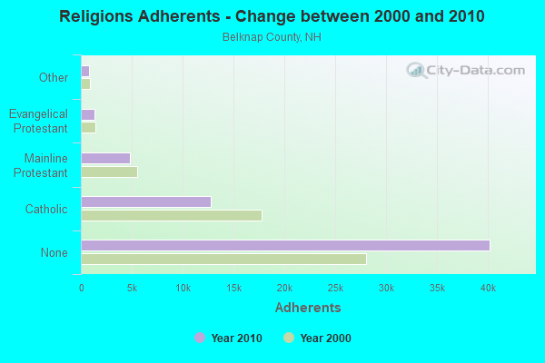
Religion statistics for Gilford, NH (based on Belknap County data)
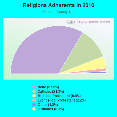
| Religion | Adherents | Congregations |
|---|---|---|
| Catholic | 12,810 | 8 |
| Mainline Protestant | 4,819 | 26 |
| Evangelical Protestant | 1,315 | 19 |
| Other | 793 | 4 |
| Orthodox | 120 | 1 |
| None | 40,231 | - |
Food Environment Statistics:
| Here: | 2.46 / 10,000 pop. |
| New Hampshire: | 2.14 / 10,000 pop. |
| Here: | 0.16 / 10,000 pop. |
| New Hampshire: | 0.15 / 10,000 pop. |
| Belknap County: | 1.47 / 10,000 pop. |
| New Hampshire: | 1.78 / 10,000 pop. |
| Here: | 4.91 / 10,000 pop. |
| New Hampshire: | 4.02 / 10,000 pop. |
| This county: | 13.10 / 10,000 pop. |
| New Hampshire: | 9.70 / 10,000 pop. |
| This county: | 8.5% |
| New Hampshire: | 7.6% |
| Belknap County: | 25.0% |
| New Hampshire: | 24.4% |
| Belknap County: | 20.8% |
| New Hampshire: | 15.9% |
| Businesses in Gilford, NH | ||||
| Name | Count | Name | Count | |
|---|---|---|---|---|
| CVS | 1 | Nike | 1 | |
| Decora Cabinetry | 2 | Payless | 1 | |
| Dunkin Donuts | 2 | Shaw's | 1 | |
| Fashion Bug | 1 | T.J.Maxx | 1 | |
| FedEx | 2 | True Value | 1 | |
| GameStop | 1 | U-Haul | 1 | |
| Lowe's | 1 | UPS | 2 | |
| Marriott | 1 | Walmart | 1 | |
| MasterBrand Cabinets | 4 | Wendy's | 1 | |
Strongest AM radio stations in Gilford:
- WEZS (1350 AM; 5 kW; LACONIA, NH; Owner: GARY W. HAMMOND)
- WEMJ (1490 AM; 1 kW; LACONIA, NH; Owner: WLNH RADIO, INC.)
- WASR (1420 AM; 5 kW; WOLFEBORO, NH; Owner: RADIO WOLFEBORO, INC.)
- WRKO (680 AM; 50 kW; BOSTON, MA; Owner: ENTERCOM BOSTON LICENSE, LLC)
- WGIN (930 AM; 10 kW; ROCHESTER, NH; Owner: CAPSTAR TX LIMITED PARTNERSHIP)
- WPNH (1300 AM; 5 kW; PLYMOUTH, NH; Owner: NORTHEAST COMMUNICATIONS CORPORATION)
- WEEI (850 AM; 50 kW; BOSTON, MA; Owner: ENTERCOM BOSTON LICENSE, LLC)
- WCRN (830 AM; 50 kW; WORCESTER, MA; Owner: CARTER BROADCASTING CORPORATION)
- WBZ (1030 AM; 50 kW; BOSTON, MA; Owner: INFINITY BROADCASTING OPERATIONS, INC.)
- WNTK (1020 AM; 10 kW; NEWPORT, NH; Owner: KOOR COMMUNICATIONS, INC.)
- WKOX (1200 AM; 50 kW; FRAMINGHAM, MA; Owner: CAPSTAR TX LIMITED PARTNERSHIP)
- WMTW (870 AM; 10 kW; GORHAM, ME; Owner: RADIO PARTNERS OF MAINE, L.P.)
- WGIR (610 AM; 5 kW; MANCHESTER, NH; Owner: CAPSTAR TX LIMITED PARTNERSHIP)
Strongest FM radio stations in Gilford:
- WLKZ (104.9 FM; WOLFEBORO, NH; Owner: TELE-MEDIA COMPANY OF NEW HAMPSHIRE, L.L.C.)
- WSCY (106.9 FM; MOULTONBOROUGH, NH; Owner: NORTHEAST COMMUNICATIONS CORPORATION)
- WLNH-FM (98.3 FM; LACONIA, NH; Owner: WLNH RADIO, INC)
- WBHG (101.5 FM; MEREDITH, NH; Owner: WLNH RADIO, INC)
- WNHI (93.3 FM; BELMONT, NH; Owner: CONCORD BROADCASTING, L.L.C.)
- WVFM (105.7 FM; CAMPTON, NH; Owner: DEVON BROADCASTING COMPANY, INC.)
- WPKQ (103.7 FM; NORTH CONWAY, NH; Owner: CITADEL BROADCASTING COMPANY)
- WHOM (94.9 FM; MT. WASHINGTON, NH; Owner: CITADEL BROADCASTING COMPANY)
- WMEX (106.5 FM; FARMINGTON, NH; Owner: WIMMEX, LLC)
- WPNH-FM (100.1 FM; PLYMOUTH, NH; Owner: NORTHEAST COMMUNICATIONS CORPORATION)
- WFTN-FM (94.1 FM; FRANKLIN, NH; Owner: NORTHEAST COMMUNICATIONS CORPORATION)
- WMEA (90.1 FM; PORTLAND, ME; Owner: MAINE PUBLIC BROADCASTING CORPORATION)
- WHDQ (106.1 FM; CLAREMONT, NH; Owner: GREAT NORTHERN RADIO, L.L.C.)
- WVPR (89.5 FM; WINDSOR, VT; Owner: VERMONT PUBLIC RADIO)
- WEVH (91.3 FM; HANOVER, NH; Owner: NEW HAMPSHIRE PUBLIC RADIO INC)
- W264AH (100.7 FM; LACONIA, NH; Owner: KNIGHT RADIO, INC.)
- WJYY (105.5 FM; CONCORD, NH; Owner: CONCORD BROADCASTING, L.L.C.)
- WJJR (98.1 FM; RUTLAND, VT; Owner: 6 JOHNSON ROAD LICENSES, INC.)
- WZRT (97.1 FM; RUTLAND, VT; Owner: CAPSTAR TX LIMITED PARTNERSHIP)
- W282AF (104.3 FM; CONCORD, NH; Owner: CONCORD BIBLE FELLOWSHIP)
TV broadcast stations around Gilford:
- WMEA-TV (Channel 26; BIDDEFORD, ME; Owner: MAINE PUBLIC BROADCASTING CORP.)
- WMTW-TV (Channel 8; POLAND SPRING, ME; Owner: WMTW BROADCAST GROUP, LLC)
- WCSH (Channel 6; PORTLAND, ME; Owner: PACIFIC AND SOUTHERN COMPANY, INC.)
- WGME-TV (Channel 13; PORTLAND, ME; Owner: WGME LICENSEE, LLC)
- WENH-TV (Channel 11; DURHAM, NH; Owner: UNIVERSITY OF NEW HAMPSHIRE)
- National Bridge Inventory (NBI) Statistics
- 22Number of bridges
- 85ft / 25.9mTotal length
- $62,840,000Total costs
- 77,680Total average daily traffic
- 5,001Total average daily truck traffic

- New bridges - historical statistics
- 11900-1909
- 21920-1929
- 21930-1939
- 21940-1949
- 11950-1959
- 81960-1969
- 21970-1979
- 11980-1989
- 22000-2009
- 12010-2019
FCC Registered Antenna Towers: 83 (See the full list of FCC Registered Antenna Towers)
FCC Registered Private Land Mobile Towers: 1 (See the full list of FCC Registered Private Land Mobile Towers in Gilford, NH)
FCC Registered Broadcast Land Mobile Towers: 25 (See the full list of FCC Registered Broadcast Land Mobile Towers)
FCC Registered Microwave Towers: 20 (See the full list of FCC Registered Microwave Towers in this town)
FCC Registered Paging Towers: 4 (See the full list of FCC Registered Paging Towers)
FCC Registered Maritime Coast & Aviation Ground Towers: 2 (See the full list of FCC Registered Maritime Coast & Aviation Ground Towers)
FCC Registered Amateur Radio Licenses: 97 (See the full list of FCC Registered Amateur Radio Licenses in Gilford)
FAA Registered Aircraft Manufacturers and Dealers: 1 (See the full list of FAA Registered Manufacturers and Dealers in Gilford)
FAA Registered Aircraft: 26 (See the full list of FAA Registered Aircraft)
2002 - 2018 National Fire Incident Reporting System (NFIRS) incidents
- Fire incident types reported to NFIRS in Gilford, NH
- 40750.9%Structure Fires
- 22728.4%Outside Fires
- 9011.2%Mobile Property/Vehicle Fires
- 769.5%Other
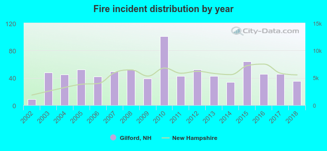 According to the data from the years 2002 - 2018 the average number of fire incidents per year is 47. The highest number of reported fires - 101 took place in 2010, and the least - 9 in 2002. The data has a growing trend.
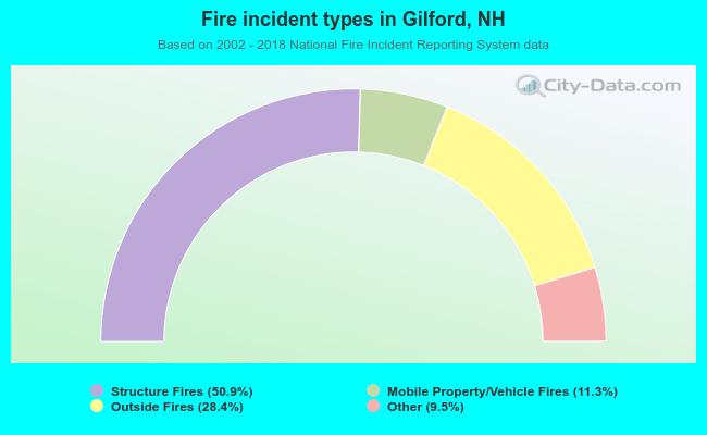 When looking into fire subcategories, the most reports belonged to: Structure Fires (50.9%), and Outside Fires (28.4%).
Fire-safe hotels and motels in Gilford, New Hampshire:
- Misty Harbor Resort Hotel, 118 Weirs Rd, Rt 11B, Gilford, New Hampshire 03249 , Phone: (603) 293-4500, Fax: (603) 293-0493
- Fireside Inn & Suites, 17 Harris Shore Rd, Gilford, New Hampshire 03246 , Phone: (603) 293-7526, Fax: (603) 293-4340
- Towneplace Suites, 14 Sawmill Rd, Gilford, New Hampshire 03249 , Phone: (603) 524-5533, Fax: (603) 524-2422
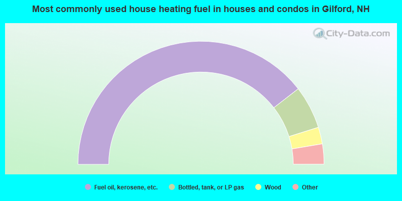
- 79.0%Fuel oil, kerosene, etc.
- 11.3%Bottled, tank, or LP gas
- 4.4%Wood
- 3.1%Electricity
- 1.1%Coal or coke
- 1.0%Utility gas
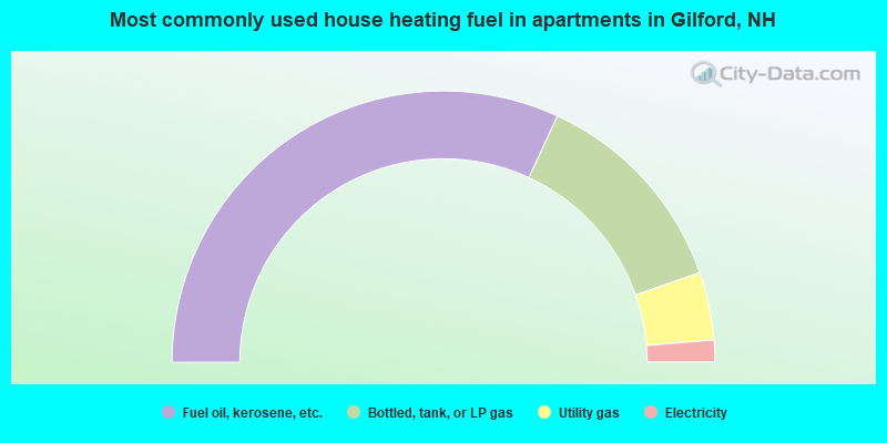
- 63.8%Fuel oil, kerosene, etc.
- 25.5%Bottled, tank, or LP gas
- 8.1%Utility gas
- 2.6%Electricity
Gilford compared to New Hampshire state average:
- Unemployed percentage significantly below state average.
- Black race population percentage significantly below state average.
- Hispanic race population percentage significantly below state average.
- Foreign-born population percentage significantly below state average.
- Renting percentage below state average.
- Length of stay since moving in significantly above state average.
- Number of rooms per house significantly below state average.
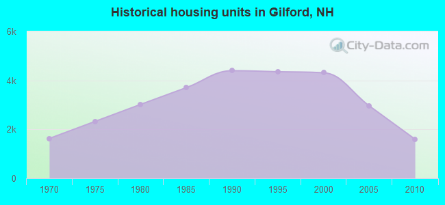
- House age significantly below state average.
Gilford on our top lists:
- #1 on the list of "Top 101 cities with largest percentage of females in occupations: supervisors of transportation and material moving workers (population 5,000+)"
- #5 on the list of "Top 101 cities with largest percentage of males in occupations: special education teachers (population 5,000+)"
- #6 on the list of "Top 101 cities with largest percentage of males in occupations: other sales and related workers including supervisors (population 5,000+)"
- #18 on the list of "Top 101 cities with largest percentage of males in occupations: mathematical science occupations (population 5,000+)"
- #22 on the list of "Top 101 cities with largest percentage of males in industries: other direct selling establishments (population 5,000+)"
- #23 on the list of "Top 101 cities with largest percentage of females in occupations: supervisors of construction and extraction workers (population 5,000+)"
- #32 on the list of "Top 101 cities with largest percentage of males in occupations: physicians and surgeons (population 5,000+)"
- #34 on the list of "Top 101 cities with largest percentage of females in industries: used merchandise, gift, novelty, and souvenir, and other miscellaneous stores (population 5,000+)"
- #37 on the list of "Top 101 cities with largest percentage of males in industries: leather and allied products (population 5,000+)"
- #38 on the list of "Top 101 cities with largest percentage of males in industries: motor vehicle and parts dealers (population 5,000+)"
- #39 on the list of "Top 101 cities with largest percentage of females in industries: electronic shopping and mail-order houses (population 5,000+)"
- #39 on the list of "Top 101 cities with largest percentage of males in industries: music stores (population 5,000+)"
- #46 on the list of "Top 101 cities with largest percentage of females in industries: other direct selling establishments (population 5,000+)"
- #55 on the list of "Top 101 cities with largest percentage of females in industries: other transportation, and support activities, and couriers (population 5,000+)"
- #57 on the list of "Top 101 cities with largest percentage of females in industries: fuel dealers (population 5,000+)"
- #81 on the list of "Top 101 cities with largest percentage of males in industries: gasoline stations (population 5,000+)"
- #83 on the list of "Top 101 cities with largest percentage of females in industries: sporting goods, camera, and hobby and toy stores (population 5,000+)"
- #98 (03246) on the list of "Top 101 zip codes with the largest percentage of French Canadian first ancestries (pop 5,000+)"
- #50 on the list of "Top 101 counties with the largest increase in the number of deaths per 1000 residents 2000-2006 to 2007-2013 (pop. 50,000+)"
- #57 on the list of "Top 101 counties with the lowest total withdrawal of fresh water for public supply (pop. 50,000+)"
- #78 on the list of "Top 101 counties with the lowest Particulate Matter (PM2.5) Annual air pollution readings in 2012 (µg/m3)"

|
|
Total of 45 patent applications in 2008-2024.