Hanover, Minnesota
Submit your own pictures of this city and show them to the world
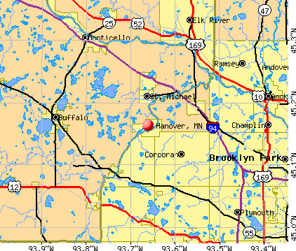
- OSM Map
- General Map
- Google Map
- MSN Map
Population change since 2000: +178.2%
| Males: 1,854 | |
| Females: 1,915 |
| Median resident age: | 36.7 years |
| Minnesota median age: | 39.0 years |
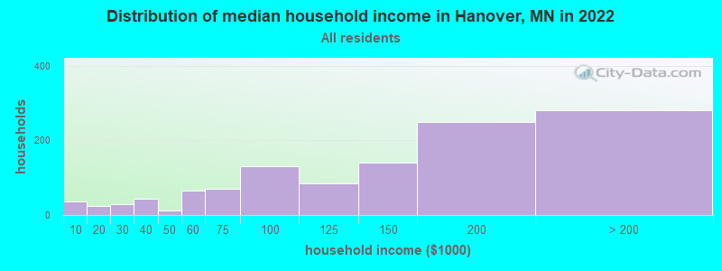
| Hanover: | $131,937 |
| MN: | $82,338 |
Estimated per capita income in 2022: $54,157 (it was $27,826 in 2000)
Hanover city income, earnings, and wages data
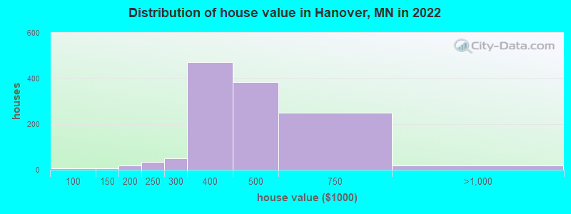
Estimated median house or condo value in 2022: $433,084 (it was $172,400 in 2000)
| Hanover: | $433,084 |
| MN: | $314,600 |
Mean prices in 2022: all housing units: $508,973; detached houses: $508,559
Median gross rent in 2022: $1,706.
(3.4% for White Non-Hispanic residents, 100.0% for Black residents)
Detailed information about poverty and poor residents in Hanover, MN

Compare current foreclosures near Hanover, MN:
| Photo | Address | Area | Beds / Baths | Price | Details |
|---|---|---|---|---|---|

|
#1
12th St NE
Hanover, MN 55341
|
- sq. feet
|
- baths - beds |
show details | |

|
#2
Jordan Ave NE
Hanover, MN 55341
|
- sq. feet
|
- baths - beds |
show details | |

|
#3
Emmy Ln
Hanover, MN 55341
|
- sq. feet
|
- baths - beds |
show details | |

|
#4
Quebec Ave N
Minneapolis, MN 55428
|
1,226 sq. feet
|
1 baths 2 beds |
$334,500
|
show details |

|
#5
Fairview Ln
Mound, MN 55364
|
2,112 sq. feet
|
2 baths 3 beds |
$389,900
|
show details |

|
#6
Foxglove Ave N
Minneapolis, MN 55443
|
2,968 sq. feet
|
3 baths 4 beds |
show details | |

|
#7
Edinbrook Ter
Minneapolis, MN 55443
|
1,724 sq. feet
|
3 baths 3 beds |
show details | |

|
#8
Johnson St
Anoka, MN 55303
|
1,094 sq. feet
|
2 baths 3 beds |
show details | |

|
#9
Ladyslipper Ave N
Minneapolis, MN 55443
|
1,366 sq. feet
|
2 baths 5 beds |
show details | |

|
#10
32nd Ave N
Minneapolis, MN 55441
|
1,154 sq. feet
|
2 baths 6 beds |
show details |
| Photo | Address | Area | Beds / Baths | Price | Details |
|---|---|---|---|---|---|

|
#11
Unity Ave N
Minneapolis, MN 55443
|
1,568 sq. feet
|
1 baths 4 beds |
show details | |

|
#12
Summit Ave
Loretto, MN 55357
|
2,148 sq. feet
|
2 baths 5 beds |
show details | |

|
#13
Bunker Lake Blvd NW
Anoka, MN 55303
|
1,644 sq. feet
|
3 baths 3 beds |
show details | |

|
#14
Autumn Oaks Dr
Rockford, MN 55373
|
1,250 sq. feet
|
2 baths 2 beds |
show details | |

|
#15
Silverod St NW
Andover, MN 55304
|
1,360 sq. feet
|
3 baths 3 beds |
show details | |

|
#16
Sterling Dr
Big Lake, MN 55309
|
1,664 sq. feet
|
1 baths 3 beds |
show details | |

|
#17
Crooked Lake Blvd NW
Minneapolis, MN 55448
|
1,056 sq. feet
|
1 baths 2 beds |
show details | |

|
#18
Cross St
Anoka, MN 55303
|
1,055 sq. feet
|
2 baths 4 beds |
show details | |

|
#19
Loch Lomond Ln
Minneapolis, MN 55443
|
1,855 sq. feet
|
1 baths 2 beds |
show details | |

|
#20
Jefferson Ln NW
Elk River, MN 55330
|
1,072 sq. feet
|
2 baths 2 beds |
show details |
| Photo | Address | Area | Beds / Baths | Price | Details |
|---|---|---|---|---|---|

|
#21
Kahler Ct NE
Albertville, MN 55301
|
2,149 sq. feet
|
4 baths 5 beds |
show details | |

|
#22
Ives Ln N
Osseo, MN 55369
|
1,084 sq. feet
|
1 baths 3 beds |
show details | |

|
#23
Fairhill Dr SE
Buffalo, MN 55313
|
1,784 sq. feet
|
3 baths 5 beds |
show details | |

|
#24
Quebec Ave N
Champlin, MN 55316
|
1,854 sq. feet
|
1 baths 2 beds |
show details | |

|
#25
71st St NE
Albertville, MN 55301
|
1,690 sq. feet
|
3 baths 5 beds |
show details | |

|
#26
Lasalle Ave NE
Albertville, MN 55301
|
1,582 sq. feet
|
3 baths 4 beds |
show details | |

|
#27
158th Ln NW
Anoka, MN 55303
|
1,225 sq. feet
|
2 baths 3 beds |
show details | |

|
#28
Autumn Oaks Dr
Rockford, MN 55373
|
1,936 sq. feet
|
2 baths 4 beds |
show details | |

|
#29
Livingston Ave
Wayzata, MN 55391
|
1,734 sq. feet
|
1 baths 4 beds |
show details | |

|
#30
Grant St
Anoka, MN 55303
|
944 sq. feet
|
2 baths 3 beds |
show details |
| Photo | Address | Area | Beds / Baths | Price | Details |
|---|---|---|---|---|---|

|
#31
Riverview Dr NW
Elk River, MN 55330
|
1,209 sq. feet
|
1 baths 1 beds |
show details | |

|
#32
43rd Avenue N
Minneapolis, MN 55442
|
1,211 sq. feet
|
2 baths 2 beds |
show details | |

|
#33
Sumach Ln
Mound, MN 55364
|
912 sq. feet
|
1 baths 3 beds |
show details | |

|
#34
72nd Ln N Apt 202
Minneapolis, MN 55428
|
892 sq. feet
|
1 baths 2 beds |
show details | |

|
#35
84th Ct N
Minneapolis, MN 55445
|
850 sq. feet
|
1 baths 2 beds |
show details | |

|
#36
Larch Ln N
Minneapolis, MN 55441
|
1,098 sq. feet
|
1 baths 3 beds |
show details | |

|
#37
Meadowood Way NW Apt 138
Minneapolis, MN 55448
|
1,236 sq. feet
|
1 baths 2 beds |
show details | |

|
#38
Joplin St NW
Elk River, MN 55330
|
1,036 sq. feet
|
2 baths 2 beds |
show details | |

|
#39
30th St SW
Montrose, MN 55363
|
3,888 sq. feet
|
2 baths 4 beds |
show details | |

|
#40
Iodine St NW
Anoka, MN 55303
|
1,160 sq. feet
|
1 baths 4 beds |
show details |
| Photo | Address | Area | Beds / Baths | Price | Details |
|---|---|---|---|---|---|

|
#41
Queen Cir NW
Elk River, MN 55330
|
1,068 sq. feet
|
1 baths 4 beds |
show details | |

|
#42
Winnetka Ave N
Minneapolis, MN 55428
|
962 sq. feet
|
1 baths 3 beds |
show details | |

|
#43
209th Ave NW
Elk River, MN 55330
|
844 sq. feet
|
1 baths 2 beds |
show details | |

|
#44
Xkimo St NW
Anoka, MN 55303
|
940 sq. feet
|
1 baths 2 beds |
show details | |

|
#45
Sunset Ave
Montrose, MN 55363
|
- sq. feet
|
3 baths 3 beds |
show details | |

|
#46
Florida Ave N
Champlin, MN 55316
|
1,976 sq. feet
|
2 baths 3 beds |
show details | |

|
#47
Marsh Ave
Maple Plain, MN 55359
|
1,050 sq. feet
|
1 baths 3 beds |
show details | |

|
#48
Earl Rd
Big Lake, MN 55309
|
1,848 sq. feet
|
1 baths 2 beds |
show details | |

|
#49
E Main St
Anoka, MN 55303
|
1,797 sq. feet
|
2 baths 3 beds |
show details | |

|
Check over 1 million property listings on Foreclosure.com!
|
browse all offers | |||


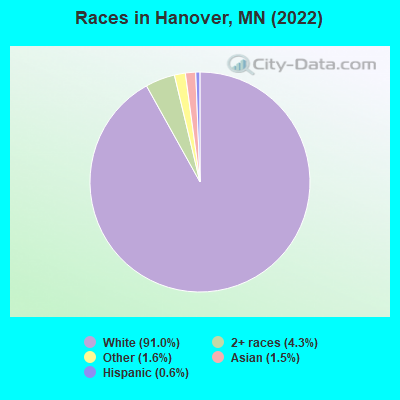
- 3,26391.0%White alone
- 1544.3%Two or more races
- 571.6%Other race alone
- 541.5%Asian alone
- 230.6%Hispanic
- 10.03%Black alone
Races in Hanover detailed stats: ancestries, foreign born residents, place of birth
 Recent articles from our blog. Our writers, many of them Ph.D. graduates or candidates, create easy-to-read articles on a wide variety of topics.

 | Minneapolis-St. Paul Ranked #4th Snobbiest City. (556 replies) |
| why dont they build more public transportation to more suburbs (178 replies) |
| Hobby Farm/Sustainable Living (13 replies) |
| Cost of Living in Minneapolis vs midwest (82 replies) |
| Please demystify the burbs for me! (especially SW) (6 replies) |
| Small Towns in St. Paul or Minneapolis Area? Pop 2000 (6 replies) |
Latest news from Hanover, MN collected exclusively by city-data.com from local newspapers, TV, and radio stations
Hanover, MN City Guides:
Ancestries: American (21.4%), German (18.8%), Norwegian (7.8%), European (5.6%), Irish (5.5%), Scandinavian (5.2%).
Current Local Time: CST time zone
Elevation: 930 feet
Land area: 4.89 square miles.
Population density: 770 people per square mile (low).
68 residents are foreign born
| This city: | 1.9% |
| Minnesota: | 8.5% |
Median real estate property taxes paid for housing units with mortgages in 2022: $4,417 (1.0%)
Median real estate property taxes paid for housing units with no mortgage in 2022: $4,724 (1.1%)
Nearest city with pop. 50,000+: Maple Grove, MN  (10.8 miles , pop. 50,365).
Nearest city with pop. 200,000+: Minneapolis, MN (23.6 miles , pop. 382,618).
Nearest city with pop. 1,000,000+: Chicago, IL (377.8 miles , pop. 2,896,016).
Nearest cities:
), Latitude: 45.16 N, Longitude: 93.66 W

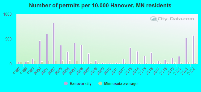
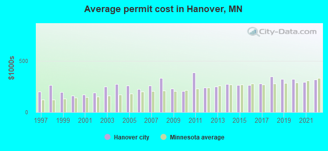
Single-family new house construction building permits:
- 2022: 78 buildings, average cost: $316,100
- 2021: 70 buildings, average cost: $294,400
- 2020: 21 buildings, average cost: $321,400
- 2019: 16 buildings, average cost: $320,200
- 2018: 12 buildings, average cost: $346,000
- 2017: 8 buildings, average cost: $279,700
- 2016: 31 buildings, average cost: $263,400
- 2015: 22 buildings, average cost: $262,900
- 2014: 34 buildings, average cost: $272,800
- 2013: 44 buildings, average cost: $246,800
- 2012: 13 buildings, average cost: $238,000
- 2011: 3 buildings, average cost: $384,300
- 2010: 2 buildings, average cost: $206,800
- 2009: 3 buildings, average cost: $228,000
- 2008: 9 buildings, average cost: $331,500
- 2007: 28 buildings, average cost: $260,400
- 2006: 52 buildings, average cost: $224,700
- 2005: 57 buildings, average cost: $259,900
- 2004: 33 buildings, average cost: $275,200
- 2003: 51 buildings, average cost: $250,600
- 2002: 112 buildings, average cost: $188,600
- 2001: 82 buildings, average cost: $169,500
- 2000: 64 buildings, average cost: $160,000
- 1999: 14 buildings, average cost: $196,200
- 1998: 5 buildings, average cost: $262,100
- 1997: 6 buildings, average cost: $200,000
| Here: | 2.8% |
| Minnesota: | 2.6% |
- Construction (9.8%)
- Health care (8.1%)
- Finance & insurance (6.4%)
- Professional, scientific, technical services (5.6%)
- Metal & metal products (5.1%)
- Educational services (4.3%)
- Accommodation & food services (3.9%)
- Construction (15.9%)
- Metal & metal products (6.7%)
- Professional, scientific, technical services (6.2%)
- Finance & insurance (5.2%)
- Administrative & support & waste management services (4.0%)
- Machinery (3.7%)
- Miscellaneous manufacturing (3.7%)
- Health care (16.2%)
- Finance & insurance (7.7%)
- Accommodation & food services (6.0%)
- Social assistance (6.0%)
- Educational services (5.8%)
- Professional, scientific, technical services (4.9%)
- Administrative & support & waste management services (3.6%)
- Other sales and related occupations, including supervisors (5.2%)
- Other office and administrative support workers, including supervisors (5.2%)
- Computer specialists (4.6%)
- Secretaries and administrative assistants (4.0%)
- Other production occupations, including supervisors (4.0%)
- Sales representatives, services, wholesale and manufacturing (3.7%)
- Registered nurses (3.4%)
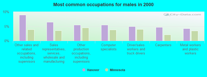
- Other sales and related occupations, including supervisors (8.9%)
- Sales representatives, services, wholesale and manufacturing (6.5%)
- Other production occupations, including supervisors (5.5%)
- Computer specialists (5.5%)
- Driver/sales workers and truck drivers (5.0%)
- Carpenters (4.7%)
- Metal workers and plastic workers (4.2%)

- Other office and administrative support workers, including supervisors (9.3%)
- Secretaries and administrative assistants (8.5%)
- Registered nurses (7.1%)
- Accountants and auditors (4.1%)
- Other healthcare support occupations (3.8%)
- Computer specialists (3.6%)
- Information and record clerks, except customer service representatives (3.6%)
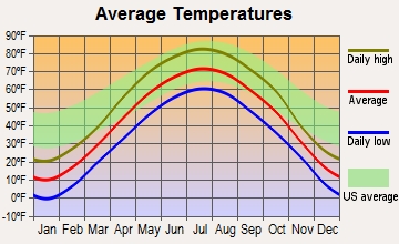
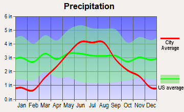
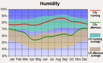
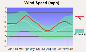
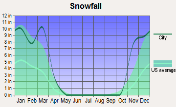
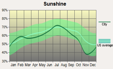
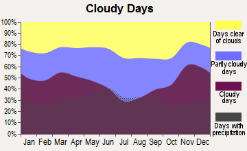
Average climate in Hanover, Minnesota
Based on data reported by over 4,000 weather stations
|
|


(lower is better)
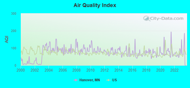
Air Quality Index (AQI) level in 2022 was 65.4. This is about average.
| City: | 65.4 |
| U.S.: | 72.6 |
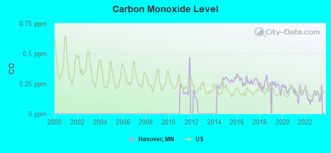
Carbon Monoxide (CO) [ppm] level in 2022 was 0.144. This is significantly better than average. Closest monitor was 22.2 miles away from the city center.
| City: | 0.144 |
| U.S.: | 0.251 |
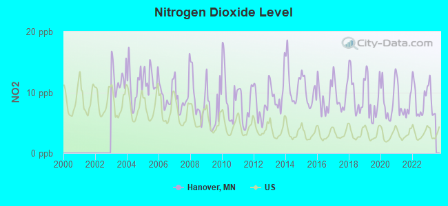
Nitrogen Dioxide (NO2) [ppb] level in 2022 was 8.73. This is significantly worse than average. Closest monitor was 10.7 miles away from the city center.
| City: | 8.73 |
| U.S.: | 5.11 |
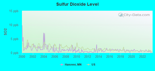
Sulfur Dioxide (SO2) [ppb] level in 2022 was 0.667. This is significantly better than average. Closest monitor was 10.4 miles away from the city center.
| City: | 0.667 |
| U.S.: | 1.515 |
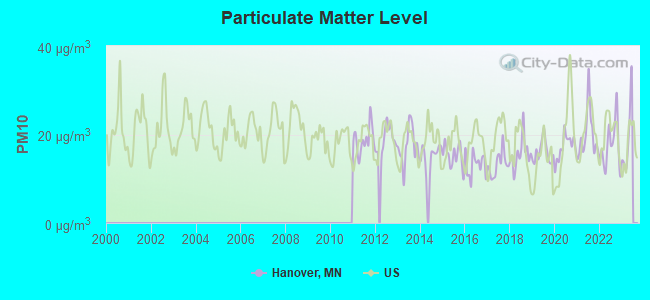
Particulate Matter (PM10) [µg/m3] level in 2022 was 17.4. This is about average. Closest monitor was 3.2 miles away from the city center.
| City: | 17.4 |
| U.S.: | 19.2 |
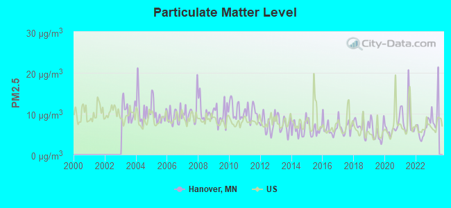
Particulate Matter (PM2.5) [µg/m3] level in 2022 was 6.20. This is better than average. Closest monitor was 3.2 miles away from the city center.
| City: | 6.20 |
| U.S.: | 8.11 |
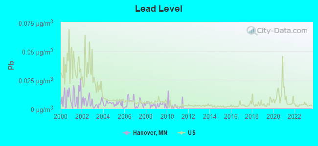
Lead (Pb) [µg/m3] level in 2010 was 0.00275. This is significantly better than average. Closest monitor was 12.9 miles away from the city center.
| City: | 0.00275 |
| U.S.: | 0.00931 |
Tornado activity:
Hanover-area historical tornado activity is slightly above Minnesota state average. It is 22% greater than the overall U.S. average.
On 5/6/1965, a category F4 (max. wind speeds 207-260 mph) tornado 13.8 miles away from the Hanover city center killed 3 people and injured 175 people and caused between $5,000,000 and $50,000,000 in damages.
On 6/19/1951, a category F4 tornado 15.6 miles away from the city center killed one person and injured 20 people and caused between $500,000 and $5,000,000 in damages.
Earthquake activity:
Hanover-area historical earthquake activity is significantly above Minnesota state average. It is 52% smaller than the overall U.S. average.On 7/9/1975 at 14:54:15, a magnitude 4.6 (4.6 MB, Class: Light, Intensity: IV - V) earthquake occurred 120.7 miles away from Hanover center
On 6/5/1993 at 01:24:53, a magnitude 4.1 (4.1 LG, Depth: 6.2 mi) earthquake occurred 132.6 miles away from the city center
On 3/4/1983 at 06:32:18, a magnitude 4.6 (4.4 MB, 4.6 LG, 4.4 ML) earthquake occurred 290.1 miles away from Hanover center
On 10/20/1995 at 15:57:18, a magnitude 3.7 (3.7 LG, Depth: 3.1 mi, Class: Light, Intensity: II - III) earthquake occurred 161.2 miles away from Hanover center
On 2/9/1994 at 08:45:35, a magnitude 3.1 (3.1 LG, Depth: 3.1 mi) earthquake occurred 66.4 miles away from Hanover center
On 11/3/2002 at 20:41:56, a magnitude 4.3 (4.3 MB, Depth: 3.1 mi) earthquake occurred 308.7 miles away from Hanover center
Magnitude types: regional Lg-wave magnitude (LG), body-wave magnitude (MB), local magnitude (ML)
Natural disasters:
The number of natural disasters in Wright County (16) is near the US average (15).Major Disasters (Presidential) Declared: 12
Emergencies Declared: 3
Causes of natural disasters: Floods: 12, Storms: 6, Tornadoes: 3, Blizzard: 1, Drought: 1, Hurricane: 1, Landslide: 1, Mudslide: 1, Wind: 1, Winter Storm: 1, Other: 1 (Note: some incidents may be assigned to more than one category).

Hospitals and medical centers near Hanover:
- DCI DOUGLAS (Hospital, about 9 miles away; BUFFALO, MN)
- HAMMER LAWNDALE (Hospital, about 10 miles away; MAPLE GROVE, MN)
- PARK VIEW CARE CENTER (Nursing Home, about 11 miles away; BUFFALO, MN)
- RETIREMENT CENTER OF WRIGHT COUNTY (Nursing Home, about 11 miles away; BUFFALO, MN)
- BUFFALO HOSPITAL Acute Care Hospitals (about 11 miles away; BUFFALO, MN)
- FMC DIALYSIS - BUFFALO (Dialysis Facility, about 11 miles away; BUFFALO, MN)
- DCI 75TH (Hospital, about 11 miles away; MAPLE GROVE, MN)
Operable nuclear power plant near Hanover:
- 12 miles: Monticello in Monticello, MN.
Colleges/universities with over 2000 students nearest to Hanover:
- Hennepin Technical College (about 14 miles; Brooklyn Park, MN; Full-time enrollment: 4,515)
- North Hennepin Community College (about 15 miles; Brooklyn Park, MN; FT enrollment: 4,943)
- Anoka-Ramsey Community College (about 16 miles; Coon Rapids, MN; FT enrollment: 5,918)
- Minneapolis Community and Technical College (about 23 miles; Minneapolis, MN; FT enrollment: 6,726)
- Walden University (about 24 miles; Minneapolis, MN; FT enrollment: 62,473)
- Capella University (about 24 miles; Minneapolis, MN; FT enrollment: 21,718)
- University of Minnesota-Twin Cities (about 25 miles; Minneapolis, MN; FT enrollment: 43,506)
Public elementary/middle school in Hanover:
- HANOVER ELEMENTARY (Location: 274 LABEAUXE AVE NE, Grades: KG-5)
Points of interest:
Notable locations in Hanover: Hanover Fire Department (A), Hanover City Hall (B). Display/hide their locations on the map
Church in Hanover: Zion Church (A). Display/hide its location on the map
Park in Hanover: Riverside County Park (1). Display/hide its location on the map
| This city: | 3.2 people |
| Minnesota: | 2.5 people |
| This city: | 87.1% |
| Whole state: | 64.6% |
| This city: | 5.5% |
| Whole state: | 6.9% |
Likely homosexual households (counted as self-reported same-sex unmarried-partner households)
- Lesbian couples: 0.2% of all households
- Gay men: 0.0% of all households
Banks with branches in Hanover (2011 data):
- BANKWEST: Hanover Branch at 11000 River Road Northeast, branch established on 1992/09/14. Info updated 2006/11/03: Bank assets: $104.2 mil, Deposits: $95.3 mil, headquarters in Rockford, MN, negative income in the last year, Commercial Lending Specialization, 3 total offices, Holding Company: Bankwest Financial, Inc.
For population 15 years and over in Hanover:
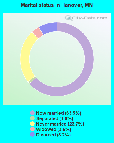
- Never married: 23.7%
- Now married: 63.5%
- Separated: 1.0%
- Widowed: 3.6%
- Divorced: 8.2%
For population 25 years and over in Hanover:
- High school or higher: 98.6%
- Bachelor's degree or higher: 48.4%
- Graduate or professional degree: 11.8%
- Unemployed: 0.9%
- Mean travel time to work (commute): 26.8 minutes
| Here: | 7.4 |
| Minnesota average: | 10.9 |
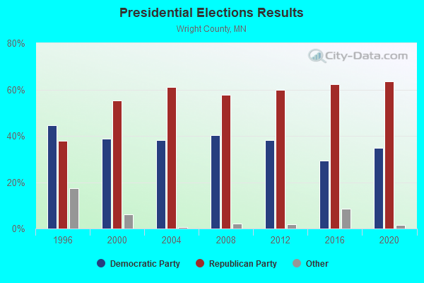
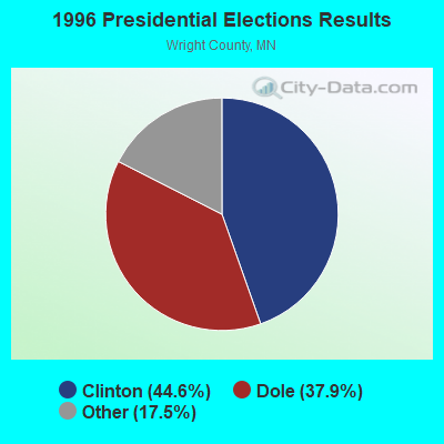
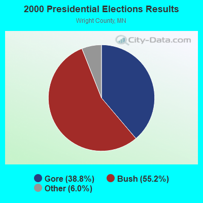
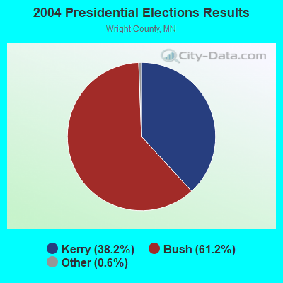
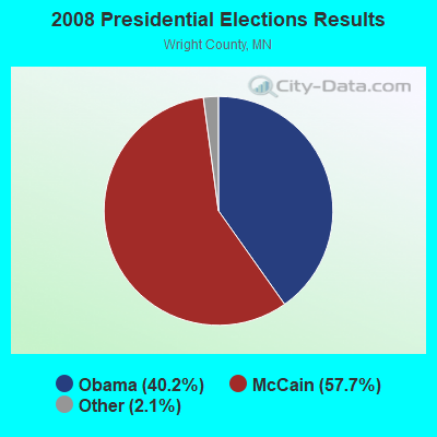
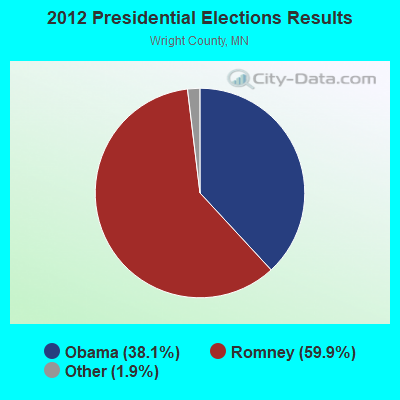
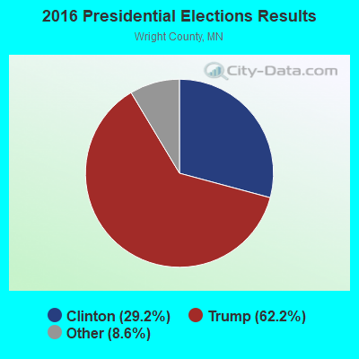
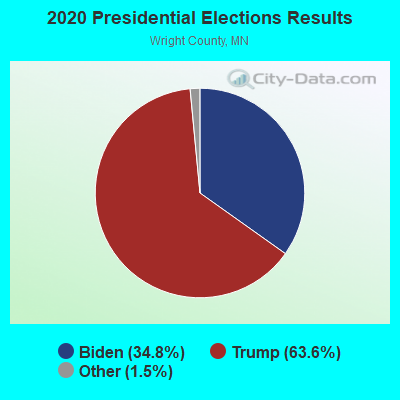
Graphs represent county-level data. Detailed 2008 Election Results
Religion statistics for Hanover, MN (based on Wright County data)
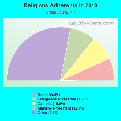
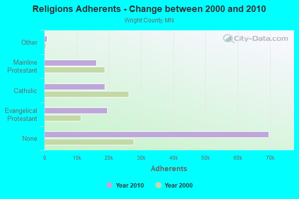
| Religion | Adherents | Congregations |
|---|---|---|
| Evangelical Protestant | 19,494 | 56 |
| Catholic | 18,699 | 13 |
| Mainline Protestant | 16,143 | 28 |
| Other | 715 | 5 |
| None | 69,649 | - |
Food Environment Statistics:
| Wright County: | 1.28 / 10,000 pop. |
| State: | 1.83 / 10,000 pop. |
| This county: | 0.09 / 10,000 pop. |
| State: | 0.13 / 10,000 pop. |
| Here: | 0.34 / 10,000 pop. |
| Minnesota: | 0.49 / 10,000 pop. |
| Wright County: | 3.59 / 10,000 pop. |
| Minnesota: | 3.90 / 10,000 pop. |
| Wright County: | 6.16 / 10,000 pop. |
| Minnesota: | 6.98 / 10,000 pop. |
| Here: | 5.3% |
| Minnesota: | 6.5% |
| This county: | 26.6% |
| State: | 25.9% |
| Wright County: | 9.9% |
| Minnesota: | 13.0% |
Health and Nutrition:
| Here: | 47.6% |
| State: | 50.6% |
| This city: | 46.5% |
| Minnesota: | 48.4% |
| Hanover: | 29.2 |
| Minnesota: | 28.5 |
| Hanover: | 26.7% |
| Minnesota: | 21.0% |
| Hanover: | 5.5% |
| Minnesota: | 9.8% |
| Hanover: | 6.7 |
| Minnesota: | 6.8 |
| This city: | 35.6% |
| Minnesota: | 33.5% |
| Here: | 58.3% |
| Minnesota: | 57.7% |
| Here: | 78.8% |
| State: | 79.3% |
More about Health and Nutrition of Hanover, MN Residents
| Local government employment and payroll (March 2022) | |||||
| Function | Full-time employees | Monthly full-time payroll | Average yearly full-time wage | Part-time employees | Monthly part-time payroll |
|---|---|---|---|---|---|
| Other Government Administration | 7 | $25,256 | $43,296 | 0 | $0 |
| Streets and Highways | 3 | $14,439 | $57,756 | 2 | $740 |
| Financial Administration | 1 | $5,361 | $64,332 | 0 | $0 |
| Firefighters | 0 | $0 | 30 | $13,514 | |
| Totals for Government | 11 | $45,056 | $49,152 | 32 | $14,254 |
Hanover government finances - Expenditure in 2018 (per resident):
- Construction - Regular Highways: $55,000 ($14.59)
- Current Operations - Sewerage: $400,000 ($106.13)
Regular Highways: $379,000 ($100.56)
General - Other: $326,000 ($86.50)
Financial Administration: $226,000 ($59.96)
Police Protection: $224,000 ($59.43)
Local Fire Protection: $182,000 ($48.29)
Water Utilities: $142,000 ($37.68)
Solid Waste Management: $38,000 ($10.08)
Central Staff Services: $31,000 ($8.22)
Parks and Recreation: $27,000 ($7.16)
Libraries: $11,000 ($2.92)
- General - Interest on Debt: $108,000 ($28.65)
- Other Capital Outlay - Regular Highways: $1,869,000 ($495.89)
Local Fire Protection: $116,000 ($30.78)
Parks and Recreation: $86,000 ($22.82)
General - Other: $30,000 ($7.96)
Hanover government finances - Revenue in 2018 (per resident):
- Charges - Sewerage: $362,000 ($96.05)
Other: $119,000 ($31.57)
Parks and Recreation: $13,000 ($3.45)
Regular Highways: $10,000 ($2.65)
Solid Waste Management: $7,000 ($1.86)
Miscellaneous Commercial Activities: $6,000 ($1.59)
- Miscellaneous - General Revenue - Other: $85,000 ($22.55)
Special Assessments: $64,000 ($16.98)
Interest Earnings: $50,000 ($13.27)
Fines and Forfeits: $5,000 ($1.33)
- Revenue - Water Utilities: $83,000 ($22.02)
- State Intergovernmental - General Local Government Support: $110,000 ($29.19)
Other: $49,000 ($13.00)
Highways: $25,000 ($6.63)
- Tax - Property: $1,547,000 ($410.45)
Other License: $97,000 ($25.74)
Public Utilities Sales: $16,000 ($4.25)
Severance: $8,000 ($2.12)
Hanover government finances - Debt in 2018 (per resident):
- Long Term Debt - Beginning Outstanding - Unspecified Public Purpose: $2,711,000 ($719.29)
Outstanding Unspecified Public Purpose: $2,325,000 ($616.87)
Retired Unspecified Public Purpose: $386,000 ($102.41)
Hanover government finances - Cash and Securities in 2018 (per resident):
- Other Funds - Cash and Securities: $1,317,000 ($349.43)
- Sinking Funds - Cash and Securities: $2,750,000 ($729.64)
Strongest AM radio stations in Hanover:
- WCCO (830 AM; 50 kW; MINNEAPOLIS, MN; Owner: INFINITY MEDIA CORPORATION)
- KSTP (1500 AM; 50 kW; ST. PAUL, MN; Owner: KSTP-AM, LLC (DELAWARE))
- KFAN (1130 AM; 50 kW; MINNEAPOLIS, MN; Owner: AMFM RADIO LICENSES, L.L.C.)
- WCTS (1030 AM; 50 kW; MAPLEWOOD, MN; Owner: CNTL. BAPT. THEO/AL SEMI MINNEAPOLIS)
- KTIS (900 AM; 25 kW; MINNEAPOLIS, MN; Owner: NORTHWESTERN COLLEGE)
- KLBP (1470 AM; 5 kW; BROOKLYN PARK, MN; Owner: 1400, INC.)
- KWOM (1600 AM; 5 kW; WATERTOWN, MN; Owner: WATERTOWN RADIO, INC.)
- WBHR (660 AM; 10 kW; SAUK RAPIDS, MN; Owner: HERBERT M. HOPPE)
- WWTC (1280 AM; 5 kW; MINNEAPOLIS, MN; Owner: SCA LICENSE CORPORATION)
- KDIZ (1440 AM; 5 kW; GOLDEN VALLEY, MN; Owner: KQRS, INC.)
- KUOM (770 AM; daytime; 5 kW; MINNEAPOLIS, MN)
- KSMM (1530 AM; 9 kW; SHAKOPEE, MN; Owner: STARBOARD BROADCASTING, INC.)
- WMNN (1330 AM; 10 kW; MINNEAPOLIS, MN; Owner: MINNESOTA PUBLIC RADIO.)
Strongest FM radio stations in Hanover:
- KQQL (107.9 FM; ANOKA, MN; Owner: AMFM RADIO LICENSES, L.L.C.)
- KTCZ-FM (97.1 FM; MINNEAPOLIS, MN; Owner: AMFM RADIO LICENSES, L.L.C.)
- KJZI (100.3 FM; MINNEAPOLIS, MN; Owner: AMFM RADIO LICENSES, L.L.C.)
- KNOW-FM (91.1 FM; MINNEAPOLIS-ST. PAUL, MN; Owner: MINNESOTA PUBLIC RADIO)
- WLTE (102.9 FM; MINNEAPOLIS, MN; Owner: INFINITY MEDIA CORPORATION)
- KSTP-FM (94.5 FM; ST. PAUL, MN; Owner: KSTP-FM, LLC, A DELAWARE LLC)
- KLCI (106.1 FM; ELK RIVER, MN; Owner: MILESTONE RADIO LLC)
- KEEY-FM (102.1 FM; ST. PAUL, MN; Owner: AMFM RADIO LICENSES, L.L.C.)
- KTIS-FM (98.5 FM; MINNEAPOLIS, MN; Owner: NORTHWESTERN COLLEGE)
- KDWB-FM (101.3 FM; RICHFIELD, MN; Owner: AMFM RADIO LICENSES, L.L.C.)
- KQRS-FM (92.5 FM; GOLDEN VALLEY, MN; Owner: KQRS, Inc.)
- KSJN (99.5 FM; MINNEAPOLIS, MN; Owner: MINNESOTA PUBLIC RADIO)
- KXXR (93.7 FM; MINNEAPOLIS, MN; Owner: KQRS, INC.)
- KTTB (96.3 FM; GLENCOE, MN; Owner: BLUE CHIP BROADCASTING LICENSES II, LTD.)
- K214DF (90.7 FM; GOLDEN VALLEY, MN; Owner: EDUCATIONAL MEDIA FOUNDATION)
- KCLD-FM (104.7 FM; ST. CLOUD, MN; Owner: LEIGHTON ENTERPRISES, INC.)
- WFMP (107.1 FM; COON RAPIDS, MN; Owner: WFMP-FM, LLC)
- KFAI (90.3 FM; MINNEAPOLIS, MN; Owner: FRESH AIR, INC.)
- KBEM-FM (88.5 FM; MINNEAPOLIS, MN; Owner: BD. OF EDUCATION, S.S.D. NO. 1)
- WGVZ (105.7 FM; EDEN PRAIRIE, MN; Owner: KQRS, INC.)
TV broadcast stations around Hanover:
- KPXM (Channel 41; ST. CLOUD, MN; Owner: PAXSON MINNEAPOLIS LICENSE, INC.)
- KARE (Channel 11; MINNEAPOLIS, MN; Owner: MULTIMEDIA HOLDINGS CORPORATION)
- KSTP-TV (Channel 5; ST. PAUL, MN; Owner: HUBBARD BROADCASTING, INC.)
- KMSP-TV (Channel 9; MINNEAPOLIS, MN; Owner: FOX TELEVISION STATIONS, INC.)
- KTCA-TV (Channel 2; ST. PAUL, MN; Owner: TWIN CITIES PUBLIC TELEVISION, INC.)
- WCCO-TV (Channel 4; MINNEAPOLIS, MN; Owner: CBS BROADCASTING INC.)
- KSTC-TV (Channel 45; MINNEAPOLIS, MN; Owner: HUBBARD BROADCASTING, INC.)
- KTCI-TV (Channel 17; ST. PAUL, MN; Owner: TWIN CITIES PUBLIC TELEVISION, INC.)
- K07UI (Channel 7; MINNEAPOLIS, ETC., MN; Owner: WORD OF GOD FELLOWSHIP, INC.)
- KMWB (Channel 23; MINNEAPOLIS, MN; Owner: KLGT LICENSEE, LLC)
- WFTC (Channel 29; MINNEAPOLIS, MN; Owner: FOX TELEVISION STATIONS, INC.)
- K58BS (Channel 58; MINNEAPOLIS, MN; Owner: TRINITY BROADCASTING NETWORK)
- K67HG (Channel 67; MINNEAPOLIS, MN; Owner: VENTANA TELEVISION, INC.)
- K19ER (Channel 19; ST. PAUL, MN; Owner: CATHOLIC VIEWS BROADCASTS, INC.)
- K14KH (Channel 14; MINNEAPOLIS, MN; Owner: THREE ANGELS BROADCASTING NETWORK)
- W62BD (Channel 62; MINNEAPOLIS, MN; Owner: WORD OF GOD FELLOWSHIP, INC.)
- WBWX-CA (Channel 13; MINNEAPOLIS, MN; Owner: THE BOX WORLDWIDE LLC)
Hanover fatal accident list:
Apr 6, 1988 06:47 PM, 19, Vehicles: 2, Persons: 4, Fatalities: 1, Drunk persons involved: 2
- National Bridge Inventory (NBI) Statistics
- 1Number of bridges
- 26ft / 7.7mTotal length
- 11,600Total average daily traffic
- 11,600Total future (year 2039) average daily traffic
FCC Registered Antenna Towers:
9 (See the full list of FCC Registered Antenna Towers in Hanover)FCC Registered Microwave Towers:
1- A1O0182B, 11440 8th St. Ne (Lat: 45.162583 Lon: -93.660139), Type: Mtower, Structure height: 45.7 m, Call Sign: WQQB706,
Assigned Frequencies: 11265.0 MHz, 11265.0 MHz, 11265.0 MHz, 11265.0 MHz, 11265.0 MHz, 11265.0 MHz, 11265.0 MHz, 11265.0 MHz, 11265.0 MHz, 11265.0 MHz, Grant Date: 12/06/2022, Expiration Date: 10/17/2032, Cancellation Date: 07/03/2023, Certifier: Dan Menser, Registrant: T-Mobile Usa, Inc., 12920 Se 38th Street, Bellevue, WA 98006, Phone: (425) 383-8401, Email:
FCC Registered Amateur Radio Licenses:
3- Call Sign: KD0NXG, Licensee ID: L01624690, Grant Date: 03/15/2011, Expiration Date: 03/15/2021, Cancellation Date: 03/16/2023, Certifier: William D Arthur, Registrant: William D Arthur, 11854 Riverview Rd Ne, Hanover, MN 55341
- Call Sign: KD0RPQ, Licensee ID: L01702894, Grant Date: 01/19/2022, Expiration Date: 04/13/2032, Certifier: Keith H Gross, Registrant: Keith H Gross, 11910 9th St Ne, Hanover, MN 55341
- Call Sign: KM6JWC, Licensee ID: L02096044, Grant Date: 04/10/2017, Expiration Date: 04/10/2027, Certifier: Colton K Kratky, Registrant: Colton K Kratky, 11510 Riverview Rd Ne, Hanover, MN 55341
FAA Registered Aircraft:
5- Aircraft: MOONEY M20J (Category: Land, Seats: 4, Weight: Up to 12,499 Pounds, Speed: 126 mph), Engine: LYCOMING I0360 SER (180 HP) (Reciprocating)
N-Number: 201TV, N201TV, N-201TV, Serial Number: 24-0332, Year manufactured: 1977, Airworthiness Date: 09/30/1977, Certificate Issue Date: 07/18/2001
Registrant (Individual): Robert J Hiivala, 10295 4th St Ne, Hanover, MN 55341 - Aircraft: CESSNA 206H (Category: Land, Seats: 6, Weight: Up to 12,499 Pounds), Engine: LYCOMING IO-540 SER (300 HP) (Reciprocating)
N-Number: 239MS, N239MS, N-239MS, Serial Number: 20608034, Airworthiness Date: 06/08/1999, Certificate Issue Date: 07/24/2003
Registrant (Individual): Michael C Schmitt, 10717 Settlers Ln, Hanover, MN 55341 - Aircraft: PIPER J3C-65 (Category: Land, Seats: 2, Weight: Up to 12,499 Pounds, Speed: 67 mph), Engine: CONT MOTOR A-65-8F (65 HP) (Reciprocating)
N-Number: 3460K, N3460K, N-3460K, Serial Number: 22151, Year manufactured: 1946, Airworthiness Date: 12/09/2019, Certificate Issue Date: 10/02/1997
Registrant (Individual): Thomas C Saba, 10520 Ann Cir, Hanover, MN 55341 - Aircraft: PIPER PA-16 (Category: Land, Seats: 4, Weight: Up to 12,499 Pounds, Speed: 87 mph), Engine: LYCOMING 0-235 SERIES (115 HP) (Reciprocating)
N-Number: 5610H, N5610H, N-5610H, Serial Number: 16-217, Year manufactured: 1949, Airworthiness Date: 08/15/1956, Certificate Issue Date: 07/17/2018
Registrant (Individual): Christopher R Reese, 10672 Jonquil Ln, Hanover, MN 55341 - Aircraft: CESSNA T210N (Category: Land, Seats: 6, Weight: Up to 12,499 Pounds), Engine: CONT MOTOR TSIO-520 SER (300 HP) (Reciprocating)
N-Number: 673DK, N673DK, N-673DK, Serial Number: 21063479, Year manufactured: 1979, Airworthiness Date: 07/06/1979, Certificate Issue Date: 04/23/2008
Registrant (LLC): Bh Aero LLC, 737 Jansen Ave Se, Hanover, MN 55341
2002 - 2018 National Fire Incident Reporting System (NFIRS) incidents
- Fire incident types reported to NFIRS in Hanover, MN
- 9447.0%Structure Fires
- 7437.0%Outside Fires
- 2211.0%Mobile Property/Vehicle Fires
- 105.0%Other
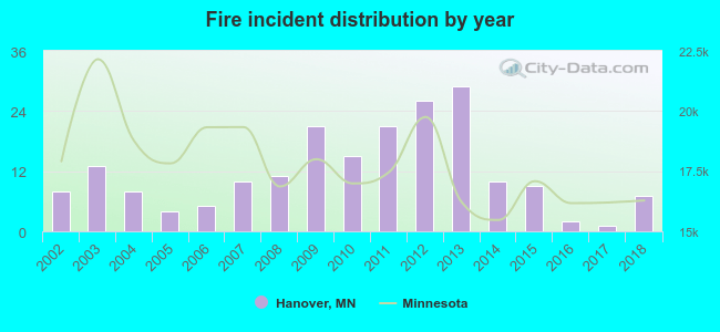 Based on the data from the years 2002 - 2018 the average number of fires per year is 12. The highest number of fires - 29 took place in 2013, and the least - 1 in 2017. The data has a declining trend.
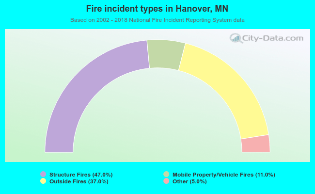 When looking into fire subcategories, the most incidents belonged to: Structure Fires (47.0%), and Outside Fires (37.0%).
| Most common first names in Hanover, MN among deceased individuals | ||
| Name | Count | Lived (average) |
|---|---|---|
| George | 3 | 87.0 years |
| William | 3 | 77.7 years |
| Robert | 3 | 82.0 years |
| Herman | 2 | 78.0 years |
| Harold | 2 | 76.0 years |
| Alma | 2 | 90.5 years |
| Dorothy | 2 | 77.5 years |
| Phyllis | 2 | 83.5 years |
| John | 2 | 71.0 years |
| Laura | 2 | 79.5 years |
| Most common last names in Hanover, MN among deceased individuals | ||
| Last name | Count | Lived (average) |
|---|---|---|
| Bechtold | 6 | 70.8 years |
| Kottke | 4 | 72.0 years |
| Ende | 3 | 71.7 years |
| Anderson | 2 | 78.5 years |
| Georges | 2 | 81.0 years |
| Feickert | 2 | 71.0 years |
| Friesen | 2 | 72.5 years |
| Lamb | 2 | 81.0 years |
| Kaunzner | 2 | 62.5 years |
| Dahl | 2 | 83.5 years |
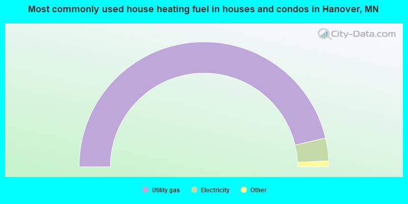
- 92.7%Utility gas
- 5.9%Electricity
- 1.0%Wood
- 0.4%Bottled, tank, or LP gas
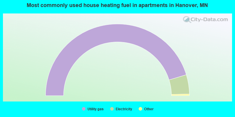
- 91.2%Utility gas
- 8.8%Electricity
Hanover compared to Minnesota state average:
- Median household income above state average.
- Unemployed percentage significantly below state average.
- Black race population percentage significantly below state average.
- Hispanic race population percentage significantly below state average.
- Median age significantly below state average.
- Foreign-born population percentage below state average.
- Renting percentage significantly below state average.
- Length of stay since moving in significantly above state average.
- Number of rooms per house above state average.
- House age significantly below state average.
- Number of college students above state average.
- Percentage of population with a bachelor's degree or higher above state average.
Hanover on our top lists:
- #93 on the list of "Top 100 cities with highest median household income and median resident age less than 35"
- #47 on the list of "Top 101 counties with the lowest number of deaths per 1000 residents 2007-2013 (pop. 50,000+)"
- #90 on the list of "Top 101 counties with the lowest percentage of residents relocating to foreign countries in 2011"
- #94 on the list of "Top 101 counties with the largest number of children under 18 without health insurance coverage in 2000 (pop. 50,000+)"

|
|
Total of 105 patent applications in 2008-2024.