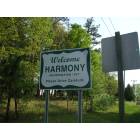
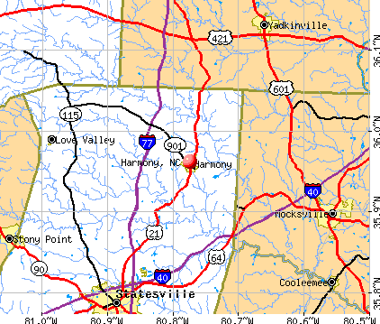
Harmony, North Carolina
Submit your own pictures of this town and show them to the world
- OSM Map
- General Map
- Google Map
- MSN Map
Population change since 2000: +8.4%
 |
| Males: 328 | |
| Females: 242 |
| Median resident age: | 41.6 years |
| North Carolina median age: | 39.2 years |
Zip codes: 28634.
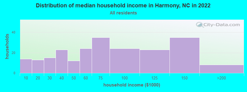
| Harmony: | $61,040 |
| NC: | $67,481 |
Estimated per capita income in 2022: $27,447 (it was $15,591 in 2000)
Harmony town income, earnings, and wages data
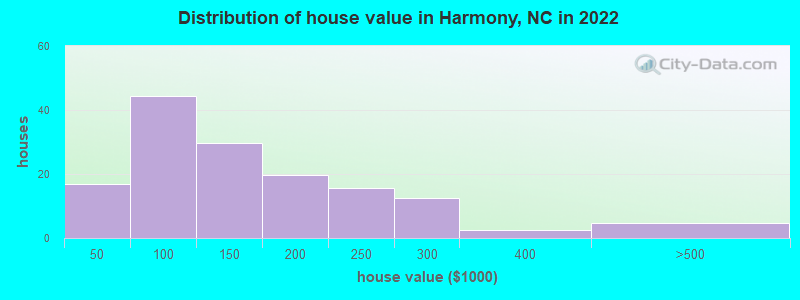
Estimated median house or condo value in 2022: $150,275 (it was $80,000 in 2000)
| Harmony: | $150,275 |
| NC: | $280,600 |
Mean prices in 2022: all housing units: $165,579; detached houses: $164,863; mobile homes: $154,020
Median gross rent in 2022: $989.
(7.1% for White Non-Hispanic residents, 6.4% for Hispanic or Latino residents, 19.0% for two or more races residents)
Detailed information about poverty and poor residents in Harmony, NC
Compare current foreclosures near Harmony, NC:
| Photo | Address | Area | Beds / Baths | Price | Details |
|---|---|---|---|---|---|

|
#1
Reavis Rd
Harmony, NC 28634
|
1,333 sq. feet
|
1 baths 3 beds |
show details | |

|
#2
Pishner Dr
Harmony, NC 28634
|
1,782 sq. feet
|
2 baths 3 beds |
show details | |

|
#3
Harmony Hwy
Harmony, NC 28634
|
- sq. feet
|
- baths - beds |
show details | |

|
#4
Kimmon Rd
Harmony, NC 28634
|
- sq. feet
|
- baths - beds |
show details | |

|
#5
E Memorial Hwy
Harmony, NC 28634
|
- sq. feet
|
- baths - beds |
show details | |

|
#6
Dear Marlon Ln
Harmony, NC 28634
|
- sq. feet
|
- baths - beds |
show details | |

|
#7
Harmony Blend Dr
Harmony, NC 28634
|
- sq. feet
|
- baths - beds |
show details | |

|
#8
Wood St
Statesville, NC 28677
|
1,304 sq. feet
|
1 baths 3 beds |
show details | |

|
#9
Us Highway 64 W
Mocksville, NC 27028
|
1,970 sq. feet
|
2 baths 3 beds |
show details | |

|
#10
Big Forest Dr
Statesville, NC 28677
|
1,428 sq. feet
|
2 baths 3 beds |
show details |
| Photo | Address | Area | Beds / Baths | Price | Details |
|---|---|---|---|---|---|

|
#11
Wilkesboro Hwy
Statesville, NC 28625
|
1,152 sq. feet
|
2 baths 3 beds |
show details | |

|
#12
Queens Ct
Statesville, NC 28677
|
1,570 sq. feet
|
2 baths 3 beds |
show details | |

|
#13
Ramie Mitchell Rd
Hiddenite, NC 28636
|
1,960 sq. feet
|
2 baths 3 beds |
show details | |

|
#14
Porter Rd
Statesville, NC 28625
|
1,593 sq. feet
|
1 baths 3 beds |
show details | |

|
#15
Junction Rd
Mocksville, NC 27028
|
1,680 sq. feet
|
2 baths 3 beds |
show details | |

|
#16
Dove Meadow Ln
Statesville, NC 28625
|
1,491 sq. feet
|
2 baths 3 beds |
show details | |

|
#17
Berkshire Dr
Statesville, NC 28677
|
1,984 sq. feet
|
2 baths 4 beds |
show details | |

|
#18
Stoneybrook Rd
Statesville, NC 28677
|
4,013 sq. feet
|
3 baths 3 beds |
show details | |

|
#19
Crest Dr
Statesville, NC 28625
|
1,404 sq. feet
|
2 baths 3 beds |
show details | |

|
#20
Park St
Statesville, NC 28677
|
1,024 sq. feet
|
1 baths 2 beds |
show details |
| Photo | Address | Area | Beds / Baths | Price | Details |
|---|---|---|---|---|---|

|
#21
Winding Creek Rd
Mocksville, NC 27028
|
2,948 sq. feet
|
2 baths 3 beds |
show details | |

|
#22
Antler Dr
Statesville, NC 28625
|
1,288 sq. feet
|
2 baths 3 beds |
show details | |

|
#23
Fawn Ln
Mocksville, NC 27028
|
760 sq. feet
|
1 baths 3 beds |
show details | |

|
#24
Spring St
Yadkinville, NC 27055
|
1,323 sq. feet
|
2 baths 3 beds |
show details | |

|
#25
Westwood Dr
Statesville, NC 28677
|
1,015 sq. feet
|
1 baths 2 beds |
show details | |

|
#26
Old Us 421 Hwy W
Yadkinville, NC 27055
|
1,276 sq. feet
|
1 baths 3 beds |
show details | |

|
#27
Northmont Dr
Statesville, NC 28625
|
2,958 sq. feet
|
2 baths 3 beds |
show details | |

|
#28
Boulder Pl
Statesville, NC 28625
|
1,058 sq. feet
|
2 baths 3 beds |
show details | |

|
#29
Us Hwy 601 S
Mocksville, NC 27028
|
1,192 sq. feet
|
1 baths 2 beds |
show details | |

|
#30
Sherwood Ln
Statesville, NC 28677
|
3,102 sq. feet
|
3 baths 4 beds |
show details |
| Photo | Address | Area | Beds / Baths | Price | Details |
|---|---|---|---|---|---|

|
#31
S Carolina Ave
Statesville, NC 28677
|
1,726 sq. feet
|
2 baths 3 beds |
show details | |

|
#32
Harmony Dr
Statesville, NC 28677
|
1,725 sq. feet
|
2 baths 3 beds |
show details | |

|
#33
Little Farm Rd
Statesville, NC 28625
|
1,904 sq. feet
|
2 baths 3 beds |
show details | |

|
#34
Country Club Rd
Yadkinville, NC 27055
|
1,083 sq. feet
|
1 baths 2 beds |
show details | |

|
#35
Island Ford Rd
Statesville, NC 28625
|
1,562 sq. feet
|
2 baths 2 beds |
show details | |

|
#36
Bethesda Rd
Statesville, NC 28677
|
2,128 sq. feet
|
2 baths 4 beds |
show details | |

|
#37
Us 601 Hwy
Yadkinville, NC 27055
|
1,834 sq. feet
|
2 baths 3 beds |
show details | |

|
#38
History Ln
Statesville, NC 28677
|
2,205 sq. feet
|
2 baths 4 beds |
show details | |

|
#39
Bridge Mill Ct
Statesville, NC 28625
|
1,404 sq. feet
|
2 baths 3 beds |
show details | |

|
#40
Hartford Ln
Mocksville, NC 27028
|
1,364 sq. feet
|
2 baths 3 beds |
show details |
| Photo | Address | Area | Beds / Baths | Price | Details |
|---|---|---|---|---|---|

|
#41
Antietam Rd
Statesville, NC 28625
|
1,767 sq. feet
|
2 baths 3 beds |
show details | |

|
#42
Hatford Ct
Statesville, NC 28625
|
1,668 sq. feet
|
2 baths 3 beds |
show details | |

|
#43
Milling Rd
Mocksville, NC 27028
|
2,240 sq. feet
|
2 baths 3 beds |
show details | |

|
#44
Red Walnut Dr
Statesville, NC 28677
|
1,568 sq. feet
|
2 baths 3 beds |
show details | |

|
#45
Sain Rd
Mocksville, NC 27028
|
1,848 sq. feet
|
2 baths 3 beds |
show details | |

|
#46
Thompson Ln
Statesville, NC 28625
|
2,168 sq. feet
|
2 baths 3 beds |
show details | |

|
#47
Wall St
Statesville, NC 28677
|
1,512 sq. feet
|
2 baths 3 beds |
show details | |

|
#48
Covenant Cove Dr
Mocksville, NC 27028
|
1,992 sq. feet
|
3 baths 3 beds |
show details | |

|
#49
Hope St
Statesville, NC 28677
|
832 sq. feet
|
1 baths 2 beds |
show details | |

|
Check over 1 million property listings on Foreclosure.com!
|
browse all offers | |||


- 46576.4%White alone
- 12019.7%Hispanic
- 152.5%Black alone
- 91.5%Two or more races
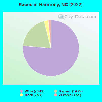
Races in Harmony detailed stats: ancestries, foreign born residents, place of birth
According to our research of North Carolina and other state lists, there were 12 registered sex offenders living in Harmony, North Carolina as of May 17, 2024.
The ratio of all residents to sex offenders in Harmony is 45 to 1.
 Recent articles from our blog. Our writers, many of them Ph.D. graduates or candidates, create easy-to-read articles on a wide variety of topics.

 | buying home in Harmony subdivision, Pulte homes. (12 replies) |
| purchasing a resale home in the Harmony subdivision in Cary,NC by Pulte (1 reply) |
| Google Fiber starts up Charlotte service! Who will switch? (58 replies) |
| Raleigh Wedding Planner (7 replies) |
| Harmony Glen (6 replies) |
| Are we in a new bubble or are home prices finally reaching 2006 prices? (100 replies) |
Latest news from Harmony, NC collected exclusively by city-data.com from local newspapers, TV, and radio stations
Ancestries: American (19.9%), English (18.6%), German (15.9%), European (5.8%), Scottish (3.1%), Scotch-Irish (2.7%).
Current Local Time: EST time zone
Elevation: 991 feet
Land area: 1.38 square miles.
Population density: 412 people per square mile (low).
42 residents are foreign born (6.7% Latin America).
| This town: | 6.9% |
| North Carolina: | 8.3% |
Median real estate property taxes paid for housing units with mortgages in 2022: $717 (0.4%)
Median real estate property taxes paid for housing units with no mortgage in 2022: $775 (0.7%)
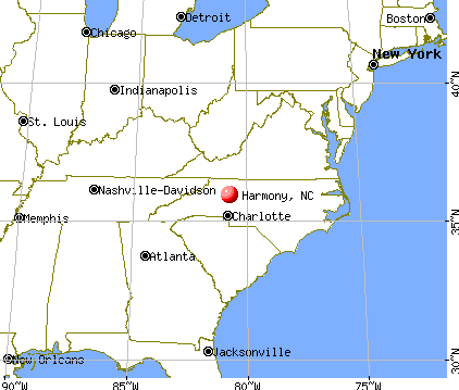
Nearest city with pop. 50,000+: Winston-Salem, NC  (30.3 miles , pop. 185,776).
Nearest city with pop. 200,000+: Charlotte, NC (52.3 miles , pop. 540,828).
Nearest city with pop. 1,000,000+: Philadelphia, PA (414.7 miles , pop. 1,517,550).
Nearest cities:
), )Latitude: 35.96 N, Longitude: 80.77 W
Area code: 704
Property values in Harmony, NC

| Here: | 3.0% |
| North Carolina: | 3.2% |
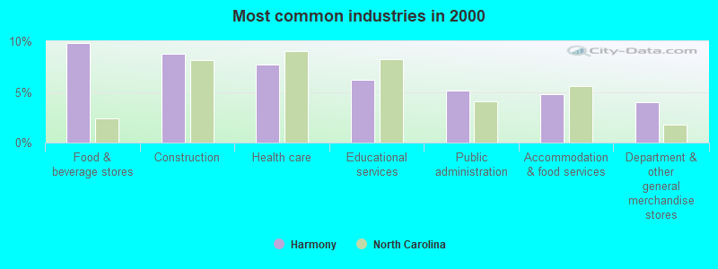
- Food & beverage stores (9.9%)
- Construction (8.8%)
- Health care (7.7%)
- Educational services (6.2%)
- Public administration (5.1%)
- Accommodation & food services (4.7%)
- Department & other general merchandise stores (4.0%)
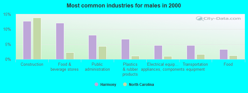
- Construction (12.8%)
- Food & beverage stores (12.1%)
- Public administration (8.1%)
- Plastics & rubber products (6.7%)
- Electrical equipment, appliances, components (4.7%)
- Transportation equipment (4.7%)
- Food (3.4%)
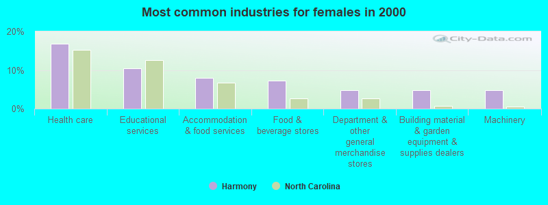
- Health care (16.8%)
- Educational services (10.4%)
- Accommodation & food services (8.0%)
- Food & beverage stores (7.2%)
- Department & other general merchandise stores (4.8%)
- Building material & garden equipment & supplies dealers (4.8%)
- Machinery (4.8%)
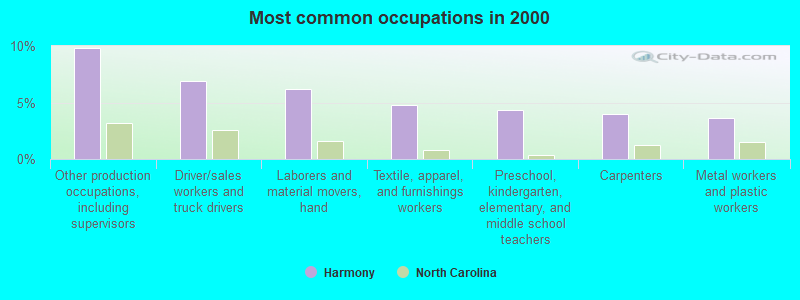
- Other production occupations, including supervisors (9.9%)
- Driver/sales workers and truck drivers (6.9%)
- Laborers and material movers, hand (6.2%)
- Textile, apparel, and furnishings workers (4.7%)
- Preschool, kindergarten, elementary, and middle school teachers (4.4%)
- Carpenters (4.0%)
- Metal workers and plastic workers (3.6%)
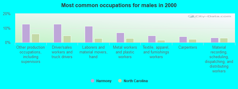
- Other production occupations, including supervisors (12.8%)
- Driver/sales workers and truck drivers (12.8%)
- Laborers and material movers, hand (11.4%)
- Metal workers and plastic workers (6.7%)
- Textile, apparel, and furnishings workers (4.7%)
- Carpenters (4.0%)
- Material recording, scheduling, dispatching, and distributing workers (3.4%)
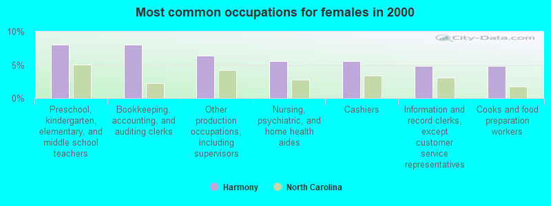
- Preschool, kindergarten, elementary, and middle school teachers (8.0%)
- Bookkeeping, accounting, and auditing clerks (8.0%)
- Other production occupations, including supervisors (6.4%)
- Nursing, psychiatric, and home health aides (5.6%)
- Cashiers (5.6%)
- Information and record clerks, except customer service representatives (4.8%)
- Cooks and food preparation workers (4.8%)
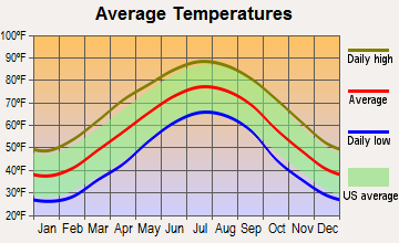
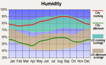
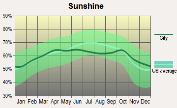
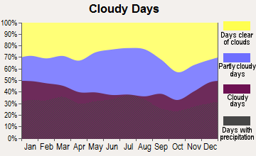
Average climate in Harmony, North Carolina
Based on data reported by over 4,000 weather stations


(lower is better)
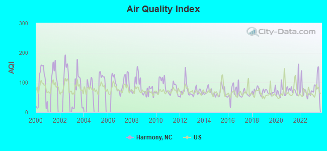
Air Quality Index (AQI) level in 2023 was 92.3. This is worse than average.
| City: | 92.3 |
| U.S.: | 72.6 |
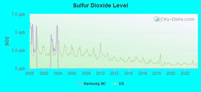
Sulfur Dioxide (SO2) [ppb] level in 2003 was 3.62. This is significantly worse than average. Closest monitor was 15.1 miles away from the city center.
| City: | 3.62 |
| U.S.: | 1.51 |
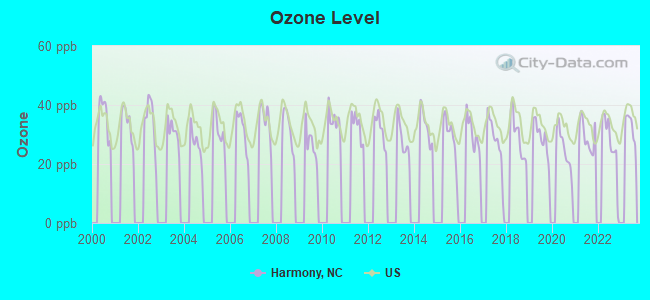
Ozone [ppb] level in 2022 was 26.9. This is better than average. Closest monitor was 12.9 miles away from the city center.
| City: | 26.9 |
| U.S.: | 33.3 |
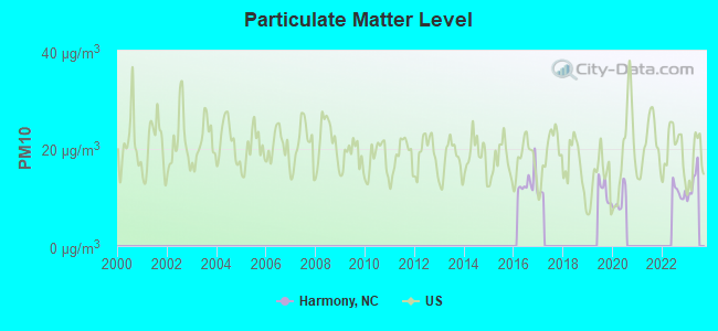
Particulate Matter (PM10) [µg/m3] level in 2022 was 11.3. This is significantly better than average. Closest monitor was 20.4 miles away from the city center.
| City: | 11.3 |
| U.S.: | 19.2 |
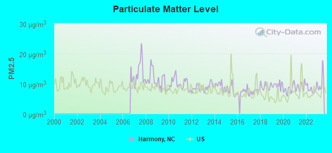
Particulate Matter (PM2.5) [µg/m3] level in 2023 was 10.4. This is worse than average. Closest monitor was 24.6 miles away from the city center.
| City: | 10.4 |
| U.S.: | 8.1 |
Tornado activity:
Harmony-area historical tornado activity is slightly below North Carolina state average. It is 23% smaller than the overall U.S. average.
On 5/7/1998, a category F4 (max. wind speeds 207-260 mph) tornado 31.2 miles away from the Harmony town center injured 2 people and caused $1 million in damages.
On 5/5/1989, a category F4 tornado 41.1 miles away from the town center killed 4 people and injured 52 people and caused between $5,000,000 and $50,000,000 in damages.
Earthquake activity:
Harmony-area historical earthquake activity is significantly above North Carolina state average. It is 16% smaller than the overall U.S. average.On 8/9/2020 at 12:07:37, a magnitude 5.1 (5.1 MW, Depth: 4.7 mi, Class: Moderate, Intensity: VI - VII) earthquake occurred 39.8 miles away from the city center
On 8/23/2011 at 17:51:04, a magnitude 5.8 (5.8 MW, Depth: 3.7 mi) earthquake occurred 206.8 miles away from Harmony center
On 8/2/1974 at 08:52:09, a magnitude 4.9 (4.3 MB, 4.9 LG, Class: Light, Intensity: IV - V) earthquake occurred 174.2 miles away from Harmony center
On 7/27/1980 at 18:52:21, a magnitude 5.2 (5.1 MB, 4.7 MS, 5.0 UK, 5.2 UK) earthquake occurred 233.8 miles away from the city center
On 11/30/1973 at 07:48:41, a magnitude 4.7 (4.7 MB, 4.6 ML) earthquake occurred 179.0 miles away from the city center
On 11/23/2006 at 10:42:57, a magnitude 4.3 (4.3 MB) earthquake occurred 106.2 miles away from Harmony center
Magnitude types: regional Lg-wave magnitude (LG), body-wave magnitude (MB), local magnitude (ML), surface-wave magnitude (MS), moment magnitude (MW)
Natural disasters:
The number of natural disasters in Iredell County (13) is near the US average (15).Major Disasters (Presidential) Declared: 7
Emergencies Declared: 4
Causes of natural disasters: Droughts: 2, Floods: 2, Hurricanes: 2, Storms: 2, Tropical Storms: 2, Blizzard: 1, Freeze: 1, Ice Storm: 1, Snowfall: 1, Tornado: 1, Winter Storm: 1, Other: 1 (Note: some incidents may be assigned to more than one category).

Hospitals and medical centers near Harmony:
- YADKIN I (Hospital, about 12 miles away; HAMPTONVILLE, NC)
- HOSPICE OF IREDELL COUNTY (Hospital, about 12 miles away; STATESVILLE, NC)
- HOLLINGSWOOD GROUP HOME (Hospital, about 12 miles away; STATESVILLE, NC)
- DAVIE COUNTY HOSPITAL Critical Access Hospitals (about 13 miles away; MOCKSVILLE, NC)
- DAVIE COUNTY HOME HEALTH AGENC (Home Health Center, about 13 miles away; MOCKSVILLE, NC)
- IREDELL HOME HEALTH (Home Health Center, about 13 miles away; STATESVILLE, NC)
- BRIAN CENTER HEALTH AND REHABILITATION/STATESVILLE (Nursing Home, about 13 miles away; STATESVILLE, NC)
Airports located in Harmony:
- Schneider Haven Airstrip Airport (NC75) (Runways: 1)
Colleges/universities with over 2000 students nearest to Harmony:
- Mitchell Community College (about 15 miles; Statesville, NC; Full-time enrollment: 2,458)
- NASCAR Technical Institute (about 26 miles; Mooresville, NC; FT enrollment: 2,350)
- Wilkes Community College (about 26 miles; Wilkesboro, NC; FT enrollment: 2,292)
- Rowan-Cabarrus Community College (about 28 miles; Salisbury, NC; FT enrollment: 5,749)
- Forsyth Technical Community College (about 30 miles; Winston Salem, NC; FT enrollment: 7,190)
- Surry Community College (about 30 miles; Dobson, NC; FT enrollment: 2,686)
- Wake Forest University (about 31 miles; Winston Salem, NC; FT enrollment: 6,407)
Public elementary/middle school in Harmony:
- HARMONY ELEMENTARY (Location: 139 HARMONY SCHOOL ROAD, Grades: PK-5)
Points of interest:
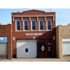
Notable location: Harmony Fire Department (A). Display/hide its location on the map
Birthplace of: Roger Sharpe - Politician.
Drinking water stations with addresses in Harmony and their reported violations in the past:
FRIENDSHIP BAPTIST CHURCH (Population served: 35, Groundwater):Past monitoring violations:GUNTER`S COUNTRY STORE (Address: 2328 SANDY SPRINGS RD , Population served: 25, Groundwater):
- One regular monitoring violation
Past monitoring violations:
- 11 routine major monitoring violations
- 2 regular monitoring violations
| This town: | 2.6 people |
| North Carolina: | 2.5 people |
| This town: | 70.4% |
| Whole state: | 66.7% |
| This town: | 6.3% |
| Whole state: | 5.9% |
Likely homosexual households (counted as self-reported same-sex unmarried-partner households)
- Lesbian couples: 0.5% of all households
- Gay men: 0.0% of all households
Banks with branches in Harmony (2011 data):
- First Bank: Harmony Branch at 3364 Harmony Highway, branch established on 1956/10/24. Info updated 2011/01/25: Bank assets: $3,289.4 mil, Deposits: $2,759.1 mil, headquarters in Troy, NC, positive income, Commercial Lending Specialization, 98 total offices, Holding Company: First Bancorp
For population 15 years and over in Harmony:
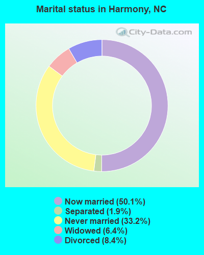
- Never married: 33.2%
- Now married: 50.1%
- Separated: 1.9%
- Widowed: 6.4%
- Divorced: 8.4%
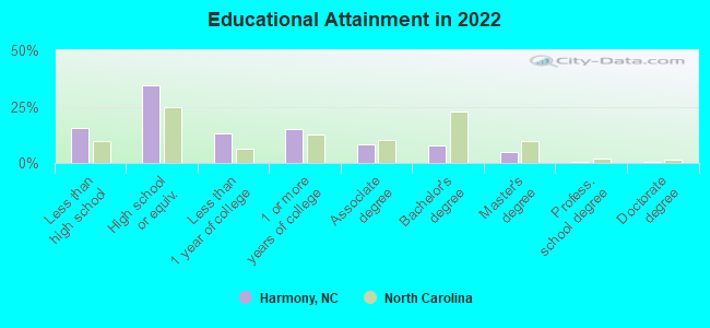
For population 25 years and over in Harmony:
- High school or higher: 82.6%
- Bachelor's degree or higher: 13.1%
- Graduate or professional degree: 5.6%
- Unemployed: 2.5%
- Mean travel time to work (commute): 24.0 minutes
| Here: | 9.7 |
| North Carolina average: | 11.7 |
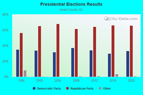
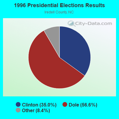


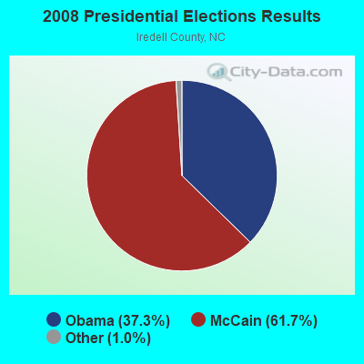
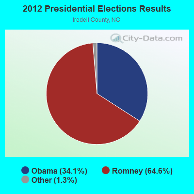
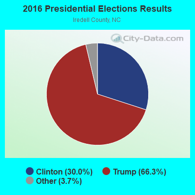

Graphs represent county-level data. Detailed 2008 Election Results
Religion statistics for Harmony, NC (based on Iredell County data)
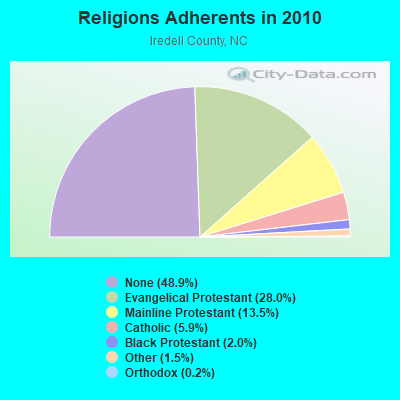
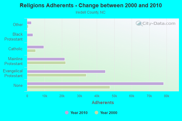
| Religion | Adherents | Congregations |
|---|---|---|
| Evangelical Protestant | 44,803 | 156 |
| Mainline Protestant | 21,637 | 78 |
| Catholic | 9,487 | 2 |
| Black Protestant | 3,250 | 18 |
| Other | 2,352 | 8 |
| Orthodox | 360 | 1 |
| None | 78,301 | - |
Food Environment Statistics:
| Here: | 1.52 / 10,000 pop. |
| North Carolina: | 2.05 / 10,000 pop. |
| Iredell County: | 0.20 / 10,000 pop. |
| North Carolina: | 0.14 / 10,000 pop. |
| This county: | 0.46 / 10,000 pop. |
| State: | 0.92 / 10,000 pop. |
| Iredell County: | 5.56 / 10,000 pop. |
| North Carolina: | 4.75 / 10,000 pop. |
| Here: | 8.61 / 10,000 pop. |
| North Carolina: | 7.57 / 10,000 pop. |
| Iredell County: | 8.9% |
| North Carolina: | 9.8% |
| Here: | 26.8% |
| State: | 28.3% |
| Iredell County: | 13.6% |
| North Carolina: | 15.6% |
Health and Nutrition:
| Harmony: | 48.1% |
| North Carolina: | 48.9% |
| Here: | 44.3% |
| North Carolina: | 46.1% |
| Here: | 29.1 |
| State: | 28.8 |
| This city: | 22.8% |
| State: | 20.7% |
| Harmony: | 11.7% |
| North Carolina: | 10.7% |
| This city: | 6.8 |
| North Carolina: | 6.8 |
| Harmony: | 33.4% |
| State: | 33.7% |
| This city: | 55.4% |
| North Carolina: | 55.8% |
| Here: | 77.8% |
| State: | 79.7% |
More about Health and Nutrition of Harmony, NC Residents
| Local government employment and payroll (March 2022) | |||||
| Function | Full-time employees | Monthly full-time payroll | Average yearly full-time wage | Part-time employees | Monthly part-time payroll |
|---|---|---|---|---|---|
| Other Government Administration | 0 | $0 | 6 | $7,733 | |
| Financial Administration | 0 | $0 | 1 | $2,607 | |
| Totals for Government | 0 | $0 | 7 | $10,339 | |
Harmony government finances - Expenditure in 2017 (per resident):
- Current Operations - Central Staff Services: $167,000 ($292.98)
Water Utilities: $103,000 ($180.70)
Regular Highways: $100,000 ($175.44)
Solid Waste Management: $19,000 ($33.33)
- General - Interest on Debt: $10,000 ($17.54)
Harmony government finances - Revenue in 2017 (per resident):
- Charges - Sewerage: $159,000 ($278.95)
Miscellaneous Commercial Activities: $3,000 ($5.26)
- Miscellaneous - General Revenue - Other: $51,000 ($89.47)
Rents: $5,000 ($8.77)
Interest Earnings: $0 ($0.00)
- State Intergovernmental - General Local Government Support: $57,000 ($100.00)
Highways: $15,000 ($26.32)
- Tax - General Sales and Gross Receipts: $117,000 ($205.26)
Property: $31,000 ($54.39)
Harmony government finances - Debt in 2017 (per resident):
- Long Term Debt - Beginning Outstanding - Unspecified Public Purpose: $225,000 ($394.74)
Outstanding Unspecified Public Purpose: $222,000 ($389.47)
Retired Unspecified Public Purpose: $3,000 ($5.26)
Strongest AM radio stations in Harmony:
- WTRU (830 AM; 50 kW; KERNERSVILLE, NC; Owner: TRUTH BROADCASTING CORPORATION)
- WHKY (1290 AM; 50 kW; HICKORY, NC; Owner: LONG COMMUNICATIONS, LLC.)
- WSGH (1040 AM; 9 kW; LEWISVILLE, NC; Owner: WINSTON-SALEM, GREENSBORO, HIGH POINT AREA RADIO)
- WDSL (1520 AM; daytime; 5 kW; MOCKSVILLE, NC)
- WBT (1110 AM; 50 kW; CHARLOTTE, NC; Owner: JEFFERSON-PILOT COMMUNICATNS CO. OF NORTH CAROLINA)
- WSJS (600 AM; 5 kW; WINSTON-SALEM, NC)
- WCXN (1170 AM; daytime; 8 kW; CLAREMONT, NC; Owner: WCXN, INC.)
- WPAQ (740 AM; 10 kW; MOUNT AIRY, NC; Owner: RALPH D. EPPERSON)
- WFGW (1010 AM; 50 kW; BLACK MOUNTAIN, NC; Owner: BLUE RIDGE BROADCASTING CORP.)
- WQIS (1130 AM; 1 kW; CAMDEN, SC)
- WAME (550 AM; 0 kW; STATESVILLE, NC; Owner: STATESVILLE FAMILY RADIO CORPORATION)
- WPTF (680 AM; 50 kW; RALEIGH, NC; Owner: FIRST STATE COMMUNICATIONS)
- WLTC (1370 AM; 20 kW; GASTONIA, NC)
Strongest FM radio stations in Harmony:
- WFMX (105.7 FM; STATESVILLE, NC; Owner: MERCURY BROADCASTING COMPANY, INC.)
- WEND (106.5 FM; SALISBURY, NC; Owner: CAPSTAR TX LIMITED PARTNERSHIP)
- WKBC-FM (97.3 FM; NORTH WILKESBORO, NC; Owner: WILKES BROADCASTING COMPANY, INC.)
- WTHZ (94.1 FM; LEXINGTON, NC; Owner: DAVIDSON COUNTY BROADCASTING CO, INC)
- WIFM-FM (100.9 FM; ELKIN, NC; Owner: VON BROADCASTING, INC.)
- WBRF (98.1 FM; GALAX, VA; Owner: BLUE RIDGE RADIO, INC.)
- WTQR (104.1 FM; WINSTON-SALEM, NC; Owner: CLEAR CHANNEL BROADCASTING LICENSES, INC.)
- W285DJ (104.9 FM; MOUNT AIRY, NC; Owner: TRIAD FAMILY NETWORK, INC,)
- W267AN (101.3 FM; WILKESBORO, NC; Owner: TRIAD FAMILY NETWORK, INC.)
- WLYT (102.9 FM; HICKORY, NC; Owner: CAPSTAR TX LIMITED PARTNERSHIP)
- WPEG (97.9 FM; CONCORD, NC; Owner: INFINITY RADIO SUBSIDIARY OPERATIONS INC.)
- WLNK (107.9 FM; CHARLOTTE, NC; Owner: JEFFERSON-PILOT COMMUNICATIONS COMPANY OF NORTH CAROLINA)
- WNKS (95.1 FM; CHARLOTTE, NC; Owner: INFINITY RADIO SUBSIDIARY OPERATIONS INC.)
- WWMG (96.1 FM; SHELBY, NC; Owner: CLEAR CHANNEL BROADCASTING LICENSES, INC.)
- WFDD (88.5 FM; WINSTON-SALEM, NC; Owner: WAKE FOREST UNIVERSITY)
- WFAE (90.7 FM; CHARLOTTE, NC; Owner: UNIVERSITY RADIO FOUNDATION, INC.)
- WXRC (95.7 FM; HICKORY, NC; Owner: PACIFIC BROADCASTING GROUP, INC.)
- WKKT (96.9 FM; STATESVILLE, NC; Owner: CAPSTAR TX LIMITED PARTNERSHIP)
- WSOC-FM (103.7 FM; CHARLOTTE, NC; Owner: INFINITY RADIO SUBSIDIARY OPERATIONS INC.)
- WMAG (99.5 FM; HIGH POINT, NC; Owner: CAPSTAR TX LIMITED PARTNERSHIP)
TV broadcast stations around Harmony:
- WBTV (Channel 3; CHARLOTTE, NC; Owner: JEFFERSON-PILOT COMMUNICATIONS/WBTV, INC.)
- WFMY-TV (Channel 2; GREENSBORO, NC; Owner: WFMY TELEVISION CORPORATION)
- WAXN (Channel 64; KANNAPOLIS, NC; Owner: WSOC-TV HOLDINGS, INC.)
- WJZY (Channel 46; BELMONT, NC; Owner: WJZY-TV, INC.)
- WWWB (Channel 55; ROCK HILL, SC; Owner: WWWB-TV, INC.)
- WCNC-TV (Channel 36; CHARLOTTE, NC; Owner: WCNC-TV, INC.)
- W66BT (Channel 66; STATESVILLE, NC; Owner: TRINITY BROADCASTING NETWORK)
- WUPN-TV (Channel 48; GREENSBORO, NC; Owner: WUPN LICENSEE, LLC)
- WXLV-TV (Channel 45; WINSTON-SALEM, NC; Owner: WXLV LICENSEE, LLC)
- WUNG-TV (Channel 58; CONCORD, NC; Owner: UNIVERSITY OF NORTH CAROLINA)
- WTWB-TV (Channel 20; LEXINGTON, NC; Owner: WTWB OF THE TRIAD, LLC)
- WLXI-TV (Channel 61; GREENSBORO, NC; Owner: TRI-STATE CHRISTIAN TV, INC.)
- WAFF (Channel 48; HUNTSVILLE, AL; Owner: RAYCOM AMERICA, INC.)
- WTVI (Channel 42; CHARLOTTE, NC; Owner: CHARLOTTE-MECKLENBURG PUBLIC BROADCASTING AUTHORITY)
- WGTB-LP (Channel 28; CHARLOTTE, NC; Owner: VICTORY CHRISTIAN CENTER, INC.)
- Harmony, North Carolina
- Fatal accident count9
- Vehicles involved in fatal accidents13
- Fatal accidents involving drunk persons:5
- Fatalities10
- Persons involved in fatal accidents23
- Pedestrians involved in fatal accidents0
- North Carolina average
- Fatal accident count10422
- Vehicles involved in fatal accidents15720
- Fatal accidents involving drunk persons3838
- Fatalities11489
- Persons involved in fatal accidents26438
- Pedestrians involved in fatal accidents1114
- National Bridge Inventory (NBI) Statistics
- 29Number of bridges
- 315ft / 96.3mTotal length
- 21,790Total average daily traffic
- 1,371Total average daily truck traffic
- 43,580Total future (year 2040) average daily traffic
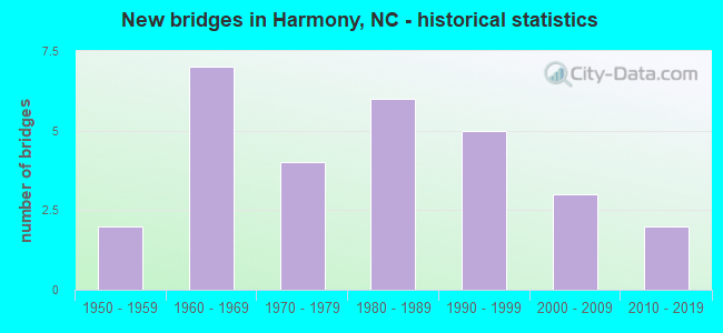
- New bridges - historical statistics
- 21950-1959
- 71960-1969
- 41970-1979
- 61980-1989
- 51990-1999
- 32000-2009
- 22010-2019
FCC Registered Cell Phone Towers:
2 (See the full list of FCC Registered Cell Phone Towers in Harmony)FCC Registered Antenna Towers:
25 (See the full list of FCC Registered Antenna Towers)FCC Registered Broadcast Land Mobile Towers:
2- Jct Nc 901 And Us 21 (Lat: 35.953750 Lon: -80.770889), Call Sign: KJD272,
Assigned Frequencies: 153.890 MHz, 154.385 MHz, Grant Date: 04/07/2022, Expiration Date: 06/08/2032, Registrant: Business Radio Licensing, 30251 Golden Lantern, Suite E #501, Laguna Niguel, CA 92677, Phone: (949) 348-8510, Fax: (949) 348-8514, Email:
- Us 21 And Nc 901 (Lat: 35.954306 Lon: -80.771167), Call Sign: WYZ450,
Assigned Frequencies: 155.160 MHz, Grant Date: 11/07/2023, Expiration Date: 01/30/2034, Registrant: Iredell County Emergency Communications, 404 Bristol Dr, Statesville, NC 28687, Phone: (704) 832-2183, Fax: (704) 878-3219, Email:
FCC Registered Microwave Towers:
4- Harmony ES, 139 Harmony School Road (Lat: 35.960667 Lon: -80.772972), Type: Tank, Structure height: 39.6 m, Overall height: 41.1 m, Call Sign: WQEB716,
Assigned Frequencies: 17920.0 MHz, Grant Date: 12/22/2005, Expiration Date: 12/22/2015, Cancellation Date: 02/27/2016, Certifier: Mark A Horinko, Registrant: Conterra Ultra Broadband, LLC, 2101 Rexford Rd Ste 200e, Charlotte, NC 28211, Phone: (704) 936-1777, Fax: (704) 936-1801, Email:
- Olin, Corner Of Olin Rd And Tatum Rd (Lat: 35.951667 Lon: -80.841111), Type: Tower, Structure height: 57.9 m, Overall height: 59.4 m, Call Sign: WQEY673,
Assigned Frequencies: 942.775 MHz, Grant Date: 03/02/2016, Expiration Date: 05/19/2026, Certifier: David W Martin, Registrant: Iredell County Emergency Communications, 404 Bristol Dr, Statesville, NC 28687, Phone: (704) 832-2183, Fax: (704) 878-3219, Email:
- CR73XC106, 131 Winthrop Road (Brooks Crossroads / 021106) (Lat: 36.006250 Lon: -80.824750), Type: Mast, Structure height: 76.2 m, Overall height: 77.7 m, Call Sign: WQQU680,
Assigned Frequencies: 10895.0 MHz, 11015.0 MHz, 11055.0 MHz, 10895.0 MHz, 11015.0 MHz, 11055.0 MHz, 10895.0 MHz, 11015.0 MHz, 11055.0 MHz, Grant Date: 03/05/2013, Expiration Date: 03/05/2023, Cancellation Date: 09/05/2014, Certifier: Kyle B Entz, Registrant: Sprint Nextel Corporation, 12502 Sunrise Valley Drive, Reston, VA 20196, Phone: (703) 433-4000, Fax: (703) 433-4483
- CR73XC106, 131 Winthrop Road (Brooks Crossroads / 021106) (Lat: 36.006250 Lon: -80.824750), Type: Mast, Structure height: 76.2 m, Overall height: 77.7 m, Call Sign: WQVC792,
Assigned Frequencies: 10895.0 MHz, 11015.0 MHz, 11055.0 MHz, 10895.0 MHz, 11015.0 MHz, 11055.0 MHz, 11015.0 MHz, 11055.0 MHz, 10895.0 MHz, Grant Date: 01/05/2015, Expiration Date: 01/05/2025, Cancellation Date: 05/11/2023, Certifier: Jenny Knopf, Registrant: T-Mobile Usa, Inc., 12920 Se 38th Street, Bellevue, WA 98006, Phone: (425) 383-8401, Email:
FCC Registered Amateur Radio Licenses:
18 (See the full list of FCC Registered Amateur Radio Licenses in Harmony)FAA Registered Aircraft:
4- Aircraft: PIPER PA-28-140 (Category: Land, Seats: 4, Weight: Up to 12,499 Pounds, Speed: 107 mph), Engine: LYCOMING 0-320 SERIES (180 HP) (Reciprocating)
N-Number: 1796T, N1796T, N-1796T, Serial Number: 28-7125135, Airworthiness Date: 05/11/1984, Certificate Issue Date: 11/03/2015
Registrant (Individual): John F Reavis, 431 Hamlet Rd, Harmony, NC 28634 - Aircraft: CESSNA 120 (Category: Land, Seats: 2, Weight: Up to 12,499 Pounds, Speed: 90 mph), Engine: CONT MOTOR C85 SERIES (85 HP) (Reciprocating)
N-Number: 72457, N72457, N-72457, Serial Number: 9622, Year manufactured: 1946, Airworthiness Date: 08/11/1955, Certificate Issue Date: 12/10/1999
Registrant (Individual): John F Reavis, 431 Hamlet Rd, Harmony, NC 28634 - Aircraft: CESSNA 182P (Category: Land, Seats: 4, Weight: Up to 12,499 Pounds, Speed: 120 mph), Engine: CONT MOTOR O-470 SERIES (230 HP) (Reciprocating)
N-Number: 773DS, N773DS, N-773DS, Serial Number: 18262402, Year manufactured: 1973, Airworthiness Date: 09/10/1973, Certificate Issue Date: 02/23/2007
Registrant (Individual): Donald R Shew, 300 Marshall Farm Rd, Harmony, NC 28634 - Aircraft: ERCOUPE 415-C (Category: Land, Seats: 2, Weight: Up to 12,499 Pounds, Speed: 90 mph), Engine: CONT MOTOR A&C75 SERIES (75 HP) (Reciprocating)
N-Number: 93685, N93685, N-93685, Serial Number: 1008, Year manufactured: 1946, Airworthiness Date: 05/11/1956, Certificate Issue Date: 05/16/2017
Registrant (Individual): David N Snow, 487 Kinder Rd, Harmony, NC 28634
2002 - 2018 National Fire Incident Reporting System (NFIRS) incidents
- Fire incident types reported to NFIRS in Harmony, NC
- 38351.2%Structure Fires
- 24532.8%Outside Fires
- 7810.4%Mobile Property/Vehicle Fires
- 425.6%Other
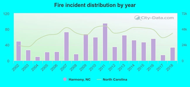 According to the data from the years 2002 - 2018 the average number of fires per year is 44. The highest number of fires - 95 took place in 2011, and the least - 10 in 2004. The data has a decreasing trend.
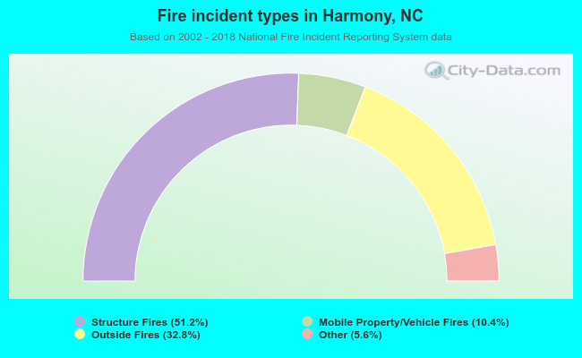 When looking into fire subcategories, the most incidents belonged to: Structure Fires (51.2%), and Outside Fires (32.8%).
| Most common first names in Harmony, NC among deceased individuals | ||
| Name | Count | Lived (average) |
|---|---|---|
| James | 47 | 71.3 years |
| William | 40 | 73.5 years |
| Mary | 33 | 81.8 years |
| John | 29 | 73.1 years |
| Robert | 24 | 68.9 years |
| Thomas | 16 | 75.2 years |
| George | 15 | 69.5 years |
| Charles | 14 | 70.9 years |
| Fred | 13 | 69.4 years |
| Richard | 12 | 67.0 years |
| Most common last names in Harmony, NC among deceased individuals | ||
| Last name | Count | Lived (average) |
|---|---|---|
| Campbell | 48 | 77.4 years |
| Smith | 32 | 78.7 years |
| Johnson | 32 | 65.0 years |
| Gaither | 24 | 74.5 years |
| Harris | 18 | 77.2 years |
| Templeton | 17 | 82.3 years |
| Sharpe | 15 | 72.7 years |
| York | 15 | 77.4 years |
| Reavis | 15 | 76.6 years |
| Stroud | 14 | 77.7 years |
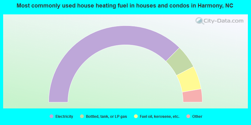
- 75.2%Electricity
- 9.9%Bottled, tank, or LP gas
- 9.9%Fuel oil, kerosene, etc.
- 3.7%Utility gas
- 1.2%Wood
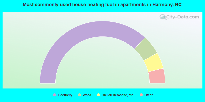
- 74.6%Electricity
- 10.2%Wood
- 8.5%Fuel oil, kerosene, etc.
- 3.4%Utility gas
- 3.4%Bottled, tank, or LP gas
Harmony compared to North Carolina state average:
- Median house value below state average.
- Unemployed percentage significantly below state average.
- Black race population percentage significantly below state average.
- Hispanic race population percentage above state average.
- Median age below state average.
- Length of stay since moving in significantly above state average.
- House age significantly above state average.
- Percentage of population with a bachelor's degree or higher below state average.
Harmony on our top lists:
- #44 on the list of "Top 101 cities with the most residents born in Other Central America (population 500+)"
- #11 on the list of "Top 101 counties with the largest decrease in the number of births per 1000 residents 2000-2006 to 2007-2013 (pop 50,000+)"
- #49 on the list of "Top 101 counties with the lowest percentage of residents relocating from foreign countries between 2010 and 2011"

|
Total of 12 patent applications in 2008-2024.