Hartford, Iowa
Submit your own pictures of this city and show them to the world
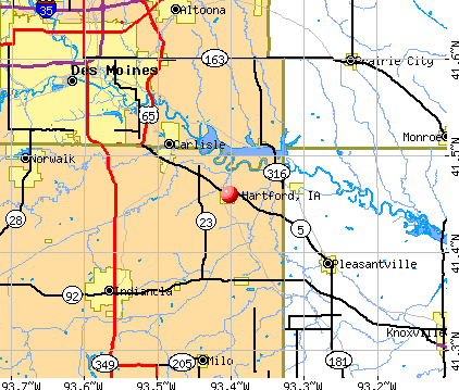
- OSM Map
- General Map
- Google Map
- MSN Map
Population change since 2000: -4.3%
 |
| Males: 385 | |
| Females: 341 |
| Median resident age: | 37.9 years |
| Iowa median age: | 38.9 years |
Zip codes: 50118.
| Hartford: | $70,637 |
| IA: | $69,588 |
Estimated per capita income in 2022: $33,003 (it was $18,141 in 2000)
Hartford city income, earnings, and wages data
Estimated median house or condo value in 2022: $159,559 (it was $73,000 in 2000)
| Hartford: | $159,559 |
| IA: | $194,600 |
Mean prices in 2022: all housing units: $149,510; detached houses: $199,144; mobile homes: $14,899
Median gross rent in 2022: $1,137.
Detailed information about poverty and poor residents in Hartford, IA
Compare current foreclosures near Hartford, IA:
| Photo | Address | Area | Beds / Baths | Price | Details |
|---|---|---|---|---|---|

|
#1
Jalea St
Hartford, IA 50118
|
1,005 sq. feet
|
1 baths 3 beds |
show details | |

|
#2
SW 5th St
Des Moines, IA 50315
|
730 sq. feet
|
1 baths 2 beds |
$169,900
|
show details |

|
#3
SE 8th St
Des Moines, IA 50315
|
1,008 sq. feet
|
1 baths 2 beds |
$224,900
|
show details |

|
#4
SW 13th St
Des Moines, IA 50315
|
620 sq. feet
|
1 baths 1 beds |
$144,900
|
show details |

|
#5
Easton Blvd
Des Moines, IA 50317
|
824 sq. feet
|
1 baths 2 beds |
$199,500
|
show details |

|
#6
E Diehl Ave
Des Moines, IA 50320
|
1,796 sq. feet
|
4 baths 5 beds |
$339,900
|
show details |

|
#7
W Salem Ave
Indianola, IA 50125
|
- sq. feet
|
1 baths 3 beds |
$147,000
|
show details |

|
#8
Cornell St
Des Moines, IA 50313
|
913 sq. feet
|
1 baths 2 beds |
show details | |

|
#9
Walnut Dr
Des Moines, IA 50327
|
969 sq. feet
|
1 baths 3 beds |
show details | |

|
#10
E Washington Ave
Des Moines, IA 50317
|
850 sq. feet
|
1 baths 2 beds |
show details |
| Photo | Address | Area | Beds / Baths | Price | Details |
|---|---|---|---|---|---|

|
#11
Chicago Ave
Des Moines, IA 50317
|
840 sq. feet
|
1 baths 3 beds |
show details | |

|
#12
S F St
Indianola, IA 50125
|
888 sq. feet
|
1 baths 3 beds |
show details | |

|
#13
E 23rd St
Des Moines, IA 50317
|
829 sq. feet
|
1 baths 2 beds |
show details | |

|
#14
Apple Ln
Indianola, IA 50125
|
1,258 sq. feet
|
2 baths 3 beds |
show details | |

|
#15
SE 8th Ct
Des Moines, IA 50315
|
1,036 sq. feet
|
2 baths 3 beds |
show details | |

|
#16
E Elm St
Milo, IA 50166
|
1,008 sq. feet
|
2 baths 3 beds |
show details | |

|
#17
N Park St
Prairie City, IA 50228
|
1,316 sq. feet
|
1 baths 4 beds |
show details | |

|
#18
Maple St
Des Moines, IA 50317
|
1,004 sq. feet
|
1 baths 3 beds |
show details | |

|
#19
3rd St
Des Moines, IA 50313
|
1,103 sq. feet
|
1 baths 3 beds |
show details | |

|
#20
Marion St
Prairie City, IA 50228
|
1,145 sq. feet
|
1 baths 2 beds |
show details |
| Photo | Address | Area | Beds / Baths | Price | Details |
|---|---|---|---|---|---|

|
#21
SW 7th St
Des Moines, IA 50315
|
856 sq. feet
|
1 baths 2 beds |
show details | |

|
#22
E 19th St
Des Moines, IA 50316
|
1,322 sq. feet
|
2 baths 3 beds |
show details | |

|
#23
E 21st St
Des Moines, IA 50317
|
616 sq. feet
|
1 baths 2 beds |
show details | |

|
#24
Elder Ln
Des Moines, IA 50315
|
980 sq. feet
|
1 baths 3 beds |
show details | |

|
#25
15th Ave SW
Altoona, IA 50009
|
1,456 sq. feet
|
2 baths 3 beds |
show details | |

|
#26
E 36th Ct
Des Moines, IA 50317
|
720 sq. feet
|
1 baths 2 beds |
show details | |

|
#27
Boulder Ave
Des Moines, IA 50315
|
998 sq. feet
|
1 baths 2 beds |
show details | |

|
#28
Shady Lane Dr
Norwalk, IA 50211
|
896 sq. feet
|
1 baths 3 beds |
show details | |

|
#29
E 27th Ct
Des Moines, IA 50317
|
960 sq. feet
|
1 baths 2 beds |
show details | |

|
#30
9th St SW
Altoona, IA 50009
|
1,881 sq. feet
|
2 baths 4 beds |
show details |
| Photo | Address | Area | Beds / Baths | Price | Details |
|---|---|---|---|---|---|

|
#31
Lyon St
Des Moines, IA 50317
|
1,078 sq. feet
|
1 baths 3 beds |
show details | |

|
#32
Elder Ln
Des Moines, IA 50315
|
980 sq. feet
|
1 baths 3 beds |
show details | |

|
#33
Emma Ave
Des Moines, IA 50315
|
1,124 sq. feet
|
1 baths 2 beds |
show details | |

|
#34
Boyd St
Des Moines, IA 50317
|
1,064 sq. feet
|
1 baths 3 beds |
show details | |

|
#35
Payton Ave
Des Moines, IA 50315
|
2,197 sq. feet
|
2 baths 4 beds |
show details | |

|
#36
E 39th Ct
Des Moines, IA 50317
|
1,412 sq. feet
|
1 baths 2 beds |
show details | |

|
#37
S 4th St
Carlisle, IA 50047
|
1,159 sq. feet
|
2 baths 3 beds |
show details | |

|
#38
S Union St
Des Moines, IA 50315
|
1,332 sq. feet
|
1 baths 3 beds |
show details | |

|
#39
Village Run Dr Unit 1101
Des Moines, IA 50317
|
1,428 sq. feet
|
1 baths 2 beds |
show details | |

|
#40
E Gray St
Des Moines, IA 50315
|
840 sq. feet
|
1 baths 2 beds |
show details |
| Photo | Address | Area | Beds / Baths | Price | Details |
|---|---|---|---|---|---|

|
#41
E 32nd St
Des Moines, IA 50317
|
866 sq. feet
|
1 baths 2 beds |
show details | |

|
#42
E Bell Ave
Des Moines, IA 50315
|
1,200 sq. feet
|
1 baths 3 beds |
show details | |

|
#43
E 25th Ct
Des Moines, IA 50317
|
1,140 sq. feet
|
1 baths 2 beds |
show details | |

|
#44
Des Moines St
Des Moines, IA 50317
|
768 sq. feet
|
1 baths 2 beds |
show details | |

|
#45
E 49th St
Des Moines, IA 50317
|
2,258 sq. feet
|
2 baths 3 beds |
show details | |

|
#46
Belmar Dr
Des Moines, IA 50317
|
1,150 sq. feet
|
1 baths 3 beds |
show details | |

|
#47
E 18th St
Des Moines, IA 50316
|
1,000 sq. feet
|
1 baths 3 beds |
show details | |

|
#48
Searle St
Des Moines, IA 50317
|
1,197 sq. feet
|
1 baths 3 beds |
show details | |

|
#49
28th St
Des Moines, IA 50311
|
1,282 sq. feet
|
2 baths 2 beds |
show details | |

|
Check over 1 million property listings on Foreclosure.com!
|
browse all offers | |||


- 61192.7%White alone
- 253.8%Hispanic
- 91.4%Two or more races
- 71.1%Asian alone

Races in Hartford detailed stats: ancestries, foreign born residents, place of birth
 Recent articles from our blog. Our writers, many of them Ph.D. graduates or candidates, create easy-to-read articles on a wide variety of topics.

 | Advice on a neighborhood (4 replies) |
| From Politico Magazine. The reawakening & emergence of Des Moines did not happen by accident (35 replies) |
| Good or Bad Area? (8 replies) |
| Well, who would have thought....Des Moines 5th best place to retire (28 replies) |
| SouthEastern Des Moines (11 replies) |
| Des Moines/Central Iowa insurance sector continues to grow (12 replies) |
Latest news from Hartford, IA collected exclusively by city-data.com from local newspapers, TV, and radio stations
Ancestries: German (28.3%), American (11.4%), Norwegian (10.8%), Irish (9.2%), Italian (5.7%), English (5.4%).
Current Local Time: CST time zone
Incorporated on 06/29/1913
Elevation: 870 feet
Land area: 0.97 square miles.
Population density: 745 people per square mile (low).
13 residents are foreign born
| This city: | 2.0% |
| Iowa: | 5.6% |
| Hartford city: | 1.6% ($1,153) |
| Iowa: | 1.3% ($1,077) |
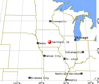
Nearest city with pop. 50,000+: Des Moines, IA  (14.5 miles , pop. 198,682).
Nearest city with pop. 200,000+: Omaha, NE (136.2 miles , pop. 390,007).
Nearest city with pop. 1,000,000+: Chicago, IL (296.9 miles , pop. 2,896,016).
Nearest cities:
), ), ), Latitude: 41.46 N, Longitude: 93.40 W
Area code commonly used in this area: 515


Single-family new house construction building permits:
- 2022: 1 building, cost: $225,800
- 2021: 1 building, cost: $360,400
- 2018: 2 buildings, average cost: $183,100
- 2017: 2 buildings, average cost: $246,700
- 2006: 12 buildings, average cost: $127,400
- 2005: 2 buildings, average cost: $117,400
- 2003: 3 buildings, average cost: $114,600
- 2002: 2 buildings, average cost: $107,300
- 2001: 2 buildings, average cost: $65,400
- 2000: 2 buildings, average cost: $76,600
- 1999: 1 building, cost: $42,100
- 1998: 1 building, cost: $42,100
- 1997: 1 building, cost: $139,600


| Here: | 2.4% |
| Iowa: | 2.7% |

- Finance & insurance (19.0%)
- Construction (11.4%)
- Health care (7.1%)
- Educational services (6.9%)
- Accommodation & food services (3.8%)
- Food & beverage stores (3.6%)
- Real estate & rental & leasing (3.6%)

- Construction (21.0%)
- Finance & insurance (7.3%)
- Health care (5.5%)
- Building material & garden equipment & supplies dealers (5.0%)
- Other transportation, support activities, couriers (4.1%)
- Air transportation (3.7%)
- Food & beverage stores (3.2%)

- Finance & insurance (31.5%)
- Educational services (11.3%)
- Health care (8.9%)
- Social assistance (6.4%)
- Real estate & rental & leasing (4.9%)
- Accommodation & food services (4.9%)
- Food & beverage stores (3.9%)

- Laborers and material movers, hand (8.1%)
- Other office and administrative support workers, including supervisors (4.7%)
- Bookkeeping, accounting, and auditing clerks (4.7%)
- Electrical equipment mechanics and other installation, maintenance, and repair workers, including supervisors (4.0%)
- Driver/sales workers and truck drivers (4.0%)
- Customer service representatives (3.8%)
- Secretaries and administrative assistants (3.3%)

- Laborers and material movers, hand (14.2%)
- Driver/sales workers and truck drivers (7.8%)
- Electrical equipment mechanics and other installation, maintenance, and repair workers, including supervisors (7.8%)
- Building and grounds cleaning and maintenance occupations (5.0%)
- Material recording, scheduling, dispatching, and distributing workers (4.6%)
- Carpenters (4.6%)
- Computer specialists (4.1%)

- Other office and administrative support workers, including supervisors (8.9%)
- Bookkeeping, accounting, and auditing clerks (8.9%)
- Secretaries and administrative assistants (6.9%)
- Child care workers (4.9%)
- Information and record clerks, except customer service representatives (4.4%)
- Food and beverage serving workers, except waiters and waitresses (3.9%)
- Preschool, kindergarten, elementary, and middle school teachers (3.9%)
Average climate in Hartford, Iowa
Based on data reported by over 4,000 weather stations


(lower is better)

Air Quality Index (AQI) level in 2023 was 97.4. This is worse than average.
| City: | 97.4 |
| U.S.: | 72.6 |

Carbon Monoxide (CO) [ppm] level in 2019 was 0.209. This is better than average. Closest monitor was 14.4 miles away from the city center.
| City: | 0.209 |
| U.S.: | 0.251 |

Nitrogen Dioxide (NO2) [ppb] level in 2023 was 5.78. This is about average. Closest monitor was 5.5 miles away from the city center.
| City: | 5.78 |
| U.S.: | 5.11 |

Sulfur Dioxide (SO2) [ppb] level in 2018 was 0.0417. This is significantly better than average. Closest monitor was 5.5 miles away from the city center.
| City: | 0.0417 |
| U.S.: | 1.5147 |

Ozone [ppb] level in 2023 was 36.8. This is about average. Closest monitor was 13.5 miles away from the city center.
| City: | 36.8 |
| U.S.: | 33.3 |

Particulate Matter (PM2.5) [µg/m3] level in 2023 was 10.4. This is worse than average. Closest monitor was 12.7 miles away from the city center.
| City: | 10.4 |
| U.S.: | 8.1 |
Tornado activity:
Hartford-area historical tornado activity is near Iowa state average. It is 96% greater than the overall U.S. average.
On 6/18/1974, a category F4 (max. wind speeds 207-260 mph) tornado 7.8 miles away from the Hartford city center killed 2 people and injured 50 people and caused between $5,000,000 and $50,000,000 in damages.
On 9/28/1986, a category F4 tornado 22.5 miles away from the city center caused between $500,000 and $5,000,000 in damages.
Earthquake activity:
Hartford-area historical earthquake activity is significantly above Iowa state average. It is 218% greater than the overall U.S. average.On 9/3/2016 at 12:02:44, a magnitude 5.8 (5.8 MW, Depth: 3.5 mi, Class: Moderate, Intensity: VI - VII) earthquake occurred 396.5 miles away from the city center
On 4/18/2008 at 09:36:59, a magnitude 5.4 (5.1 MB, 4.8 MS, 5.4 MW, 5.2 MW) earthquake occurred 358.8 miles away from the city center
On 4/18/2008 at 09:36:59, a magnitude 5.2 (5.2 MW, Depth: 8.9 mi) earthquake occurred 358.8 miles away from Hartford center
On 6/10/1987 at 23:48:54, a magnitude 5.1 (4.9 MB, 4.4 MS, 4.6 MS, 5.1 LG) earthquake occurred 344.0 miles away from Hartford center
On 11/6/2011 at 03:53:10, a magnitude 5.7 (5.7 MW, Depth: 3.2 mi) earthquake occurred 448.5 miles away from the city center
On 9/26/1990 at 13:18:51, a magnitude 5.0 (4.7 MB, 4.8 LG, 5.0 LG, Depth: 7.7 mi) earthquake occurred 361.8 miles away from Hartford center
Magnitude types: regional Lg-wave magnitude (LG), body-wave magnitude (MB), surface-wave magnitude (MS), moment magnitude (MW)
Natural disasters:
The number of natural disasters in Warren County (15) is near the US average (15).Major Disasters (Presidential) Declared: 13
Emergencies Declared: 1
Causes of natural disasters: Floods: 11, Storms: 11, Tornadoes: 6, Winds: 3, Hurricane: 1, Snow: 1, Winter Storm: 1, Other: 1 (Note: some incidents may be assigned to more than one category).

Hospitals and medical centers near Hartford:
- CARLISLE CENTER FOR WELLNESS AND REHAB (Nursing Home, about 6 miles away; CARLISLE, IA)
- PLEASANT CARE LIVING CENTER (Nursing Home, about 9 miles away; PLEASANTVILLE, IA)
- EASTON GROUP HOME (Hospital, about 10 miles away; INDIANOLA, IA)
- BEHAVIORAL TECHNOLOGIES-PORTER (Hospital, about 10 miles away; DES MOINES, IA)
- THE HOMESTEAD LIVING AND LEARNING CENTER (Hospital, about 10 miles away; RUNNELLS, IA)
- PARKRIDGE NURSING AND REHAB CENT (Nursing Home, about 11 miles away; PLEASANT HILL, IA)
- THE VILLAGE (Nursing Home, about 11 miles away; INDIANOLA, IA)
Colleges/universities with over 2000 students nearest to Hartford:
- Drake University (about 17 miles; Des Moines, IA; Full-time enrollment: 3,768)
- Des Moines Area Community College (about 21 miles; Ankeny, IA; FT enrollment: 15,337)
- Iowa State University (about 42 miles; Ames, IA; FT enrollment: 28,662)
- Indian Hills Community College (about 60 miles; Ottumwa, IA; FT enrollment: 4,034)
- Iowa Central Community College (about 83 miles; Fort Dodge, IA; FT enrollment: 4,682)
- Hawkeye Community College (about 87 miles; Waterloo, IA; FT enrollment: 7,160)
- University of Northern Iowa (about 88 miles; Cedar Falls, IA; FT enrollment: 10,816)
Points of interest:
Notable locations in Hartford: Hartford (A), Hartford City Hall (B), Hartford Volunteer Fire and Rescue (C). Display/hide their locations on the map
Church in Hartford: Community United Presbyterian Church (A). Display/hide its location on the map
Cemetery: Hartford Cemetery (1). Display/hide its location on the map
| This city: | 2.8 people |
| Iowa: | 2.4 people |
| This city: | 74.6% |
| Whole state: | 64.7% |
| This city: | 6.5% |
| Whole state: | 6.7% |
Likely homosexual households (counted as self-reported same-sex unmarried-partner households)
- Lesbian couples: 0.0% of all households
- Gay men: 0.4% of all households
For population 15 years and over in Hartford:

- Never married: 19.9%
- Now married: 61.3%
- Separated: 3.0%
- Widowed: 5.0%
- Divorced: 10.8%
For population 25 years and over in Hartford:
- High school or higher: 92.8%
- Bachelor's degree or higher: 10.8%
- Graduate or professional degree: 3.2%
- Unemployed: 3.2%
- Mean travel time to work (commute): 25.1 minutes


| Here: | 7.7 |
| Iowa average: | 10.5 |
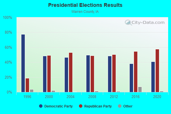
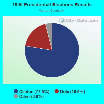
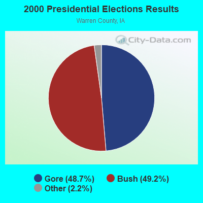
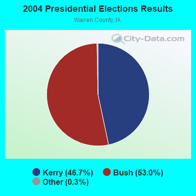
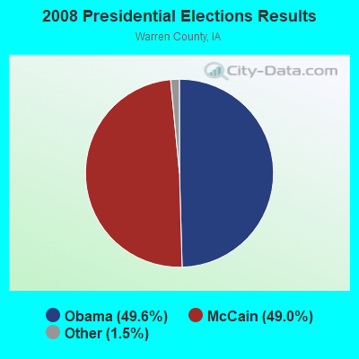

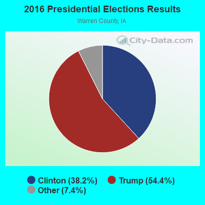
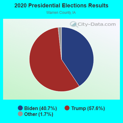
Graphs represent county-level data. Detailed 2008 Election Results
Religion statistics for Hartford, IA (based on Warren County data)
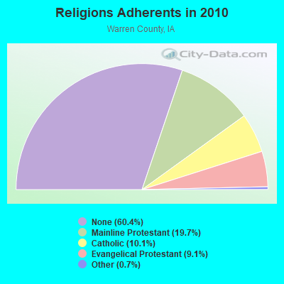
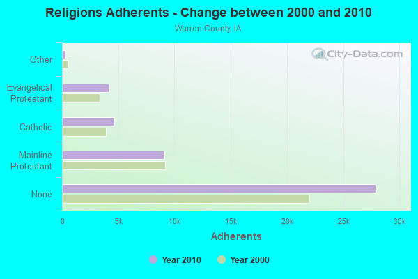
| Religion | Adherents | Congregations |
|---|---|---|
| Mainline Protestant | 9,123 | 29 |
| Catholic | 4,646 | 6 |
| Evangelical Protestant | 4,222 | 28 |
| Other | 331 | 3 |
| None | 27,903 | - |
Food Environment Statistics:
| Here: | 1.13 / 10,000 pop. |
| Iowa: | 2.14 / 10,000 pop. |
| Here: | 0.23 / 10,000 pop. |
| Iowa: | 0.23 / 10,000 pop. |
| Here: | 0.23 / 10,000 pop. |
| Iowa: | 0.43 / 10,000 pop. |
| This county: | 5.18 / 10,000 pop. |
| Iowa: | 5.55 / 10,000 pop. |
| Here: | 3.83 / 10,000 pop. |
| Iowa: | 8.01 / 10,000 pop. |
| This county: | 7.4% |
| Iowa: | 7.8% |
| Warren County: | 30.6% |
| Iowa: | 27.3% |
| Warren County: | 14.0% |
| Iowa: | 14.5% |
Health and Nutrition:
| Hartford: | 49.2% |
| State: | 49.5% |
| Hartford: | 50.7% |
| Iowa: | 46.1% |
| Here: | 29.4 |
| Iowa: | 28.6 |
| Hartford: | 20.7% |
| State: | 21.4% |
| Hartford: | 10.3% |
| Iowa: | 10.4% |
| Hartford: | 6.8 |
| Iowa: | 6.8 |
| Here: | 43.2% |
| Iowa: | 33.8% |
| Here: | 56.9% |
| Iowa: | 55.9% |
| Hartford: | 81.7% |
| State: | 77.7% |
More about Health and Nutrition of Hartford, IA Residents
| Local government employment and payroll (March 2022) | |||||
| Function | Full-time employees | Monthly full-time payroll | Average yearly full-time wage | Part-time employees | Monthly part-time payroll |
|---|---|---|---|---|---|
| Other Government Administration | 1 | $4,393 | $52,716 | 0 | $0 |
| Sewerage | 0 | $0 | 4 | $864 | |
| Other and Unallocable | 0 | $0 | 4 | $3,888 | |
| Solid Waste Management | 0 | $0 | 4 | $1,512 | |
| Totals for Government | 1 | $4,393 | $52,716 | 12 | $6,264 |
Hartford government finances - Expenditure in 2017 (per resident):
- Current Operations - Sewerage: $408,000 ($561.98)
Regular Highways: $127,000 ($174.93)
Local Fire Protection: $54,000 ($74.38)
Financial Administration: $50,000 ($68.87)
Solid Waste Management: $39,000 ($53.72)
General - Other: $36,000 ($49.59)
Judicial and Legal Services: $11,000 ($15.15)
General Public Buildings: $11,000 ($15.15)
Health - Other: $8,000 ($11.02)
Parks and Recreation: $5,000 ($6.89)
Police Protection: $5,000 ($6.89)
Central Staff Services: $4,000 ($5.51)
Libraries: $2,000 ($2.75)
Protective Inspection and Regulation - Other: $2,000 ($2.75)
- General - Interest on Debt: $25,000 ($34.44)
- Other Capital Outlay - Health - Other: $8,000 ($11.02)
Local Fire Protection: $7,000 ($9.64)
- Total Salaries and Wages: $94,000 ($129.48)
Hartford government finances - Revenue in 2017 (per resident):
- Charges - Sewerage: $179,000 ($246.56)
Solid Waste Management: $36,000 ($49.59)
Other: $10,000 ($13.77)
- Local Intergovernmental - Other: $53,000 ($73.00)
- Miscellaneous - Interest Earnings: $10,000 ($13.77)
Fines and Forfeits: $2,000 ($2.75)
- State Intergovernmental - Highways: $96,000 ($132.23)
- Tax - Property: $182,000 ($250.69)
General Sales and Gross Receipts: $98,000 ($134.99)
Public Utilities Sales: $29,000 ($39.94)
Other License: $2,000 ($2.75)
Hartford government finances - Debt in 2017 (per resident):
- Long Term Debt - Beginning Outstanding - Unspecified Public Purpose: $622,000 ($856.75)
Outstanding Unspecified Public Purpose: $582,000 ($801.65)
Retired Unspecified Public Purpose: $40,000 ($55.10)
- Short Term Debt Outstanding - Beginning: $27,000 ($37.19)
End of Fiscal Year: $19,000 ($26.17)
Hartford government finances - Cash and Securities in 2017 (per resident):
- Other Funds - Cash and Securities: $1,213,000 ($1670.80)
Strongest AM radio stations in Hartford:
- KPSZ (940 AM; 10 kW; DES MOINES, IA; Owner: SAGA COMMUNICATIONS OF IOWA, LLC)
- WHO (1040 AM; 50 kW; DES MOINES, IA; Owner: CITICASTERS LICENSES, L.P.)
- KBGG (1700 AM; 10 kW; DES MOINES, IA; Owner: CITADEL BROADCASTING COMPANY)
- KRNT (1350 AM; 5 kW; DES MOINES, IA; Owner: SAGA COMMUNICATIONS OF IOWA, LLC)
- KXNO (1460 AM; 5 kW; DES MOINES, IA; Owner: CAPSTAR TX LIMITED PARTNERSHIP)
- KXEL (1540 AM; 50 kW; WATERLOO, IA; Owner: KXEL BROADCASTING COMPANY, INC.)
- KXLQ (1490 AM; 1 kW; INDIANOLA, IA; Owner: WARREN BROADCASTING, INC.)
- WOI (640 AM; 5 kW; AMES, IA; Owner: IOWA STATE UNIV., OF SCIENCE & TECH.)
- KWKY (1150 AM; 1 kW; DES MOINES, IA; Owner: PUTBRESE COMMUNICATIONS, LTD.)
- KOIL (1020 AM; 50 kW; PLATTSMOUTH, NE; Owner: WAITT RADIO, INC.)
- KFAB (1110 AM; 50 kW; OMAHA, NE; Owner: CAPSTAR TX LIMITED PARTNERSHIP)
- WHB (810 AM; 50 kW; KANSAS CITY, MO; Owner: UNION BROADCASTING, INC.)
- KKAR (1290 AM; 50 kW; OMAHA, NE; Owner: WAITT RADIO, INC.)
Strongest FM radio stations in Hartford:
- KAZR (103.3 FM; PELLA, IA; Owner: SAGA COMMUNICATIONS OF IOWA, LLC)
- KIOA (93.3 FM; DES MOINES, IA; Owner: SAGA COMMUNICATIONS OF IOWA, LLC)
- KGGO (94.9 FM; DES MOINES, IA; Owner: CITADEL BROADCASTING COMPANY)
- KMXD (100.3 FM; DES MOINES, IA; Owner: CITICASTERS LICENSES, L.P.)
- KKDM (107.5 FM; DES MOINES, IA; Owner: CLEAR CHANNEL BROADCASTING LICENSES, INC.)
- WOI-FM (90.1 FM; AMES, IA; Owner: IOWA STATE UNIVERSITY OF SCI & TECH)
- KSTZ (102.5 FM; DES MOINES, IA; Owner: SAGA COMMUNICATIONS OF IOWA, LLC)
- KDFR (91.3 FM; DES MOINES, IA; Owner: FAMILY STATIONS, INC.)
- KJMC (89.3 FM; DES MOINES, IA; Owner: MINORITY COMMUNICATIONS, INC.)
- KJJY (92.5 FM; WEST DES MOINES, IA; Owner: CITADEL BROADCASTING COMPANY)
- K269EJ (101.7 FM; DES MOINES, IA; Owner: UNIVERSITY OF NORTHERN IOWA)
- KLTI-FM (104.1 FM; AMES, IA; Owner: SAGA COMMUNICATIONS OF IOWA, LLC)
- KVJZ (106.3 FM; ANKENY, IA; Owner: CITICASTERS LICENSES, L.P.)
- KHKI (97.3 FM; DES MOINES, IA; Owner: CITADEL BROADCASTING COMPANY)
- KRKQ (98.3 FM; BOONE, IA; Owner: CITADEL BROADCASTING COMPANY)
- KSTM (88.9 FM; INDIANOLA, IA; Owner: SIMPSON COLLEGE)
- KRLS (92.1 FM; KNOXVILLE, IA; Owner: M AND H BROADCASTING, INC.)
TV broadcast stations around Hartford:
- WOI-TV (Channel 5; AMES, IA; Owner: CAPITAL COMMUNICATIONS COMPANY, INC.)
- KDIN-TV (Channel 11; DES MOINES, IA; Owner: IOWA PUBLIC BROADCASTING BOARD)
- WBXF-CA (Channel 4; DES MOINES, IA; Owner: THE BOX WORLDWIDE LLC)
- KPWB-TV (Channel 23; AMES, IA; Owner: PAPPAS TELECASTING OF IOWA, L.L.C.)
- KDSM-TV (Channel 17; DES MOINES, IA; Owner: KDSM LICENSEE, LLC)
- KCCI (Channel 8; DES MOINES, IA; Owner: DES MOINES HEARST-ARGYLE TV, INC.)
- WHO-TV (Channel 13; DES MOINES, IA; Owner: NEW YORK TIMES MANAGEMENT SERVICES)
- KRPG-LP (Channel 43; DES MOINES, IA; Owner: TIGER EYE BROADCASTING CORPORATION)
- K41DD (Channel 41; DES MOINES, IA; Owner: VENTANA TELEVISION, INC.)
- KFPX (Channel 39; NEWTON, IA; Owner: PAXSON DES MOINES LICENSE, INC.)
- K29EA (Channel 29; DES MOINES, IA; Owner: TV-45, INC.)
- K46EY (Channel 46; DES MOINES, IA; Owner: TV-45, INC.)
Hartford fatal accident list:
Jan 27, 1986 01:00 PM, Hwy 5, Vehicles: 2, Persons: 3, Fatalities: 1
- National Bridge Inventory (NBI) Statistics
- 7Number of bridges
- 118ft / 35.9mTotal length
- 17,310Total average daily traffic
- 1,530Total average daily truck traffic
- 17,310Total future (year 2040) average daily traffic
FCC Registered Antenna Towers:
25 (See the full list of FCC Registered Antenna Towers in Hartford)FCC Registered Commercial Land Mobile Towers:
1- Lat: 41.476389 Lon: -93.374111, Structure height: 12 m, Call Sign: KPL756,
Assigned Frequencies: 455.980 MHz, Grant Date: 04/17/1989, Expiration Date: 02/01/2029, Registrant: Smithwick & Belendiuk, P.C., 5028 Wisconsin Avenue, Nw, Suite 301, Washington, DC 20016, Phone: (202) 363-4050, Fax: (202) 363-4266, Email:
FCC Registered Broadcast Land Mobile Towers:
1- MURPHY, 3722 215th Ave (Lat: 41.468778 Lon: -93.396167), Type: Ltower, Structure height: 91.4 m, Overall height: 94.5 m, Call Sign: WRMV604,
Assigned Frequencies: 154.370 MHz, Grant Date: 06/10/2021, Expiration Date: 06/10/2031, Certifier: Douglas Mccasland, Registrant: Motorola Solutions, 324 Kingsport Ct, Crystal Lake, IL 60012, Phone: (847) 875-2785, Email:
FCC Registered Microwave Towers:
3- A298 Hartford, Near Hartford (Lat: 41.463583 Lon: -93.411639), Type: Ltower, Structure height: 46 m, Overall height: 48.8 m, Call Sign: WQYA843,
Assigned Frequencies: 10935.0 MHz, 10935.0 MHz, 10935.0 MHz, 10935.0 MHz, 10935.0 MHz, 10935.0 MHz, 10935.0 MHz, Grant Date: 08/02/2016, Expiration Date: 08/02/2026, Cancellation Date: 02/25/2021, Certifier: David Werblow, Registrant: 12920 Se 38th Street, Bellevue, WA 98006, Phone: (425) 383-8401, Fax: (425) 383-4840, Email:
- MURPHY TOWER, 3722 215th Ave (Lat: 41.468778 Lon: -93.396167), Type: Ltower, Structure height: 91.4 m, Overall height: 94.5 m, Call Sign: WRLD458, Licensee ID: L00039669,
Assigned Frequencies: 6004.50 MHz, 6093.45 MHz, 6004.50 MHz, 6093.45 MHz, 6004.50 MHz, 6093.45 MHz, 6004.50 MHz, 6093.45 MHz, 6004.50 MHz, 6093.45 MHz, 6004.50 MHz, 6093.45 MHz, Grant Date: 03/11/2021, Expiration Date: 03/11/2031, Certifier: Doug Mccasland, Registrant: Warren County, Iowa, 115 N Howard St, Indianola, IA 50125, Phone: (515) 961-1093, Email:
- IAHARTFORDSE, 6563 S31 Hwy (Lat: 41.428000 Lon: -93.356861), Type: Ltower, Structure height: 36.6 m, Call Sign: WRNP252, Licensee ID: L01704672,
Assigned Frequencies: 11405.0 MHz, 11405.0 MHz, 11405.0 MHz, 11405.0 MHz, 11405.0 MHz, 11405.0 MHz, 11405.0 MHz, 11405.0 MHz, 11405.0 MHz, 11405.0 MHz, Grant Date: 08/03/2021, Expiration Date: 08/03/2031, Cancellation Date: 03/02/2022, Certifier: Jack Marsh, Registrant: Amg Technology Investment Group, 95 Parker Oaks Lane, Hudson Oaks, TX 76087, Phone: (855) 698-5465, Email:
FCC Registered Amateur Radio Licenses:
6- Call Sign: KB0DCW, Grant Date: 08/09/1988, Expiration Date: 08/09/1998, Cancellation Date: 08/10/2000, Registrant: Tracy K Carpenter, Hartford, IA 50118
- Call Sign: KB0DCX, Grant Date: 08/09/1988, Expiration Date: 08/09/1998, Cancellation Date: 08/10/2000, Registrant: Michael D Carpenter, Hartford, IA 50118
- Call Sign: KB0DDJ, Grant Date: 08/16/1988, Expiration Date: 08/16/1998, Cancellation Date: 08/17/2000, Registrant: Michelle A Carpenter, Hartford, IA 50118
- Call Sign: KB0DDK, Grant Date: 08/16/1988, Expiration Date: 08/16/1998, Cancellation Date: 08/17/2000, Registrant: David K Carpenter, Hartford, IA 50118
- Call Sign: KB0YDB, Licensee ID: L01147851, Grant Date: 05/25/2016, Expiration Date: 07/30/2026, Certifier: Harvey E Blanchard, Registrant: Harvey E Blanchard, 200 N Vine St, Hartford, IA 50118
- Call Sign: KE0LGB, Licensee ID: L02067242, Grant Date: 12/01/2016, Expiration Date: 12/01/2026, Certifier: William E Jors, Registrant: William E Jors, 245 George Street, Hartford, IA 50118
FAA Registered Aircraft:
3- Aircraft: TAYLORCRAFT BL (Category: Land, Seats: 2, Weight: Up to 12,499 Pounds, Speed: 78 mph), Engine: Reciprocating
N-Number: 26658, N26658, N-26658, Serial Number: 2000, Year manufactured: 1940, Airworthiness Date: 07/28/1977, Certificate Issue Date: 10/04/2017
Registrant (Individual): Chad E Follis, Po Box 44, Hartford, IA 50118 - Aircraft: RICK MARBLE RV-9 (Category: Land, Seats: 2, Weight: Up to 12,499 Pounds), Engine: LYCOMING IO-320-D1A (160 HP) (4 Cycle)
N-Number: 279K, N279K, N-279K, Serial Number: 90859, Year manufactured: 2014, Airworthiness Date: 02/18/2014, Certificate Issue Date: 01/10/2014
Registrant (Individual): Rick W Marble, Po Box 211, Hartford, IA 50118 - Aircraft: BEECH V35A (Category: Land, Seats: 6, Weight: Up to 12,499 Pounds, Speed: 150 mph), Engine: CONT MOTOR IO 520 SERIES (285 HP) (Reciprocating)
N-Number: 6296V, N6296V, N-6296V, Serial Number: D-8621, Year manufactured: 1967, Airworthiness Date: 11/13/1967, Certificate Issue Date: 08/14/2017
Registrant (Co-Owned): Chad Follis, 210 S Washington St, Hartford, IA 50118, Other Owners: Angie Follis
| Home Mortgage Disclosure Act Aggregated Statistics For Year 2009 (Based on 1 partial tract) | ||
| C) Refinancings | ||
|---|---|---|
| Number | Average Value | |
| LOANS ORIGINATED | 1 | $121,250 |
| APPLICATIONS APPROVED, NOT ACCEPTED | 0 | $0 |
| APPLICATIONS DENIED | 0 | $0 |
| APPLICATIONS WITHDRAWN | 0 | $0 |
| FILES CLOSED FOR INCOMPLETENESS | 0 | $0 |
Detailed HMDA statistics for the following Tracts: 0205.00
| Most common first names in Hartford, IA among deceased individuals | ||
| Name | Count | Lived (average) |
|---|---|---|
| Mildred | 4 | 79.0 years |
| Earl | 3 | 76.3 years |
| Edward | 3 | 74.4 years |
| James | 3 | 63.3 years |
| George | 3 | 69.3 years |
| Kenneth | 3 | 76.3 years |
| Robert | 3 | 75.0 years |
| William | 2 | 69.0 years |
| Irene | 2 | 80.5 years |
| Edna | 2 | 82.6 years |
| Most common last names in Hartford, IA among deceased individuals | ||
| Last name | Count | Lived (average) |
|---|---|---|
| Shetterly | 5 | 83.6 years |
| Hammond | 4 | 73.2 years |
| Bengtson | 4 | 26.7 years |
| Smith | 4 | 84.0 years |
| Isley | 3 | 71.0 years |
| Darr | 3 | 77.3 years |
| Mccaughey | 3 | 74.3 years |
| Miller | 3 | 79.0 years |
| Pendry | 3 | 84.4 years |
| Hunt | 2 | 86.5 years |

- 72.7%Utility gas
- 22.9%Electricity
- 3.7%Wood
- 0.8%Bottled, tank, or LP gas

- 91.7%Utility gas
- 8.3%Electricity
Hartford compared to Iowa state average:
- Unemployed percentage significantly below state average.
- Black race population percentage significantly below state average.
- Hispanic race population percentage below state average.
- Median age significantly below state average.
- Foreign-born population percentage significantly below state average.
- Renting percentage significantly below state average.
- Length of stay since moving in significantly above state average.
- Number of college students significantly below state average.
- Percentage of population with a bachelor's degree or higher below state average.