Henrietta, Missouri
Submit your own pictures of this city and show them to the world
- OSM Map
- General Map
- Google Map
- MSN Map
Population change since 2000: -40.0%
 |
| Males: 160 | |
| Females: 114 |
| Median resident age: | 32.0 years |
| Missouri median age: | 39.1 years |
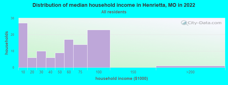
| Henrietta: | $43,014 |
| MO: | $64,811 |
Estimated per capita income in 2022: $18,355 (it was $16,129 in 2000)
Henrietta city income, earnings, and wages data
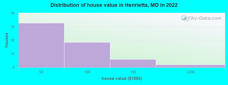
Estimated median house or condo value in 2022: $-739,551,989 (it was $48,800 in 2000)
| Henrietta: | |
| MO: |
Mean prices in 2022: all housing units: $51,793; detached houses: $69,949; mobile homes: $9,667
Median gross rent in 2022: $725.
(30.7% for White Non-Hispanic residents, 33.3% for two or more races residents)
Detailed information about poverty and poor residents in Henrietta, MO
Compare current foreclosures near Henrietta, MO:
| Photo | Address | Area | Beds / Baths | Price | Details |
|---|---|---|---|---|---|

|
#1
4th St
Henrietta, MO 64036
|
974 sq. feet
|
1 baths 2 beds |
show details | |

|
#2
Vaughn St
Excelsior Springs, MO 64024
|
900 sq. feet
|
1 baths 2 beds |
$5,900
|
show details |

|
#3
Klatt Rd
Excelsior Springs, MO 64024
|
1,008 sq. feet
|
1 baths 3 beds |
show details | |

|
#4
E Elm St
Orrick, MO 64077
|
560 sq. feet
|
1 baths 2 beds |
show details | |

|
#5
E Elm St
Hardin, MO 64035
|
1,720 sq. feet
|
1 baths 3 beds |
show details | |

|
#6
Monroe St
Lexington, MO 64067
|
1,346 sq. feet
|
1 baths 2 beds |
show details | |

|
#7
S Osage St
Buckner, MO 64016
|
975 sq. feet
|
1 baths 2 beds |
show details | |

|
#8
Cliff Dr
Buckner, MO 64016
|
1,275 sq. feet
|
2 baths 3 beds |
show details | |

|
#9
Barley Ln
Buckner, MO 64016
|
1,014 sq. feet
|
1 baths 3 beds |
show details | |

|
#10
Barley Ln
Buckner, MO 64016
|
1,014 sq. feet
|
1 baths 3 beds |
show details |
| Photo | Address | Area | Beds / Baths | Price | Details |
|---|---|---|---|---|---|

|
#11
Ash St
Excelsior Springs, MO 64024
|
708 sq. feet
|
1 baths 2 beds |
show details | |

|
#12
Isley Blvd
Excelsior Springs, MO 64024
|
1,090 sq. feet
|
1 baths 2 beds |
show details | |

|
#13
W Main St
Odessa, MO 64076
|
1,458 sq. feet
|
- baths 2 beds |
show details | |

|
#14
Clevenger Rd
Excelsior Springs, MO 64024
|
1,215 sq. feet
|
- baths 3 beds |
show details | |

|
#15
Greenton Trl
Odessa, MO 64076
|
1,626 sq. feet
|
- baths 3 beds |
show details | |

|
#16
W South St
Richmond, MO 64085
|
864 sq. feet
|
- baths 2 beds |
show details | |

|
#17
Rose Ln
Excelsior Springs, MO 64024
|
924 sq. feet
|
- baths 3 beds |
show details | |

|
#18
W 160th St
Rayville, MO 64084
|
1,666 sq. feet
|
- baths 3 beds |
show details | |

|
#19
Kent Dr
Excelsior Springs, MO 64024
|
816 sq. feet
|
- baths 2 beds |
show details | |

|
#20
W 160th St
Rayville, MO 64084
|
1,288 sq. feet
|
- baths 3 beds |
show details |
| Photo | Address | Area | Beds / Baths | Price | Details |
|---|---|---|---|---|---|

|
#21
Fire Branch Rd
Rayville, MO 64084
|
1,040 sq. feet
|
- baths 3 beds |
show details | |

|
#22
W 21st St
Higginsville, MO 64037
|
988 sq. feet
|
- baths 4 beds |
show details | |

|
#23
Arapahoe Dr
Excelsior Springs, MO 64024
|
1,436 sq. feet
|
- baths 3 beds |
show details | |

|
#24
Crowley Rd
Rayville, MO 64084
|
1,190 sq. feet
|
- baths 3 beds |
show details | |

|
#25
E Orchard St
Odessa, MO 64076
|
1,125 sq. feet
|
- baths 3 beds |
show details | |

|
#26
W Broadway St
Higginsville, MO 64037
|
1,377 sq. feet
|
- baths 8 beds |
show details | |

|
#27
S Wellington St
Richmond, MO 64085
|
768 sq. feet
|
- baths 2 beds |
show details | |

|
#28
W 118th St
Excelsior Springs, MO 64024
|
1,500 sq. feet
|
- baths 3 beds |
show details | |

|
#29
Pleasant Prairie Rd
Napoleon, MO 64074
|
1,574 sq. feet
|
- baths 3 beds |
show details | |

|
#30
W 73rd St
Orrick, MO 64077
|
964 sq. feet
|
- baths 2 beds |
show details |
| Photo | Address | Area | Beds / Baths | Price | Details |
|---|---|---|---|---|---|

|
#31
SE 3rd St
Hardin, MO 64035
|
984 sq. feet
|
- baths 2 beds |
show details | |

|
#32
Dockery Rd
Richmond, MO 64085
|
1,128 sq. feet
|
- baths 2 beds |
show details | |

|
#33
Biddle St
Camden, MO 64017
|
1,080 sq. feet
|
- baths 3 beds |
show details | |

|
#34
Oneida St
Lexington, MO 64067
|
960 sq. feet
|
- baths 2 beds |
show details | |

|
#35
Old Canyon Rd
Wellington, MO 64097
|
1,606 sq. feet
|
- baths 3 beds |
show details | |

|
#36
Main St
Lexington, MO 64067
|
1,512 sq. feet
|
- baths 4 beds |
show details | |

|
#37
N 16th St
Lexington, MO 64067
|
1,000 sq. feet
|
- baths 3 beds |
show details | |

|
#38
Marion Ln
Lexington, MO 64067
|
1,264 sq. feet
|
- baths 2 beds |
show details | |

|
#39
Highway M
Rayville, MO 64084
|
1,130 sq. feet
|
- baths 3 beds |
show details | |

|
#40
N College St
Richmond, MO 64085
|
1,543 sq. feet
|
- baths 3 beds |
show details |
| Photo | Address | Area | Beds / Baths | Price | Details |
|---|---|---|---|---|---|

|
#41
W Elm St
Orrick, MO 64077
|
2,064 sq. feet
|
- baths 4 beds |
show details | |

|
#42
W 156th St
Rayville, MO 64084
|
2,010 sq. feet
|
- baths 4 beds |
show details | |

|
#43
Tunis St
Camden, MO 64017
|
1,152 sq. feet
|
- baths 3 beds |
show details | |

|
#44
Cherokee Dr
Excelsior Springs, MO 64024
|
1,216 sq. feet
|
- baths - beds |
show details | |

|
#45
Oak Ave Apt 3
Richmond, MO 64085
|
- sq. feet
|
- baths - beds |
show details | |

|
#46
Country Club Ter
Lexington, MO 64067
|
- sq. feet
|
- baths - beds |
show details | |

|
#47
Wood Oak Ave Apt 1
Richmond, MO 64085
|
- sq. feet
|
- baths - beds |
show details | |

|
#48
S Riner Rd
Buckner, MO 64016
|
- sq. feet
|
- baths - beds |
show details | |

|
#49
Tarsney Ln
Buckner, MO 64016
|
- sq. feet
|
- baths - beds |
show details | |

|
Check over 1 million property listings on Foreclosure.com!
|
browse all offers | |||


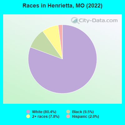
- 23880.4%White alone
- 289.5%Black alone
- 237.8%Two or more races
- 62.0%Hispanic
Races in Henrietta detailed stats: ancestries, foreign born residents, place of birth
According to our research of Missouri and other state lists, there were 4 registered sex offenders living in Henrietta, Missouri as of May 17, 2024.
The ratio of all residents to sex offenders in Henrietta is 87 to 1.
Type |
2009 |
2010 |
2011 |
2012 |
2013 |
2014 |
2015 |
2016 |
2017 |
2018 |
|---|---|---|---|---|---|---|---|---|---|---|
| Murders (per 100,000) | 0 (0.0) | 0 (0.0) | 0 (0.0) | 0 (0.0) | 0 (0.0) | 0 (0.0) | 0 (0.0) | 0 (0.0) | 0 (0.0) | 0 (0.0) |
| Rapes (per 100,000) | 0 (0.0) | 0 (0.0) | 0 (0.0) | 0 (0.0) | 0 (0.0) | 0 (0.0) | 2 (552.5) | 0 (0.0) | 0 (0.0) | 1 (281.7) |
| Robberies (per 100,000) | 0 (0.0) | 0 (0.0) | 0 (0.0) | 0 (0.0) | 0 (0.0) | 0 (0.0) | 0 (0.0) | 0 (0.0) | 0 (0.0) | 0 (0.0) |
| Assaults (per 100,000) | 0 (0.0) | 0 (0.0) | 1 (270.3) | 2 (545.0) | 3 (826.4) | 1 (280.1) | 1 (276.2) | 0 (0.0) | 0 (0.0) | 0 (0.0) |
| Burglaries (per 100,000) | 0 (0.0) | 0 (0.0) | 0 (0.0) | 2 (545.0) | 0 (0.0) | 1 (280.1) | 0 (0.0) | 2 (555.6) | 3 (835.7) | 0 (0.0) |
| Thefts (per 100,000) | 2 (466.2) | 1 (271.0) | 1 (270.3) | 3 (817.4) | 1 (275.5) | 1 (280.1) | 0 (0.0) | 6 (1,667) | 3 (835.7) | 2 (563.4) |
| Auto thefts (per 100,000) | 0 (0.0) | 0 (0.0) | 0 (0.0) | 0 (0.0) | 0 (0.0) | 0 (0.0) | 2 (552.5) | 0 (0.0) | 0 (0.0) | 0 (0.0) |
| Arson (per 100,000) | 0 (0.0) | 0 (0.0) | 0 (0.0) | 0 (0.0) | 0 (0.0) | 0 (0.0) | 0 (0.0) | 0 (0.0) | 0 (0.0) | 0 (0.0) |
| City-Data.com crime index | 18.6 | 10.8 | 64.9 | 179.8 | 176.3 | 86.8 | 541.4 | 105.6 | 91.9 | 247.9 |
The City-Data.com crime index weighs serious crimes and violent crimes more heavily. Higher means more crime, U.S. average is 246.1. It adjusts for the number of visitors and daily workers commuting into cities.
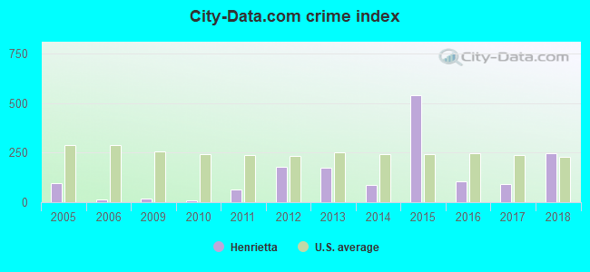
Crime rate in Henrietta detailed stats: murders, rapes, robberies, assaults, burglaries, thefts, arson
Full-time law enforcement employees in 2019, including police officers: 1 (1 officers - 1 male; 0 female).
| Officers per 1,000 residents here: | 2.82 |
| Missouri average: | 2.48 |
 Recent articles from our blog. Our writers, many of them Ph.D. graduates or candidates, create easy-to-read articles on a wide variety of topics.

 | Long ago on independence square (13162 replies) |
| Missouri Outlaw History (3407 replies) |
Latest news from Henrietta, MO collected exclusively by city-data.com from local newspapers, TV, and radio stations
Ancestries: American (35.8%), Irish (14.6%), German (10.6%), Scotch-Irish (4.1%), African (4.1%), Swedish (1.6%).
Current Local Time: CST time zone
Incorporated in 1874
Land area: 0.60 square miles.
Population density: 459 people per square mile (low).
26 residents are foreign born (5.7% Latin America).
| This city: | 5.7% |
| Missouri: | 2.7% |
Median real estate property taxes paid for housing units with mortgages in 2022: $680 (0.7%)
Median real estate property taxes paid for housing units with no mortgage in 2022: $413 (3.7%)
Nearest city with pop. 50,000+: Independence, MO  (27.5 miles , pop. 113,288).
Nearest city with pop. 200,000+: Kansas City, MO (35.0 miles , pop. 441,545).
Nearest city with pop. 1,000,000+: Chicago, IL (374.8 miles , pop. 2,896,016).
Nearest cities:
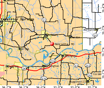
), ), Latitude: 39.24 N, Longitude: 93.94 W
Area code: 816

| Here: | 2.8% |
| Missouri: | 2.8% |
- Accommodation & food services (9.5%)
- Transportation equipment (7.1%)
- Construction (7.1%)
- Health care (5.6%)
- Food (4.8%)
- Administrative & support & waste management services (4.8%)
- Professional, scientific, technical services (4.8%)
- Construction (11.3%)
- Transportation equipment (9.9%)
- Miscellaneous manufacturing (7.0%)
- Accommodation & food services (7.0%)
- Food (5.6%)
- Publishing, motion picture & sound recording industries (5.6%)
- Broadcasting & telecommunications (5.6%)
- Accommodation & food services (12.7%)
- Department & other general merchandise stores (9.1%)
- Food & beverage stores (9.1%)
- Health care (9.1%)
- Administrative & support & waste management services (7.3%)
- Metal & metal products (5.5%)
- Professional, scientific, technical services (5.5%)
- Laborers and material movers, hand (11.1%)
- Assemblers and fabricators (7.1%)
- Cashiers (5.6%)
- Other office and administrative support workers, including supervisors (5.6%)
- Carpenters (5.6%)
- Electrical equipment mechanics and other installation, maintenance, and repair workers, including supervisors (5.6%)
- Media and communications workers (4.0%)
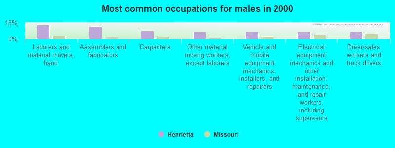
- Laborers and material movers, hand (14.1%)
- Assemblers and fabricators (12.7%)
- Carpenters (8.5%)
- Other material moving workers, except laborers (7.0%)
- Vehicle and mobile equipment mechanics, installers, and repairers (7.0%)
- Electrical equipment mechanics and other installation, maintenance, and repair workers, including supervisors (7.0%)
- Driver/sales workers and truck drivers (7.0%)
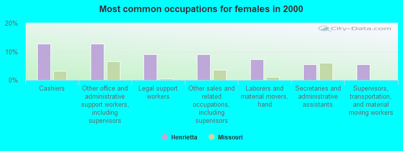
- Cashiers (12.7%)
- Other office and administrative support workers, including supervisors (12.7%)
- Legal support workers (9.1%)
- Other sales and related occupations, including supervisors (9.1%)
- Laborers and material movers, hand (7.3%)
- Secretaries and administrative assistants (5.5%)
- Supervisors, transportation, and material moving workers (5.5%)
Average climate in Henrietta, Missouri
Based on data reported by over 4,000 weather stations


(lower is better)
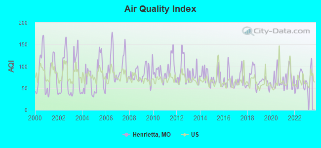
Air Quality Index (AQI) level in 2022 was 65.3. This is about average.
| City: | 65.3 |
| U.S.: | 72.6 |
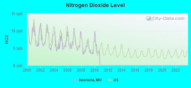
Nitrogen Dioxide (NO2) [ppb] level in 2010 was 5.32. This is about average. Closest monitor was 24.1 miles away from the city center.
| City: | 5.32 |
| U.S.: | 5.11 |
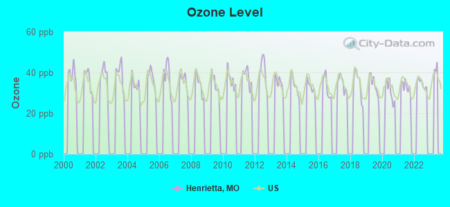
Ozone [ppb] level in 2022 was 34.6. This is about average. Closest monitor was 21.2 miles away from the city center.
| City: | 34.6 |
| U.S.: | 33.3 |
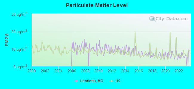
Particulate Matter (PM2.5) [µg/m3] level in 2022 was 5.66. This is significantly better than average. Closest monitor was 24.1 miles away from the city center.
| City: | 5.66 |
| U.S.: | 8.11 |
Tornado activity:
Henrietta-area historical tornado activity is near Missouri state average. It is 71% greater than the overall U.S. average.
On 5/4/1977, a category F4 (max. wind speeds 207-260 mph) tornado 6.7 miles away from the Henrietta city center injured one person and caused between $500,000 and $5,000,000 in damages.
On 5/20/1957, a category F5 (max. wind speeds 261-318 mph) tornado 30.6 miles away from the city center killed 44 people and injured 207 people and caused between $500,000 and $5,000,000 in damages.
Earthquake activity:
Henrietta-area historical earthquake activity is significantly above Missouri state average. It is 451% greater than the overall U.S. average.On 9/3/2016 at 12:02:44, a magnitude 5.8 (5.8 MW, Depth: 3.5 mi, Class: Moderate, Intensity: VI - VII) earthquake occurred 254.0 miles away from the city center
On 11/6/2011 at 03:53:10, a magnitude 5.7 (5.7 MW, Depth: 3.2 mi) earthquake occurred 299.7 miles away from Henrietta center
On 4/18/2008 at 09:36:59, a magnitude 5.4 (5.1 MB, 4.8 MS, 5.4 MW, 5.2 MW) earthquake occurred 330.3 miles away from the city center
On 11/12/2014 at 21:40:00, a magnitude 4.9 (4.9 MW, Depth: 2.5 mi, Class: Light, Intensity: IV - V) earthquake occurred 241.9 miles away from the city center
On 11/7/2016 at 01:44:24, a magnitude 5.0 (5.0 MW, Depth: 2.8 mi) earthquake occurred 273.9 miles away from Henrietta center
On 9/26/1990 at 13:18:51, a magnitude 5.0 (4.7 MB, 4.8 LG, 5.0 LG, Depth: 7.7 mi) earthquake occurred 278.7 miles away from Henrietta center
Magnitude types: regional Lg-wave magnitude (LG), body-wave magnitude (MB), surface-wave magnitude (MS), moment magnitude (MW)
Natural disasters:
The number of natural disasters in Ray County (31) is a lot greater than the US average (15).Major Disasters (Presidential) Declared: 22
Emergencies Declared: 6
Causes of natural disasters: Floods: 22, Storms: 19, Tornadoes: 12, Winter Storms: 4, Winds: 2, Drought: 1, Heavy Rain: 1, Hurricane: 1, Ice Storm: 1, Snowstorm: 1, Other: 1 (Note: some incidents may be assigned to more than one category).

Hospitals and medical centers near Henrietta:
- FMC -LETHOLT DIALYSIS CENTER (Dialysis Facility, about 3 miles away; RICHMOND, MO)
- RAY COUNTY MEMORIAL HOSPITAL Critical Access Hospitals (about 3 miles away; RICHMOND, MO)
- SHIRKEY NURSING AND REHABILITATION CENTER (Nursing Home, about 3 miles away; RICHMOND, MO)
- LAFAYETTE REGIONAL HEALTH CENTER Critical Access Hospitals (about 5 miles away; LEXINGTON, MO)
- MEYER CARE CENTER (Nursing Home, about 16 miles away; HIGGINSVILLE, MO)
Colleges/universities with over 2000 students nearest to Henrietta:
- University of Central Missouri (about 35 miles; Warrensburg, MO; Full-time enrollment: 9,952)
- Rockhurst University (about 37 miles; Kansas City, MO; FT enrollment: 2,013)
- Metropolitan Community College-Kansas City (about 38 miles; Kansas City, MO; FT enrollment: 12,834)
- University of Missouri-Kansas City (about 38 miles; Kansas City, MO; FT enrollment: 10,544)
- Grantham University (about 40 miles; Kansas City, MO; FT enrollment: 8,385)
- Park University (about 40 miles; Parkville, MO; FT enrollment: 9,131)
- Kansas City Kansas Community College (about 45 miles; Kansas City, KS; FT enrollment: 4,718)
Points of interest:
| This city: | 2.6 people |
| Missouri: | 2.5 people |
| This city: | 68.8% |
| Whole state: | 65.3% |
| This city: | 9.2% |
| Whole state: | 6.7% |
No gay or lesbian households reported
123 people in local jails and other confinement facilities (including police lockups) in 2000
For population 15 years and over in Henrietta:
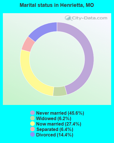
- Never married: 45.6%
- Now married: 27.4%
- Separated: 6.4%
- Widowed: 6.2%
- Divorced: 14.4%
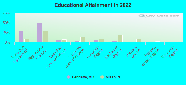
For population 25 years and over in Henrietta:
- High school or higher: 69.5%
- Bachelor's degree or higher: 3.9%
- Graduate or professional degree: 1.0%
- Unemployed: 3.1%
- Mean travel time to work (commute): 32.4 minutes
| Here: | 7.2 |
| Missouri average: | 11.1 |
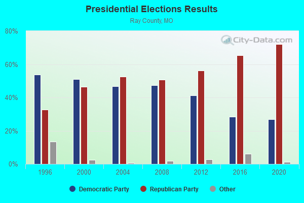
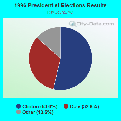
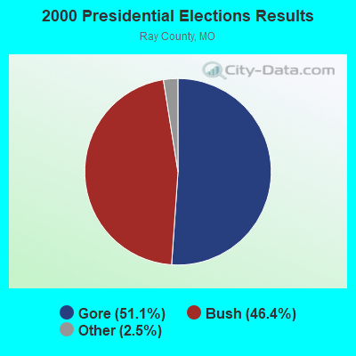
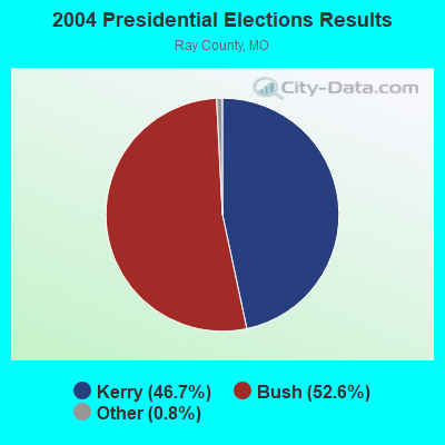
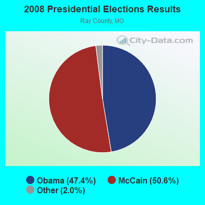
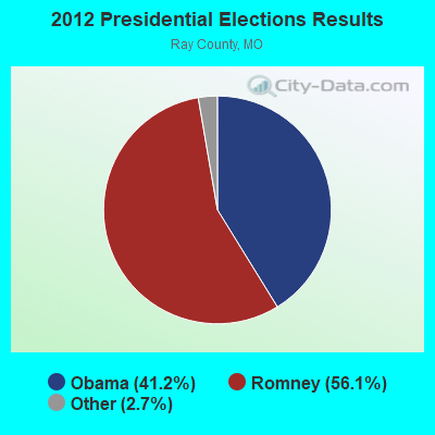
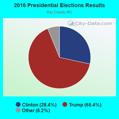
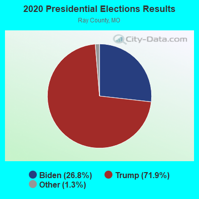
Graphs represent county-level data. Detailed 2008 Election Results
Religion statistics for Henrietta, MO (based on Ray County data)
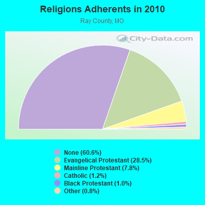
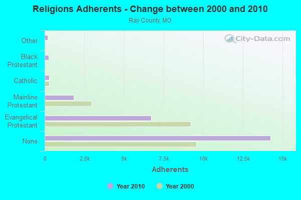
| Religion | Adherents | Congregations |
|---|---|---|
| Evangelical Protestant | 6,690 | 35 |
| Mainline Protestant | 1,839 | 13 |
| Catholic | 291 | 1 |
| Black Protestant | 246 | 2 |
| Other | 181 | 2 |
| None | 14,247 | - |
Food Environment Statistics:
| This county: | 1.28 / 10,000 pop. |
| Missouri: | 1.88 / 10,000 pop. |
| This county: | 0.43 / 10,000 pop. |
| Missouri: | 0.18 / 10,000 pop. |
| Here: | 5.97 / 10,000 pop. |
| State: | 4.34 / 10,000 pop. |
| Here: | 4.69 / 10,000 pop. |
| Missouri: | 7.37 / 10,000 pop. |
| Here: | 10.2% |
| Missouri: | 8.8% |
| This county: | 30.3% |
| Missouri: | 29.6% |
| This county: | 7.4% |
| Missouri: | 13.5% |
Health and Nutrition:
| This city: | 48.5% |
| Missouri: | 50.9% |
| Henrietta: | 46.3% |
| State: | 48.6% |
| This city: | 29.3 |
| Missouri: | 28.7 |
| Henrietta: | 22.4% |
| State: | 20.6% |
| Here: | 12.4% |
| State: | 10.1% |
| Henrietta: | 6.8 |
| Missouri: | 6.8 |
| This city: | 35.3% |
| Missouri: | 34.3% |
| Henrietta: | 57.2% |
| Missouri: | 57.5% |
| Here: | 79.1% |
| State: | 79.3% |
More about Health and Nutrition of Henrietta, MO Residents
| Local government employment and payroll (March 2022) | |||||
| Function | Full-time employees | Monthly full-time payroll | Average yearly full-time wage | Part-time employees | Monthly part-time payroll |
|---|---|---|---|---|---|
| Other Government Administration | 0 | $0 | 1 | $80 | |
| Financial Administration | 0 | $0 | 1 | $586 | |
| Judicial and Legal | 0 | $0 | 1 | $946 | |
| Other and Unallocable | 0 | $0 | 1 | $448 | |
| Police Protection - Officers | 0 | $0 | 2 | $1,516 | |
| Totals for Government | 0 | $0 | 6 | $3,576 | |
Henrietta government finances - Expenditure in 2017 (per resident):
- Construction - Parks and Recreation: $66,000 ($240.88)
Toll Highways: $6,000 ($21.90)
- Current Operations - Police Protection: $135,000 ($492.70)
Water Utilities: $94,000 ($343.07)
Sewerage: $80,000 ($291.97)
General Public Buildings: $72,000 ($262.77)
Parks and Recreation: $51,000 ($186.13)
General - Other: $30,000 ($109.49)
Toll Highways: $20,000 ($72.99)
- Total Salaries and Wages: $236,000 ($861.31)
- Water Utilities - Interest on Debt: $22,000 ($80.29)
Henrietta government finances - Revenue in 2017 (per resident):
- Charges - Sewerage: $79,000 ($288.32)
Solid Waste Management: $16,000 ($58.39)
- Miscellaneous - Fines and Forfeits: $73,000 ($266.42)
General Revenue - Other: $24,000 ($87.59)
Interest Earnings: $4,000 ($14.60)
Rents: $3,000 ($10.95)
- Revenue - Water Utilities: $89,000 ($324.82)
- State Intergovernmental - Highways: $14,000 ($51.09)
- Tax - General Sales and Gross Receipts: $372,000 ($1357.66)
Public Utilities Sales: $19,000 ($69.34)
Property: $16,000 ($58.39)
Occupation and Business License - Other: $1,000 ($3.65)
Henrietta government finances - Debt in 2017 (per resident):
- Long Term Debt - Beginning Outstanding - Unspecified Public Purpose: $551,000 ($2010.95)
Outstanding Unspecified Public Purpose: $551,000 ($2010.95)
Henrietta government finances - Cash and Securities in 2017 (per resident):
- Other Funds - Cash and Securities: $825,000 ($3010.95)
Strongest AM radio stations in Henrietta:
- WHB (810 AM; 50 kW; KANSAS CITY, MO; Owner: UNION BROADCASTING, INC.)
- KKHK (1250 AM; 25 kW; KANSAS CITY, KS)
- KCMO (710 AM; 10 kW; KANSAS CITY, MO; Owner: SUSQUEHANNA KANSAS CITY PARTNERSHIP)
- KCTE (1510 AM; daytime; 10 kW; INDEPENDENCE, MO; Owner: UNION BROADCASTING, INC.)
- KCCV (760 AM; daytime; 6 kW; OVERLAND PARK, KS; Owner: BOTT BROADCASTING COMPANY)
- KCSP (610 AM; 5 kW; KANSAS CITY, MO; Owner: ENTERCOM KANSAS CITY LICENSE, LLC)
- KXTR (1660 AM; 10 kW; KANSAS CITY, KS; Owner: ENTERCOM KANSAS CITY LICENSE, LLC)
- KLEX (1570 AM; 0 kW; LEXINGTON, MO; Owner: BOTT COMMUNICATIONS, INC.)
- KPHN (1190 AM; 5 kW; KANSAS CITY, MO; Owner: ABC, INC.)
- KMBZ (980 AM; 5 kW; KANSAS CITY, MO; Owner: ENTERCOM KANSAS CITY LICENSE, LLC)
- KEXS (1090 AM; daytime; 1 kW; EXCELSIOR SPRINGS, MO; Owner: JEFFCO TELEVISION CORP.)
- KCWJ (1030 AM; 1 kW; BLUE SPRINGS, MO; Owner: CHRISTIAN BROADCASTING ASSOCIATES, LP)
- KOIL (1020 AM; 50 kW; PLATTSMOUTH, NE; Owner: WAITT RADIO, INC.)
Strongest FM radio stations in Henrietta:
- KAYX (92.5 FM; RICHMOND, MO; Owner: BOTT COMMUNICATIONS, INC.)
- KMJK (107.3 FM; LEXINGTON, MO; Owner: ALLUR-KANSAS CITY, INC.)
- KSRC (102.1 FM; KANSAS CITY, MO; Owner: INFINITY RADIO OPERATIONS INC.)
- WDAF-FM (106.5 FM; LIBERTY, MO; Owner: ENTERCOM KANSAS CITY LICENSE, LLC)
- KUDL (98.1 FM; KANSAS CITY, KS; Owner: ENTERCOM KANSAS CITY LICENSE, LLC)
- KMZU (100.7 FM; CARROLLTON, MO; Owner: KANZA, INC.)
- KBEQ-FM (104.3 FM; KANSAS CITY, MO; Owner: INFINITY RADIO SUBSIDIARY OPERATIONS INC.)
- KQRC-FM (98.9 FM; LEAVENWORTH, KS; Owner: ENTERCOM KANSAS CITY LICENSE, LLC)
- KRBZ (96.5 FM; KANSAS CITY, MO; Owner: ENTERCOM KANSAS CITY LICENSE, LLC)
- KYYS (99.7 FM; KANSAS CITY, MO; Owner: ENTERCOM KANSAS CITY LICENSE, LLC)
- KMXV (93.3 FM; KANSAS CITY, MO; Owner: INFINITY RADIO OPERATIONS INC.)
- KRLI (103.9 FM; MALTA BEND, MO; Owner: KANZA, INC.)
- KZPL (97.3 FM; LEE'S SUMMIT, MO; Owner: UNION FIRST BROADCASTING, LLC)
- KCMO-FM (94.9 FM; KANSAS CITY, MO; Owner: SUSQUEHANNA KANSAS CITY PARTNERSHIP)
- KPRS (103.3 FM; KANSAS CITY, MO; Owner: CARTER BROADCAST GROUP, INC.)
- KCUR-FM (89.3 FM; KANSAS CITY, MO; Owner: CURATORS OF UNIVERSITY OF MISSOURI)
- KPOW-FM (97.7 FM; LA MONTE, MO; Owner: SEDALIA INVESTMENT GROUP LLC)
- KLJC (88.5 FM; KANSAS CITY, MO; Owner: CALVARY BIBLE COLLEGE)
- KMMO-FM (102.9 FM; MARSHALL, MO; Owner: MISSOURI VALLEY BROADCASTING, INC.)
- KCFX (101.1 FM; HARRISONVILLE, MO; Owner: SUSQUEHANNA KANSAS CITY PARTNERSHIP)
TV broadcast stations around Henrietta:
- KMBC-TV (Channel 9; KANSAS CITY, MO; Owner: KMBC HEARST-ARGYLE TELEVISION, INC.)
- KCPT (Channel 19; KANSAS CITY, MO; Owner: PUBLIC TELEVISION 19, INC.)
- KSMO-TV (Channel 62; KANSAS CITY, MO; Owner: KSMO LICENSEE, INC.)
- KCTV (Channel 5; KANSAS CITY, MO; Owner: MEREDITH CORPORATION)
- KCWE (Channel 29; KANSAS CITY, MO; Owner: KCWE-TV, INC.)
- KPXE (Channel 50; KANSAS CITY, MO; Owner: PAXSON KANSAS CITY LICENSE, INC.)
- KMCI (Channel 38; LAWRENCE, KS; Owner: SCRIPPS HOWARD BROADCASTING COMPANY)
- K48FS (Channel 48; KANSAS CITY, MO; Owner: WORD OF GOD FELLOWSHIP, INC.)
- KSHB-TV (Channel 41; KANSAS CITY, MO; Owner: SCRIPPS HOWARD BROADCASTING COMPANY)
- WDAF-TV (Channel 4; KANSAS CITY, MO; Owner: WDAF LICENSE, INC.)
- K35CT (Channel 35; KANSAS CITY, MO; Owner: WORD OF GOD FELLOWSHIP, INC.)
Henrietta fatal accident list:
Oct 12, 1990 06:43 AM, 13, Vehicles: 3, Persons: 3, Fatalities: 1
- National Bridge Inventory (NBI) Statistics
- 9Number of bridges
- 240ft / 72.8mTotal length
- $538,000Total costs
- 13,960Total average daily traffic
- 1,579Total average daily truck traffic
FCC Registered Antenna Towers:
5- Steven A Kenny, Hicklin Lake (Lat: 39.175694 Lon: -93.781694), Type: 97.5, Overall height: 97.5 m, Registrant: Acme Towers, Steve@acmetowers.Com, , Tampa, Phone: (813) 258-2588
- Steven A Kenny, Hicklin Lake (Lat: 39.175694 Lon: -93.781694), Type: 97.5, Overall height: 97.5 m, Registrant: Clearshot Communications, Skenny@clearshotcom.Com, , Tampa, Phone: (813) 258-2588
- Steven A Kenny, Hicklin Lake (Lat: 39.175694 Lon: -93.781694), Type: 97.5, Overall height: 97.5 m, Registrant: Clearshot Communications, LLC, Dcr@clearshotcom.Com, , Malve-rn, Phone: (610) 725-8806
- Nicole McGowan, Hicklin Lake (Lat: 39.175694 Lon: -93.781694), Type: 97.5, Overall height: 97.5 m, Registrant: National Grid Wireless, Nmcgowan@us.Ngridwireless.Com, , Boxbo-rough, Phone: (978) 264-6000
- Edward G Roach, Hicklin Lake (Lat: 39.175694 Lon: -93.781694), Type: 97.5, Overall height: 97.5 m, Registrant: Sba Towers Ii LLC, Eroach@sbasite.Com, , Boca -Raton, Phone: (561) 995-7670
FCC Registered Broadcast Land Mobile Towers:
2- Lat: 39.233056 Lon: -93.933333, Call Sign: WQIY533,
Assigned Frequencies: 451.187 MHz, 451.237 MHz, 451.312 MHz, 456.237 MHz, 456.312 MHz, Grant Date: 03/24/2018, Expiration Date: 06/19/2028, Certifier: Archie G Martin, Registrant: Atlas License Company & Data Services, 176 West Logan Street, Ste. 227, Noblesville, IN 46060, Phone: (317) 813-4865, Fax: (317) 900-7940, Email:
- L2 MOBILES, Lat: 39.247778 Lon: -93.890000, Call Sign: WRAA242,
Assigned Frequencies: 161.475 MHz, Grant Date: 09/20/2017, Expiration Date: 09/20/2027, Certifier: Jerry R Celio, Registrant: Norfolk Southern Railway Company, 1200 Peachtree St Ne, Box 123, Atlanta, GA 30309, Phone: (404) 582-6224, Fax: (404) 582-6209, Email:
FCC Registered Microwave Towers:
1- HENRIETTA, 900 Meadow Lane (Lat: 39.240972 Lon: -93.938944), Type: Pole, Structure height: 21.3 m, Overall height: 22.9 m, Call Sign: WQMY454,
Assigned Frequencies: 11565.0 MHz, 11565.0 MHz, 11565.0 MHz, 11565.0 MHz, 11565.0 MHz, 11565.0 MHz, 11565.0 MHz, 11565.0 MHz, 11565.0 MHz, 11565.0 MHz, 11365.0 MHz, Grant Date: 08/25/2020, Expiration Date: 11/08/2030, Certifier: Rick Speck, Registrant: Evergy Missouri West, Inc., 1200 Main St, Kansas City, MO 64105, Phone: (785) 575-1050, Email:
FCC Registered Amateur Radio Licenses:
1- Call Sign: N0WRZ, Licensee ID: L00889602, Grant Date: 07/10/2013, Expiration Date: 10/05/2023, Certifier: Donald N Clancy, Registrant: Donald N Clancy, 507 Main St, Henrietta, MO 64036
| Most common first names in Henrietta, MO among deceased individuals | ||
| Name | Count | Lived (average) |
|---|---|---|
| William | 12 | 77.5 years |
| Mary | 7 | 74.7 years |
| Charles | 6 | 80.5 years |
| James | 4 | 68.7 years |
| John | 4 | 73.7 years |
| Frank | 3 | 63.4 years |
| Myrtle | 3 | 87.0 years |
| Ray | 3 | 77.7 years |
| Russell | 3 | 71.0 years |
| Helen | 2 | 71.0 years |
| Most common last names in Henrietta, MO among deceased individuals | ||
| Last name | Count | Lived (average) |
|---|---|---|
| Stigall | 5 | 80.4 years |
| Hall | 4 | 74.0 years |
| Gardner | 4 | 69.0 years |
| Johnson | 4 | 75.0 years |
| Hicks | 4 | 78.8 years |
| Harrison | 4 | 89.4 years |
| Smith | 4 | 82.0 years |
| Summers | 4 | 84.5 years |
| Abbott | 3 | 78.0 years |
| Day | 3 | 84.0 years |
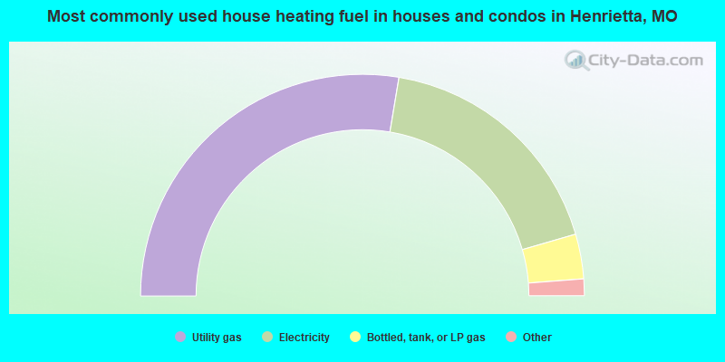
- 56.7%Utility gas
- 36.7%Electricity
- 6.7%Bottled, tank, or LP gas
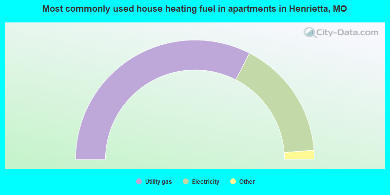
- 66.7%Utility gas
- 33.3%Electricity
Henrietta compared to Missouri state average:
- Median household income below state average.
- Median house value significantly below state average.
- Unemployed percentage significantly below state average.
- Black race population percentage below state average.
- Hispanic race population percentage significantly below state average.
- Length of stay since moving in above state average.
- House age above state average.
- Institutionalized population percentage significantly above state average.
- Number of college students below state average.
- Percentage of population with a bachelor's degree or higher significantly below state average.