Hillsdale, North Carolina
Submit your own pictures of this place and show them to the world
- OSM Map
- Google Map
- MSN Map
| Males: 453 | |
| Females: 531 |
| Median resident age: | 49.8 years |
| North Carolina median age: | 39.2 years |
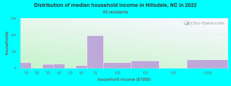
| Hillsdale: | $70,457 |
| NC: | $67,481 |
Estimated per capita income in 2022: $37,600
Hillsdale CDP income, earnings, and wages data
Estimated median house or condo value in 2022: $262,084
| Hillsdale: | $262,084 |
| NC: | $280,600 |
Median gross rent in 2022: $974.
Detailed information about poverty and poor residents in Hillsdale, NC
Compare current foreclosures near your location:
| Photo | Address | Area | Beds / Baths | Price | Details |
|---|---|---|---|---|---|

|
#1
S High St
Columbus, OH 43207
|
1,678 sq. feet
|
2 baths 4 beds |
$31,900
|
show details |

|
#2
E 21st Ave
Columbus, OH 43211
|
1,061 sq. feet
|
1 baths 3 beds |
$179,900
|
show details |

|
#3
Bayberry Cir
Columbus, OH 43207
|
1,564 sq. feet
|
1 baths 3 beds |
$127,500
|
show details |

|
#4
Glenmate Ct
Columbus, OH 43223
|
1,050 sq. feet
|
1 baths 3 beds |
show details | |

|
#5
Hiawatha Park Dr
Columbus, OH 43211
|
1,278 sq. feet
|
1 baths 4 beds |
show details | |

|
#6
Executive Ct
Westerville, OH 43081
|
1,811 sq. feet
|
2 baths 3 beds |
show details | |

|
#7
Chidley St
Galloway, OH 43119
|
1,502 sq. feet
|
1 baths 3 beds |
show details | |

|
#8
E Welch Ave
Columbus, OH 43207
|
1,864 sq. feet
|
2 baths 4 beds |
show details | |

|
#9
S Hague Ave
Columbus, OH 43204
|
979 sq. feet
|
1 baths 2 beds |
show details | |

|
#10
Chester Rd
Columbus, OH 43221
|
3,300 sq. feet
|
4 baths 5 beds |
show details |
| Photo | Address | Area | Beds / Baths | Price | Details |
|---|---|---|---|---|---|

|
#11
S Champion Ave
Columbus, OH 43207
|
1,157 sq. feet
|
1 baths 2 beds |
show details | |

|
#12
E Lincoln Ave
Columbus, OH 43214
|
874 sq. feet
|
1 baths 3 beds |
show details | |

|
#13
Armada Rd
Columbus, OH 43232
|
1,028 sq. feet
|
1 baths 4 beds |
show details | |

|
#14
Lehner Rd
Columbus, OH 43224
|
1,628 sq. feet
|
2 baths 4 beds |
show details | |

|
#15
Kelton Ave
Columbus, OH 43206
|
1,080 sq. feet
|
1 baths 3 beds |
show details | |

|
#16
Fairfield Ave
Columbus, OH 43203
|
984 sq. feet
|
1 baths 2 beds |
show details | |

|
#17
Upton Rd E
Columbus, OH 43232
|
852 sq. feet
|
1 baths 3 beds |
show details | |

|
#18
Brookstone Dr
Westerville, OH 43082
|
1,783 sq. feet
|
3 baths 3 beds |
show details | |

|
#19
E Howard Rd
Columbus, OH 43207
|
1,056 sq. feet
|
1 baths 3 beds |
show details | |

|
#20
Summertree Ln
Westerville, OH 43081
|
2,496 sq. feet
|
2 baths 3 beds |
show details |
| Photo | Address | Area | Beds / Baths | Price | Details |
|---|---|---|---|---|---|

|
#21
N Roys Ave
Columbus, OH 43204
|
1,248 sq. feet
|
2 baths 3 beds |
show details | |

|
#22
Marshrun Dr
Grove City, OH 43123
|
2,036 sq. feet
|
2 baths 4 beds |
show details | |

|
#23
London Groveport Rd
Grove City, OH 43123
|
816 sq. feet
|
1 baths 2 beds |
show details | |

|
#24
Striebel Ct
Columbus, OH 43227
|
925 sq. feet
|
1 baths 3 beds |
show details | |

|
#25
Fergus Rd
Grove City, OH 43123
|
3,312 sq. feet
|
2 baths 4 beds |
show details | |

|
#26
Ashgrove Dr
Grove City, OH 43123
|
1,772 sq. feet
|
2 baths 4 beds |
show details | |

|
#27
Meadowbrook Dr
Columbus, OH 43207
|
1,752 sq. feet
|
2 baths 4 beds |
show details | |

|
#28
Grasmere Ave
Columbus, OH 43211
|
720 sq. feet
|
1 baths 2 beds |
show details | |

|
#29
Whittman Ct
Plain City, OH 43064
|
3,186 sq. feet
|
3 baths 4 beds |
show details | |

|
#30
Hamilton Ave
Columbus, OH 43211
|
1,061 sq. feet
|
1 baths 3 beds |
show details |
| Photo | Address | Area | Beds / Baths | Price | Details |
|---|---|---|---|---|---|

|
#31
S Richardson Ave
Columbus, OH 43204
|
1,520 sq. feet
|
2 baths 3 beds |
show details | |

|
#32
Kingsglen Dr
Grove City, OH 43123
|
1,635 sq. feet
|
2 baths 4 beds |
show details | |

|
#33
Midland Ave
Columbus, OH 43223
|
1,518 sq. feet
|
1 baths 2 beds |
show details | |

|
#34
Elaine Rd
Columbus, OH 43213
|
764 sq. feet
|
1 baths 2 beds |
show details | |

|
#35
High Free Pike
West Jefferson, OH 43162
|
1,216 sq. feet
|
2 baths 4 beds |
show details | |

|
#36
Stoneybrook Blvd # 21a
Hilliard, OH 43026
|
1,231 sq. feet
|
2 baths 3 beds |
show details | |

|
#37
Hildreth Ave
Columbus, OH 43203
|
1,798 sq. feet
|
2 baths 4 beds |
show details | |

|
#38
Scottwood Rd
Columbus, OH 43227
|
1,008 sq. feet
|
1 baths 3 beds |
show details | |

|
#39
N 18th St
Columbus, OH 43203
|
1,690 sq. feet
|
1 baths 4 beds |
show details | |

|
#40
Gladys Rd
Columbus, OH 43228
|
832 sq. feet
|
1 baths 3 beds |
show details |
| Photo | Address | Area | Beds / Baths | Price | Details |
|---|---|---|---|---|---|

|
#41
Falls Peak Ln
Delaware, OH 43015
|
1,352 sq. feet
|
2 baths 2 beds |
show details | |

|
#42
Brookfield Rd
Columbus, OH 43229
|
896 sq. feet
|
1 baths 3 beds |
show details | |

|
#43
Allwood Ct
Columbus, OH 43231
|
1,683 sq. feet
|
2 baths 3 beds |
show details | |

|
#44
Colorado Ave
Groveport, OH 43125
|
1,502 sq. feet
|
1 baths 3 beds |
show details | |

|
#45
Morgan Ln
Columbus, OH 43230
|
4,619 sq. feet
|
5 baths 6 beds |
show details | |

|
#46
Cole Rd
Columbus, OH 43228
|
1,833 sq. feet
|
2 baths 3 beds |
show details | |

|
#47
Bucknell Rd
Columbus, OH 43213
|
1,054 sq. feet
|
1 baths 3 beds |
show details | |

|
#48
Doral Ave
Columbus, OH 43213
|
2,008 sq. feet
|
2 baths 4 beds |
show details | |

|
#49
Belfast Dr
Columbus, OH 43227
|
1,142 sq. feet
|
2 baths 3 beds |
show details | |

|
Check over 1 million property listings on Foreclosure.com!
|
browse all offers | |||

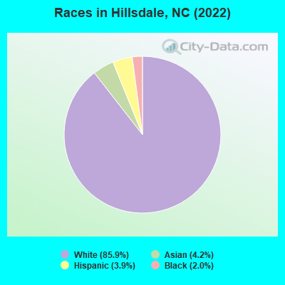
- 77385.9%White alone
- 384.2%Asian alone
- 353.9%Hispanic
- 182.0%Black alone
Races in Hillsdale detailed stats: ancestries, foreign born residents, place of birth
 Recent articles from our blog. Our writers, many of them Ph.D. graduates or candidates, create easy-to-read articles on a wide variety of topics.
Ancestries: Scotch-Irish (29.7%), American (24.3%), German (16.6%), Irish (9.1%), French Canadian (5.0%), Russian (4.3%).
Current Local Time: EST time zone
23 residents are foreign born (2.6% Asia).
| This place: | 2.6% |
| North Carolina: | 100.0% |
Median real estate property taxes paid for housing units with mortgages in 2022: $1,577 (0.6%)
Nearest city with pop. 50,000+: Greenville, NC  (1.4 miles , pop. 60,476).
Nearest city with pop. 200,000+: Raleigh, NC (71.9 miles , pop. 276,093).
Nearest city with pop. 1,000,000+: Philadelphia, PA (328.5 miles , pop. 1,517,550).
Nearest cities:
), ), ), )Latitude: 35.59 N, Longitude: 77.39 W
Area code commonly used in this area: 252
| Here: | 2.8% |
| North Carolina: | 3.2% |
(lower is better)
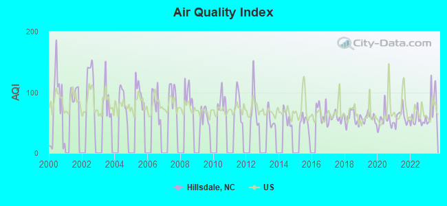
Air Quality Index (AQI) level in 2023 was 77.4. This is about average.
| City: | 77.4 |
| U.S.: | 72.6 |
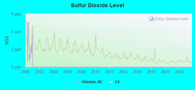
Sulfur Dioxide (SO2) [ppb] level in 2000 was 3.09. This is significantly worse than average. Closest monitor was 1.9 miles away from the city center.
| City: | 3.09 |
| U.S.: | 1.51 |
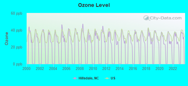
Ozone [ppb] level in 2022 was 29.2. This is about average. Closest monitor was 3.8 miles away from the city center.
| City: | 29.2 |
| U.S.: | 33.3 |
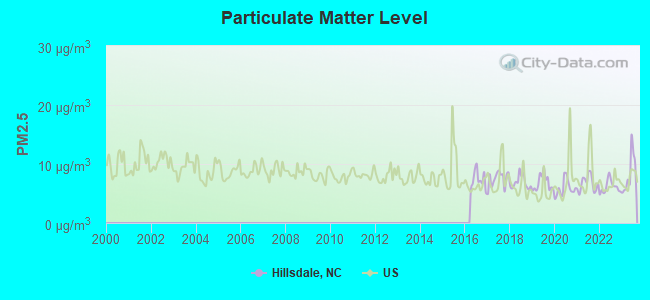
Particulate Matter (PM2.5) [µg/m3] level in 2023 was 8.35. This is about average. Closest monitor was 0.5 miles away from the city center.
| City: | 8.35 |
| U.S.: | 8.11 |
Tornado activity:
Hillsdale-area historical tornado activity is slightly above North Carolina state average. It is 10% greater than the overall U.S. average.
On 3/28/1984, a category F4 (max. wind speeds 207-260 mph) tornado 12.5 miles away from the Hillsdale place center killed 16 people and injured 153 people and caused between $5,000,000 and $50,000,000 in damages.
On 5/15/1972, a category F3 (max. wind speeds 158-206 mph) tornado 1.5 miles away from the place center injured 4 people and caused between $500,000 and $5,000,000 in damages.
Earthquake activity:
Hillsdale-area historical earthquake activity is significantly above North Carolina state average. It is 59% smaller than the overall U.S. average.On 8/23/2011 at 17:51:04, a magnitude 5.8 (5.8 MW, Depth: 3.7 mi, Class: Moderate, Intensity: VI - VII) earthquake occurred 163.0 miles away from Hillsdale center
On 8/9/2020 at 12:07:37, a magnitude 5.1 (5.1 MW, Depth: 4.7 mi) earthquake occurred 215.7 miles away from the city center
On 12/9/2003 at 20:59:14, a magnitude 4.5 (4.5 MB, 4.5 LG, Class: Light, Intensity: IV - V) earthquake occurred 140.8 miles away from the city center
On 12/9/2003 at 20:59:18, a magnitude 4.5 (4.5 ML, Depth: 6.2 mi) earthquake occurred 155.8 miles away from the city center
On 8/25/2011 at 05:07:52, a magnitude 4.5 (4.5 ML, Depth: 4.2 mi) earthquake occurred 165.8 miles away from the city center
On 8/6/1994 at 19:54:09, a magnitude 3.8 (3.6 LG, 3.8 LG, Depth: 3.1 mi, Class: Light, Intensity: II - III) earthquake occurred 51.4 miles away from the city center
Magnitude types: regional Lg-wave magnitude (LG), body-wave magnitude (MB), local magnitude (ML), moment magnitude (MW)
Natural disasters:
The number of natural disasters in Davie County (13) is near the US average (15).Major Disasters (Presidential) Declared: 6
Emergencies Declared: 5
Causes of natural disasters: Hurricanes: 3, Droughts: 2, Winter Storms: 2, Blizzard: 1, Flood: 1, Freeze: 1, Ice Storm: 1, Snowfall: 1, Storm: 1, Tornado: 1, Tropical Storm: 1, Other: 1 (Note: some incidents may be assigned to more than one category).
Hospitals and medical centers near Hillsdale:
- UNIVERSITY HEALTH SYSTEMS HOME HEALTH AND HOSPICE (Home Health Center, about 2 miles away; GREENVILLE, NC)
- FMC DIALYSIS SERVICES EAST CAROLINA UNIVERSITY (Dialysis Facility, about 2 miles away; GREENVILLE, NC)
- GREENFIELD PLACE (Nursing Home, about 2 miles away; GREENVILLE, NC)
- UNIVERSAL HEALTH CARE / GREENVILLE (Nursing Home, about 2 miles away; GREENVILLE, NC)
- GOLDEN LIVINGCENTER - GREENVILLE (Nursing Home, about 2 miles away; GREENVILLE, NC)
- GREENVILLE DIALYSIS CENTER (Dialysis Facility, about 3 miles away; GREENVILLE, NC)
- SKILL CREATIONS OF GREENVILLE (Hospital, about 3 miles away; GREENVILLE, NC)
Colleges/universities with over 2000 students nearest to Hillsdale:
- East Carolina University (about 2 miles; Greenville, NC; Full-time enrollment: 23,943)
- Pitt Community College (about 4 miles; Winterville, NC; FT enrollment: 7,026)
- Edgecombe Community College (about 23 miles; Tarboro, NC; FT enrollment: 2,058)
- Lenoir Community College (about 27 miles; Kinston, NC; FT enrollment: 2,555)
- Wayne Community College (about 34 miles; Goldsboro, NC; FT enrollment: 3,174)
- Craven Community College (about 38 miles; New Bern, NC; FT enrollment: 2,712)
- Nash Community College (about 39 miles; Rocky Mount, NC; FT enrollment: 2,520)
Points of interest:
| This place: | 2.2 people |
| North Carolina: | 2.5 people |
| This place: | 67.4% |
| Whole state: | 66.7% |
| This place: | 5.2% |
| Whole state: | 5.9% |
Likely homosexual households (counted as self-reported same-sex unmarried-partner households)
- Lesbian couples: 0.5% of all households
- Gay men: 0.2% of all households
For population 15 years and over in Hillsdale:
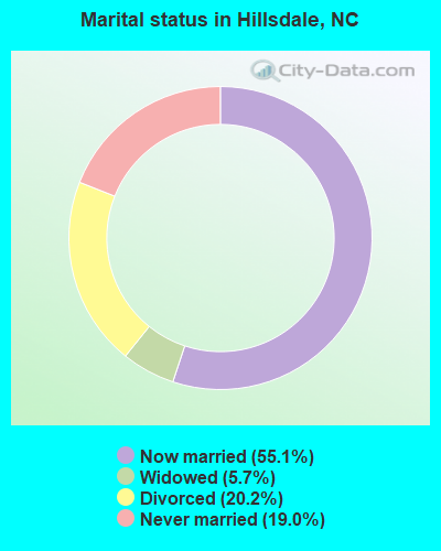
- Never married: 19.0%
- Now married: 55.1%
- Separated: 0.0%
- Widowed: 5.7%
- Divorced: 20.2%
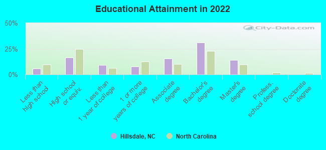
For population 25 years and over in Hillsdale:
- High school or higher: 90.5%
- Bachelor's degree or higher: 35.6%
- Graduate or professional degree: 9.0%
| Here: | 9.8 |
| North Carolina average: | 11.7 |
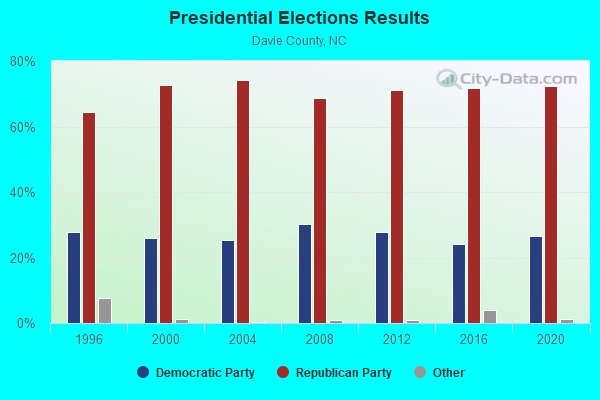
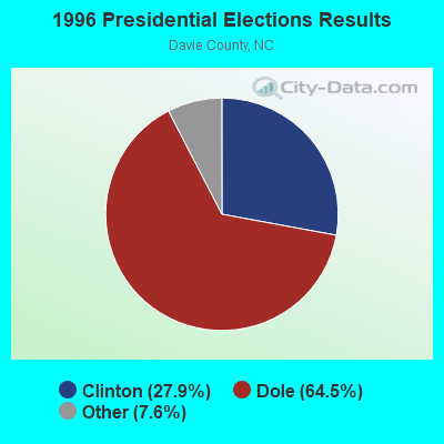


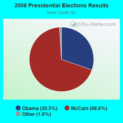

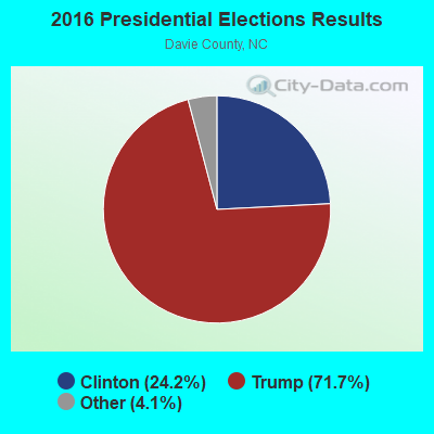
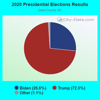
Graphs represent county-level data. Detailed 2008 Election Results
Religion statistics for Hillsdale, NC (based on Davie County data)
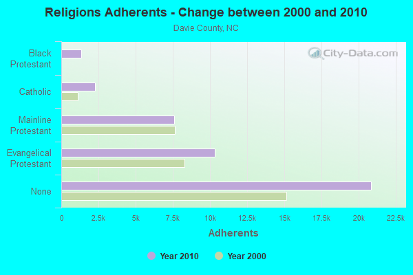
| Religion | Adherents | Congregations |
|---|---|---|
| Evangelical Protestant | 10,339 | 41 |
| Mainline Protestant | 7,608 | 34 |
| Catholic | 2,266 | 1 |
| Black Protestant | 1,337 | 7 |
| Other | 12 | 2 |
| None | 20,864 | - |
Food Environment Statistics:
| Davie County: | 1.98 / 10,000 pop. |
| North Carolina: | 2.05 / 10,000 pop. |
| This county: | 1.24 / 10,000 pop. |
| North Carolina: | 0.92 / 10,000 pop. |
| Davie County: | 3.96 / 10,000 pop. |
| North Carolina: | 4.75 / 10,000 pop. |
| Davie County: | 6.94 / 10,000 pop. |
| State: | 7.57 / 10,000 pop. |
| This county: | 9.6% |
| North Carolina: | 9.8% |
| Davie County: | 27.9% |
| State: | 28.3% |
| This county: | 16.0% |
| State: | 15.6% |
Strongest AM radio stations in Hillsdale:
- WNCT (1070 AM; 10 kW; GREENVILLE, NC; Owner: WNCT LICENSE LIMITED PARTNERSHIP)
- WOOW (1340 AM; 1 kW; GREENVILLE, NC; Owner: THE MINORITY VOICE, INC.)
- WGHB (1250 AM; 5 kW; FARMVILLE, NC; Owner: CONNER MEDIA, INC.)
- WDLX (930 AM; 5 kW; WASHINGTON, NC; Owner: NM LICENSING, LLC)
- WPTF (680 AM; 50 kW; RALEIGH, NC; Owner: FIRST STATE COMMUNICATIONS)
- WRNS (960 AM; 5 kW; KINSTON, NC; Owner: NM LICENSING, LLC)
- WFTK (1030 AM; daytime; 50 kW; WAKE FOREST, NC; Owner: POSITIVE RADIO GROUP, INC.)
- WGTM (590 AM; 5 kW; WILSON, NC; Owner: SPIRIT BROADCASTING, INC.)
- WTAR (850 AM; 50 kW; NORFOLK, VA; Owner: SINCLAIR COMMUNICATIONS)
- WSMO (1120 AM; 20 kW; CAMP LEJEUNE, NC; Owner: CTC MEDIA GROUP, INC.)
- WCKO (1110 AM; daytime; 50 kW; NORFOLK, VA; Owner: WORD BROADCASTING NETWORK, INC.)
- WETC (540 AM; 8 kW; WENDELL-ZEBULON, NC; Owner: CAROLINA REGIONAL BROADCASTING CORPORATION)
- WDJS (1430 AM; 10 kW; MOUNT OLIVE, NC; Owner: MOUNT OLIVE BROADCASTING CO.)
Strongest FM radio stations in Hillsdale:
- WZMB (91.3 FM; GREENVILLE, NC; Owner: EAST CAROLINA UNIVERSITY STUDENT MEDIA BOARD)
- WGPM (94.3 FM; FARMVILLE, NC; Owner: ABG NORTH CAROLINA, LLC)
- W201AO (88.1 FM; GREENVILLE, NC; Owner: CRAVEN COMMUNITY COLLEGE)
- WERO (93.3 FM; WASHINGTON, NC; Owner: NM LICENSING, LLC)
- WNCT-FM (107.9 FM; GREENVILLE, NC; Owner: WNCT LICENSE LIMITED PARTNERSHIP)
- W287AH (105.3 FM; GREENVILLE, NC; Owner: BIBLE BROADCASTING NETWORK, INC.)
- WTRG (100.7 FM; ROCKY MOUNT, NC; Owner: CAPSTAR TX LIMITED PARTNERSHIP)
- WRNS-FM (95.1 FM; KINSTON, NC; Owner: NM LICENSING, LLC)
- WFXK (104.3 FM; TARBORO, NC; Owner: RADIO ONE LICENSES, LLC)
- WIKS (101.9 FM; NEW BERN, NC; Owner: WIKS LICENSE LIMITED PARTNERSHIP)
- WAGO (88.7 FM; SNOW HILL, NC; Owner: PATHWAY CHRISTIAN ACADEMY, INC.)
- WCBZ (103.7 FM; WILLIAMSTON, NC; Owner: ABG NORTH CAROLINA, LLC)
- WRDU (106.1 FM; WILSON, NC; Owner: CAPSTAR TX LIMITED PARTNERSHIP)
- WXNR (99.5 FM; GRIFTON, NC; Owner: WXNR LICENSE LIMITED PARTNERSHIP)
- WRQM (90.9 FM; ROCKY MOUNT, NC; Owner: BOARD OF TRUSTEES UNIVERSITY OF NC AT CHAPEL HILL)
- WCZI (98.3 FM; WASHINGTON, NC; Owner: ABG NORTH CAROLINA, LLC)
- W208AO (89.5 FM; BELL ARTHUR, NC; Owner: GRACE MISSIONARY BAPTIST CHURCH)
- WRSV (92.1 FM; ROCKY MOUNT, NC; Owner: NORTHSTAR BROADCATING CORPORATION)
- WSFL-FM (106.5 FM; NEW BERN, NC; Owner: WSFL LICENSE LIMITED PARTNERSHIP)
- W240AZ (95.9 FM; GREENVILLE, NC; Owner: RADIO TRAINING NETWORK, INC.)
TV broadcast stations around Hillsdale:
- WITN-TV (Channel 7; WASHINGTON, NC; Owner: WITN LICENSEE CORP.)
- WNCT-TV (Channel 9; GREENVILLE, NC; Owner: MEDIA GENERAL COMMUNICATIONS, INC.)
- W60CV (Channel 60; GREENVILLE, NC; Owner: TRINITY BROADCASTING NETWORK)
- WUNK-TV (Channel 25; GREENVILLE, NC; Owner: UNIVERSITY OF NORTH CAROLINA)
- WYDO (Channel 14; GREENVILLE, NC; Owner: PIEDMONT TELEVISION OF EASTERN CAROLINA LICENSE LLC)
- WCTI-TV (Channel 12; NEW BERN, NC; Owner: EASTERN NORTH CAROLINA BROADCASTING CORPORATION)
- WUNM-TV (Channel 19; JACKSONVILLE, NC; Owner: UNIVERSITY OF NORTH CAROLINA)
- WEPX (Channel 38; GREENVILLE, NC; Owner: PAXSON GREENVILLE LICENSE, INC.)
- WRAY-TV (Channel 30; WILSON, NC; Owner: WRAY, INC.)
- WNCN (Channel 17; GOLDSBORO, NC; Owner: OUTLET BROADCASTING, INC.)
- WRPX (Channel 47; ROCKY MOUNT, NC; Owner: PAXSON RALEIGH LICENSE, INC.)
- WFTB-LP (Channel 55; WILLIAMSTON, ETC., NC; Owner: FREE TEMPLE MINISTRIES, INC.)
- W64AZ (Channel 64; KINSTON-GREENVILLE, NC; Owner: GOCOM TELEVISION, L.P.,)
- WNCR-LP (Channel 20; WILSON, NC; Owner: ON THE MAP, INC.)
Hillsdale fatal accident list:
Jun 11, 2016 12:27 AM, I-40, Lat: 36.006058, Lon: -80.445111, Vehicles: 3, Persons: 6, Fatalities: 1
Dec 15, 2000 08:10 PM, I-40, Lat: 36.007969, Lon: -80.438564, Vehicles: 2, Persons: 2, Fatalities: 1
FCC Registered Antenna Towers:
4- Auilda M Rodriguez, 875 Rainbow Road (Lat: 35.984167 Lon: -80.476389), Type: 96.0, Overall height: 96 m, Registrant: Nextel Communications, Jeffrey.Haskins@nextel.Com, , Resto-n, Phone: (703) 433-4000
- Jeffrey S Haskins, 875 Rainbow Road (Lat: 35.984167 Lon: -80.476389), Type: 96.0, Overall height: 96 m, Registrant: Nextel Communications, Jeffrey.Haskins@nextel.Com, , Resto-n, Phone: (703) 433-4000
- Kyle B Entz, 875 Rainbow Road (Lat: 35.984167 Lon: -80.476389), Type: 96.0, Overall height: 96 m, Registrant: Nextel Communications, Jeffrey.Haskins@nextel.Com, , Resto-n, Phone: (703) 433-4000
- 875 Rainbow Road (Lat: 35.984167 Lon: -80.476389), Type: 96.0, Overall height: 96 m, Registrant: Nextel Communications, Fran.Kennedy@nextel.Com, , Cary, Phone: (919) 461-2155
FCC Registered Microwave Towers:
1- ADVANCE, Sr 801 & I-40 (Lat: 36.003167 Lon: -80.452833), Overall height: 91.4 m, Call Sign: WMQ251,
Assigned Frequencies: 2174.80 MHz, Grant Date: 03/06/2001, Expiration Date: 02/01/2011, Cancellation Date: 03/14/2008, Certifier: Glenn S Rabin, Registrant: Alltel Communications, LLC, One Allied Drive, B1f02-D, Little Rock, AR 72202, Phone: (501) 905-8555, Fax: (501) 905-6193, Email:
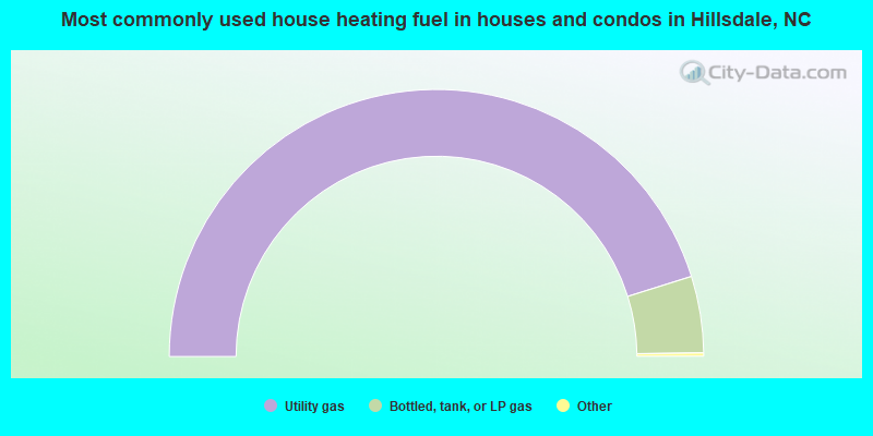
- 90.7%Utility gas
- 9.3%Bottled, tank, or LP gas
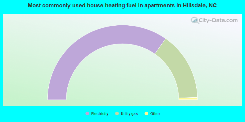
- 70.2%Electricity
- 29.8%Utility gas
Hillsdale compared to North Carolina state average:
- Unemployed percentage significantly below state average.
- Black race population percentage significantly below state average.
- Hispanic race population percentage significantly below state average.
- Median age below state average.
- Foreign-born population percentage significantly below state average.
- Length of stay since moving in significantly above state average.
- House age significantly below state average.
- Institutionalized population percentage significantly above state average.