Hobart, Wisconsin
Submit your own pictures of this town and show them to the world
- OSM Map
- General Map
- Google Map
- MSN Map

Population change since 2000: +107.0%
| Males: 5,253 | |
| Females: 5,282 |
| Median resident age: | 38.9 years |
| Wisconsin median age: | 40.4 years |
Zip codes: 54313.
| Hobart: | $102,967 |
| WI: | $70,996 |
Estimated per capita income in 2022: $58,342 (it was $29,059 in 2000)
Hobart town income, earnings, and wages data
Estimated median house or condo value in 2022: $369,565 (it was $178,600 in 2000)
| Hobart: | $369,565 |
| WI: | $252,800 |
Mean prices in 2022: all housing units: $410,181; detached houses: $416,549
Median gross rent in 2022: $1,049.
(3.3% for White Non-Hispanic residents, 16.1% for American Indian residents, 1.2% for two or more races residents)
Detailed information about poverty and poor residents in Hobart, WI
Compare current foreclosures near Hobart, WI:
| Photo | Address | Area | Beds / Baths | Price | Details |
|---|---|---|---|---|---|

|
#1
S Norwood Ave
Green Bay, WI 54304
|
- sq. feet
|
- baths - beds |
$36,900
|
show details |

|
#2
Sumac Pl
Green Bay, WI 54313
|
4,704 sq. feet
|
5 baths 5 beds |
show details | |

|
#3
Aspen Ln
Green Bay, WI 54303
|
- sq. feet
|
1 baths 3 beds |
show details | |

|
#4
Wirtz Ave
Green Bay, WI 54304
|
- sq. feet
|
- baths - beds |
$15,000
|
show details |

|
#5
3rd St
Green Bay, WI 54304
|
- sq. feet
|
- baths - beds |
$60,000
|
show details |

|
#6
S Superior St
De Pere, WI 54115
|
- sq. feet
|
- baths - beds |
show details | |

|
#7
S Broadway
De Pere, WI 54115
|
- sq. feet
|
- baths - beds |
show details | |

|
#8
S Jackson St
Green Bay, WI 54301
|
- sq. feet
|
- baths - beds |
show details | |

|
#9
N Washington St Apt 120
Green Bay, WI 54301
|
- sq. feet
|
- baths - beds |
show details | |

|
#10
Quarry Park Dr, Apt 5
De Pere, WI 54115
|
- sq. feet
|
- baths - beds |
show details |
| Photo | Address | Area | Beds / Baths | Price | Details |
|---|---|---|---|---|---|

|
#11
N Washington St Apt 426
Green Bay, WI 54301
|
- sq. feet
|
- baths - beds |
show details | |

|
#12
Laverne Dr
Green Bay, WI 54311
|
- sq. feet
|
- baths - beds |
show details | |

|
#13
Quarry Park Dr, Apt 4
De Pere, WI 54115
|
- sq. feet
|
- baths - beds |
show details | |

|
#14
James St Apt 2
Green Bay, WI 54303
|
- sq. feet
|
- baths - beds |
show details | |

|
#15
S Timber Trl
Suamico, WI 54173
|
- sq. feet
|
- baths - beds |
show details | |

|
#16
E Walnut St, Apt 310
Green Bay, WI 54301
|
- sq. feet
|
- baths - beds |
show details | |

|
#17
Don Gerard Way
Green Bay, WI 54311
|
- sq. feet
|
- baths - beds |
show details | |

|
#18
E Paris Way Apt 12
Appleton, WI 54913
|
- sq. feet
|
- baths - beds |
show details | |

|
#19
S Timber Trl
Suamico, WI 54173
|
- sq. feet
|
- baths - beds |
show details | |

|
#20
County Road Ee
Appleton, WI 54913
|
- sq. feet
|
- baths - beds |
show details |
| Photo | Address | Area | Beds / Baths | Price | Details |
|---|---|---|---|---|---|

|
#21
Le Brun Rd
De Pere, WI 54115
|
- sq. feet
|
- baths - beds |
show details | |

|
#22
Voelker St
De Pere, WI 54115
|
- sq. feet
|
- baths - beds |
show details | |

|
#23
Emilie St
Green Bay, WI 54301
|
- sq. feet
|
- baths - beds |
show details | |

|
#24
Snow Shoe Trl
Suamico, WI 54173
|
- sq. feet
|
- baths - beds |
show details | |

|
#25
Pershing Rd Unit 117
De Pere, WI 54115
|
- sq. feet
|
- baths - beds |
show details | |

|
#26
Arctic Ct
Suamico, WI 54173
|
- sq. feet
|
- baths - beds |
show details | |

|
#27
Ridgeway Dr Apt 66
De Pere, WI 54115
|
- sq. feet
|
- baths - beds |
show details | |

|
#28
W Point Rd
Green Bay, WI 54313
|
- sq. feet
|
- baths - beds |
show details | |

|
#29
E Walnut St
Green Bay, WI 54301
|
- sq. feet
|
- baths - beds |
show details | |

|
#30
Harvey St
Green Bay, WI 54302
|
- sq. feet
|
- baths - beds |
show details |
| Photo | Address | Area | Beds / Baths | Price | Details |
|---|---|---|---|---|---|

|
#31
E Shore Dr
Green Bay, WI 54302
|
- sq. feet
|
- baths - beds |
show details | |

|
#32
S 6th St
De Pere, WI 54115
|
- sq. feet
|
- baths - beds |
show details | |

|
#33
N Chestnut Ave
Green Bay, WI 54303
|
- sq. feet
|
- baths - beds |
show details | |

|
#34
Velp Ave
Green Bay, WI 54303
|
- sq. feet
|
- baths - beds |
show details | |

|
#35
Redstone Trl Apt 4
Green Bay, WI 54313
|
- sq. feet
|
- baths - beds |
show details | |

|
#36
Vroman St
Green Bay, WI 54303
|
- sq. feet
|
- baths - beds |
show details | |

|
#37
S Huron Rd Apt 71
Green Bay, WI 54311
|
- sq. feet
|
- baths - beds |
show details | |

|
#38
Laurel Ln
Green Bay, WI 54311
|
- sq. feet
|
- baths - beds |
show details | |

|
#39
Oakton Ln
Green Bay, WI 54311
|
- sq. feet
|
- baths - beds |
show details | |

|
#40
Mollies Way
De Pere, WI 54115
|
- sq. feet
|
- baths - beds |
show details |
| Photo | Address | Area | Beds / Baths | Price | Details |
|---|---|---|---|---|---|

|
#41
Allouez Ave
Green Bay, WI 54311
|
- sq. feet
|
- baths - beds |
show details | |

|
#42
Lawrence Dr # 1
De Pere, WI 54115
|
- sq. feet
|
- baths - beds |
show details | |

|
#43
Lourdes Ave # 11
De Pere, WI 54115
|
- sq. feet
|
- baths - beds |
show details | |

|
#44
Crown Ct
De Pere, WI 54115
|
- sq. feet
|
- baths - beds |
show details | |

|
#45
Grant St # 11
De Pere, WI 54115
|
- sq. feet
|
- baths - beds |
show details | |

|
#46
S Franco Ct
De Pere, WI 54115
|
- sq. feet
|
- baths - beds |
show details | |

|
#47
Cherry St
Green Bay, WI 54301
|
- sq. feet
|
- baths - beds |
show details | |

|
#48
N Front St Apt 117
De Pere, WI 54115
|
- sq. feet
|
- baths - beds |
show details | |

|
#49
Cornelius Dr
Green Bay, WI 54311
|
- sq. feet
|
- baths - beds |
show details | |

|
Check over 1 million property listings on Foreclosure.com!
|
browse all offers | |||


- 7,41072.7%White alone
- 9949.8%Two or more races
- 6506.4%American Indian alone
- 4914.8%Asian alone
- 4124.0%Hispanic
- 2422.4%Other race alone
- 130.1%Native Hawaiian and Other
Pacific Islander alone
Races in Hobart detailed stats: ancestries, foreign born residents, place of birth
According to our research of Wisconsin and other state lists, there were 3 registered sex offenders living in Hobart, Wisconsin as of May 15, 2024.
The ratio of all residents to sex offenders in Hobart is 2,631 to 1.
The ratio of registered sex offenders to all residents in this city is much lower than the state average.
 Recent articles from our blog. Our writers, many of them Ph.D. graduates or candidates, create easy-to-read articles on a wide variety of topics.
Ancestries: German (29.8%), Irish (8.6%), Polish (6.2%), American (5.7%), Belgian (3.0%), Eastern European (2.7%).
Current Local Time: CST time zone
Land area: 33.2 square miles.
Population density: 318 people per square mile (very low).

237 residents are foreign born (2.0% Asia, 0.4% Europe).
| This town: | 2.3% |
| Wisconsin: | 5.0% |
Median real estate property taxes paid for housing units with mortgages in 2022: $4,649 (1.2%)
Median real estate property taxes paid for housing units with no mortgage in 2022: $4,097 (1.3%)
Nearest city with pop. 50,000+: Green Bay, WI  (6.3 miles , pop. 102,313).
Nearest city with pop. 200,000+: Milwaukee, WI (101.5 miles , pop. 596,974).
Nearest city with pop. 1,000,000+: Chicago, IL (186.4 miles , pop. 2,896,016).
Nearest cities:
), ), )Latitude: 44.51 N, Longitude: 88.14 W
Area code commonly used in this area: 920
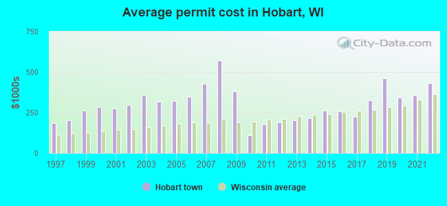
Single-family new house construction building permits:
- 2022: 63 buildings, average cost: $434,200
- 2021: 39 buildings, average cost: $356,500
- 2020: 40 buildings, average cost: $341,800
- 2019: 27 buildings, average cost: $461,400
- 2018: 24 buildings, average cost: $326,100
- 2017: 70 buildings, average cost: $224,400
- 2016: 67 buildings, average cost: $257,900
- 2015: 41 buildings, average cost: $263,600
- 2014: 64 buildings, average cost: $215,100
- 2013: 80 buildings, average cost: $201,900
- 2012: 102 buildings, average cost: $189,900
- 2011: 60 buildings, average cost: $176,500
- 2010: 45 buildings, average cost: $111,400
- 2009: 3 buildings, average cost: $382,600
- 2008: 7 buildings, average cost: $570,000
- 2007: 15 buildings, average cost: $426,600
- 2006: 12 buildings, average cost: $347,300
- 2005: 29 buildings, average cost: $321,400
- 2004: 46 buildings, average cost: $315,700
- 2003: 78 buildings, average cost: $361,400
- 2002: 55 buildings, average cost: $297,500
- 2001: 66 buildings, average cost: $274,200
- 2000: 52 buildings, average cost: $283,500
- 1999: 60 buildings, average cost: $261,000
- 1998: 53 buildings, average cost: $205,100
- 1997: 31 buildings, average cost: $187,200
| Here: | 2.4% |
| Wisconsin: | 2.7% |
- Health care (10.4%)
- Educational services (8.2%)
- Paper (6.8%)
- Finance & insurance (6.1%)
- Public administration (6.0%)
- Construction (5.9%)
- Arts, entertainment, recreation (4.6%)
- Construction (9.9%)
- Paper (9.4%)
- Health care (7.9%)
- Public administration (6.2%)
- Department & other general merchandise stores (4.0%)
- Machinery (3.9%)
- Finance & insurance (3.7%)
- Educational services (13.9%)
- Health care (13.2%)
- Finance & insurance (8.7%)
- Arts, entertainment, recreation (6.3%)
- Public administration (5.9%)
- Professional, scientific, technical services (5.4%)
- Department & other general merchandise stores (4.2%)
- Other sales and related occupations, including supervisors (7.5%)
- Other management occupations, except farmers and farm managers (6.8%)
- Sales representatives, services, wholesale and manufacturing (4.5%)
- Other production occupations, including supervisors (4.2%)
- Top executives (3.5%)
- Retail sales workers, except cashiers (2.8%)
- Metal workers and plastic workers (2.8%)
- Other sales and related occupations, including supervisors (9.3%)
- Other management occupations, except farmers and farm managers (8.1%)
- Top executives (5.9%)
- Other production occupations, including supervisors (5.4%)
- Metal workers and plastic workers (4.5%)
- Physicians and surgeons (4.4%)
- Construction traders workers except carpenters, electricians, painters, plumbers, and construction laborers (3.9%)
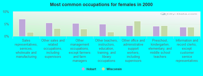
- Sales representatives, services, wholesale and manufacturing (7.0%)
- Other sales and related occupations, including supervisors (5.5%)
- Other management occupations, except farmers and farm managers (5.3%)
- Other teachers, instructors, education, training, and library occupations (5.0%)
- Other office and administrative support workers, including supervisors (4.3%)
- Preschool, kindergarten, elementary, and middle school teachers (4.2%)
- Information and record clerks, except customer service representatives (3.7%)
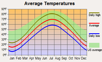
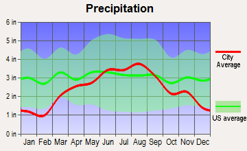
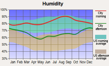
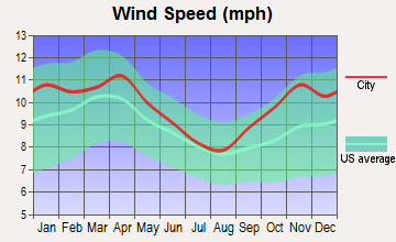
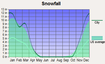
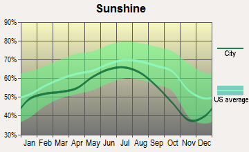
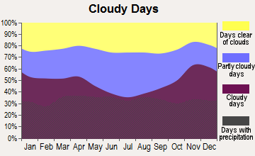
Average climate in Hobart, Wisconsin
Based on data reported by over 4,000 weather stations
(lower is better)
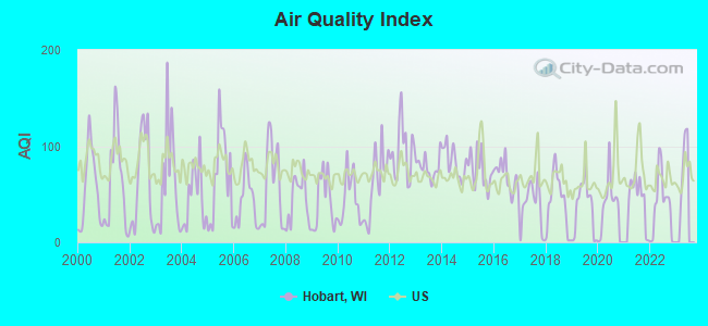
Air Quality Index (AQI) level in 2022 was 37.4. This is significantly better than average.
| City: | 37.4 |
| U.S.: | 72.6 |
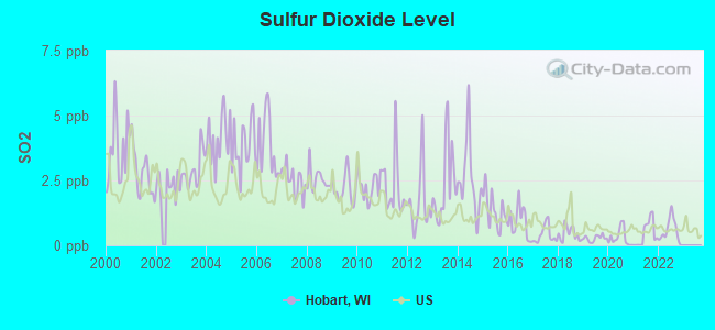
Sulfur Dioxide (SO2) [ppb] level in 2022 was 0.556. This is significantly better than average. Closest monitor was 5.4 miles away from the city center.
| City: | 0.556 |
| U.S.: | 1.515 |
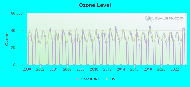
Ozone [ppb] level in 2022 was 31.8. This is about average. Closest monitor was 4.1 miles away from the city center.
| City: | 31.8 |
| U.S.: | 33.3 |
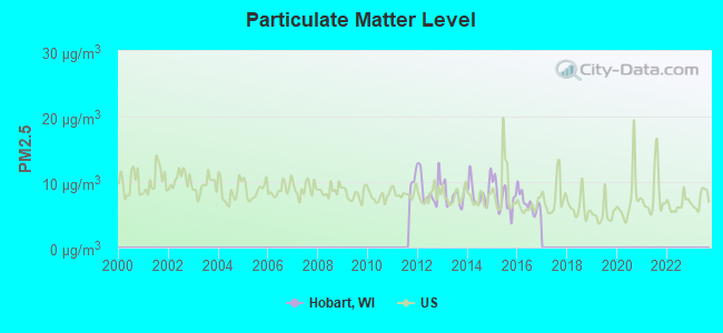
Particulate Matter (PM2.5) [µg/m3] level in 2016 was 6.83. This is about average. Closest monitor was 7.0 miles away from the city center.
| City: | 6.83 |
| U.S.: | 8.11 |
Tornado activity:
Hobart-area historical tornado activity is slightly below Wisconsin state average. It is 4% smaller than the overall U.S. average.
On 4/27/1984, a category F4 (max. wind speeds 207-260 mph) tornado 8.9 miles away from the Hobart town center killed one person and injured 19 people and caused between $500,000 and $5,000,000 in damages.
On 7/5/1994, a category F4 tornado 22.7 miles away from the town center injured 2 people and caused between $500,000 and $5,000,000 in damages.
Earthquake activity:
Hobart-area historical earthquake activity is significantly above Wisconsin state average. It is 22% smaller than the overall U.S. average.On 5/2/2015 at 16:23:07, a magnitude 4.2 (4.2 MW, Depth: 2.8 mi, Class: Light, Intensity: IV - V) earthquake occurred 208.4 miles away from the city center
On 4/18/2008 at 09:36:59, a magnitude 5.4 (5.1 MB, 4.8 MS, 5.4 MW, 5.2 MW, Class: Moderate, Intensity: VI - VII) earthquake occurred 419.5 miles away from the city center
On 6/28/2004 at 06:10:52, a magnitude 4.2 (4.2 MW, Depth: 6.2 mi) earthquake occurred 214.7 miles away from the city center
On 6/10/1987 at 23:48:54, a magnitude 5.1 (4.9 MB, 4.4 MS, 4.6 MS, 5.1 LG) earthquake occurred 394.0 miles away from the city center
On 2/10/2010 at 09:59:35, a magnitude 3.8 (3.8 MW, Depth: 6.2 mi, Class: Light, Intensity: II - III) earthquake occurred 176.9 miles away from Hobart center
On 4/18/2008 at 09:36:59, a magnitude 5.2 (5.2 MW, Depth: 8.9 mi) earthquake occurred 419.5 miles away from Hobart center
Magnitude types: regional Lg-wave magnitude (LG), body-wave magnitude (MB), surface-wave magnitude (MS), moment magnitude (MW)
Natural disasters:
The number of natural disasters in Brown County (7) is smaller than the US average (15).Major Disasters (Presidential) Declared: 5
Emergencies Declared: 2
Causes of natural disasters: Floods: 4, Storms: 4, Tornadoes: 2, Drought: 1, Hurricane: 1, Other: 1 (Note: some incidents may be assigned to more than one category).
Hospitals and medical centers near Hobart:
- SOUTHERNCARE GREEN BAY (Hospital, about 4 miles away; GREEN BAY, WI)
- ST MARYS HSPTL MED CTR Acute Care Hospitals (about 4 miles away; GREEN BAY, WI)
- AMERICANA NURSING CENTER-WEST (Nursing Home, about 4 miles away; GREEN BAY, WI)
- GOLDEN LIVINGCENTER-VILLAGE GARDENS (Nursing Home, about 4 miles away; GREEN BAY, WI)
- MANORCARE HEALTH SERVICES-WEST (Nursing Home, about 4 miles away; GREEN BAY, WI)
- DAVITA - TITLE TOWN (Dialysis Facility, about 4 miles away; GREEN BAY, WI)
- WOODSIDE LUTHERAN HOME (Nursing Home, about 4 miles away; GREEN BAY, WI)
Colleges/universities with over 2000 students nearest to Hobart:
- Northeast Wisconsin Technical College (about 3 miles; Green Bay, WI; Full-time enrollment: 6,069)
- Saint Norbert College (about 7 miles; De Pere, WI; FT enrollment: 2,324)
- University of Wisconsin-Green Bay (about 12 miles; Green Bay, WI; FT enrollment: 5,415)
- Lawrence University (about 22 miles; Appleton, WI; FT enrollment: 2,821)
- Fox Valley Technical College (about 23 miles; Appleton, WI; FT enrollment: 5,682)
- University of Wisconsin-Oshkosh (about 40 miles; Oshkosh, WI; FT enrollment: 10,637)
- Lakeland College (about 49 miles; Plymouth, WI; FT enrollment: 2,395)
Points of interest:
Notable locations in Hobart: Oneida Apple Orchard (A), Hobart Volunteer Fire Department Station 1 (B), Hobart Volunteer Fire Department Station 2 (C), Mayflower Greenhouse (D). Display/hide their locations on the map
Church in Hobart: Holy Apostles Church (A). Display/hide its location on the map
Cemetery: Zion Cemetery (1). Display/hide its location on the map
Drinking water stations with addresses in Hobart and their reported violations in the past:
HOBART WATERWORKS S A 1 (Population served: 1,600, Purch surface water):Past monitoring violations:HOBART WATERWORKS S A 2 (Population served: 350, Purch surface water):
- Monitoring and Reporting (DBP) - Between JAN-2014 and MAR-2014, Contaminant: Total Haloacetic Acids (HAA5). Follow-up actions: St Public Notif requested (APR-30-2014), St Violation/Reminder Notice (APR-30-2014), St Public Notif received (JUN-20-2014)
- Monitoring and Reporting (DBP) - Between OCT-2013 and DEC-2013, Contaminant: Total Haloacetic Acids (HAA5). Follow-up actions: St Public Notif requested (APR-30-2014), St Violation/Reminder Notice (APR-30-2014), St Compliance achieved (MAY-06-2014)
- Monitoring and Reporting (DBP) - Between JUL-2013 and SEP-2013, Contaminant: Total Haloacetic Acids (HAA5). Follow-up actions: St Public Notif requested (APR-30-2014), St Violation/Reminder Notice (APR-30-2014), St Compliance achieved (MAY-06-2014)
- Lead Consumer Notice - In APR-01-2013, Contaminant: Lead and Copper Rule. Follow-up actions: St Other (APR-12-2013), St Compliance achieved (JUL-01-2013), St Public Notif received (JUL-01-2013)
- Monitoring and Reporting (DBP) - Between APR-2013 and JUN-2013, Contaminant: TTHM. Follow-up actions: St Public Notif requested (MAY-31-2013), St Violation/Reminder Notice (MAY-31-2013), St Public Notif received (JUL-01-2013), St Compliance achieved (AUG-06-2013)
- 5 other older monitoring violations
Past monitoring violations:HOBART WATERWORKS S A 3 (Population served: 100, Purch surface water):
- Monitoring and Reporting (DBP) - Between JAN-2013 and DEC-2013, Contaminant: TTHM. Follow-up actions: St Public Notif requested (MAY-01-2014), St Violation/Reminder Notice (MAY-01-2014), St Public Notif received (JUN-20-2014)
Past monitoring violations:
- Monitoring and Reporting (DBP) - Between JAN-2013 and DEC-2013, Contaminant: TTHM. Follow-up actions: St Public Notif requested (MAY-01-2014), St Violation/Reminder Notice (MAY-01-2014), St Public Notif received (JUN-20-2014)
- Follow-up Or Routine LCR Tap M/R - In JAN-01-2008, Contaminant: Lead and Copper Rule. Follow-up actions: St Public Notif requested (AUG-19-2008), St Violation/Reminder Notice (AUG-19-2008), St Compliance achieved (AUG-25-2008), St Public Notif received (JUN-26-2009)
| This town: | 2.8 people |
| Wisconsin: | 2.4 people |
| This town: | 83.9% |
| Whole state: | 64.4% |
| This town: | 4.9% |
| Whole state: | 7.3% |
Likely homosexual households (counted as self-reported same-sex unmarried-partner households)
- Lesbian couples: 0.4% of all households
- Gay men: 0.3% of all households
For population 15 years and over in Hobart:
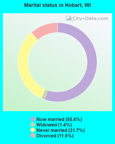
- Never married: 31.7%
- Now married: 55.4%
- Separated: 0.1%
- Widowed: 1.4%
- Divorced: 11.5%
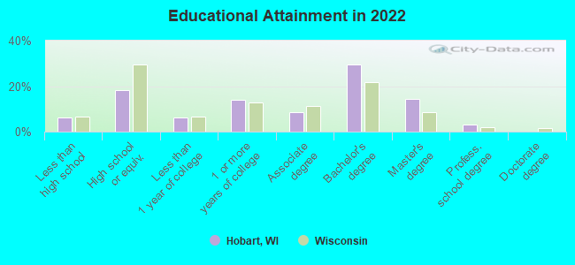
For population 25 years and over in Hobart:
- High school or higher: 93.2%
- Bachelor's degree or higher: 45.9%
- Graduate or professional degree: 15.2%
- Unemployed: 2.0%
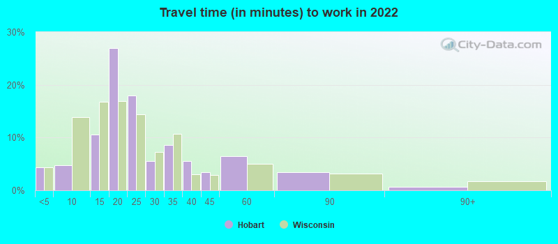
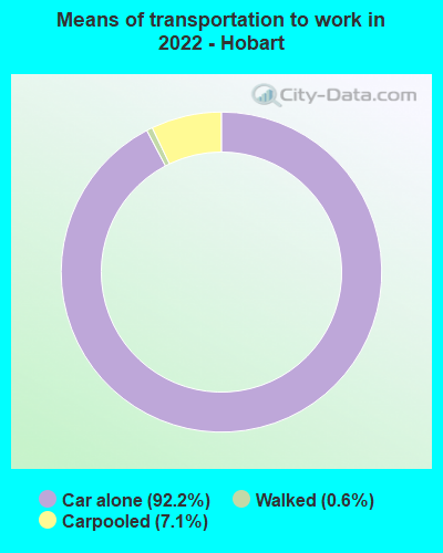
- Mean travel time to work (commute): 15.6 minutes
| Here: | 9.6 |
| Wisconsin average: | 10.4 |
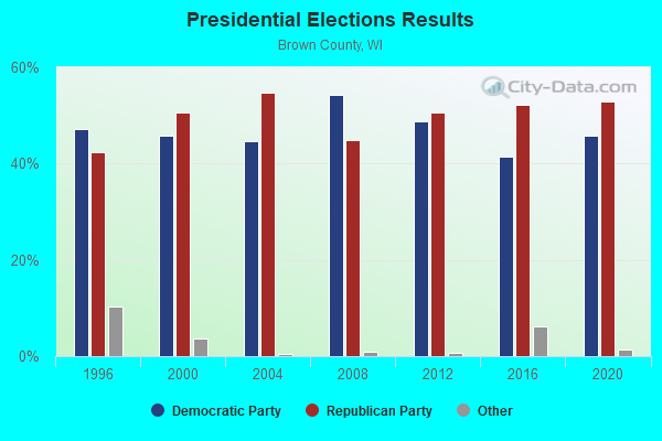
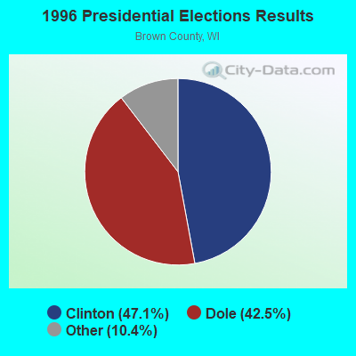
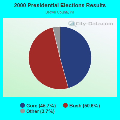
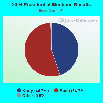
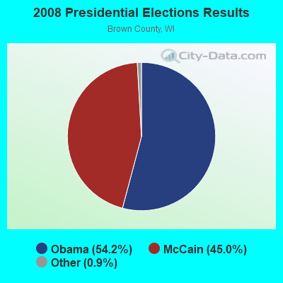
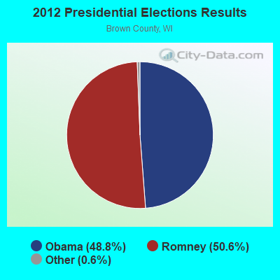
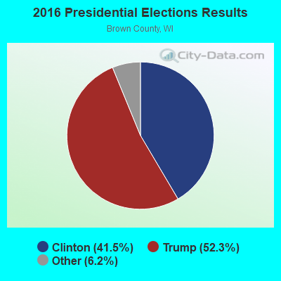

Graphs represent county-level data. Detailed 2008 Election Results
Religion statistics for Hobart, WI (based on Brown County data)
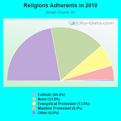
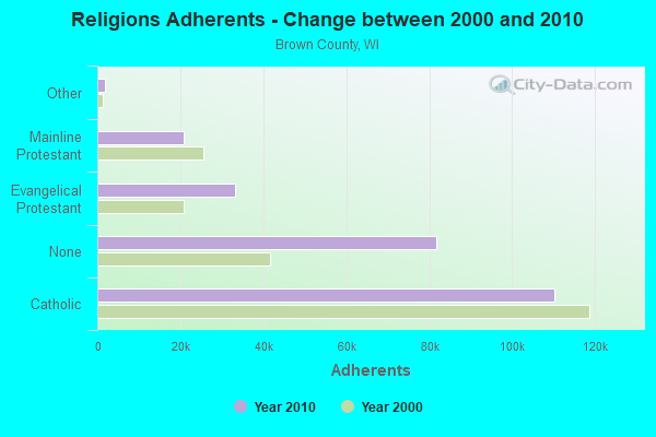
| Religion | Adherents | Congregations |
|---|---|---|
| Catholic | 110,123 | 35 |
| Evangelical Protestant | 33,156 | 79 |
| Mainline Protestant | 20,941 | 40 |
| Other | 1,913 | 12 |
| Orthodox | 100 | 1 |
| None | 81,774 | - |
Food Environment Statistics:
| Here: | 1.36 / 10,000 pop. |
| Wisconsin: | 1.86 / 10,000 pop. |
| Brown County: | 0.12 / 10,000 pop. |
| State: | 0.11 / 10,000 pop. |
| Brown County: | 0.29 / 10,000 pop. |
| Wisconsin: | 0.38 / 10,000 pop. |
| Brown County: | 3.74 / 10,000 pop. |
| Wisconsin: | 4.12 / 10,000 pop. |
| Brown County: | 8.43 / 10,000 pop. |
| Wisconsin: | 8.64 / 10,000 pop. |
| This county: | 7.0% |
| State: | 7.6% |
| Brown County: | 26.7% |
| Wisconsin: | 27.5% |
| Here: | 13.1% |
| Wisconsin: | 13.0% |
Health and Nutrition:
| This city: | 55.5% |
| Wisconsin: | 49.5% |
| Here: | 56.5% |
| Wisconsin: | 46.6% |
| Hobart: | 28.3 |
| State: | 28.7 |
| Hobart: | 20.4% |
| Wisconsin: | 21.4% |
| Here: | 9.6% |
| Wisconsin: | 10.2% |
| Hobart: | 7.0 |
| Wisconsin: | 6.8 |
| Here: | 38.0% |
| Wisconsin: | 34.0% |
| Hobart: | 61.6% |
| State: | 56.3% |
| This city: | 83.9% |
| Wisconsin: | 78.5% |
More about Health and Nutrition of Hobart, WI Residents
| Local government employment and payroll (March 2022) | |||||
| Function | Full-time employees | Monthly full-time payroll | Average yearly full-time wage | Part-time employees | Monthly part-time payroll |
|---|---|---|---|---|---|
| Police Protection - Officers | 13 | $79,954 | $73,804 | 0 | $0 |
| Streets and Highways | 4 | $21,300 | $63,900 | 0 | $0 |
| Other Government Administration | 2 | $12,937 | $77,622 | 6 | $5,832 |
| Financial Administration | 2 | $14,011 | $84,066 | 1 | $1,712 |
| Water Supply | 1 | $5,013 | $60,156 | 0 | $0 |
| Police - Other | 1 | $3,832 | $45,984 | 0 | $0 |
| Judicial and Legal | 0 | $0 | 2 | $3,228 | |
| Other and Unallocable | 0 | $0 | 1 | $405 | |
| Totals for Government | 23 | $137,046 | $71,502 | 10 | $11,177 |
Hobart government finances - Expenditure in 2021 (per resident):
- Construction - Regular Highways: $1,729,000 ($164.12)
Sewerage: $915,000 ($86.85)
Local Fire Protection: $170,000 ($16.14)
Police Protection: $136,000 ($12.91)
Parks and Recreation: $77,000 ($7.31)
General Public Buildings: $47,000 ($4.46)
- Current Operations - General - Other: $2,027,000 ($192.41)
Police Protection: $1,456,000 ($138.21)
Sewerage: $1,315,000 ($124.82)
Water Utilities: $1,110,000 ($105.36)
Regular Highways: $812,000 ($77.08)
Local Fire Protection: $382,000 ($36.26)
Solid Waste Management: $381,000 ($36.17)
Central Staff Services: $307,000 ($29.14)
Judicial and Legal Services: $219,000 ($20.79)
Protective Inspection and Regulation - Other: $91,000 ($8.64)
Financial Administration: $87,000 ($8.26)
Health - Other: $87,000 ($8.26)
General Public Buildings: $40,000 ($3.80)
Parks and Recreation: $4,000 ($0.38)
Natural Resources - Other: $2,000 ($0.19)
- General - Interest on Debt: $1,102,000 ($104.60)
- Other Capital Outlay - General - Other: $2,228,000 ($211.49)
Solid Waste Management: $1,349,000 ($128.05)
Regular Highways: $156,000 ($14.81)
- Total Salaries and Wages: $1,621,000 ($153.87)
Hobart government finances - Revenue in 2021 (per resident):
- Charges - Sewerage: $1,592,000 ($151.12)
Regular Highways: $583,000 ($55.34)
Solid Waste Management: $400,000 ($37.97)
Other: $7,000 ($0.66)
Parks and Recreation: $3,000 ($0.28)
- Local Intergovernmental - Other: $752,000 ($71.38)
Sewerage: $6,000 ($0.57)
- Miscellaneous - General Revenue - Other: $465,000 ($44.14)
Special Assessments: $112,000 ($10.63)
Fines and Forfeits: $78,000 ($7.40)
Sale of Property: $59,000 ($5.60)
Interest Earnings: $29,000 ($2.75)
Rents: $28,000 ($2.66)
Donations From Private Sources: $10,000 ($0.95)
- Revenue - Water Utilities: $834,000 ($79.16)
- State Intergovernmental - Highways: $353,000 ($33.51)
General Local Government Support: $227,000 ($21.55)
Education: $187,000 ($17.75)
Other: $83,000 ($7.88)
- Tax - Property: $7,045,000 ($668.72)
Other License: $130,000 ($12.34)
Occupation and Business License - Other: $75,000 ($7.12)
Other: $1,000 ($0.09)
Hobart government finances - Debt in 2021 (per resident):
- Long Term Debt - Outstanding Unspecified Public Purpose: $35,237,000 ($3344.76)
Beginning Outstanding - Unspecified Public Purpose: $27,032,000 ($2565.92)
Issue, Unspecified Public Purpose: $14,003,000 ($1329.19)
Retired Unspecified Public Purpose: $5,798,000 ($550.36)
Beginning Outstanding - Public Debt for Private Purpose: $1,166,000 ($110.68)
Outstanding Nonguaranteed - Industrial Revenue: $941,000 ($89.32)
Retired Nonguaranteed - Public Debt for Private Purpose: $225,000 ($21.36)
- Short Term Debt Outstanding - End of Fiscal Year: $4,548,000 ($431.70)
Beginning: $3,881,000 ($368.39)
Hobart government finances - Cash and Securities in 2021 (per resident):
- Bond Funds - Cash and Securities: $1,728,000 ($164.02)
- Other Funds - Cash and Securities: $9,456,000 ($897.58)
- Sinking Funds - Cash and Securities: $941,000 ($89.32)
5.04% of this county's 2021 resident taxpayers lived in other counties in 2020 ($64,264 average adjusted gross income)
| Here: | 5.04% |
| Wisconsin average: | 6.07% |
0.02% of residents moved from foreign countries ($156 average AGI)
Brown County: 0.02% Wisconsin average: 0.00%
Top counties from which taxpayers relocated into this county between 2020 and 2021:
| from Outagamie County, WI | |
| from Oconto County, WI | |
| from Milwaukee County, WI |
4.95% of this county's 2020 resident taxpayers moved to other counties in 2021 ($63,518 average adjusted gross income)
| Here: | 4.95% |
| Wisconsin average: | 6.10% |
0.02% of residents moved to foreign countries ($127 average AGI)
Brown County: 0.02% Wisconsin average: 0.00%
Top counties to which taxpayers relocated from this county between 2020 and 2021:
| to Outagamie County, WI | |
| to Oconto County, WI | |
| to Winnebago County, WI |
Strongest AM radio stations in Hobart:
- WTAQ (1360 AM; 10 kW; GREEN BAY, WI; Owner: MIDWEST COMMUNICATIONS, INC.)
- WNFL (1440 AM; 5 kW; GREEN BAY, WI; Owner: MIDWEST COMMUNICATIONS, INC.)
- WNAM (1280 AM; 50 kW; NEENAH-MENASHA, WI; Owner: CUMULUS LICENSING CORP.)
- WHBY (1150 AM; 25 kW; KIMBERLY, WI; Owner: WOODWARD COMMUNICATIONS, INC.)
- WDUZ (1400 AM; 1 kW; GREEN BAY, WI; Owner: CUMULUS LICENSING CORP.)
- WSPT (1010 AM; 50 kW; STEVENS POINT, WI)
- WSAU (550 AM; 20 kW; WAUSAU, WI; Owner: WRIG, INC.)
- WTMJ (620 AM; 50 kW; MILWAUKEE, WI; Owner: JOURNAL BROADCAST CORPORATION)
- WTCM (580 AM; 35 kW; TRAVERSE CITY, MI; Owner: WTCM RADIO, INC.)
- WCUB (980 AM; 5 kW; TWO RIVERS, WI; Owner: CUB RADIO, INC.)
- WFCL (1380 AM; 4 kW; CLINTONVILLE, WI; Owner: RESULTS BROADCASTING CORP.)
- WISN (1130 AM; 50 kW; MILWAUKEE, WI; Owner: CAPSTAR TX LIMITED PARTNERSHIP)
- WDUX (800 AM; 5 kW; WAUPACA, WI; Owner: LAIRD BROADCASTING COMPANY, INC.)
Strongest FM radio stations in Hobart:
- WIXX (101.1 FM; GREEN BAY, WI; Owner: MIDWEST COMMUNICATIONS, INC.)
- WPNE-FM (89.3 FM; GREEN BAY, WI; Owner: WISCONSIN EDUCATIONAL COMMUNICATIONS BOARD)
- WKSZ (95.9 FM; DE PERE, WI; Owner: WOODWARD COMMUNICATIONS INC)
- WHID (88.1 FM; GREEN BAY, WI; Owner: BD OF REGENTS OF THE UNIV OF WI SYS)
- WOGB (103.1 FM; KAUKAUNA, WI; Owner: CUMULUS LICENSING CORP.)
- W270AJ (101.9 FM; GREEN BAY, WI; Owner: MIDWEST COMMUNICATIONS, INC)
- WEMY (91.5 FM; GREEN BAY, WI; Owner: EVANGEL MINISTRIES, INC)
- WXWX (107.5 FM; BRILLION, WI; Owner: CUMULUS LICENSING CORP.)
- WQLH (98.5 FM; GREEN BAY, WI; Owner: CUMULUS LICENSING CORP.)
- WJLW (106.7 FM; ALLOUEZ, WI; Owner: CUMULUS LICENSING CORP)
- WAPL-FM (105.7 FM; APPLETON, WI; Owner: WOODWARD COMMUNICATIONS, INC.)
- WORQ (90.1 FM; GREEN BAY, WI; Owner: LAKESHORE COMMUNICATIONS, INC.)
- WECB (104.3 FM; SEYMOUR, WI; Owner: WOODWARD COMMUNICATIONS, INC.)
- WPCK (104.9 FM; KAUKAUNA, WI; Owner: MIDWEST DIMENSIONS, INC.)
- WOZZ (93.5 FM; NEW LONDON, WI; Owner: MIDWEST COMMUNICATIONS, INC)
- WRVM (102.7 FM; SURING, WI; Owner: WRVM, INC.)
- WLYD (99.7 FM; STURGEON BAY, WI; Owner: MIDWEST COMMUNICATIONS INC)
- WNCY-FM (100.3 FM; NEENAH-MENASHA, WI; Owner: MIDWEST COMMUNICATIONS, INC.)
- WLFM (91.1 FM; APPLETON, WI; Owner: LAWRENCE UNIVERSITY OF WISCONSIN)
- WBDK (96.7 FM; ALGOMA, WI; Owner: NICOLET BROADCASTING, INC.)
TV broadcast stations around Hobart:
- WBAY-TV (Channel 2; GREEN BAY, WI; Owner: YOUNG BROADCASTING OF GREEN BAY, INC.)
- WPNE (Channel 38; GREEN BAY, WI; Owner: WISCONSIN EDUCATIONAL COMMUNICATIONS BOARD)
- WLUK-TV (Channel 11; GREEN BAY, WI; Owner: EMMIS TELEVISION LICENSE CORPORATION)
- WFRV-TV (Channel 5; GREEN BAY, WI; Owner: CBS BROADCASTING INC.)
- WGBA (Channel 26; GREEN BAY, WI; Owner: ARIES TELECOMMUNICATION CORPORATION)
- WIWB (Channel 14; SURING, WI; Owner: ACME TV LICENSES OF WISCONSIN, LLC)
- WACY (Channel 32; APPLETON, WI; Owner: ACE TV, INC.)
- W49CB (Channel 49; GREEN BAY, WI; Owner: TRINITY BROADCASTING NETWORK)
- W30BU (Channel 30; GREEN BAY, WI; Owner: THREE ANGELS BROADCASTING NETWORK)
- WMMF-TV (Channel 68; FOND DU LAC, WI; Owner: PAPPAS TELECASTING OF WISCONSIN, A CALIFORNIA LTD PARTNRSHP)
- National Bridge Inventory (NBI) Statistics
- 23Number of bridges
- 144ft / 44.0mTotal length
- $995,000Total costs
- 58,632Total average daily traffic
- 783Total average daily truck traffic
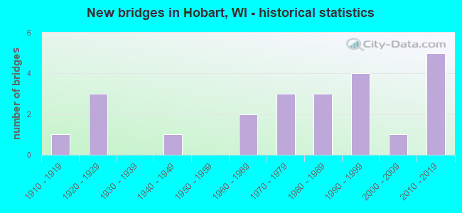
- New bridges - historical statistics
- 11910-1919
- 31920-1929
- 11940-1949
- 21960-1969
- 31970-1979
- 31980-1989
- 41990-1999
- 12000-2009
- 52010-2019
FCC Registered Cell Phone Towers:
1 (See the full list of FCC Registered Cell Phone Towers in Hobart)FCC Registered Antenna Towers:
12 (See the full list of FCC Registered Antenna Towers)FCC Registered Broadcast Land Mobile Towers:
7- 3769 N Overland Rd (Lat: 44.523278 Lon: -88.170194), Type: Bant, Structure height: 4.2 m, Overall height: 6.7 m, Call Sign: WPMK891,
Assigned Frequencies: 453.087 MHz, Grant Date: 06/21/2013, Expiration Date: 08/27/2023, Cancellation Date: 10/28/2023, Certifier: Len Tersinski, Registrant: Village Of Hobart, 2990 S. Pinetree Road, Hobart, WI 54155, Phone: (920) 869-3807, Fax: (920) 869-3808, Email:
- 1149 Airport Road (Lat: 44.492056 Lon: -88.127306), Type: Mast, Structure height: 6.1 m, Overall height: 7.7 m, Call Sign: WQQD522,
Assigned Frequencies: 72.1800 MHz, Grant Date: 10/14/2022, Expiration Date: 11/07/2032, Certifier: Thomas Miller, Registrant: Primex Wireless, Inc., 965 Wells Street, Lake Geneva, WI 53147, Phone: (262) 729-4858, Email:
- ONEIDA, County Road U (1/2 Mile South Of Trout Creek Road) (Lat: 44.530944 Lon: -88.190806), Type: Gtower, Structure height: 57.9 m, Call Sign: WQQJ960,
Assigned Frequencies: 770.556 MHz, 770.806 MHz, 771.156 MHz, 771.556 MHz, 771.856 MHz, 772.106 MHz, 772.356 MHz, 772.631 MHz, Grant Date: 10/20/2022, Expiration Date: 01/10/2033, Certifier: John Lampkin, Registrant: Brown County Public Safety Communications, 3028 Curry Lane, Green Bay, WI 54311, Phone: (920) 391-7404, Fax: (920) 391-7406, Email:
- MAIN, Lat: 44.459056 Lon: -88.145083, Call Sign: WQRL615,
Assigned Frequencies: 469.075 MHz, 466.687 MHz, Grant Date: 04/01/2023, Expiration Date: 06/12/2033, Certifier: Jordan Cappaert, Registrant: Baycom Inc, 2040 Radisson Street, Green Bay, WI 54302, Phone: (920) 544-4248, Email:
- 10001 Fernanado Drive (Lat: 44.459083 Lon: -88.145083), Call Sign: WRDF911,
Assigned Frequencies: 457.137 MHz, Grant Date: 04/19/2019, Expiration Date: 04/19/2029, Certifier: Mark Huberty, Registrant: Baycom Inc, 2040 Radisson Street, Green Bay, WI 54302, Phone: (920) 544-4248, Email:
- 1262 Camber Court (Lat: 44.454444 Lon: -88.130833), Call Sign: WRXB607,
Assigned Frequencies: 452.987 MHz, Grant Date: 04/22/2023, Expiration Date: 04/22/2033, Cancellation Date: 04/27/2023, Certifier: Ryan Nuernberg, Registrant: Nielson Communications, Inc, 645 Mike Mccarthy Way, Green Bay, WI 54304, Phone: (920) 494-1828, Email:
- Lat: 44.543139 Lon: -88.131306, Call Sign: WSAS353,
Assigned Frequencies: 72.2200 MHz, 72.2600 MHz, Grant Date: 02/08/2024, Expiration Date: 02/08/2034, Certifier: Nick Phillips, Registrant: Primex Wireless, Inc., 965 S Wells St., Lake Geneva, WI 53147, Phone: (855) 557-0337, Email:
FCC Registered Microwave Towers:
1- AP-DIEDERICH, No Exact Street Adress (Lat: 44.458417 Lon: -88.168861), Type: Tank, Structure height: 27.1 m, Call Sign: WRQY881,
Assigned Frequencies: 10835.0 MHz, 10835.0 MHz, 10835.0 MHz, 10835.0 MHz, 10835.0 MHz, 10835.0 MHz, 10835.0 MHz, 10835.0 MHz, 10835.0 MHz, 10835.0 MHz, 10835.0 MHz, 10835.0 MHz, Grant Date: 05/23/2022, Expiration Date: 05/23/2032, Certifier: Jonathan D Mlsna, Registrant: Intelpath, Hinsdale, IL 60522, Phone: (312) 841-9188, Email:
FCC Registered Amateur Radio Licenses:
5- Call Sign: KC0ARF, Licensee ID: L00962030, Grant Date: 03/16/2017, Expiration Date: 04/25/2027, Certifier: Christian J Reynolds, Registrant: Christian J Reynolds, 352 Shady Drive, Hobart, WI 54155
- Call Sign: N7XAR, Licensee ID: L00406839, Grant Date: 03/31/2023, Expiration Date: 04/13/2033, Certifier: Steven W Kieffer, Registrant: Steven W Kieffer, 1418 Lear Lane, Hobart, WI 54115
- Call Sign: KC9ESR, Licensee ID: L00742807, Grant Date: 06/18/2013, Expiration Date: 09/15/2023, Certifier: Jeffrey K Last, Registrant: Jeffrey K Last, 4338 Touchstone Drive, Hobart, WI 54155
- Call Sign: WX9GRB, Previous Call Sign: KC9BWF, Licensee ID: L00523645, Grant Date: 02/12/2024, Expiration Date: 12/09/2033, Certifier: Christian J Reynolds, Registrant: Packerland Area Skywarn Society, 352 Shady Dr, Hobart, WI 54155
- Call Sign: KD9BFN, Licensee ID: L01864456, Grant Date: 05/08/2014, Expiration Date: 05/08/2024, Certifier: Glen P Severson, Registrant: Glen P Severson, 362 Crosse Point Ct, Hobart, WI 54155
FAA Registered Aircraft:
2- Aircraft: RENEGADE LIGHT SPORT LLC FALCON LS VS 2.0 (Category: Land, Seats: 2, Weight: Up to 12,499 Pounds), Engine: LYCOMING O235N2C (120 HP) (4 Cycle)
N-Number: 212RL, N212RL, N-212RL, Serial Number: RL 122710-002, Year manufactured: 2011, Airworthiness Date: 04/14/2011, Certificate Issue Date: 10/23/2017
Registrant (Individual): Gary J Brzezinski, 4632 Country Aire Ct, Hobart, WI 54155 - Aircraft: PIPER PA-28-180 (Category: Land, Seats: 4, Weight: Up to 12,499 Pounds, Speed: 107 mph), Engine: LYCOMING O&VO-360 SER (180 HP) (Reciprocating)
N-Number: 8830J, N8830J, N-8830J, Serial Number: 28-2927, Year manufactured: 1965, Airworthiness Date: 12/01/1965, Certificate Issue Date: 09/01/1992
Registrant (Individual): Francis C Burkel, 4315 N Overland Rd, Hobart, WI 54155
2004 - 2018 National Fire Incident Reporting System (NFIRS) incidents
- Fire incident types reported to NFIRS in Hobart, WI
- 5948.0%Structure Fires
- 3629.3%Outside Fires
- 2318.7%Mobile Property/Vehicle Fires
- 54.1%Other
 Based on the data from the years 2004 - 2018 the average number of fires per year is 8. The highest number of fires - 25 took place in 2010, and the least - 0 in 2005. The data has a constant trend.
 When looking into fire subcategories, the most incidents belonged to: Structure Fires (48.0%), and Outside Fires (29.3%).
- 84.4%Utility gas
- 6.6%Electricity
- 5.0%Bottled, tank, or LP gas
- 4.1%Wood
- 47.7%Electricity
- 45.6%Utility gas
- 4.7%Bottled, tank, or LP gas
- 1.8%Other fuel
- 0.1%No fuel used
Hobart compared to Wisconsin state average:
- Unemployed percentage significantly below state average.
- Black race population percentage significantly below state average.
- Renting percentage significantly below state average.
- Length of stay since moving in above state average.
- House age significantly below state average.
- Number of college students above state average.
- Percentage of population with a bachelor's degree or higher above state average.
Hobart on our top lists:
- #11 on the list of "Top 101 cities with largest percentage of males in industries: management of companies and enterprises (population 5,000+)"
- #45 on the list of "Top 101 cities with largest percentage of females in industries: utilities (population 5,000+)"
- #83 on the list of "Top 100 safest cities (lowest city-data.com crime index) (pop. 5,000+)"
- #12 on the list of "Top 101 counties with the lowest percentage of residents relocating to foreign countries in 2011"
- #65 on the list of "Top 101 counties with the highest Sulfur Oxides Annual air pollution readings in 2012 (µg/m3)"
- #83 on the list of "Top 101 counties with the lowest percentage of residents relocating from foreign countries between 2010 and 2011"
- #90 on the list of "Top 101 counties with the largest increase in the number of births per 1000 residents 2000-2006 to 2007-2013 (pop 50,000+)"

|
Total of 46 patent applications in 2008-2024.