Holbrook, Idaho
Submit your own pictures of this place and show them to the world
- OSM Map
- General Map
- Google Map
- MSN Map

| Males: 226 | |
| Females: 179 |
| Median resident age: | 30.3 years |
| Idaho median age: | 33.2 years |
| Holbrook: | $50,008 |
| ID: | $72,785 |
Estimated per capita income in 2022: $21,436 (it was $10,062 in 2000)
Holbrook CCD income, earnings, and wages data
Estimated median house or condo value in 2022: $281,081 (it was $84,200 in 2000)
| Holbrook: | $281,081 |
| ID: | $432,500 |
Mean prices in 2022: all housing units: $324,284; detached houses: $336,520; townhouses or other attached units: $414,084; mobile homes: $134,446
Detailed information about poverty and poor residents in Holbrook, ID
Compare current foreclosures near your location:
| Photo | Address | Area | Beds / Baths | Price | Details |
|---|---|---|---|---|---|

|
#1
Bayberry Cir
Columbus, OH 43207
|
1,564 sq. feet
|
1 baths 3 beds |
$127,500
|
show details |

|
#2
S High St
Columbus, OH 43207
|
1,678 sq. feet
|
2 baths 4 beds |
$31,900
|
show details |

|
#3
E 21st Ave
Columbus, OH 43211
|
1,061 sq. feet
|
1 baths 3 beds |
$179,900
|
show details |

|
#4
S Champion Ave
Columbus, OH 43207
|
1,157 sq. feet
|
1 baths 2 beds |
show details | |

|
#5
Midland Ave
Columbus, OH 43223
|
1,518 sq. feet
|
1 baths 2 beds |
show details | |

|
#6
S Richardson Ave
Columbus, OH 43204
|
1,520 sq. feet
|
2 baths 3 beds |
show details | |

|
#7
Executive Ct
Westerville, OH 43081
|
1,811 sq. feet
|
2 baths 3 beds |
show details | |

|
#8
Stoneybrook Blvd # 21a
Hilliard, OH 43026
|
1,231 sq. feet
|
2 baths 3 beds |
show details | |

|
#9
Striebel Ct
Columbus, OH 43227
|
925 sq. feet
|
1 baths 3 beds |
show details | |

|
#10
Armada Rd
Columbus, OH 43232
|
1,028 sq. feet
|
1 baths 4 beds |
show details |
| Photo | Address | Area | Beds / Baths | Price | Details |
|---|---|---|---|---|---|

|
#11
E Howard Rd
Columbus, OH 43207
|
1,056 sq. feet
|
1 baths 3 beds |
show details | |

|
#12
Fergus Rd
Grove City, OH 43123
|
3,312 sq. feet
|
2 baths 4 beds |
show details | |

|
#13
Marshrun Dr
Grove City, OH 43123
|
2,036 sq. feet
|
2 baths 4 beds |
show details | |

|
#14
Lehner Rd
Columbus, OH 43224
|
1,628 sq. feet
|
2 baths 4 beds |
show details | |

|
#15
Kelton Ave
Columbus, OH 43206
|
1,080 sq. feet
|
1 baths 3 beds |
show details | |

|
#16
Meadowbrook Dr
Columbus, OH 43207
|
1,752 sq. feet
|
2 baths 4 beds |
show details | |

|
#17
E Lincoln Ave
Columbus, OH 43214
|
874 sq. feet
|
1 baths 3 beds |
show details | |

|
#18
Elaine Rd
Columbus, OH 43213
|
764 sq. feet
|
1 baths 2 beds |
show details | |

|
#19
Falls Peak Ln
Delaware, OH 43015
|
1,352 sq. feet
|
2 baths 2 beds |
show details | |

|
#20
Wrexham Ave
Columbus, OH 43223
|
1,235 sq. feet
|
1 baths 3 beds |
show details |
| Photo | Address | Area | Beds / Baths | Price | Details |
|---|---|---|---|---|---|

|
#21
Grasmere Ave
Columbus, OH 43211
|
720 sq. feet
|
1 baths 2 beds |
show details | |

|
#22
Hamilton Ave
Columbus, OH 43211
|
1,061 sq. feet
|
1 baths 3 beds |
show details | |

|
#23
S Hague Ave
Columbus, OH 43204
|
979 sq. feet
|
1 baths 2 beds |
show details | |

|
#24
Chidley St
Galloway, OH 43119
|
1,502 sq. feet
|
1 baths 3 beds |
show details | |

|
#25
E Welch Ave
Columbus, OH 43207
|
1,864 sq. feet
|
2 baths 4 beds |
show details | |

|
#26
Kingsglen Dr
Grove City, OH 43123
|
1,635 sq. feet
|
2 baths 4 beds |
show details | |

|
#27
Brookstone Dr
Westerville, OH 43082
|
1,783 sq. feet
|
3 baths 3 beds |
show details | |

|
#28
London Groveport Rd
Grove City, OH 43123
|
816 sq. feet
|
1 baths 2 beds |
show details | |

|
#29
Upton Rd E
Columbus, OH 43232
|
852 sq. feet
|
1 baths 3 beds |
show details | |

|
#30
Fairfield Ave
Columbus, OH 43203
|
984 sq. feet
|
1 baths 2 beds |
show details |
| Photo | Address | Area | Beds / Baths | Price | Details |
|---|---|---|---|---|---|

|
#31
N 18th St
Columbus, OH 43203
|
1,690 sq. feet
|
1 baths 4 beds |
show details | |

|
#32
High Free Pike
West Jefferson, OH 43162
|
1,216 sq. feet
|
2 baths 4 beds |
show details | |

|
#33
Ashgrove Dr
Grove City, OH 43123
|
1,772 sq. feet
|
2 baths 4 beds |
show details | |

|
#34
Whittman Ct
Plain City, OH 43064
|
3,186 sq. feet
|
3 baths 4 beds |
show details | |

|
#35
Hildreth Ave
Columbus, OH 43203
|
1,798 sq. feet
|
2 baths 4 beds |
show details | |

|
#36
Glenmate Ct
Columbus, OH 43223
|
1,050 sq. feet
|
1 baths 3 beds |
show details | |

|
#37
Gladys Rd
Columbus, OH 43228
|
832 sq. feet
|
1 baths 3 beds |
show details | |

|
#38
Chester Rd
Columbus, OH 43221
|
3,300 sq. feet
|
4 baths 5 beds |
show details | |

|
#39
Summertree Ln
Westerville, OH 43081
|
2,496 sq. feet
|
2 baths 3 beds |
show details | |

|
#40
Scottwood Rd
Columbus, OH 43227
|
1,008 sq. feet
|
1 baths 3 beds |
show details |
| Photo | Address | Area | Beds / Baths | Price | Details |
|---|---|---|---|---|---|

|
#41
Maroon Dr
Powell, OH 43065
|
1,198 sq. feet
|
2 baths 3 beds |
show details | |

|
#42
Ridgebury Dr
Hilliard, OH 43026
|
832 sq. feet
|
1 baths 2 beds |
show details | |

|
#43
Lynn Cir
Grove City, OH 43123
|
936 sq. feet
|
1 baths 3 beds |
show details | |

|
#44
Conway Dr
Columbus, OH 43227
|
1,232 sq. feet
|
1 baths 3 beds |
show details | |

|
#45
Leap Rd
Hilliard, OH 43026
|
1,352 sq. feet
|
1 baths 3 beds |
show details | |

|
#46
E Kanawha Ave
Columbus, OH 43214
|
1,230 sq. feet
|
1 baths 3 beds |
show details | |

|
#47
Dunrovin Dr
New Albany, OH 43054
|
2,899 sq. feet
|
2 baths 4 beds |
show details | |

|
#48
Nantucket Ave
Columbus, OH 43235
|
1,864 sq. feet
|
2 baths 3 beds |
show details | |

|
#49
Mango Ln
Hilliard, OH 43026
|
1,024 sq. feet
|
1 baths 2 beds |
show details | |

|
Check over 1 million property listings on Foreclosure.com!
|
browse all offers | |||

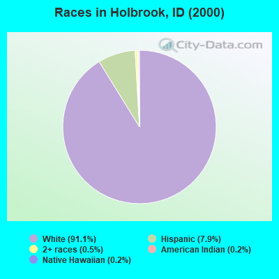
- 37091.1%White alone
- 327.9%Hispanic
- 20.5%Two or more races
- 10.2%American Indian alone
- 10.2%Native Hawaiian and Other
Pacific Islander alone
Races in Holbrook detailed stats: ancestries, foreign born residents, place of birth
According to our research of Idaho and other state lists, there was 1 registered sex offender living in Holbrook, Idaho as of May 16, 2024.
The ratio of all residents to sex offenders in Holbrook is 405 to 1.
The ratio of registered sex offenders to all residents in this city is lower than the state average.
 Recent articles from our blog. Our writers, many of them Ph.D. graduates or candidates, create easy-to-read articles on a wide variety of topics.
Current Local Time: MST time zone
Elevation: 4779 feet
Land area: 669.4 square miles.
Population density: 0.6 people per square mile (very low).

| Holbrook CCD: | 0.7% ($577) |
| Idaho: | 1.0% ($1,007) |
Nearest city with pop. 50,000+: Pocatello, ID  (53.2 miles , pop. 51,466).
Nearest city with pop. 200,000+: Northeast Jefferson, CO (430.2 miles , pop. 450,166).
Nearest city with pop. 1,000,000+: Phoenix, AZ (596.1 miles , pop. 1,321,045).
Nearest cities:
), ), ), ), Latitude: 42.13 N, Longitude: 112.72 W
Area code: 208

| Here: | 3.3% |
| Idaho: | 3.1% |

- Agriculture, forestry, fishing & hunting (30.7%)
- Educational services (13.5%)
- Truck transportation (8.3%)
- Gasoline stations (7.8%)
- Construction (5.7%)
- Food & beverage stores (5.7%)
- Printing & related support activities (3.6%)
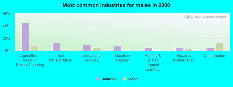
- Agriculture, forestry, fishing & hunting (44.6%)
- Truck transportation (13.2%)
- Educational services (9.1%)
- Gasoline stations (7.4%)
- Printing & related support activities (5.8%)
- Repair & maintenance (5.8%)
- Construction (5.0%)
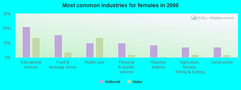
- Educational services (21.1%)
- Food & beverage stores (15.5%)
- Health care (9.9%)
- Personal & laundry services (9.9%)
- Gasoline stations (8.5%)
- Agriculture, forestry, fishing & hunting (7.0%)
- Construction (7.0%)
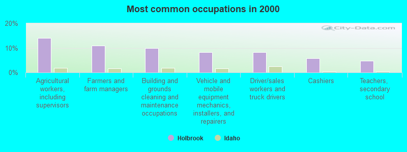
- Agricultural workers, including supervisors (14.1%)
- Farmers and farm managers (10.9%)
- Building and grounds cleaning and maintenance occupations (9.9%)
- Vehicle and mobile equipment mechanics, installers, and repairers (8.3%)
- Driver/sales workers and truck drivers (8.3%)
- Cashiers (5.7%)
- Teachers, secondary school (4.7%)
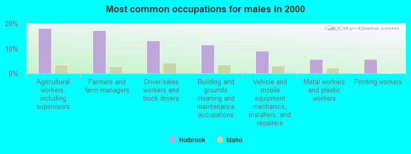
- Agricultural workers, including supervisors (18.2%)
- Farmers and farm managers (17.4%)
- Driver/sales workers and truck drivers (13.2%)
- Building and grounds cleaning and maintenance occupations (11.6%)
- Vehicle and mobile equipment mechanics, installers, and repairers (9.1%)
- Metal workers and plastic workers (5.8%)
- Printing workers (5.8%)
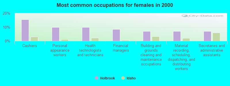
- Cashiers (15.5%)
- Personal appearance workers (9.9%)
- Health technologists and technicians (9.9%)
- Financial managers (8.5%)
- Building and grounds cleaning and maintenance occupations (7.0%)
- Material recording, scheduling, dispatching, and distributing workers (7.0%)
- Secretaries and administrative assistants (7.0%)
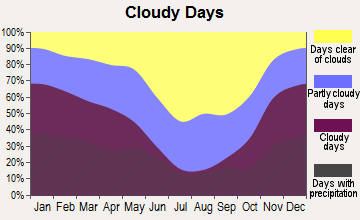
Average climate in Holbrook, Idaho
Based on data reported by over 4,000 weather stations


Earthquake activity:
Holbrook-area historical earthquake activity is significantly above Idaho state average. It is 2074% greater than the overall U.S. average.On 8/18/1959 at 06:37:13, a magnitude 7.7 (7.7 UK, Class: Major, Intensity: VIII - XII) earthquake occurred 197.7 miles away from the city center, causing $26,000,000 total damage
On 10/28/1983 at 14:06:06, a magnitude 7.3 (6.2 MB, 7.3 MS, 7.0 MW) earthquake occurred 145.3 miles away from the city center, causing 2 deaths (2 shaking deaths) and 3 injuries, causing $15,000,000 total damage
On 10/3/1915 at 06:52:48, a magnitude 7.6 (7.6 UK) earthquake occurred 272.9 miles away from Holbrook center
On 3/28/1975 at 02:31:05, a magnitude 6.2 (6.1 MB, 6.0 MS, 6.2 ML, Class: Strong, Intensity: VII - IX) earthquake occurred 14.9 miles away from the city center
On 3/31/2020 at 23:52:30, a magnitude 6.5 (6.5 MW, Depth: 7.5 mi) earthquake occurred 201.6 miles away from Holbrook center
On 12/21/1932 at 06:10:09, a magnitude 7.2 (7.2 UK) earthquake occurred 377.9 miles away from Holbrook center
Magnitude types: body-wave magnitude (MB), local magnitude (ML), surface-wave magnitude (MS), moment magnitude (MW)
Natural disasters:
The number of natural disasters in Oneida County (2) is a lot smaller than the US average (15).Emergencies Declared: 1
Causes of natural disasters: Hurricane: 1, Other: 1 (Note: some incidents may be assigned to more than one category).
Colleges/universities with over 2000 students nearest to Holbrook:
- Idaho State University (about 53 miles; Pocatello, ID; Full-time enrollment: 10,350)
- Utah State University (about 54 miles; Logan, UT; FT enrollment: 21,131)
- Weber State University (about 77 miles; Ogden, UT; FT enrollment: 17,655)
- College of Southern Idaho (about 96 miles; Twin Falls, ID; FT enrollment: 5,051)
- Latter-day Saints Business College (about 104 miles; Salt Lake City, UT; FT enrollment: 2,059)
- University of Utah (about 105 miles; Salt Lake City, UT; FT enrollment: 28,454)
- Westminster College (about 107 miles; Salt Lake City, UT; FT enrollment: 2,870)
Points of interest:
Notable locations in Holbrook: Salyer Cow Camp (A), Hansen Ranch (B), Curlew Campground (C), Grandine Ranger Station (D). Display/hide their locations on the map
Cemetery: Holbrook Cemetery (1). Display/hide its location on the map
Reservoirs: Pine Creek Reservoir (A), Sweeten Reservoir (B), Curlew Valley Reservoir (C), Stone Reservoir (D). Display/hide their locations on the map
Creeks: Pine Creek (A), Sheep Creek (B), Meadow Brook Creek (C). Display/hide their locations on the map
Park in Holbrook: Hudspeth Cutoff Historical Marker (1). Display/hide its location on the map
| This place: | 2.8 people |
| Idaho: | 2.7 people |
| This place: | 82.7% |
| Whole state: | 69.6% |
| This place: | 3.1% |
| Whole state: | 6.3% |
Likely homosexual households (counted as self-reported same-sex unmarried-partner households)
- Lesbian couples: 0.0% of all households
- Gay men: 0.8% of all households
| This place: | 20.8% |
| Whole state: | 11.8% |
| This place: | 1.3% |
| Whole state: | 4.6% |
For population 15 years and over in Holbrook:
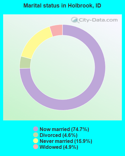
- Never married: 15.9%
- Now married: 74.7%
- Separated: 0.0%
- Widowed: 4.9%
- Divorced: 4.6%
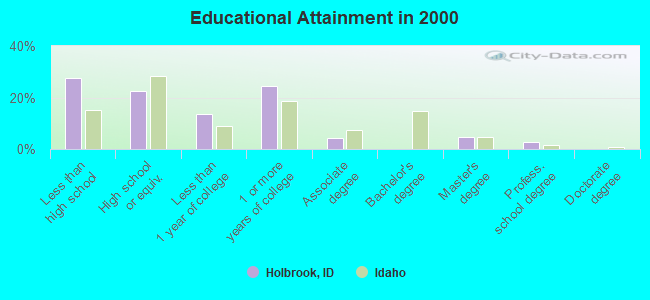
For population 25 years and over in Holbrook:
- High school or higher: 72.3%
- Bachelor's degree or higher: 7.3%
- Graduate or professional degree: 7.3%
- Unemployed: 6.8%
- Mean travel time to work (commute): 31.5 minutes
| Here: | 12.0 |
| Idaho average: | 11.1 |

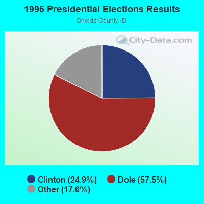


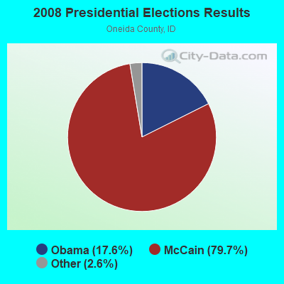
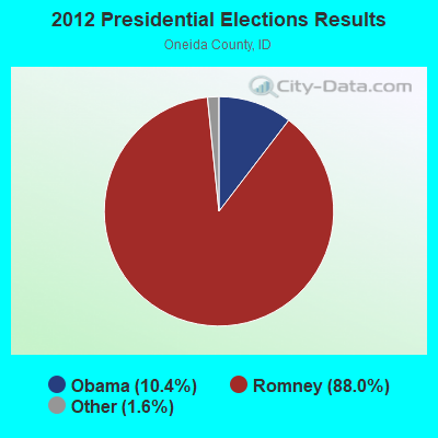
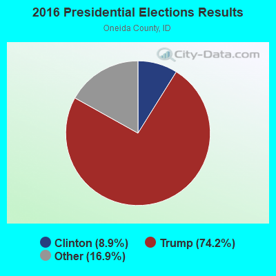
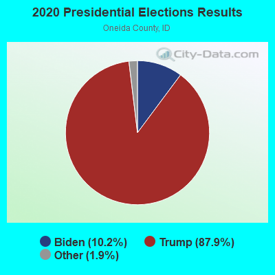
Graphs represent county-level data. Detailed 2008 Election Results
Religion statistics for Holbrook, ID (based on Oneida County data)
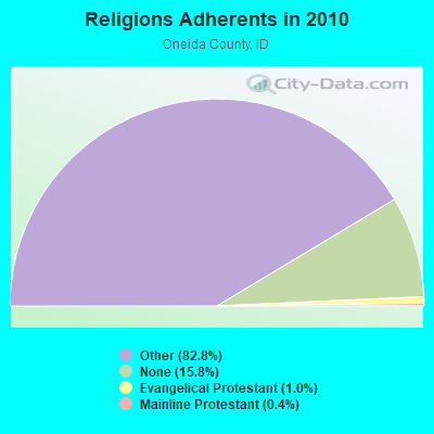

| Religion | Adherents | Congregations |
|---|---|---|
| Other | 3,547 | 10 |
| Evangelical Protestant | 45 | 1 |
| Mainline Protestant | 17 | 1 |
| Catholic | - | - |
| None | 677 | - |
Food Environment Statistics:
| Oneida County: | 2.44 / 10,000 pop. |
| State: | 1.88 / 10,000 pop. |
| This county: | 7.33 / 10,000 pop. |
| State: | 3.87 / 10,000 pop. |
| This county: | 7.33 / 10,000 pop. |
| Idaho: | 7.75 / 10,000 pop. |
| This county: | 8.8% |
| Idaho: | 7.7% |
| Here: | 25.3% |
| State: | 25.7% |
| This county: | 2.1% |
| Idaho: | 11.7% |
Strongest AM radio stations in Holbrook:
- KALL (700 AM; 50 kW; NORTH SALT LAKE CITY, UT; Owner: CITICASTERS LICENSES, L.P.)
- KIQN (1010 AM; 50 kW; TOOELE, UT)
- KSL (1160 AM; 50 kW; SALT LAKE CITY, UT; Owner: BONNEVILLE HOLDING COMPANY)
- KSOS (800 AM; 10 kW; BRIGHAM CITY, UT; Owner: SIMMONS-SLC, LS, LLC)
- KVNU (610 AM; 5 kW; LOGAN, UT; Owner: SUN VALLEY RADIO,INC.)
- KZNR (690 AM; 10 kW; BLACKFOOT, ID; Owner: WESTERN COMMUNICATIONS, INC.)
- KBOI (670 AM; 50 kW; BOISE, ID; Owner: CITADEL BROADCASTING COMPANY)
- KSEI (930 AM; 5 kW; POCATELLO, ID; Owner: PACIFIC EMPIRE COMMUNICATIONS CORP.)
- KXOL (1660 AM; 10 kW; BRIGHAM CITY, UT; Owner: SIMMONS-SLC, LS, LLC)
- KBRV (790 AM; 5 kW; SODA SPRINGS, ID; Owner: CARIBOU BROADCASTING INC.)
- KANN (1120 AM; 10 kW; ROY, UT; Owner: FAITH COMMUNICATIONS CORPORATION)
- KLGN (1390 AM; 5 kW; LOGAN, UT; Owner: SUN VALLEY RADIO, INC.)
- KTKK (630 AM; 10 kW; SANDY, UT; Owner: UNITED BROADCASTING COMPANY)
Strongest FM radio stations in Holbrook:
- KRAR (106.9 FM; BRIGHAM CITY, UT; Owner: MERCURY BROADCASTING COMPANY, INC.)
- KJQN (100.7 FM; BRIGHAM CITY, UT; Owner: SIMMONS-SLC, LS, LLC)
- KBSY (88.5 FM; BURLEY, ID; Owner: IDAHO STATE BOARD OF EDUCATION)
- KCIR (90.7 FM; TWIN FALLS, ID; Owner: FAITH COMMUNICATIONS CORP)
- KKMV (92.5 FM; RUPERT, ID; Owner: TRI-MARKET RADIO BROADCASTERS, INC.)
- KZDX (99.9 FM; BURLEY, ID; Owner: KART & EAGLE ROCK B/C INC,TENANTS)
- K299AH (107.7 FM; POCATELLO, ID; Owner: UNIVERSITY OF UTAH)
- KBNZ (104.9 FM; TREMONTON, UT; Owner: 3 POINT MEDIA - UTAH, LLC)
- KUDD (107.9 FM; ROY, UT; Owner: MILLCREEK BROADCASTING, L.L.C.)
- K220HI (91.9 FM; CLARKSTON, UT; Owner: CALVARY CHAPEL OF TWIN FALLS, INC.)
- KUSU-FM (91.5 FM; LOGAN, UT; Owner: UTAH STATE UNIV. OF AGRI. & APP. SCI)
- KYFO-FM (95.5 FM; OGDEN, UT; Owner: BIBLE BROADCASTING NETWORK, INC.)
- KVFX (94.5 FM; LOGAN, UT; Owner: SUN VALLEY RADIO,INC.)
- KISU-FM (91.1 FM; POCATELLO, ID; Owner: IDAHO STATE UNIVERSITY)
- KORR (104.1 FM; AMERICAN FALLS, ID; Owner: IDAHO WIRELESS CORPORATION)
TV broadcast stations around Holbrook:
- K59BV (Channel 59; LAVA HOT SPRINGS, ID; Owner: STATE BOARD OF EDUCATION (IEPBS))
Holbrook fatal accident list:
Dec 8, 2012 08:16 AM, I-84, Lat: 42.065225, Lon: -112.900014, Vehicles: 1, Persons: 6, Fatalities: 1
FCC Registered Antenna Towers:
15 (See the full list of FCC Registered Antenna Towers in Holbrook)FCC Registered Broadcast Land Mobile Towers:
1- Hwy Don Eliason Ranch 3 Mi N (Lat: 42.148250 Lon: -112.738583), Call Sign: KNCJ715,
Assigned Frequencies: 154.625 MHz, Grant Date: 03/25/2002, Expiration Date: 02/17/2012, Cancellation Date: 04/21/2012, Registrant: Federal Licensing Inc, 1588 Fairfield Rd, Gettysburg, PA 17325, Phone: (717) 334-9262, Fax: (717) 334-6440
FCC Registered Microwave Towers:
2- Nalder site, 6.4 Km North Of Holbrook (Lat: 42.207528 Lon: -112.693583), Type: Ltower, Structure height: 4.3 m, Call Sign: WQKN578,
Assigned Frequencies: 470.000 MHz, Grant Date: 07/24/2009, Expiration Date: 10/01/2030, Certifier: Norman Jaussi, Registrant: Oneida County Translatora District, 10 Court Street, Malad City, ID 83252, Phone: (208) 315-0513
- HOLBROOK ETC, Holbrook Road And 2100 East (Lat: 42.167917 Lon: -112.660639), Type: Ltower, Structure height: 76.2 m, Overall height: 78 m, Call Sign: WQZX632,
Assigned Frequencies: 5945.20 MHz, 6004.50 MHz, 6063.80 MHz, 6093.45 MHz, Grant Date: 08/30/2017, Expiration Date: 08/30/2027, Certifier: Dave Cundiff, Registrant: At&t Services, Inc., 208 S Akard St, 20f, Dallas, TX 75202, Phone: (855) 699-7073, Email:
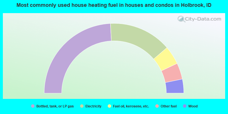
- 48.4%Bottled, tank, or LP gas
- 29.0%Electricity
- 8.6%Fuel oil, kerosene, etc.
- 7.5%Other fuel
- 6.5%Wood
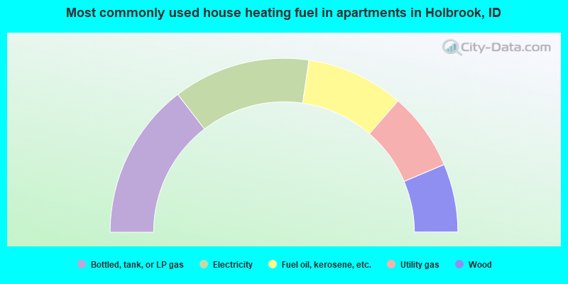
- 29.1%Bottled, tank, or LP gas
- 25.5%Electricity
- 18.2%Fuel oil, kerosene, etc.
- 14.5%Utility gas
- 12.7%Wood
Holbrook compared to Idaho state average:
- Median house value below state average.
- Unemployed percentage below state average.
- Black race population percentage significantly below state average.
- Hispanic race population percentage below state average.
- Median age significantly below state average.
- Foreign-born population percentage significantly below state average.
- Length of stay since moving in significantly above state average.
- Number of rooms per house significantly below state average.
- House age significantly below state average.
- Number of college students significantly below state average.
- Percentage of population with a bachelor's degree or higher significantly below state average.