Howe, Idaho

Submit your own pictures of this place and show them to the world
- OSM Map
- General Map
- Google Map
- MSN Map

| Males: 168 | |
| Females: 160 |
| Median resident age: | 34.3 years |
| Idaho median age: | 33.2 years |
| Howe: | $37,392 |
| ID: | $72,785 |
Estimated per capita income in 2022: $22,135 (it was $11,899 in 2000)
Howe CCD income, earnings, and wages data
Estimated median house or condo value in 2022: $306,129 (it was $83,300 in 2000)
| Howe: | $306,129 |
| ID: | $432,500 |
Mean prices in 2022: all housing units: $383,314; detached houses: $413,310; mobile homes: $157,209
Detailed information about poverty and poor residents in Howe, ID
Compare current foreclosures near your location:
| Photo | Address | Area | Beds / Baths | Price | Details |
|---|---|---|---|---|---|

|
#1
Bayberry Cir
Columbus, OH 43207
|
1,564 sq. feet
|
1 baths 3 beds |
$127,500
|
show details |

|
#2
S High St
Columbus, OH 43207
|
1,678 sq. feet
|
2 baths 4 beds |
$31,900
|
show details |

|
#3
E 21st Ave
Columbus, OH 43211
|
1,061 sq. feet
|
1 baths 3 beds |
$179,900
|
show details |

|
#4
S Hague Ave
Columbus, OH 43204
|
979 sq. feet
|
1 baths 2 beds |
show details | |

|
#5
Hiawatha Park Dr
Columbus, OH 43211
|
1,278 sq. feet
|
1 baths 4 beds |
show details | |

|
#6
Hamilton Ave
Columbus, OH 43211
|
1,061 sq. feet
|
1 baths 3 beds |
show details | |

|
#7
Grasmere Ave
Columbus, OH 43211
|
720 sq. feet
|
1 baths 2 beds |
show details | |

|
#8
Striebel Ct
Columbus, OH 43227
|
925 sq. feet
|
1 baths 3 beds |
show details | |

|
#9
Kelton Ave
Columbus, OH 43206
|
1,080 sq. feet
|
1 baths 3 beds |
show details | |

|
#10
Summertree Ln
Westerville, OH 43081
|
2,496 sq. feet
|
2 baths 3 beds |
show details |
| Photo | Address | Area | Beds / Baths | Price | Details |
|---|---|---|---|---|---|

|
#11
E Welch Ave
Columbus, OH 43207
|
1,864 sq. feet
|
2 baths 4 beds |
show details | |

|
#12
Fergus Rd
Grove City, OH 43123
|
3,312 sq. feet
|
2 baths 4 beds |
show details | |

|
#13
Upton Rd E
Columbus, OH 43232
|
852 sq. feet
|
1 baths 3 beds |
show details | |

|
#14
Chester Rd
Columbus, OH 43221
|
3,300 sq. feet
|
4 baths 5 beds |
show details | |

|
#15
Executive Ct
Westerville, OH 43081
|
1,811 sq. feet
|
2 baths 3 beds |
show details | |

|
#16
E Howard Rd
Columbus, OH 43207
|
1,056 sq. feet
|
1 baths 3 beds |
show details | |

|
#17
Cannonade Ct
Columbus, OH 43230
|
2,023 sq. feet
|
2 baths 3 beds |
show details | |

|
#18
Fairfield Ave
Columbus, OH 43203
|
984 sq. feet
|
1 baths 2 beds |
show details | |

|
#19
E Lincoln Ave
Columbus, OH 43214
|
874 sq. feet
|
1 baths 3 beds |
show details | |

|
#20
S Champion Ave
Columbus, OH 43207
|
1,157 sq. feet
|
1 baths 2 beds |
show details |
| Photo | Address | Area | Beds / Baths | Price | Details |
|---|---|---|---|---|---|

|
#21
Wrexham Ave
Columbus, OH 43223
|
1,235 sq. feet
|
1 baths 3 beds |
show details | |

|
#22
Armada Rd
Columbus, OH 43232
|
1,028 sq. feet
|
1 baths 4 beds |
show details | |

|
#23
Falls Peak Ln
Delaware, OH 43015
|
1,352 sq. feet
|
2 baths 2 beds |
show details | |

|
#24
N Roys Ave
Columbus, OH 43204
|
1,248 sq. feet
|
2 baths 3 beds |
show details | |

|
#25
Meadowbrook Dr
Columbus, OH 43207
|
1,752 sq. feet
|
2 baths 4 beds |
show details | |

|
#26
Glenmate Ct
Columbus, OH 43223
|
1,050 sq. feet
|
1 baths 3 beds |
show details | |

|
#27
High Free Pike
West Jefferson, OH 43162
|
1,216 sq. feet
|
2 baths 4 beds |
show details | |

|
#28
Stoneybrook Blvd # 21a
Hilliard, OH 43026
|
1,231 sq. feet
|
2 baths 3 beds |
show details | |

|
#29
Chidley St
Galloway, OH 43119
|
1,502 sq. feet
|
1 baths 3 beds |
show details | |

|
#30
London Groveport Rd
Grove City, OH 43123
|
816 sq. feet
|
1 baths 2 beds |
show details |
| Photo | Address | Area | Beds / Baths | Price | Details |
|---|---|---|---|---|---|

|
#31
Kingsglen Dr
Grove City, OH 43123
|
1,635 sq. feet
|
2 baths 4 beds |
show details | |

|
#32
S Richardson Ave
Columbus, OH 43204
|
1,520 sq. feet
|
2 baths 3 beds |
show details | |

|
#33
Whittman Ct
Plain City, OH 43064
|
3,186 sq. feet
|
3 baths 4 beds |
show details | |

|
#34
N 18th St
Columbus, OH 43203
|
1,690 sq. feet
|
1 baths 4 beds |
show details | |

|
#35
Marshrun Dr
Grove City, OH 43123
|
2,036 sq. feet
|
2 baths 4 beds |
show details | |

|
#36
Gladys Rd
Columbus, OH 43228
|
832 sq. feet
|
1 baths 3 beds |
show details | |

|
#37
Ashgrove Dr
Grove City, OH 43123
|
1,772 sq. feet
|
2 baths 4 beds |
show details | |

|
#38
Elaine Rd
Columbus, OH 43213
|
764 sq. feet
|
1 baths 2 beds |
show details | |

|
#39
Midland Ave
Columbus, OH 43223
|
1,518 sq. feet
|
1 baths 2 beds |
show details | |

|
#40
Brookstone Dr
Westerville, OH 43082
|
1,783 sq. feet
|
3 baths 3 beds |
show details |
| Photo | Address | Area | Beds / Baths | Price | Details |
|---|---|---|---|---|---|

|
#41
Scottwood Rd
Columbus, OH 43227
|
1,008 sq. feet
|
1 baths 3 beds |
show details | |

|
#42
Hildreth Ave
Columbus, OH 43203
|
1,798 sq. feet
|
2 baths 4 beds |
show details | |

|
#43
Lehner Rd
Columbus, OH 43224
|
1,628 sq. feet
|
2 baths 4 beds |
show details | |

|
#44
Morality Dr
Columbus, OH 43231
|
1,903 sq. feet
|
2 baths 4 beds |
show details | |

|
#45
Belfast Dr
Columbus, OH 43227
|
1,142 sq. feet
|
2 baths 3 beds |
show details | |

|
#46
Doral Ave
Columbus, OH 43213
|
2,008 sq. feet
|
2 baths 4 beds |
show details | |

|
#47
S Cypress Ave
Columbus, OH 43222
|
1,508 sq. feet
|
1 baths 3 beds |
show details | |

|
#48
Bucknell Rd
Columbus, OH 43213
|
1,054 sq. feet
|
1 baths 3 beds |
show details | |

|
#49
Pegwood Dr
Columbus, OH 43229
|
878 sq. feet
|
1 baths 1 beds |
show details | |

|
Check over 1 million property listings on Foreclosure.com!
|
browse all offers | |||

- 32093.3%White alone
- 175.0%Hispanic
- 30.9%Two or more races
- 20.6%American Indian alone
- 10.3%Asian alone
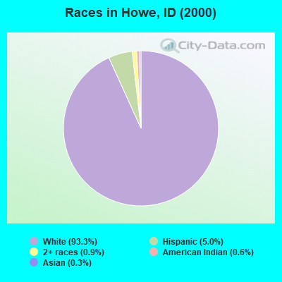
Races in Howe detailed stats: ancestries, foreign born residents, place of birth
 Recent articles from our blog. Our writers, many of them Ph.D. graduates or candidates, create easy-to-read articles on a wide variety of topics.
Current Local Time: MST time zone
Elevation: 4824 feet
Land area: 1166.1 square miles.
Population density: 0.3 people per square mile (very low).
| Howe CCD: | 0.7% ($586) |
| Idaho: | 1.0% ($1,007) |
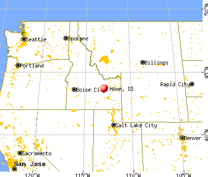
Nearest city with pop. 50,000+: Idaho Falls, ID  (47.5 miles , pop. 50,730).
Nearest city with pop. 200,000+: West Adams, CO (487.3 miles , pop. 259,628).
Nearest city with pop. 1,000,000+: Phoenix, AZ (704.5 miles , pop. 1,321,045).
Nearest cities:
)Latitude: 43.69 N, Longitude: 112.94 W
Area code commonly used in this area: 208

| Here: | 2.7% |
| Idaho: | 3.1% |
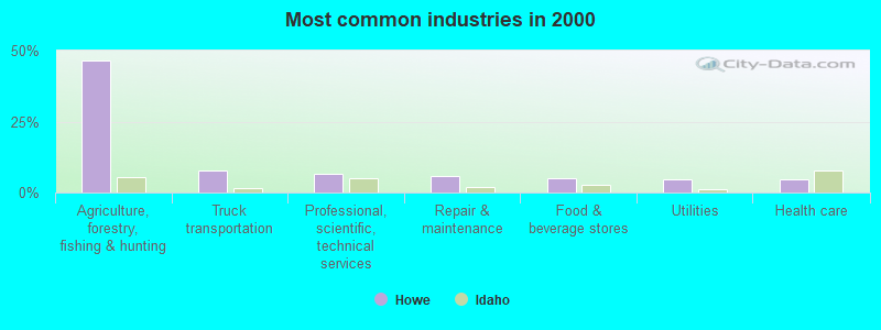
- Agriculture, forestry, fishing & hunting (46.3%)
- Truck transportation (7.9%)
- Professional, scientific, technical services (6.8%)
- Repair & maintenance (5.6%)
- Food & beverage stores (5.1%)
- Utilities (4.5%)
- Health care (4.5%)
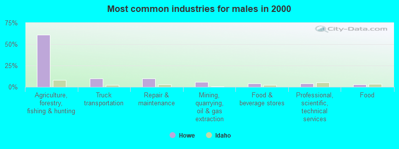
- Agriculture, forestry, fishing & hunting (61.2%)
- Truck transportation (9.7%)
- Repair & maintenance (9.7%)
- Mining, quarrying, oil & gas extraction (5.8%)
- Food & beverage stores (3.9%)
- Professional, scientific, technical services (3.9%)
- Food (2.9%)
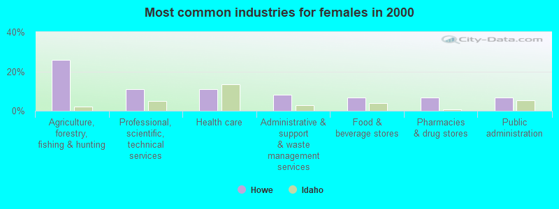
- Agriculture, forestry, fishing & hunting (25.7%)
- Professional, scientific, technical services (10.8%)
- Health care (10.8%)
- Administrative & support & waste management services (8.1%)
- Food & beverage stores (6.8%)
- Pharmacies & drug stores (6.8%)
- Public administration (6.8%)
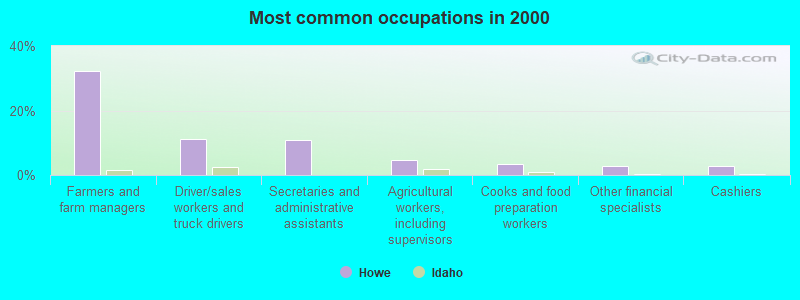
- Farmers and farm managers (32.2%)
- Driver/sales workers and truck drivers (11.3%)
- Secretaries and administrative assistants (10.7%)
- Agricultural workers, including supervisors (4.5%)
- Cooks and food preparation workers (3.4%)
- Other financial specialists (2.8%)
- Cashiers (2.8%)
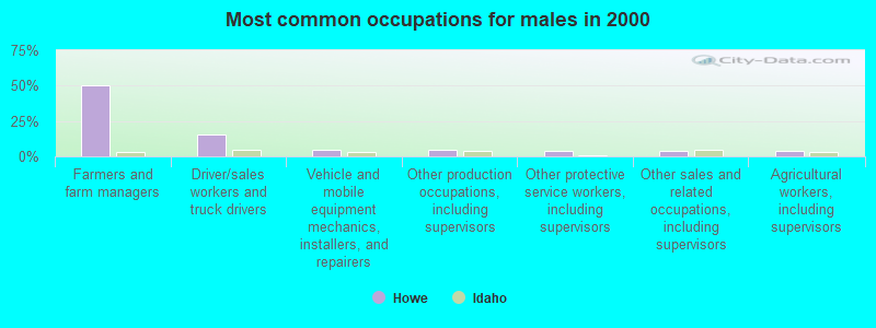
- Farmers and farm managers (50.5%)
- Driver/sales workers and truck drivers (15.5%)
- Vehicle and mobile equipment mechanics, installers, and repairers (4.9%)
- Other production occupations, including supervisors (4.9%)
- Other protective service workers, including supervisors (3.9%)
- Other sales and related occupations, including supervisors (3.9%)
- Agricultural workers, including supervisors (3.9%)
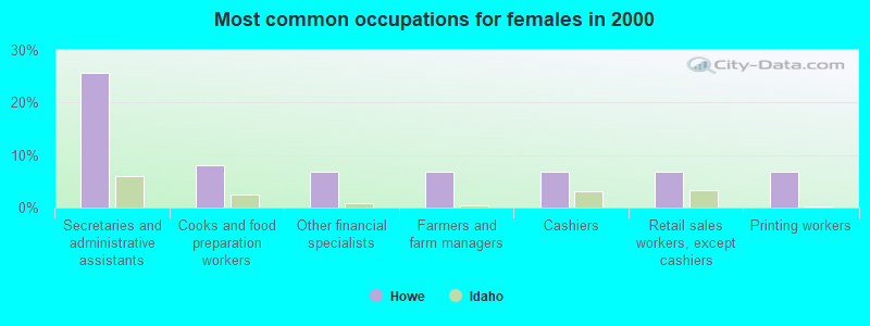
- Secretaries and administrative assistants (25.7%)
- Cooks and food preparation workers (8.1%)
- Other financial specialists (6.8%)
- Farmers and farm managers (6.8%)
- Cashiers (6.8%)
- Retail sales workers, except cashiers (6.8%)
- Printing workers (6.8%)
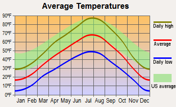
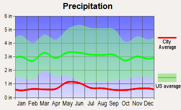
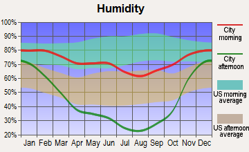
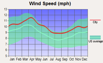
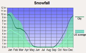
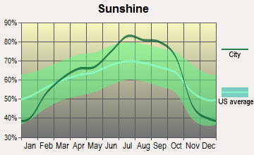
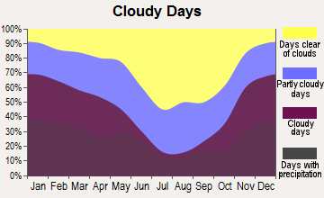
Average climate in Howe, Idaho
Based on data reported by over 4,000 weather stations
Earthquake activity:
Howe-area historical earthquake activity is significantly above Idaho state average. It is 1799% greater than the overall U.S. average.On 8/18/1959 at 06:37:13, a magnitude 7.7 (7.7 UK, Class: Major, Intensity: VIII - XII) earthquake occurred 128.6 miles away from the city center, causing $26,000,000 total damage
On 10/28/1983 at 14:06:06, a magnitude 7.3 (6.2 MB, 7.3 MS, 7.0 MW) earthquake occurred 50.6 miles away from Howe center, causing 2 deaths (2 shaking deaths) and 3 injuries, causing $15,000,000 total damage
On 10/3/1915 at 06:52:48, a magnitude 7.6 (7.6 UK) earthquake occurred 321.6 miles away from Howe center
On 3/31/2020 at 23:52:30, a magnitude 6.5 (6.5 MW, Depth: 7.5 mi, Class: Strong, Intensity: VII - IX) earthquake occurred 120.7 miles away from the city center
On 3/28/1975 at 02:31:05, a magnitude 6.2 (6.1 MB, 6.0 MS, 6.2 ML) earthquake occurred 118.5 miles away from the city center
On 10/28/1983 at 19:51:24, a magnitude 5.8 (5.4 MB, 5.1 MS, 5.8 ML, Class: Moderate, Intensity: VI - VII) earthquake occurred 49.6 miles away from the city center
Magnitude types: body-wave magnitude (MB), local magnitude (ML), surface-wave magnitude (MS), moment magnitude (MW)
Natural disasters:
The number of natural disasters in Butte County (5) is a lot smaller than the US average (15).Major Disasters (Presidential) Declared: 3
Emergencies Declared: 1
Causes of natural disasters: Floods: 2, Earthquake: 1, Heavy Rain: 1, Hurricane: 1, Other: 1 (Note: some incidents may be assigned to more than one category).
Airports located in Howe:
- Howe Airport (U97) (Runways: 1, Itinerant Ops: 4,000, Local Ops: 500)
Colleges/universities with over 2000 students nearest to Howe:
- Brigham Young University-Idaho (about 59 miles; Rexburg, ID; Full-time enrollment: 30,522)
- Idaho State University (about 63 miles; Pocatello, ID; FT enrollment: 10,350)
- College of Southern Idaho (about 110 miles; Twin Falls, ID; FT enrollment: 5,051)
- Utah State University (about 147 miles; Logan, UT; FT enrollment: 21,131)
- Boise State University (about 164 miles; Boise, ID; FT enrollment: 16,774)
- Montana State University (about 166 miles; Bozeman, MT; FT enrollment: 12,942)
- College of Western Idaho (about 179 miles; Nampa, ID; FT enrollment: 6,300)
Public elementary/middle school in Howe:
- HOWE ELEMENTARY SCHOOL (Students: 30, Location: 3512 LITTLE LOST RIVER HWY, Grades: PK-5)
Points of interest:
Notable locations in Howe: Bell Mountain Ranger Station (A), Little Lost River Access Area (B), Fallert (C), Little Lost Ski Area (D), Idaho National Laboratory Safety Department Station 3 (E), Idaho National Laboratory Safety Department Station 1 (F). Display/hide their locations on the map
Lake: Pass Creek Lake (A). Display/hide its location on the map
Streams, rivers, and creeks: Cedar Run Creek (A), Camp Creek (B), Cabin Fork (C), Boulder Creek (D), Black Creek (E), Birch Creek (F), Big Spring Creek (G), Pine Creek (H), Bell Mountain Creek (I). Display/hide their locations on the map
Drinking water stations with addresses in Howe and their reported violations in the past:
HOWE TOWNSITE (Population served: 55, Groundwater):Past health violations:
- MCL, Monthly (TCR) - In JAN-2014, Contaminant: Coliform. Follow-up actions: St Violation/Reminder Notice (FEB-27-2014), St Public Notif requested (MAR-02-2014)
| This place: | 3.1 people |
| Idaho: | 2.7 people |
| This place: | 79.3% |
| Whole state: | 69.6% |
| This place: | 1.7% |
| Whole state: | 6.3% |
No gay or lesbian households reported
| This place: | 15.0% |
| Whole state: | 11.8% |
| This place: | 13.3% |
| Whole state: | 4.6% |
For population 15 years and over in Howe:
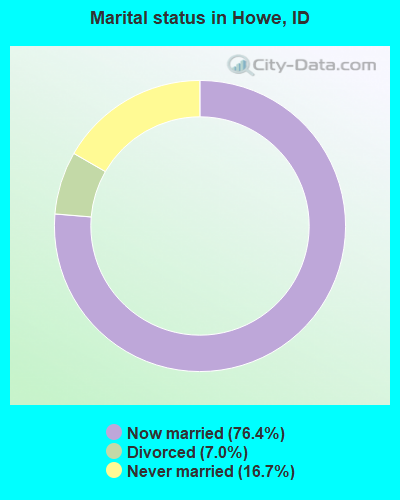
- Never married: 16.7%
- Now married: 76.4%
- Separated: 0.0%
- Widowed: 0.0%
- Divorced: 7.0%
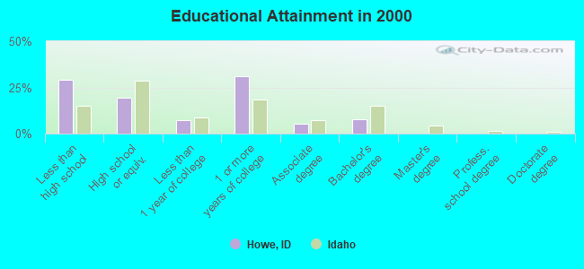
For population 25 years and over in Howe:
- High school or higher: 70.9%
- Bachelor's degree or higher: 7.8%
- Graduate or professional degree: 0.0%
- Unemployed: 1.7%
- Mean travel time to work (commute): 27.3 minutes
| Here: | 16.1 |
| Idaho average: | 11.1 |
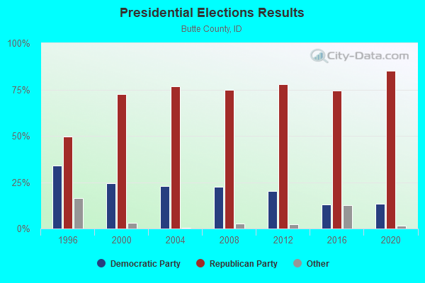
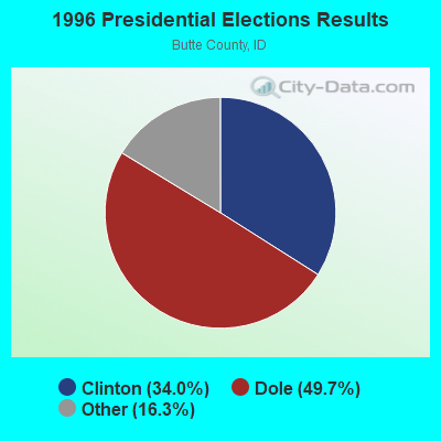
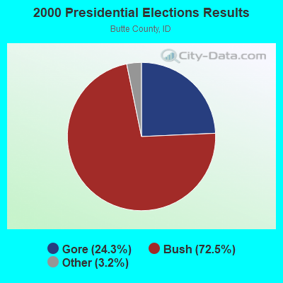
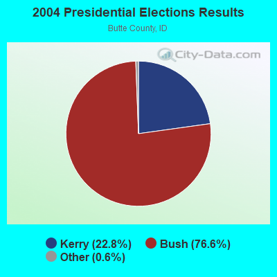
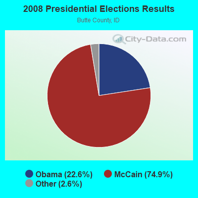
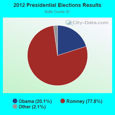
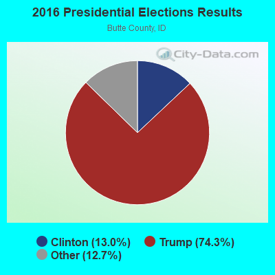
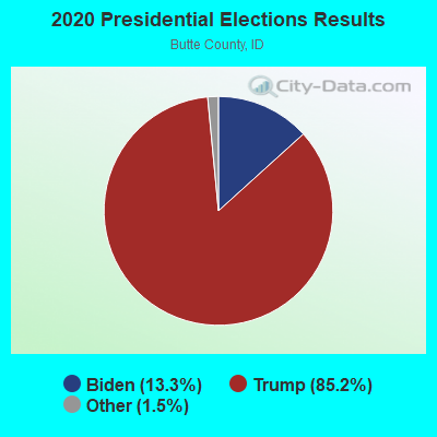
Graphs represent county-level data. Detailed 2008 Election Results
Religion statistics for Howe, ID (based on Butte County data)
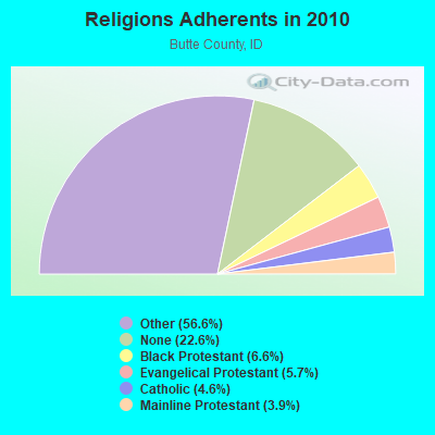
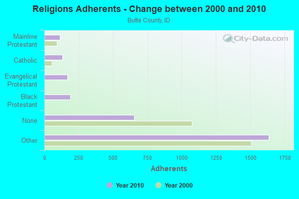
| Religion | Adherents | Congregations |
|---|---|---|
| Other | 1,635 | 6 |
| Black Protestant | 190 | 1 |
| Evangelical Protestant | 166 | 4 |
| Catholic | 132 | 1 |
| Mainline Protestant | 114 | 2 |
| None | 654 | - |
Food Environment Statistics:
| Here: | 3.63 / 10,000 pop. |
| Idaho: | 1.88 / 10,000 pop. |
| This county: | 18.14 / 10,000 pop. |
| Idaho: | 3.87 / 10,000 pop. |
| Butte County: | 10.89 / 10,000 pop. |
| Idaho: | 7.75 / 10,000 pop. |
| Butte County: | 8.7% |
| Idaho: | 7.7% |
| Butte County: | 25.1% |
| Idaho: | 25.7% |
| This county: | 15.0% |
| Idaho: | 11.7% |
Strongest AM radio stations in Howe:
- KZNR (690 AM; 10 kW; BLACKFOOT, ID; Owner: WESTERN COMMUNICATIONS, INC.)
- KBLI (1620 AM; 10 kW; BLACKFOOT, ID; Owner: WESTERN COMMUNICATIONS, INC.)
- KID (590 AM; 5 kW; IDAHO FALLS, ID; Owner: CITICASTERS LICENSES, L.P.)
- KBOI (670 AM; 50 kW; BOISE, ID; Owner: CITADEL BROADCASTING COMPANY)
- KUPI (980 AM; 5 kW; AMMON, ID; Owner: RAY GROTH OIL COMPANY, INC.)
- KSEI (930 AM; 5 kW; POCATELLO, ID; Owner: PACIFIC EMPIRE COMMUNICATIONS CORP.)
- KALL (700 AM; 50 kW; NORTH SALT LAKE CITY, UT; Owner: CITICASTERS LICENSES, L.P.)
- KZNI (1260 AM; 5 kW; IDAHO FALLS, ID)
- KIQN (1010 AM; 50 kW; TOOELE, UT)
- KSL (1160 AM; 50 kW; SALT LAKE CITY, UT; Owner: BONNEVILLE HOLDING COMPANY)
- KWEI (1260 AM; 50 kW; WEISER, ID; Owner: TREASURE VALLEY BROADCASTING CO.)
- KERR (750 AM; 50 kW; POLSON, MT; Owner: ANDERSON RADIO BROADCASTING, INC.)
- KBSU (730 AM; 15 kW; BOISE, ID; Owner: IDAHO STATE BOARD OF EDUCATION)
Strongest FM radio stations in Howe:
- KCVI (101.5 FM; BLACKFOOT, ID; Owner: WESTERN COMMUNICATIONS, INC.)
- KLCE (97.3 FM; BLACKFOOT, ID; Owner: WESTERN COMMUNICATIONS, INC.)
- KID-FM (96.1 FM; IDAHO FALLS, ID; Owner: CITICASTERS LICENSES, L.P.)
- KBJX (107.9 FM; SHELLEY, ID; Owner: PACIFIC EMPIRE COMMUNICATIONS CORP)
TV broadcast stations around Howe:
- K59BV (Channel 59; LAVA HOT SPRINGS, ID; Owner: STATE BOARD OF EDUCATION (IEPBS))
FCC Registered Antenna Towers:
4- Tony Hafla, Hwy 33 Just East Of Howe (Lat: 43.782861 Lon: -112.988472), Type: 55.5, Structure height: 16023 m, Overall height: 55.5 m, Registrant: Teton Communications Inc., Tony@tetoncommunications.Com, , Idaho- Falls, Phone: (208) 522-0750
- Tony Hafla, Hwy 33 Just East Of Howe (Lat: 43.782861 Lon: -112.988472), Type: 55.5, Structure height: 16023 m, Overall height: 55.5 m, Registrant: Teton Communications Inc., Tony@tetoncommunications.Com, , Idaho- Falls, Phone: (208) 522-0750
- Tony Hafla, 1441 Hi-Way 33 (Lat: 43.782861 Lon: -112.988472), Type: 54.9, Structure height: 16023 m, Overall height: 54.9 m, Registrant: Teton Communications Inc., Tony@tetoncommunications.Com, , Idaho- Falls, Phone: (208) 522-0750
- Tony Hafla, 1441 Hi-Way 33 (Lat: 43.782861 Lon: -112.988472), Type: 54.9, Structure height: 16023 m, Overall height: 54.9 m, Registrant: Teton Communications Inc., Tony@tetoncommunications.Com, , Idaho- Falls, Phone: (208) 522-0750
FCC Registered Private Land Mobile Towers:
1- Howe Peak (Lat: 43.713250 Lon: -113.100417), Type: Ltower, Structure height: 28.9 m, Call Sign: WPTR261,
Assigned Frequencies: 856.837 MHz, 857.837 MHz, 858.837 MHz, 859.837 MHz, 860.837 MHz, Grant Date: 10/25/2011, Expiration Date: 11/28/2021, Cancellation Date: 01/15/2022, Certifier: Danny W Crystal, Registrant: White Cloud Communications, Inc., 663 Main St, Twin Falls, ID 83301, Phone: (208) 733-5470, Fax: (208) 235-1778, Email:
FCC Registered Broadcast Land Mobile Towers:
1- 6 Mi E (Lat: 43.796306 Lon: -112.263028), Call Sign: KNEX894,
Assigned Frequencies: 152.945 MHz, Grant Date: 03/23/1998, Expiration Date: 03/16/2003, Cancellation Date: 09/18/2002, Registrant: Russell Mays, Howe, ID 83244
FCC Registered Microwave Towers:
4- Jump Off Point, Jump Off Point, 6 Mi Sw Of (Lat: 43.756028 Lon: -113.100250), Type: Tower, Structure height: 6.1 m, Overall height: 10.1 m, Call Sign: WQNU546,
Assigned Frequencies: 959.150 MHz, Grant Date: 05/15/2021, Expiration Date: 05/31/2031, Certifier: Marcus Kohler, Registrant: Pacificorp, 2001 L Street, Nw, Suite 900, Washington, DC 20036, Phone: (202) 857-2574, Fax: (202) 223-0833, Email:
- Howe Peak, 6.8 Miles Sw Of (Lat: 43.712972 Lon: -113.099806), Type: Tower, Structure height: 9.2 m, Call Sign: WQPH947,
Assigned Frequencies: 11265.0 MHz, 11225.0 MHz, 6212.06 MHz, 6271.36 MHz, 6212.06 MHz, 6271.36 MHz, 6212.06 MHz, 6271.36 MHz, 6212.06 MHz, 6271.36 MHz... (+20 more), Grant Date: 06/14/2022, Expiration Date: 05/23/2032, Certifier: Joseph W Shelton, Registrant: Micronet Communications, Inc., 812 Lexington Dr, Plano, TX 75075, Phone: (972) 422-7200, Email:
- SL04380A, Washington Blvd (Lat: 43.646444 Lon: -112.914778), Type: Ltower, Structure height: 29 m, Overall height: 32 m, Call Sign: WRQI302,
Assigned Frequencies: 17815.0 MHz, 17865.0 MHz, 17815.0 MHz, 17865.0 MHz, 17815.0 MHz, 17865.0 MHz, 17815.0 MHz, 17865.0 MHz, 17815.0 MHz, 17865.0 MHz... (+34 more), Grant Date: 04/26/2022, Expiration Date: 04/26/2032, Certifier: Jenny Knopf, Registrant: T-Mobile Usa, Inc., 12920 Se 38th Street, Bellevue, WA 98006, Phone: (425) 383-8401, Fax: (425) 383-4040, Email:
- SL02330B, 1441 Hi-Way 33 (Lat: 43.782861 Lon: -112.988472), Type: Ltower, Structure height: 54.9 m, Call Sign: WRQI309,
Assigned Frequencies: 19375.0 MHz, 19425.0 MHz, 19375.0 MHz, 19425.0 MHz, 19375.0 MHz, 19425.0 MHz, 19375.0 MHz, 19425.0 MHz, 19375.0 MHz, 19425.0 MHz... (+34 more), Grant Date: 04/26/2022, Expiration Date: 04/26/2032, Certifier: Jenny Knopf, Registrant: T-Mobile Usa, Inc., 12920 Se 38th Street, Bellevue, WA 98006, Phone: (425) 383-8401, Fax: (425) 383-4040, Email:
FCC Registered Amateur Radio Licenses:
3- Call Sign: KB7QAK, Licensee ID: L00596133, Grant Date: 04/06/2013, Expiration Date: 04/06/2023, Registrant: Craig S Barnes, 1572 W. 3600 N., Howe, ID 83244
- Call Sign: WA7FDR, Licensee ID: L00872579, Grant Date: 02/14/2024, Expiration Date: 05/10/2034, Certifier: Vance L Hawley, Registrant: Vance L Hawley, .Middle Of Town On Main St, Howe, ID 83244
- Call Sign: KI7UEI, Licensee ID: L02162812, Grant Date: 02/14/2018, Expiration Date: 02/14/2028, Certifier: Wade W Callister, Registrant: Wade W Callister, 1454 W 3700 N, Howe, ID 83244
FAA Registered Aircraft:
3- Aircraft: CESSNA 182B (Category: Land, Seats: 4, Weight: Up to 12,499 Pounds, Speed: 119 mph), Engine: CONT MOTOR O-470 SERIES (230 HP) (Reciprocating)
N-Number: 2384G, N2384G, N-2384G, Serial Number: 51684, Year manufactured: 1958, Airworthiness Date: 12/17/1958, Certificate Issue Date: 10/08/1986
Registrant (Co-Owned): Charles H Mcdonald, Po Box 45, Howe, ID 83244, Other Owners: Joyce L Mcdonald - Aircraft: AMERICAN CHAMPION AIRCRAFT 7GCBC (Category: Land, Seats: 2, Weight: Up to 12,499 Pounds), Engine: LYCOMING 0-320 SERIES (180 HP) (Reciprocating)
N-Number: 251MA, N251MA, N-251MA, Serial Number: 1346-2003, Year manufactured: 2003, Airworthiness Date: 08/20/2003, Certificate Issue Date: 01/19/2018
Registrant (Individual): Robert J Norris, 3842 N 1800 W, Howe, ID 83244 - Aircraft: ANGUS WATT ZENAIR STOLCH 750 (Category: Land, Seats: 2, Weight: Up to 12,499 Pounds), Engine: JABIRU 3300 (120 HP) (Reciprocating)
N-Number: 750RH, N750RH, N-750RH, Serial Number: 75-7832, Year manufactured: 2009, Airworthiness Date: 11/26/2011, Certificate Issue Date: 10/20/2016
Registrant (Co-Owned): Charles H Mcdonald, Po Box 45, Howe, ID 83244, Other Owners: Joyce L Mcdonald
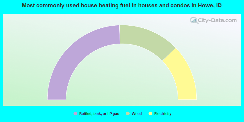
- 48.9%Bottled, tank, or LP gas
- 26.7%Wood
- 24.4%Electricity
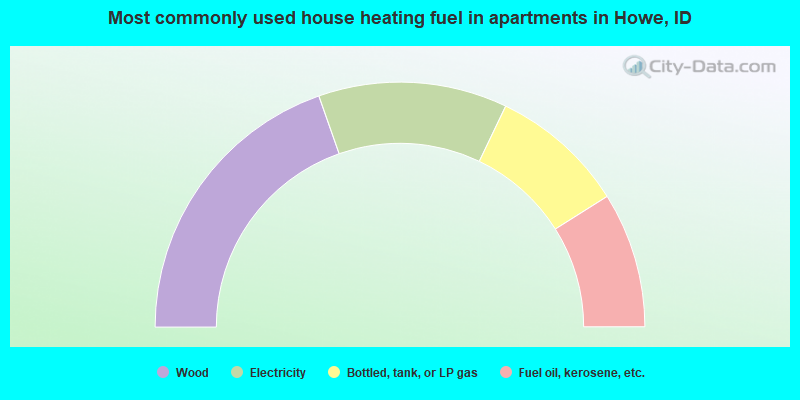
- 39.3%Wood
- 25.0%Electricity
- 17.9%Bottled, tank, or LP gas
- 17.9%Fuel oil, kerosene, etc.
Howe compared to Idaho state average:
- Median household income below state average.
- Unemployed percentage significantly below state average.
- Black race population percentage significantly below state average.
- Hispanic race population percentage below state average.
- Median age significantly below state average.
- Foreign-born population percentage significantly below state average.
- Length of stay since moving in significantly above state average.
- Number of rooms per house significantly below state average.
- House age significantly below state average.
- Number of college students significantly below state average.
- Percentage of population with a bachelor's degree or higher significantly below state average.