Huntsville, Georgia
Submit your own pictures of this place and show them to the world
- OSM Map
- General Map
- Google Map
- MSN Map

| Males: 11,370 | |
| Females: 10,808 |
| Median resident age: | 32.3 years |
| Georgia median age: | 33.4 years |
Zip code: 30132
| Huntsville: | $98,409 |
| GA: | $72,837 |
Estimated per capita income in 2022: $37,614 (it was $22,122 in 2000)
Huntsville CCD income, earnings, and wages data
Estimated median house or condo value in 2022: $377,835 (it was $125,300 in 2000)
| Huntsville: | $377,835 |
| GA: | $297,400 |
Detailed information about poverty and poor residents in Huntsville, GA


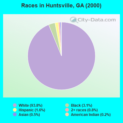
- 13,49793.8%White alone
- 4423.1%Black alone
- 2371.6%Hispanic
- 1130.8%Two or more races
- 650.5%Asian alone
- 270.2%American Indian alone
- 70.05%Other race alone
- 50.03%Native Hawaiian and Other
Pacific Islander alone
Races in Huntsville detailed stats: ancestries, foreign born residents, place of birth
 Recent articles from our blog. Our writers, many of them Ph.D. graduates or candidates, create easy-to-read articles on a wide variety of topics.
Current Local Time: EST time zone
Land area: 100.1 square miles.
Population density: 222 people per square mile (very low).
| Huntsville CCD: | 0.8% ($1,015) |
| Georgia: | 0.9% ($919) |
Nearest city with pop. 50,000+: Marietta, GA  (16.9 miles , pop. 58,748).
Nearest city with pop. 200,000+: Atlanta, GA (30.1 miles , pop. 416,474).
Nearest city with pop. 1,000,000+: Chicago, IL (562.8 miles , pop. 2,896,016).
Nearest cities:
), Latitude: 34.02 N, Longitude: 84.82 W

| Here: | 2.6% |
| Georgia: | 2.9% |
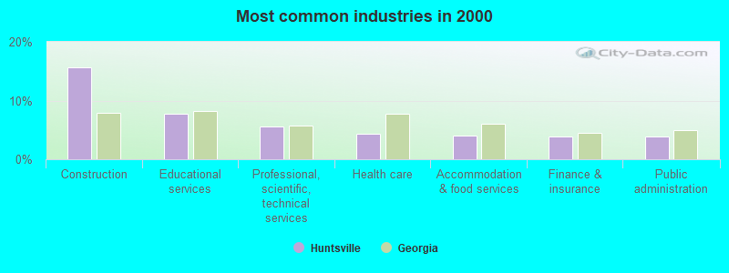
- Construction (15.6%)
- Educational services (7.7%)
- Professional, scientific, technical services (5.6%)
- Health care (4.3%)
- Accommodation & food services (4.0%)
- Finance & insurance (3.9%)
- Public administration (3.9%)
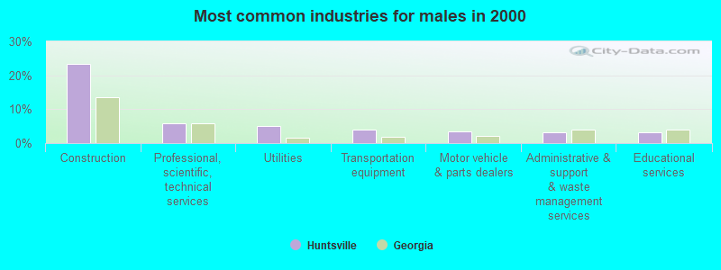
- Construction (23.3%)
- Professional, scientific, technical services (6.0%)
- Utilities (5.1%)
- Transportation equipment (3.9%)
- Motor vehicle & parts dealers (3.3%)
- Administrative & support & waste management services (3.3%)
- Educational services (3.1%)
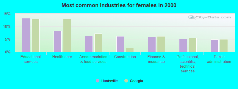
- Educational services (13.3%)
- Health care (8.3%)
- Accommodation & food services (6.3%)
- Construction (6.2%)
- Finance & insurance (6.0%)
- Professional, scientific, technical services (5.1%)
- Public administration (4.9%)
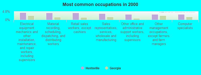
- Electrical equipment mechanics and other installation, maintenance, and repair workers, including supervisors (4.2%)
- Material recording, scheduling, dispatching, and distributing workers (4.1%)
- Retail sales workers, except cashiers (4.0%)
- Sales representatives, services, wholesale and manufacturing (3.6%)
- Other office and administrative support workers, including supervisors (3.2%)
- Other management occupations, except farmers and farm managers (3.2%)
- Computer specialists (3.2%)
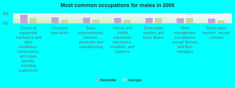
- Electrical equipment mechanics and other installation, maintenance, and repair workers, including supervisors (7.3%)
- Computer specialists (5.0%)
- Sales representatives, services, wholesale and manufacturing (4.9%)
- Vehicle and mobile equipment mechanics, installers, and repairers (4.6%)
- Driver/sales workers and truck drivers (4.6%)
- Other management occupations, except farmers and farm managers (4.3%)
- Retail sales workers, except cashiers (4.2%)
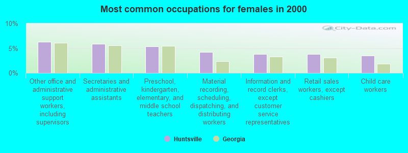
- Other office and administrative support workers, including supervisors (6.3%)
- Secretaries and administrative assistants (5.8%)
- Preschool, kindergarten, elementary, and middle school teachers (5.4%)
- Material recording, scheduling, dispatching, and distributing workers (4.3%)
- Information and record clerks, except customer service representatives (3.8%)
- Retail sales workers, except cashiers (3.8%)
- Child care workers (3.5%)
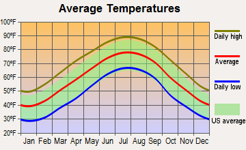
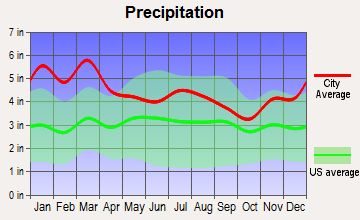
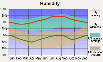
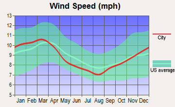
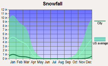
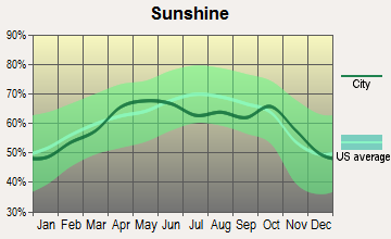
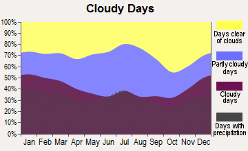
Average climate in Huntsville, Georgia
Based on data reported by over 4,000 weather stations
(lower is better)
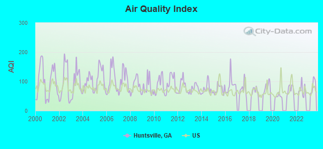
Air Quality Index (AQI) level in 2022 was 69.8. This is about average.
| City: | 69.8 |
| U.S.: | 72.6 |
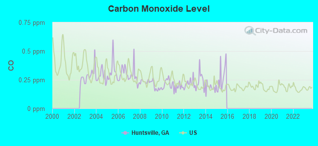
Carbon Monoxide (CO) [ppm] level in 2015 was 0.248. This is about average. Closest monitor was 14.2 miles away from the city center.
| City: | 0.248 |
| U.S.: | 0.251 |
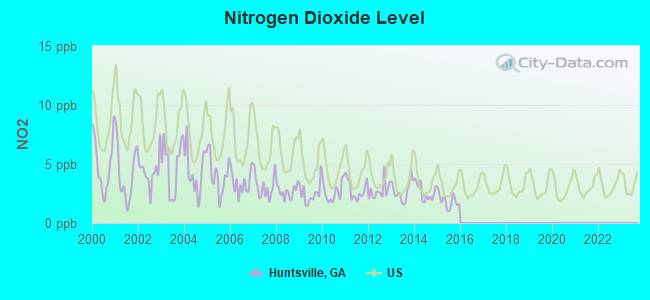
Nitrogen Dioxide (NO2) [ppb] level in 2015 was 1.87. This is significantly better than average. Closest monitor was 14.2 miles away from the city center.
| City: | 1.87 |
| U.S.: | 5.11 |
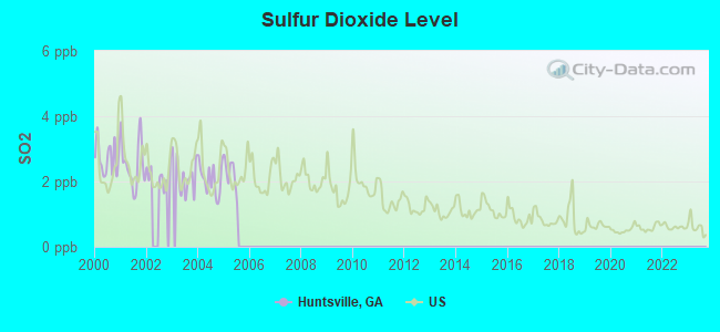
Sulfur Dioxide (SO2) [ppb] level in 2005 was 2.23. This is significantly worse than average. Closest monitor was 7.8 miles away from the city center.
| City: | 2.23 |
| U.S.: | 1.51 |
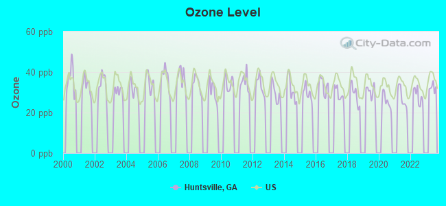
Ozone [ppb] level in 2022 was 28.3. This is about average. Closest monitor was 4.6 miles away from the city center.
| City: | 28.3 |
| U.S.: | 33.3 |
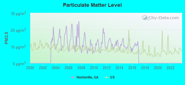
Particulate Matter (PM2.5) [µg/m3] level in 2016 was 10.3. This is worse than average. Closest monitor was 12.4 miles away from the city center.
| City: | 10.3 |
| U.S.: | 8.1 |
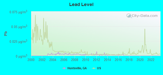
Lead (Pb) [µg/m3] level in 2016 was 0.00153. This is significantly better than average. Closest monitor was 14.2 miles away from the city center.
| City: | 0.00153 |
| U.S.: | 0.00931 |
Tornado activity:
Huntsville-area historical tornado activity is above Georgia state average. It is 79% greater than the overall U.S. average.
On 11/22/1992, a category F4 (max. wind speeds 207-260 mph) tornado 11.2 miles away from the Huntsville place center injured 46 people and caused between $5,000,000 and $50,000,000 in damages.
On 3/27/1994, a category F4 tornado 14.1 miles away from the place center killed 3 people and injured 20 people and caused between $5,000,000 and $50,000,000 in damages.
Earthquake activity:
Huntsville-area historical earthquake activity is significantly above Georgia state average. It is 74% greater than the overall U.S. average.On 4/29/2003 at 08:59:39, a magnitude 4.9 (4.4 MB, 4.6 MW, 4.9 LG, Class: Light, Intensity: IV - V) earthquake occurred 56.5 miles away from Huntsville center
On 4/29/2003 at 08:59:39, a magnitude 4.6 (4.6 MW, Depth: 12.3 mi) earthquake occurred 56.6 miles away from Huntsville center
On 8/2/1974 at 08:52:09, a magnitude 4.9 (4.3 MB, 4.9 LG) earthquake occurred 134.4 miles away from the city center
On 1/18/1999 at 07:00:53, a magnitude 4.8 (4.8 MB, 4.0 LG, Depth: 0.6 mi) earthquake occurred 146.2 miles away from the city center
On 11/30/1973 at 07:48:41, a magnitude 4.7 (4.7 MB, 4.6 ML) earthquake occurred 132.4 miles away from the city center
On 12/12/2018 at 09:14:43, a magnitude 4.4 (4.4 MW, Depth: 4.9 mi) earthquake occurred 110.2 miles away from the city center
Magnitude types: regional Lg-wave magnitude (LG), body-wave magnitude (MB), local magnitude (ML), moment magnitude (MW)
Natural disasters:
The number of natural disasters in Paulding County (11) is smaller than the US average (15).Major Disasters (Presidential) Declared: 6
Emergencies Declared: 4
Causes of natural disasters: Floods: 3, Winter Storms: 3, Hurricanes: 2, Storms: 2, Tornadoes: 2, Drought: 1, Snowfall: 1, Other: 1 (Note: some incidents may be assigned to more than one category).
Hospitals and medical centers near Huntsville:
- PAULDING DIALYSIS (Dialysis Facility, about 8 miles away; DALLAS, GA)
- WELLSTAR PAULDING HOSPITAL Acute Care Hospitals (about 8 miles away; DALLAS, GA)
- FRESENIUS MEDICAL CARE HIRAM (Dialysis Facility, about 9 miles away; HIRAM, GA)
- TOWNSEND PARK HEALTH AND REHABILITATION (Nursing Home, about 10 miles away; CARTERSVILLE, GA)
- DSI CARTERSVILLE RENAL CENTER (Dialysis Facility, about 11 miles away; CARTERSVILLE, GA)
- CARTERSVILLE HEIGHTS CARE AND REHABILITATION CTR (Nursing Home, about 12 miles away; CARTERSVILLE, GA)
- SPRINGDALE HEALTH CARE CENTER (Nursing Home, about 12 miles away; CARTERSVILLE, GA)
Colleges/universities with over 2000 students nearest to Huntsville:
- Kennesaw State University (about 14 miles; Kennesaw, GA; Full-time enrollment: 21,215)
- Chattahoochee Technical College (about 17 miles; Marietta, GA; FT enrollment: 8,173)
- Southern Polytechnic State University (about 19 miles; Marietta, GA; FT enrollment: 5,258)
- Georgia Highlands College (about 25 miles; Rome, GA; FT enrollment: 4,071)
- Georgia Northwestern Technical College (about 25 miles; Rome, GA; FT enrollment: 4,629)
- The Art Institute of Atlanta (about 28 miles; Atlanta, GA; FT enrollment: 3,140)
- Berry College (about 29 miles; Mount Berry, GA; FT enrollment: 2,102)
Points of interest:
Notable locations in Huntsville: Burnt Hickory Ridge (A), Cross Trails (B), Paulding County Fire and Rescue Bureau Training Facility (C), Paulding County Fire and Rescue Bureau Station 8 (D), Paulding County Fire and Rescue Bureau Station 6 (E). Display/hide their locations on the map
Churches in Huntsville include: Pathway Church (A), Cross Roads Church (B), Mount Moriah Church (C), Mount Zion Church (D), Narroway Church (E), Northside Church (F), High Shoals Church (G), Harmony Grove Church (H), Friendship Church (I). Display/hide their locations on the map
Cemeteries: Cross Roads Cemetery (1), Friendship Cemetery (2), High Shoals Cemetery (3), Mount Moriah Cemetery (4), Mount Zion Cemetery (5), Narroway Cemetery (6), New Hope Cemetery (7). Display/hide their locations on the map
Reservoirs: Carnes Lake (A), Corley Lake (B), Blair Lake (C), Pegamore Lake (D), Benson Lake (E), Collins Lake (F), Camp Lake (G). Display/hide their locations on the map
Streams, rivers, and creeks: Westbrook Creek (A), West Fork Pumpkinvine Creek (B), Raper Creek (C), Goodwin Branch (D), Dunaway Branch (E), Cochran Branch (F), Bone Creek (G), Possum Creek (H), Picketts Mill Creek (I). Display/hide their locations on the map
Park in Huntsville: Picketts Mill State Historical Site (1). Display/hide its location on the map
| This place: | 2.9 people |
| Georgia: | 2.6 people |
| This place: | 77.8% |
| Whole state: | 70.7% |
| This place: | 4.0% |
| Whole state: | 4.8% |
Likely homosexual households (counted as self-reported same-sex unmarried-partner households)
- Lesbian couples: 0.2% of all households
- Gay men: 0.2% of all households
| This place: | 3.3% |
| Whole state: | 13.0% |
| This place: | 1.9% |
| Whole state: | 6.1% |
101 people in short-term care, detention or diagnostic centers for delinquent children in 2000
For population 15 years and over in Huntsville:
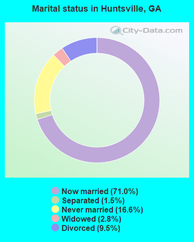
- Never married: 16.6%
- Now married: 71.0%
- Separated: 1.5%
- Widowed: 2.8%
- Divorced: 9.5%
For population 25 years and over in Huntsville:
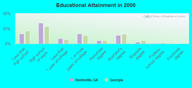
- High school or higher: 83.3%
- Bachelor's degree or higher: 18.5%
- Graduate or professional degree: 4.3%
- Unemployed: 1.5%
- Mean travel time to work (commute): 38.3 minutes
| Here: | 9.9 |
| Georgia average: | 13.3 |
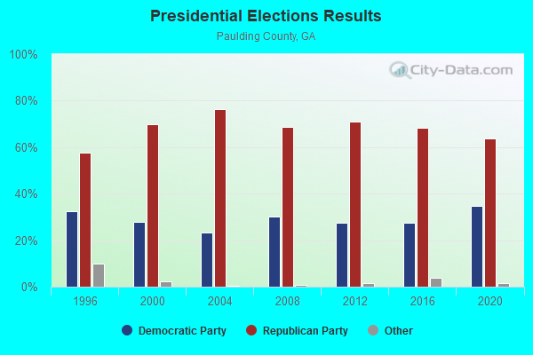
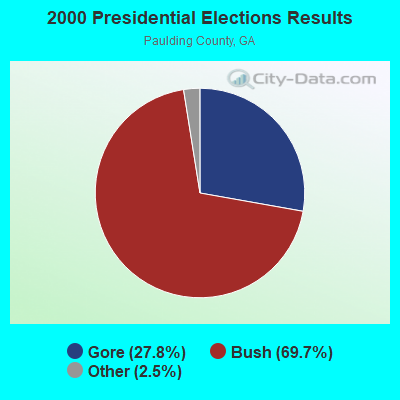
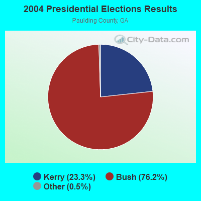
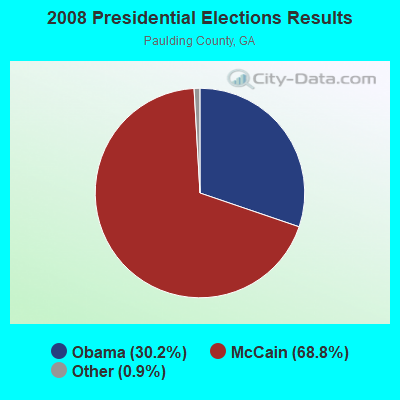

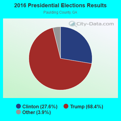

Graphs represent county-level data. Detailed 2008 Election Results
Religion statistics for Huntsville, GA (based on Paulding County data)
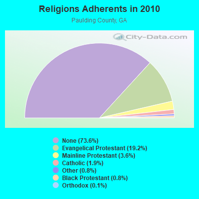
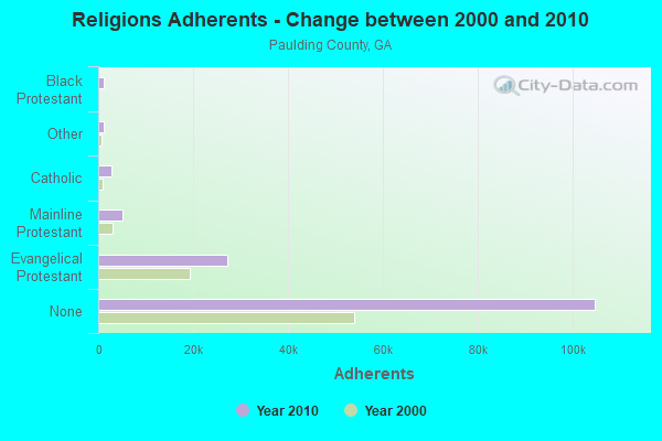
| Religion | Adherents | Congregations |
|---|---|---|
| Evangelical Protestant | 27,282 | 62 |
| Mainline Protestant | 5,138 | 14 |
| Catholic | 2,714 | 1 |
| Other | 1,163 | 4 |
| Black Protestant | 1,112 | 6 |
| Orthodox | 160 | 1 |
| None | 104,755 | - |
Food Environment Statistics:
| Paulding County: | 0.78 / 10,000 pop. |
| State: | 1.91 / 10,000 pop. |
| Paulding County: | 0.24 / 10,000 pop. |
| Georgia: | 0.15 / 10,000 pop. |
| Paulding County: | 0.31 / 10,000 pop. |
| State: | 0.86 / 10,000 pop. |
| Here: | 2.82 / 10,000 pop. |
| Georgia: | 5.12 / 10,000 pop. |
| This county: | 4.31 / 10,000 pop. |
| State: | 7.41 / 10,000 pop. |
| This county: | 10.0% |
| Georgia: | 10.4% |
| Paulding County: | 29.5% |
| Georgia: | 27.8% |
| Here: | 11.0% |
| Georgia: | 14.6% |
Businesses in Huntsville, GA
- Ethan Allen: 1
Strongest AM radio stations in Huntsville:
- WFTD (1080 AM; daytime; 50 kW; MARIETTA, GA; Owner: PRIETO ENTERPRISES, INC.)
- WMLB (1160 AM; 50 kW; EAST POINT, GA; Owner: ATLANTA AREA BROADCASTING, INC.)
- WDPC (1500 AM; 5 kW; DALLAS, GA; Owner: WORD CHRISTIAN BROADCASTING, INC.)
- WGST (640 AM; 50 kW; ATLANTA, GA; Owner: CITICASTERS LICENSES, L.P.)
- WAZX (1550 AM; 50 kW; SMYRNA, GA; Owner: GA-MEX BROADCASTING, INC.)
- WCNN (680 AM; 50 kW; NORTH ATLANTA, GA; Owner: DICKEY BROADCASTING COMPANY)
- WSB (750 AM; 50 kW; ATLANTA, GA; Owner: CXR HOLDINGS, INC.)
- WAOK (1380 AM; 50 kW; ATLANTA, GA; Owner: INFINITY BROADCASTING OPERATIONS, INC.)
- WKNG (1060 AM; daytime; 50 kW; TALLAPOOSA, GA; Owner: WKNG, INC.)
- WAOS (1600 AM; 20 kW; AUSTELL, GA; Owner: LA FAVORITA, INC.)
- WQXI (790 AM; 28 kW; ATLANTA, GA; Owner: JEFFERSON-PILOT COMMUNICATIONS COMPANY OF GEORGIA)
- WGUN (1010 AM; 50 kW; ATLANTA, GA; Owner: WGUN, INC.)
- WDWD (590 AM; 5 kW; ATLANTA, GA; Owner: ABC, INC.)
Strongest FM radio stations in Huntsville:
- WCCV (91.7 FM; CARTERSVILLE, GA; Owner: IMMANUEL BROADCASTING NETWORK, INC.)
- W214AS (90.7 FM; WALESKA, GA; Owner: CALVARY CHAPEL OF TWIN FALLS, INC.)
- W221AW (92.1 FM; NORTH CANTON, GA; Owner: IMMANUEL BROADCASTING NETWORK, INC.)
- WJCK (88.3 FM; PIEDMONT, AL; Owner: IMMANUEL BROADCASTING NETWORK, INC.)
- WLCL (105.7 FM; CANTON, GA; Owner: CHEROKEE BROADCASTING CO., INC.)
- W265BD (100.9 FM; WOODSTOCK, GA; Owner: IMMANUEL BROADCASTING NETWORK, INC.)
- WWWQ (100.5 FM; ANNISTON, AL; Owner: WNNX LICO, INC.)
- WNNX (99.7 FM; ATLANTA, GA; Owner: WNNX LICO, INC.)
- WTSH-FM (107.1 FM; ROCKMART, GA; Owner: BROADCAST INVESTMENT ASSOCIATES, INC)
- WKHX-FM (101.5 FM; MARIETTA, GA; Owner: ABC, INC.)
- WRFG (89.3 FM; ATLANTA, GA; Owner: RADIO FREE GEORGIA BROADCASTING FOUNDATION INC)
- W215BA (90.9 FM; ROME, GA; Owner: PENSACOLA CHRISTIAN COLLEGE, INC.)
- WKLS (96.1 FM; ATLANTA, GA; Owner: CITICASTERS LICENSES, L.P.)
- WLTM (94.9 FM; ATLANTA, GA; Owner: CITICASTERS LICENSES, L.P.)
- WSB-FM (98.5 FM; ATLANTA, GA; Owner: CXR HOLDINGS, INC.)
- WSTR (94.1 FM; SMYRNA, GA; Owner: JEFFERSON-PILOT COMMUNICATIONS COMPANY OF GEORGIA)
- WVEE (103.3 FM; ATLANTA, GA; Owner: INFINITY BROADCASTING OPERATIONS, INC.)
- WZGC (92.9 FM; ATLANTA, GA; Owner: INFINITY BROADCASTING CORP. OF ATLANTA)
- WKCX (97.7 FM; ROME, GA; Owner: BRIAR CREEK BROADCASTING CORP.)
- WQTU (102.3 FM; ROME, GA; Owner: MCDOUGALD BROADCASTING CORPORATION)
TV broadcast stations around Huntsville:
- WUVG (Channel 34; ATHENS, GA; Owner: UNIVISION ATLANTA LLC)
- WSKC-LP (Channel 59; ATLANTA, GA; Owner: KM LPTV OF ATLANTA, L.L.C.)
- WAGA (Channel 5; ATLANTA, GA; Owner: FOX TELEVISION STATIONS, INC.)
- WSB-TV (Channel 2; ATLANTA, GA; Owner: WSB-TV HOLDINGS, INC.)
- WPXA (Channel 14; ROME, GA; Owner: PAXSON ATLANTA LICENSE, INC.)
- WXIA-TV (Channel 11; ATLANTA, GA; Owner: GANNETT GEORGIA, L.P.)
- WATL (Channel 36; ATLANTA, GA; Owner: WATL, LLC)
- WTBS (Channel 17; ATLANTA, GA; Owner: SUPERSTATION, INC.)
- WGCL-TV (Channel 46; ATLANTA, GA; Owner: MEREDITH CORPORATION)
- WHSG (Channel 63; MONROE, GA; Owner: TRINITY BROADCASTING NETWORK)
- WANN-LP (Channel 32; ATLANTA, GA; Owner: PRISM BROADCASTING NETWORK, INC.)
- WDTA-LP (Channel 53; FAYETTEVILLE, GA; Owner: WORD OF GOD FELLOWSHIP, INC.)
- WUPA (Channel 69; ATLANTA, GA; Owner: VIACOM STATIONS GROUP OF ATLANTA INC.)
- WPBA (Channel 30; ATLANTA, GA; Owner: BOARD OF EDUCATION OF THE CITY OF ATLANTA)
- WTHC-LP (Channel 42; ATLANTA, GA; Owner: THE ATLANTA CHANNEL, INC.)
- WIRE-CA (Channel 40; ATLANTA, GA; Owner: COMMERCIAL BROADCASTING CORP.)
- WANX-LP (Channel 26; ATLANTA, GA; Owner: PRISM BROADCASTING NETWORK, INC.)
- W04DB (Channel 4; ATLANTA, GA; Owner: VVILPTV, INC.)
- W24AL (Channel 24; ATLANTA, GA; Owner: VENTANA TELEVISION, INC.)
- W38CU (Channel 38; ATLANTA, GA; Owner: KOREAN AMERICAN TV BROADCASTING CORP.)
- WATC (Channel 57; ATLANTA, GA; Owner: COMMUNITY TELEVISION, INC.)
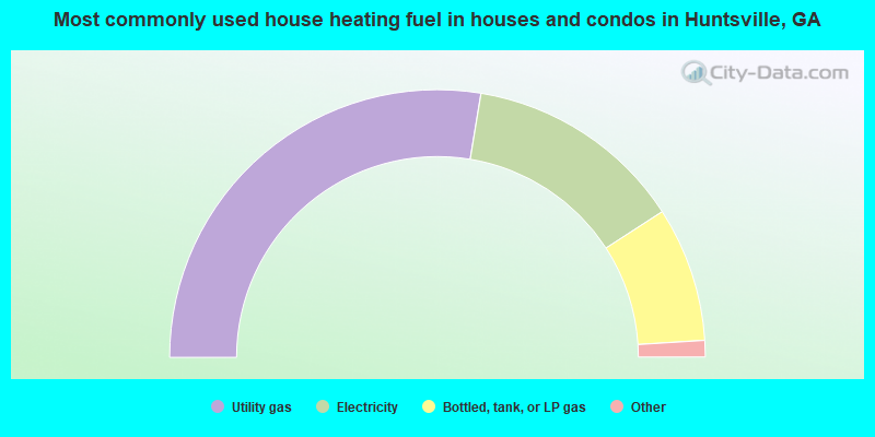
- 55.2%Utility gas
- 26.5%Electricity
- 16.3%Bottled, tank, or LP gas
- 1.6%Wood
- 0.2%Other fuel
- 0.2%Fuel oil, kerosene, etc.
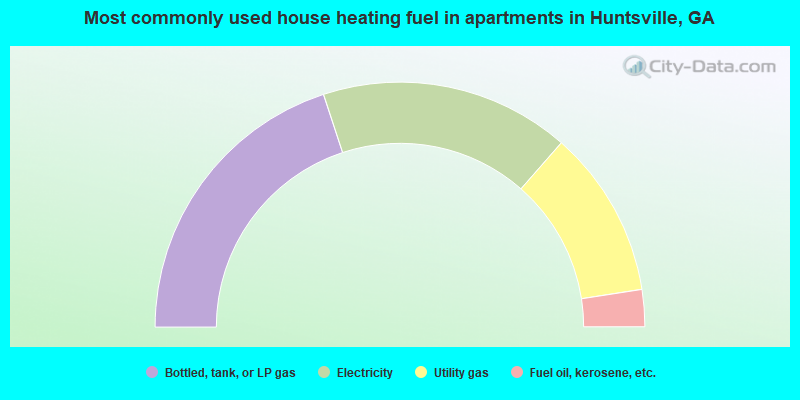
- 39.9%Bottled, tank, or LP gas
- 33.0%Electricity
- 22.2%Utility gas
- 4.9%Fuel oil, kerosene, etc.
Huntsville compared to Georgia state average:
- Unemployed percentage significantly below state average.
- Black race population percentage significantly below state average.
- Hispanic race population percentage significantly below state average.
- Median age below state average.
- Foreign-born population percentage significantly below state average.
- Renting percentage significantly below state average.
- Length of stay since moving in significantly above state average.
- Number of rooms per house significantly below state average.
- House age significantly below state average.
- Institutionalized population percentage significantly above state average.
Huntsville on our top lists:
- #5 on the list of "Top 101 cities with largest percentage of females in industries: machinery, equipment, and supplies merchant wholesalers (population 5,000+)"
- #8 on the list of "Top 101 cities with largest percentage of females in industries: building material and garden equipment and supplies dealers (population 5,000+)"
- #14 on the list of "Top 101 cities with largest percentage of females in occupations: supervisors of construction and extraction workers (population 5,000+)"
- #22 on the list of "Top 101 cities with largest percentage of males in occupations: pipelayers, plumbers, pipefitters, and steamfitters (population 5,000+)"
- #30 on the list of "Top 101 cities with largest percentage of females in industries: professional and commercial equipment and supplies merchant wholesalers (population 5,000+)"
- #41 on the list of "Top 101 cities with the largest percentage of people in short-term care, detention or diagnostic centers for delinquent children (population 1,000+)"
- #41 on the list of "Top 101 cities with largest percentage of females in industries: construction (population 5,000+)"
- #46 on the list of "Top 101 cities with largest percentage of females in occupations: plant and system operators (population 5,000+)"
- #48 on the list of "Top 101 cities with largest percentage of females in industries: electrical and electronic goods merchant wholesalers (population 5,000+)"
- #49 on the list of "Top 101 cities with largest percentage of females in occupations: electricians (population 5,000+)"
- #51 on the list of "Top 101 cities with largest percentage of females in occupations: painters and paperhangers (population 5,000+)"
- #51 on the list of "Top 101 cities with largest percentage of males in occupations: supervisors of construction and extraction workers (population 5,000+)"
- #54 on the list of "Top 101 cities with largest percentage of males in industries: lumber and other construction materials merchant wholesalers (population 5,000+)"
- #69 on the list of "Top 101 cities with largest percentage of males in industries: building material and garden equipment and supplies dealers (population 5,000+)"
- #77 on the list of "Top 101 cities with largest percentage of females in industries: truck transportation (population 5,000+)"
- #82 on the list of "Top 101 cities with largest percentage of males in industries: miscellaneous nondurable goods merchant wholesalers (population 5,000+)"
- #92 on the list of "Top 101 cities with largest percentage of males in industries: miscellaneous durable goods merchant wholesalers (population 5,000+)"
- #93 on the list of "Top 101 cities with largest percentage of males in industries: rail transportation (population 5,000+)"
- #95 on the list of "Top 101 cities with largest percentage of males in industries: warehousing and storage (population 5,000+)"
- #9 on the list of "Top 101 counties with the lowest lead air pollution readings in 2012 (µg/m3)"
- #14 on the list of "Top 101 counties with the highest lead air pollution readings in 2012 (µg/m3)"
- #21 on the list of "Top 101 counties with the highest carbon monoxide air pollution readings in 2012 (ppm)"
- #30 on the list of "Top 101 counties with the lowest number of deaths per 1000 residents 2007-2013 (pop. 50,000+)"
- #43 on the list of "Top 101 counties with the lowest ground withdrawal of fresh water for public supply (pop. 50,000+)"

|
Total of 1 patent application in 2008-2024.