Inverness, Alabama
Submit your own pictures of this place and show them to the world
- OSM Map
- General Map
- Google Map
- MSN Map

| Males: 803 | |
| Females: 915 |
| Median resident age: | 37.0 years |
| Alabama median age: | 35.8 years |
Zip code: 36005
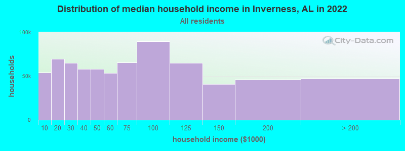
| Inverness: | $42,429 |
| AL: | $59,674 |
Estimated per capita income in 2022: $26,315 (it was $11,938 in 2000)
Inverness CCD income, earnings, and wages data
Estimated median house or condo value in 2022: $110,032 (it was $60,500 in 2000)
| Inverness: | $110,032 |
| AL: | $200,900 |
Mean prices in 2022: all housing units: $195,940; detached houses: $255,062; mobile homes: $110,612
Detailed information about poverty and poor residents in Inverness, AL


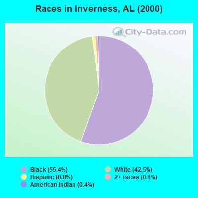
- 1,00855.4%Black alone
- 77342.5%White alone
- 140.8%Two or more races
- 150.8%Hispanic
- 80.4%American Indian alone
 Recent articles from our blog. Our writers, many of them Ph.D. graduates or candidates, create easy-to-read articles on a wide variety of topics.
Current Local Time: CST time zone
Elevation: 417 feet
Land area: 169.4 square miles.
Population density: 10 people per square mile (very low).

| Inverness CCD: | 0.3% ($199) |
| Alabama: | 0.4% ($289) |
Nearest city with pop. 50,000+: Montgomery, AL  (40.8 miles , pop. 201,568).
Nearest city with pop. 1,000,000+: Houston, TX (591.6 miles , pop. 1,953,631).
Nearest cities:
), ), ), ), ), ), )Latitude: 31.97 N, Longitude: 85.75 W
Area code commonly used in this area: 334

| Here: | 2.3% |
| Alabama: | 2.6% |
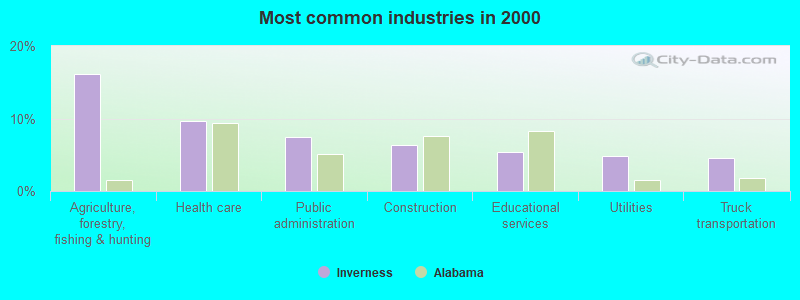
- Agriculture, forestry, fishing & hunting (16.1%)
- Health care (9.6%)
- Public administration (7.4%)
- Construction (6.3%)
- Educational services (5.4%)
- Utilities (4.8%)
- Truck transportation (4.5%)
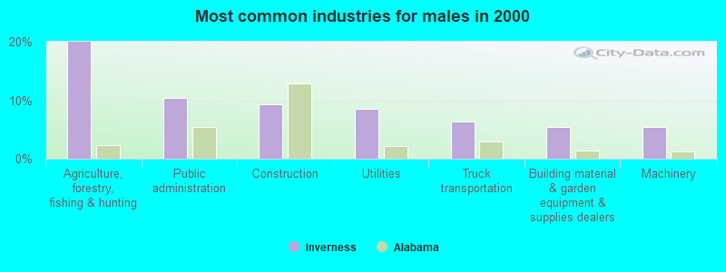
- Agriculture, forestry, fishing & hunting (20.0%)
- Public administration (10.4%)
- Construction (9.3%)
- Utilities (8.5%)
- Truck transportation (6.3%)
- Building material & garden equipment & supplies dealers (5.5%)
- Machinery (5.5%)
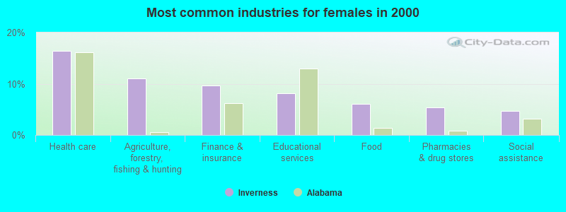
- Health care (16.4%)
- Agriculture, forestry, fishing & hunting (11.0%)
- Finance & insurance (9.6%)
- Educational services (8.2%)
- Food (6.0%)
- Pharmacies & drug stores (5.3%)
- Social assistance (4.6%)
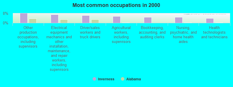
- Other production occupations, including supervisors (8.0%)
- Electrical equipment mechanics and other installation, maintenance, and repair workers, including supervisors (7.0%)
- Driver/sales workers and truck drivers (6.2%)
- Agricultural workers, including supervisors (5.6%)
- Bookkeeping, accounting, and auditing clerks (4.8%)
- Nursing, psychiatric, and home health aides (4.8%)
- Health technologists and technicians (3.9%)
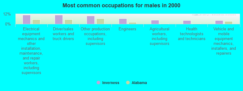
- Electrical equipment mechanics and other installation, maintenance, and repair workers, including supervisors (11.0%)
- Driver/sales workers and truck drivers (11.0%)
- Other production occupations, including supervisors (9.9%)
- Engineers (6.6%)
- Agricultural workers, including supervisors (4.7%)
- Health technologists and technicians (4.4%)
- Vehicle and mobile equipment mechanics, installers, and repairers (4.4%)
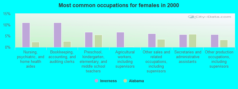
- Nursing, psychiatric, and home health aides (11.0%)
- Bookkeeping, accounting, and auditing clerks (11.0%)
- Preschool, kindergarten, elementary, and middle school teachers (6.8%)
- Agricultural workers, including supervisors (6.8%)
- Other sales and related occupations, including supervisors (6.0%)
- Secretaries and administrative assistants (5.7%)
- Other production occupations, including supervisors (5.7%)
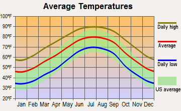
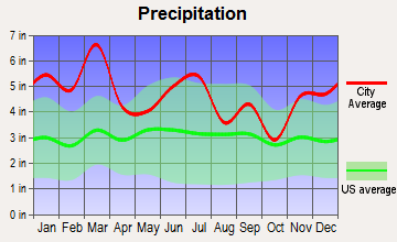
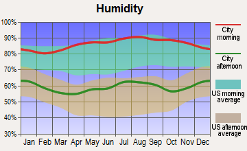
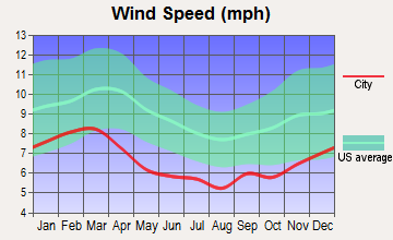
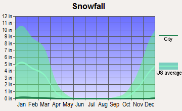
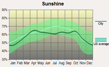
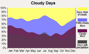
Average climate in Inverness, Alabama
Based on data reported by over 4,000 weather stations
(lower is better)
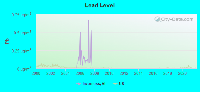
Lead (Pb) [µg/m3] level in 2007 was 0.230. This is significantly worse than average. Closest monitor was 18.3 miles away from the city center.
| City: | 0.230 |
| U.S.: | 0.009 |
Tornado activity:
Inverness-area historical tornado activity is slightly below Alabama state average. It is 41% greater than the overall U.S. average.
On 4/18/1969, a category F4 (max. wind speeds 207-260 mph) tornado 18.5 miles away from the Inverness place center killed 2 people and injured 14 people and caused between $50,000 and $500,000 in damages.
On 12/19/1974, a category F3 (max. wind speeds 158-206 mph) tornado 10.0 miles away from the place center caused between $50,000 and $500,000 in damages.
Earthquake activity:
Inverness-area historical earthquake activity is significantly above Alabama state average. It is 38% greater than the overall U.S. average.On 10/24/1997 at 08:35:17, a magnitude 4.9 (4.8 MB, 4.2 MS, 4.9 LG, Depth: 6.2 mi, Class: Light, Intensity: IV - V) earthquake occurred 107.1 miles away from Inverness center
On 1/18/1999 at 07:00:53, a magnitude 4.8 (4.8 MB, 4.0 LG, Depth: 0.6 mi) earthquake occurred 132.0 miles away from the city center
On 4/29/2003 at 08:59:39, a magnitude 4.9 (4.4 MB, 4.6 MW, 4.9 LG) earthquake occurred 174.4 miles away from Inverness center
On 8/2/1974 at 08:52:09, a magnitude 4.9 (4.3 MB, 4.9 LG) earthquake occurred 230.6 miles away from Inverness center
On 4/29/2003 at 08:59:39, a magnitude 4.6 (4.6 MW, Depth: 12.3 mi) earthquake occurred 174.4 miles away from Inverness center
On 6/24/1975 at 11:11:36, a magnitude 4.5 (4.5 MB) earthquake occurred 171.0 miles away from the city center
Magnitude types: regional Lg-wave magnitude (LG), body-wave magnitude (MB), surface-wave magnitude (MS), moment magnitude (MW)
Natural disasters:
The number of natural disasters in Bullock County (17) is near the US average (15).Major Disasters (Presidential) Declared: 11
Emergencies Declared: 5
Causes of natural disasters: Storms: 9, Floods: 8, Tornadoes: 8, Hurricanes: 5, Winds: 5, Drought: 1, Snowfall: 1, Winter Storm: 1, Other: 1 (Note: some incidents may be assigned to more than one category).
Colleges/universities with over 2000 students nearest to Inverness:
- Troy University (about 17 miles; Troy, AL; Full-time enrollment: 16,148)
- Tuskegee University (about 32 miles; Tuskegee, AL; FT enrollment: 2,810)
- Auburn University at Montgomery (about 37 miles; Montgomery, AL; FT enrollment: 4,092)
- Faulkner University (about 40 miles; Montgomery, AL; FT enrollment: 2,887)
- Alabama State University (about 42 miles; Montgomery, AL; FT enrollment: 5,457)
- Auburn University (about 46 miles; Auburn University, AL; FT enrollment: 22,741)
- Enterprise State Community College (about 48 miles; Enterprise, AL; FT enrollment: 2,101)
Points of interest:
Notable location: Almeria Fire Department (A). Display/hide its location on the map
Churches in Inverness include: Mount Hilliard Church (A), Mount Olive Church (B), Mount Zion Church (C), Mountain View Church (D), New Hope Church (E), Old Union Grove Church (F), Pine Grove Baptist Church (G), Pleasant Grove Church (H), Mount Harmon Baptist Church (I). Display/hide their locations on the map
Cemeteries: Hubbard Cemetery (1), Dasinger Cemetery (2), Mount Calvary Cemetery (3), Elizabeth Cemetery (4), Walter Cemetery (5), Sardis Cemetery (6), Perote Cemetery (7). Display/hide their locations on the map
Lakes and reservoirs: Gibson Lake (A), Hobbie Lee Lake (B), Green Acres Lake (C), Greens Pond (D), Thad Greens Lake (E), White Oak Lakes (F), Martin Lake (G), Goodman Lake (H). Display/hide their locations on the map
Streams, rivers, and creeks: Perote Creek (A), Mountain Creek (B), Mill Creek (C), Little Sandy Creek (D), Little Conecuh River (E), East Creek (F), Double Creek (G), Double Branch (H), Bogue Chitta Creek (I). Display/hide their locations on the map
| This place: | 2.4 people |
| Alabama: | 2.5 people |
| This place: | 65.3% |
| Whole state: | 67.8% |
| This place: | 3.7% |
| Whole state: | 4.7% |
Likely homosexual households (counted as self-reported same-sex unmarried-partner households)
- Lesbian couples: 0.3% of all households
- Gay men: 0.6% of all households
| This place: | 22.1% |
| Whole state: | 16.1% |
| This place: | 10.4% |
| Whole state: | 7.3% |
For population 15 years and over in Inverness:
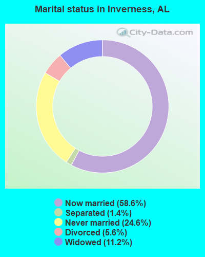
- Never married: 24.6%
- Now married: 58.6%
- Separated: 1.4%
- Widowed: 11.2%
- Divorced: 5.6%
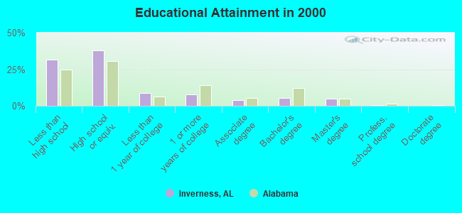
For population 25 years and over in Inverness:
- High school or higher: 68.5%
- Bachelor's degree or higher: 10.9%
- Graduate or professional degree: 5.6%
- Unemployed: 5.8%
- Mean travel time to work (commute): 26.6 minutes
| Here: | 13.6 |
| Alabama average: | 13.2 |
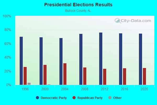
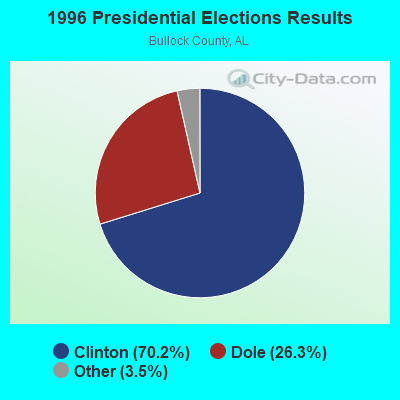
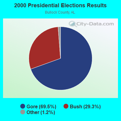
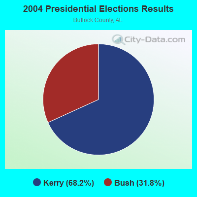
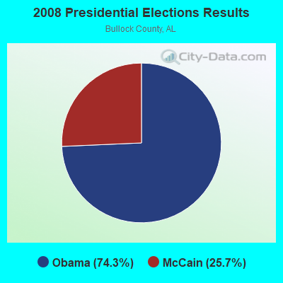
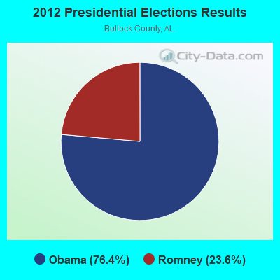
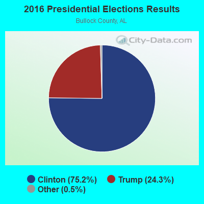
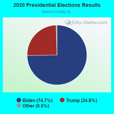
Graphs represent county-level data. Detailed 2008 Election Results
Religion statistics for Inverness, AL (based on Bullock County data)
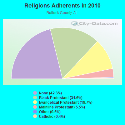
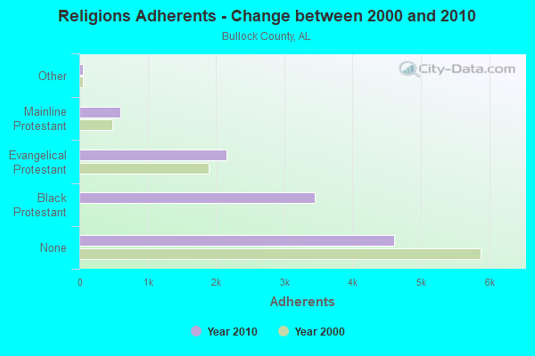
| Religion | Adherents | Congregations |
|---|---|---|
| Black Protestant | 3,445 | 21 |
| Evangelical Protestant | 2,152 | 15 |
| Mainline Protestant | 601 | 9 |
| Other | 53 | 1 |
| Catholic | 49 | 1 |
| None | 4,614 | - |
Food Environment Statistics:
| This county: | 1.83 / 10,000 pop. |
| Alabama: | 1.89 / 10,000 pop. |
| Bullock County: | 1.83 / 10,000 pop. |
| Alabama: | 6.32 / 10,000 pop. |
| Here: | 1.83 / 10,000 pop. |
| Alabama: | 5.75 / 10,000 pop. |
| Bullock County: | 14.5% |
| Alabama: | 11.8% |
| Bullock County: | 37.3% |
| Alabama: | 31.7% |
| Bullock County: | 15.6% |
| Alabama: | 13.5% |
Businesses in Inverness, AL
- Hyatt: 1
Strongest AM radio stations in Inverness:
- WTBF (970 AM; 5 kW; TROY, AL; Owner: TROY BROADCASTING CORP.)
- WMSP (740 AM; 10 kW; MONTGOMERY, AL; Owner: CUMULUS LICENSING CORP.)
- WQLS (1200 AM; 10 kW; OZARK, AL; Owner: STYLES BROADCASTING OF DOTHAN, INC.)
- WJOX (690 AM; 50 kW; BIRMINGHAM, AL; Owner: CITADEL BROADCASTING COMPANY)
- WACV (1170 AM; 10 kW; MONTGOMERY, AL; Owner: MONTGOMERY BROADCAST PROPERTIES, LTD)
- WNSI (810 AM; 50 kW; JACKSONVILLE, AL; Owner: UNITED BROADCASTING NETWORK, INC.)
- WGST (640 AM; 50 kW; ATLANTA, GA; Owner: CITICASTERS LICENSES, L.P.)
- WDJC (850 AM; 50 kW; BIRMINGHAM, AL; Owner: KIMTRON, INC.)
- WDAK (540 AM; 5 kW; COLUMBUS, GA; Owner: CLEAR CHANNEL BROADCASTING LICENSES, INC.)
- WKNG (1060 AM; daytime; 50 kW; TALLAPOOSA, GA; Owner: WKNG, INC.)
- WMAC (940 AM; 50 kW; MACON, GA; Owner: CUMULUS LICENSING CORP.)
- WAPI (1070 AM; 50 kW; BIRMINGHAM, AL; Owner: CITADEL BROADCASTING COMPANY)
- WASG (550 AM; 25 kW; ATMORE, AL; Owner: 550 AM, INC)
Strongest FM radio stations in Inverness:
- WQLD (104.3 FM; LUVERNE, AL; Owner: CAPSTAR TX LIMITED PARTNERSHIP)
- WZHT (105.7 FM; TROY, AL; Owner: CAPSTAR TX LIMITED PARTNERSHIP)
- WTSU (89.9 FM; MONTGOMERY-TROY, AL; Owner: TROY STATE UNIVERSITY)
- WLWI-FM (92.3 FM; MONTGOMERY, AL; Owner: CUMULUS LICENSING CORP.)
- WTBF-FM (94.7 FM; BRUNDIDGE, AL; Owner: TROY BROADCASTING CORPORATION)
- WAXU (91.1 FM; TROY, AL; Owner: AMERICAN FAMILY ASSOCIATION)
- WBAM-FM (98.9 FM; MONTGOMERY, AL; Owner: DEEP SOUTH BROADCASTING COMPANY)
- WHHY-FM (101.9 FM; MONTGOMERY, AL; Owner: CUMULUS LICENSING CORP.)
- WKMX (106.7 FM; ENTERPRISE, AL; Owner: WKMX, INC.)
- WMXS (103.3 FM; MONTGOMERY, AL; Owner: CUMULUS LICENSING CORP.)
TV broadcast stations around Inverness:
- WRJM-TV (Channel 67; TROY, AL; Owner: JOSIE PARK BROADCASTING, INC.)
- WSFA (Channel 12; MONTGOMERY, AL; Owner: LIBCO, INC.)
- WCOV-TV (Channel 20; MONTGOMERY, AL; Owner: WOODS COMMUNICATIONS CORPORATION)
- WNCF (Channel 32; MONTGOMERY, AL; Owner: CHANNEL 32 MONTGOMERY LLC)
- WGIQ (Channel 43; LOUISVILLE, AL; Owner: ALABAMA EDUCATIONAL TELEVISION COMMISSION)
- WDIQ (Channel 2; DOZIER, AL; Owner: ALABAMA EDUCATIONAL TELEVISION COMMISSION)
- WMCF-TV (Channel 45; MONTGOMERY, AL; Owner: TRINITY BROADCASTING NETWORK)
FCC Registered Antenna Towers:
15 (See the full list of FCC Registered Antenna Towers in Inverness)FCC Registered Private Land Mobile Towers:
4- S Highland And Lakes Dr (Lat: 33.390667 Lon: -86.665806), Type: Tower, Structure height: 20 m, Call Sign: WPFR923,
Assigned Frequencies: 859.287 MHz, 859.337 MHz, 859.362 MHz, 859.387 MHz, 860.287 MHz, 860.337 MHz, 860.362 MHz, 860.387 MHz, Grant Date: 07/30/2019, Expiration Date: 06/08/2029, Registrant: Southern Communications Services, Inc D/B/A Southern Linc, 600 18th St N Bin Sn-0800, Birmingham, AL 35203-2206, Phone: (205) 257-1534, Email:
- Lat: 33.426472 Lon: -86.687500, Call Sign: WPYB950,
Assigned Frequencies: 806.000 MHz, Grant Date: 08/16/2023, Expiration Date: 07/17/2033, Certifier: Ray Waters, Registrant: Southern Communications Services, Inc. D/B/A Southern Linc, 600 18th St N Bin Sn-0800, Birmingham, AL 35203-2206, Phone: (205) 257-1534, Email:
- S Highland And Lakes Dr (Lat: 33.390667 Lon: -86.665806), Type: Tower, Structure height: 20 m, Call Sign: WQJM798,
Assigned Frequencies: 855.162 MHz, 855.887 MHz, Grant Date: 04/28/2009, Expiration Date: 06/08/2019, Cancellation Date: 07/17/2014, Certifier: Robin J Cohen, Registrant: Sprint Nextel Corporation, 12502 Sunrise Valley Drive, Reston, VA 20191, Phone: (703) 433-4000, Fax: (703) 433-4483
- 3589 Cahaba Beach Rd (Lat: 33.426472 Lon: -86.687500), Type: Pole, Structure height: 45.7 m, Overall height: 46.6 m, Call Sign: WQJP298,
Assigned Frequencies: 855.162 MHz, 855.887 MHz, Grant Date: 07/02/2013, Expiration Date: 07/17/2023, Cancellation Date: 07/17/2014, Certifier: Robin J Cohen, Registrant: Sprint Nextel Corporation, 12502 Sunrise Valley Drive, Reston, VA 20191, Phone: (703) 433-4000, Fax: (703) 433-4483
FCC Registered Microwave Towers:
1- Oak Mountain, 5 Highland Lakes Drive (Lat: 33.390639 Lon: -86.665806), Type: Ltower, Structure height: 24.8 m, Call Sign: WNTF288,
Assigned Frequencies: 952.681 MHz, 928.681 MHz, 932.406 MHz, 941.406 MHz, 928.668 MHz, 952.668 MHz, Grant Date: 04/20/2010, Expiration Date: 06/29/2020, Cancellation Date: 05/17/2019, Registrant: Southern Company Services, 600 North 18th St/Bin 5n-8409, Birmingham, AL 35203, Phone: (205) 257-3223, Fax: (205) 257-2134, Email:
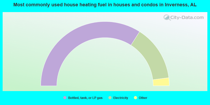
- 68.1%Bottled, tank, or LP gas
- 27.9%Electricity
- 2.9%Utility gas
- 1.1%Wood
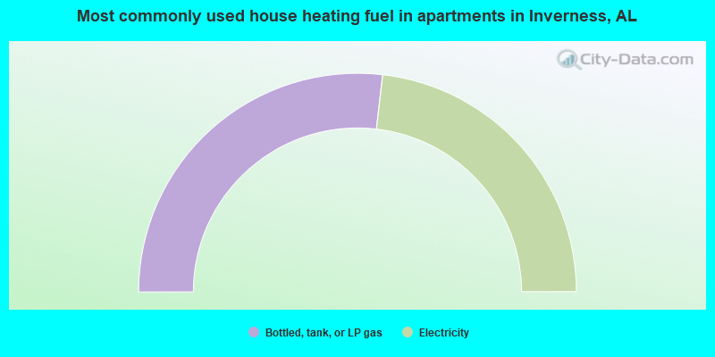
- 53.7%Bottled, tank, or LP gas
- 46.3%Electricity
Inverness compared to Alabama state average:
- Median house value below state average.
- Unemployed percentage below state average.
- Black race population percentage above state average.
- Hispanic race population percentage significantly below state average.
- Median age below state average.
- Foreign-born population percentage significantly below state average.
- Length of stay since moving in significantly above state average.
- Number of rooms per house significantly below state average.
- House age significantly below state average.
- Percentage of population with a bachelor's degree or higher below state average.