Jeromesville, Ohio
Submit your own pictures of this village and show them to the world
- OSM Map
- General Map
- Google Map
- MSN Map
Population change since 2000: +10.0%
 |
| Males: 219 | |
| Females: 307 |
| Median resident age: | 26.6 years |
| Ohio median age: | 39.9 years |
Zip codes: 44840.
| Jeromesville: | $72,761 |
| OH: | $65,720 |
Estimated per capita income in 2022: $29,821 (it was $16,864 in 2000)
Jeromesville village income, earnings, and wages data
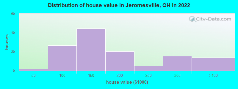
Estimated median house or condo value in 2022: $139,184 (it was $83,000 in 2000)
| Jeromesville: | $139,184 |
| OH: | $204,100 |
Mean prices in 2022: all housing units: $147,815; detached houses: $147,300
Median gross rent in 2022: $892.
(15.6% for White Non-Hispanic residents, 50.0% for American Indian residents)
Detailed information about poverty and poor residents in Jeromesville, OH
Compare current foreclosures near Jeromesville, OH:
| Photo | Address | Area | Beds / Baths | Price | Details |
|---|---|---|---|---|---|

|
#1
Canaan Center Rd.
Creston, OH 44217
|
2,160 sq. feet
|
1 baths 4 beds |
show details | |

|
#2
Monroe St
Nashville, OH 44661
|
1,530 sq. feet
|
2 baths 3 beds |
show details | |

|
#3
Patrick Pl
Wooster, OH 44691
|
1,732 sq. feet
|
2 baths 3 beds |
show details | |

|
#4
Mckinley St
Wooster, OH 44691
|
1,159 sq. feet
|
1 baths 3 beds |
show details | |

|
#5
Batdorf Rd
Wooster, OH 44691
|
1,134 sq. feet
|
2 baths 4 beds |
show details | |

|
#6
Vernon Rd
Mansfield, OH 44905
|
1,127 sq. feet
|
1 baths 2 beds |
show details | |

|
#7
Charvid Ave
Mansfield, OH 44905
|
1,988 sq. feet
|
1 baths 2 beds |
show details | |

|
#8
Batdorf Rd
Wooster, OH 44691
|
1,449 sq. feet
|
1 baths 3 beds |
show details | |

|
#9
N Main St
Ashland, OH 44805
|
1,752 sq. feet
|
1 baths 3 beds |
show details | |

|
#10
Emerick St
Wooster, OH 44691
|
1,456 sq. feet
|
2 baths 2 beds |
show details |
| Photo | Address | Area | Beds / Baths | Price | Details |
|---|---|---|---|---|---|

|
#11
N Main St
Ashland, OH 44805
|
1,752 sq. feet
|
1 baths 3 beds |
show details | |

|
#12
N Prospect St
Shreve, OH 44676
|
1,003 sq. feet
|
1 baths 3 beds |
show details | |

|
#13
Greenbriar Ln
Wooster, OH 44691
|
1,889 sq. feet
|
2 baths 3 beds |
show details | |

|
#14
Birdie Dr
West Salem, OH 44287
|
1,428 sq. feet
|
2 baths 3 beds |
show details | |

|
#15
1/2 Columbus Rd
Wooster, OH 44691
|
1,510 sq. feet
|
1 baths 3 beds |
show details | |

|
#16
Evergreen Ave W
Mansfield, OH 44905
|
1,776 sq. feet
|
1 baths 3 beds |
show details | |

|
#17
Mechanicsburg Rd
Wooster, OH 44691
|
1,056 sq. feet
|
2 baths 3 beds |
show details | |

|
#18
Derick St
Wooster, OH 44691
|
1,144 sq. feet
|
2 baths 3 beds |
show details | |

|
#19
Zachary Way
Mansfield, OH 44903
|
2,891 sq. feet
|
2 baths 3 beds |
show details | |

|
#20
Circle Dr W
Mansfield, OH 44905
|
1,516 sq. feet
|
1 baths 2 beds |
show details |
| Photo | Address | Area | Beds / Baths | Price | Details |
|---|---|---|---|---|---|

|
#21
E University St
Wooster, OH 44691
|
780 sq. feet
|
1 baths 2 beds |
show details | |

|
#22
Neil Cir N
Mansfield, OH 44903
|
1,386 sq. feet
|
2 baths 3 beds |
show details | |

|
#23
Dianewood Dr
Mansfield, OH 44903
|
2,108 sq. feet
|
2 baths 3 beds |
show details | |

|
#24
Graustark Path
Wooster, OH 44691
|
1,852 sq. feet
|
3 baths 4 beds |
show details | |

|
#25
Blair Blvd
Wooster, OH 44691
|
1,160 sq. feet
|
1 baths 3 beds |
show details | |

|
#26
Township Road 1451
Ashland, OH 44805
|
1,708 sq. feet
|
2 baths 3 beds |
show details | |

|
#27
Leiter Rd
Lucas, OH 44843
|
1,222 sq. feet
|
2 baths 3 beds |
show details | |

|
#28
Paradise View St
Mansfield, OH 44905
|
1,354 sq. feet
|
1 baths 3 beds |
show details | |

|
#29
N Union St
Loudonville, OH 44842
|
1,390 sq. feet
|
2 baths 3 beds |
show details | |

|
#30
Foster Path
Wooster, OH 44691
|
1,324 sq. feet
|
1 baths 3 beds |
show details |
| Photo | Address | Area | Beds / Baths | Price | Details |
|---|---|---|---|---|---|

|
#31
N Walnut St
Wooster, OH 44691
|
1,846 sq. feet
|
2 baths 3 beds |
show details | |

|
#32
Laver Rd
Mansfield, OH 44905
|
1,040 sq. feet
|
1 baths 3 beds |
show details | |

|
#33
Christmas Run Blvd
Wooster, OH 44691
|
1,548 sq. feet
|
2 baths 3 beds |
show details | |

|
#34
Emerick St
Wooster, OH 44691
|
858 sq. feet
|
1 baths 2 beds |
show details | |

|
#35
Armstrong Rd
Wooster, OH 44691
|
1,322 sq. feet
|
2 baths 3 beds |
show details | |

|
#36
Meadowbrook Dr
Wooster, OH 44691
|
1,300 sq. feet
|
2 baths 3 beds |
show details | |

|
#37
Unity Dr
Mansfield, OH 44905
|
960 sq. feet
|
1 baths 3 beds |
show details | |

|
#38
Gasche St
Wooster, OH 44691
|
1,672 sq. feet
|
1 baths 2 beds |
show details | |

|
#39
E 2nd St
Mansfield, OH 44902
|
1,312 sq. feet
|
1 baths 3 beds |
show details | |

|
#40
Schwartzwalder Rd
Shreve, OH 44676
|
996 sq. feet
|
1 baths 2 beds |
show details |
| Photo | Address | Area | Beds / Baths | Price | Details |
|---|---|---|---|---|---|

|
#41
E Walnut St
Ashland, OH 44805
|
1,308 sq. feet
|
1 baths 2 beds |
show details | |

|
#42
Samaritan Ave
Ashland, OH 44805
|
1,566 sq. feet
|
1 baths 3 beds |
show details | |

|
#43
Greenlee Rd
Mansfield, OH 44907
|
925 sq. feet
|
1 baths 3 beds |
show details | |

|
#44
Cleveland Ave
Ashland, OH 44805
|
1,144 sq. feet
|
1 baths 3 beds |
show details | |

|
#45
Manner Dr
Mansfield, OH 44905
|
1,114 sq. feet
|
1 baths 3 beds |
show details | |

|
#46
Sherman Ave
Ashland, OH 44805
|
929 sq. feet
|
1 baths 2 beds |
show details | |

|
#47
River Corners Rd
West Salem, OH 44287
|
1,910 sq. feet
|
2 baths 3 beds |
show details | |

|
#48
County Road 575
Nova, OH 44859
|
1,326 sq. feet
|
1 baths 4 beds |
show details | |

|
#49
Ashland Ave
Ashland, OH 44805
|
896 sq. feet
|
1 baths 3 beds |
show details | |

|
Check over 1 million property listings on Foreclosure.com!
|
browse all offers | |||


- 54685.3%White alone
- 619.5%Other race alone
- 335.2%Hispanic
- 50.8%Native Hawaiian and Other
Pacific Islander alone - 30.5%Two or more races
- 20.3%American Indian alone
Races in Jeromesville detailed stats: ancestries, foreign born residents, place of birth
According to our research of Ohio and other state lists, there were 6 registered sex offenders living in Jeromesville, Ohio as of May 15, 2024.
The ratio of all residents to sex offenders in Jeromesville is 97 to 1.
 Recent articles from our blog. Our writers, many of them Ph.D. graduates or candidates, create easy-to-read articles on a wide variety of topics.

 | Any opinions on Wooster area? (25 replies) |
| Moving to Mansfield, best places to live? (7 replies) |
| looking for small town in OH to make home (202 replies) |
Latest news from Jeromesville, OH collected exclusively by city-data.com from local newspapers, TV, and radio stations
Ancestries: German (26.3%), Irish (15.4%), American (12.7%), English (10.5%), European (5.7%), Scotch-Irish (3.1%).
Current Local Time: EST time zone
Elevation: 1012 feet
Land area: 0.36 square miles.
Population density: 1,441 people per square mile (low).
3 residents are foreign born
| This village: | 0.5% |
| Ohio: | 4.9% |
Median real estate property taxes paid for housing units with mortgages in 2022: $1,338 (0.9%)
Median real estate property taxes paid for housing units with no mortgage in 2022: $1,415 (1.1%)
Nearest city with pop. 50,000+: Elyria, OH  (39.7 miles , pop. 55,953).
Nearest city with pop. 200,000+: Akron, OH (40.0 miles , pop. 217,074).
Nearest city with pop. 1,000,000+: Chicago, IL (293.7 miles , pop. 2,896,016).
Nearest cities:
), ), ), )Latitude: 40.80 N, Longitude: 82.20 W
Area code commonly used in this area: 419
| Here: | 3.2% |
| Ohio: | 3.1% |
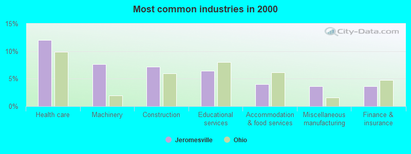
- Health care (12.0%)
- Machinery (7.6%)
- Construction (7.2%)
- Educational services (6.4%)
- Accommodation & food services (4.0%)
- Miscellaneous manufacturing (3.6%)
- Finance & insurance (3.6%)
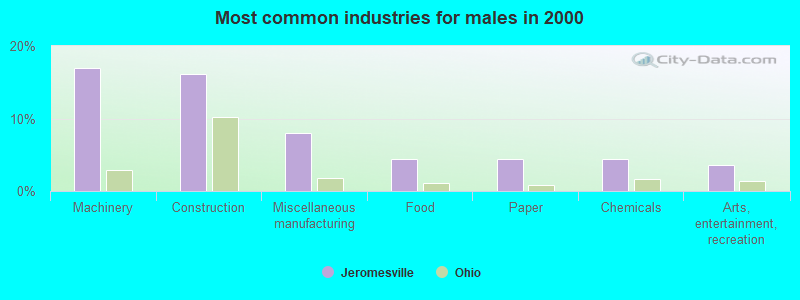
- Machinery (17.0%)
- Construction (16.1%)
- Miscellaneous manufacturing (8.0%)
- Food (4.5%)
- Paper (4.5%)
- Chemicals (4.5%)
- Arts, entertainment, recreation (3.6%)
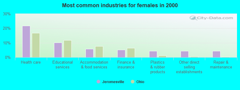
- Health care (21.7%)
- Educational services (10.1%)
- Accommodation & food services (5.8%)
- Finance & insurance (5.1%)
- Plastics & rubber products (4.3%)
- Other direct selling establishments (4.3%)
- Repair & maintenance (4.3%)
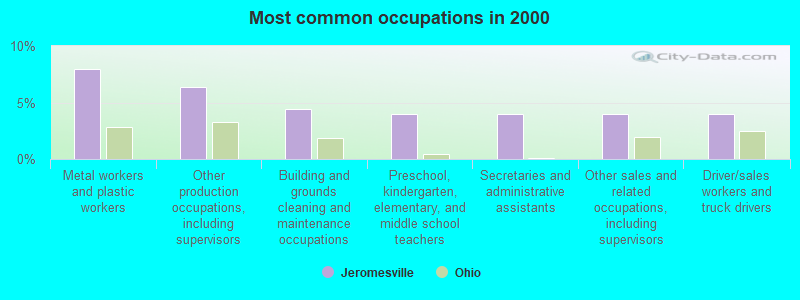
- Metal workers and plastic workers (8.0%)
- Other production occupations, including supervisors (6.4%)
- Building and grounds cleaning and maintenance occupations (4.4%)
- Preschool, kindergarten, elementary, and middle school teachers (4.0%)
- Secretaries and administrative assistants (4.0%)
- Other sales and related occupations, including supervisors (4.0%)
- Driver/sales workers and truck drivers (4.0%)
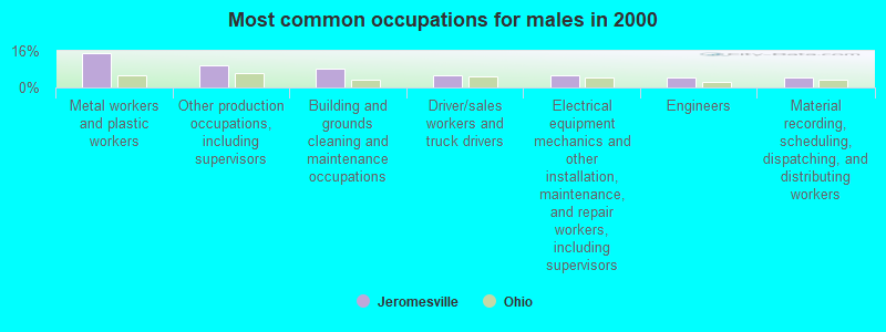
- Metal workers and plastic workers (15.2%)
- Other production occupations, including supervisors (9.8%)
- Building and grounds cleaning and maintenance occupations (8.0%)
- Driver/sales workers and truck drivers (5.4%)
- Electrical equipment mechanics and other installation, maintenance, and repair workers, including supervisors (5.4%)
- Engineers (4.5%)
- Material recording, scheduling, dispatching, and distributing workers (4.5%)

- Preschool, kindergarten, elementary, and middle school teachers (7.2%)
- Secretaries and administrative assistants (7.2%)
- Other sales and related occupations, including supervisors (7.2%)
- Registered nurses (5.1%)
- Health technologists and technicians (5.1%)
- Food and beverage serving workers, except waiters and waitresses (3.6%)
- Sales representatives, services, wholesale and manufacturing (3.6%)
Average climate in Jeromesville, Ohio
Based on data reported by over 4,000 weather stations


(lower is better)
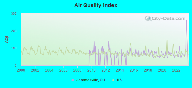
Air Quality Index (AQI) level in 2023 was 106. This is significantly worse than average.
| City: | 106 |
| U.S.: | 73 |
Ozone [ppb] level in 2022 was 33.7. This is about average. Closest monitor was 18.9 miles away from the city center.
| City: | 33.7 |
| U.S.: | 33.3 |
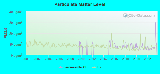
Particulate Matter (PM2.5) [µg/m3] level in 2023 was 10.7. This is worse than average. Closest monitor was 22.7 miles away from the city center.
| City: | 10.7 |
| U.S.: | 8.1 |
Tornado activity:
Jeromesville-area historical tornado activity is near Ohio state average. It is 21% greater than the overall U.S. average.
On 4/11/1965, a category F4 (max. wind speeds 207-260 mph) tornado 29.6 miles away from the Jeromesville village center killed 18 people and injured 200 people and caused between $5,000,000 and $50,000,000 in damages.
On 5/10/1973, a category F3 (max. wind speeds 158-206 mph) tornado 22.3 miles away from the village center killed 6 people and injured 100 people and caused between $500,000 and $5,000,000 in damages.
Earthquake activity:
Jeromesville-area historical earthquake activity is significantly above Ohio state average. It is 38% smaller than the overall U.S. average.On 9/25/1998 at 19:52:52, a magnitude 5.2 (4.8 MB, 4.3 MS, 5.2 LG, 4.5 MW, Depth: 3.1 mi, Class: Moderate, Intensity: VI - VII) earthquake occurred 105.1 miles away from the city center
On 1/31/1986 at 16:46:43, a magnitude 5.0 (5.0 MB) earthquake occurred 77.1 miles away from the city center
On 8/23/2011 at 17:51:04, a magnitude 5.8 (5.8 MW, Depth: 3.7 mi) earthquake occurred 303.2 miles away from Jeromesville center
On 7/27/1980 at 18:52:21, a magnitude 5.2 (5.1 MB, 4.7 MS, 5.0 UK, 5.2 UK) earthquake occurred 202.5 miles away from the city center
On 7/12/1986 at 08:19:37, a magnitude 4.5 (4.5 MB, Class: Light, Intensity: IV - V) earthquake occurred 115.6 miles away from the city center
On 6/10/2019 at 14:50:45, a magnitude 4.0 (4.0 MB, Depth: 1.2 mi) earthquake occurred 71.7 miles away from Jeromesville center
Magnitude types: regional Lg-wave magnitude (LG), body-wave magnitude (MB), surface-wave magnitude (MS), moment magnitude (MW)
Natural disasters:
The number of natural disasters in Ashland County (9) is smaller than the US average (15).Major Disasters (Presidential) Declared: 4
Emergencies Declared: 4
Causes of natural disasters: Storms: 3, Floods: 2, Snowstorms: 2, Tornadoes: 2, Blizzard: 1, Hurricane: 1, Mudslide: 1, Power Outage: 1, Tropical Depression: 1, Wind: 1, Winter Storm: 1, Other: 1 (Note: some incidents may be assigned to more than one category).
Hospitals and medical centers near Jeromesville:
- WINTERSONG VILLAGE OF HAYESVIL (Nursing Home, about 5 miles away; HAYESVILLE, OH)
- COUNTRY POINTE (Nursing Home, about 6 miles away; WOOSTER, OH)
- KINGSTON OF ASHLAND (Nursing Home, about 6 miles away; ASHLAND, OH)
- BRETHREN CARE INC (Nursing Home, about 7 miles away; ASHLAND, OH)
- CRYSTAL CARE CENTER OF ASHLAND (Nursing Home, about 7 miles away; ASHLAND, OH)
- SAMARITAN HOME CARE (Home Health Center, about 8 miles away; ASHLAND, OH)
- SAMARITAN REGIONAL HEALTH SYSTEM Acute Care Hospitals (about 8 miles away; ASHLAND, OH)
Colleges/universities with over 2000 students nearest to Jeromesville:
- Ashland University (about 8 miles; Ashland, OH; Full-time enrollment: 5,151)
- The College of Wooster (about 14 miles; Wooster, OH; FT enrollment: 2,112)
- Oberlin College (about 34 miles; Oberlin, OH; FT enrollment: 2,795)
- Stark State College (about 40 miles; North Canton, OH; FT enrollment: 7,707)
- Kent State University at Stark (about 40 miles; Canton, OH; FT enrollment: 3,259)
- University of Akron Main Campus (about 41 miles; Akron, OH; FT enrollment: 22,216)
- Malone University (about 43 miles; Canton, OH; FT enrollment: 2,201)
Public high school in Jeromesville:
- HILLSDALE HIGH SCHOOL (Students: 348, Location: 485 TOWNSHIP ROAD 1902, Grades: 9-12)
Public elementary/middle school in Jeromesville:
- HILLSDALE MIDDLE SCHOOL (Students: 313, Location: 144 N HIGH ST, Grades: 5-8)
Points of interest:
Notable location: Jeromesville Volunteer Fire Department (A). Display/hide its location on the map
Cemeteries: Methodist Cemetery (1), Jeromesville Cemetery (2). Display/hide their locations on the map
Drinking water stations with addresses in Jeromesville that have no violations reported:
- MOHICAN HILLS GOLF CLUB (Population served: 180, Primary Water Source Type: Groundwater)
| This village: | 2.7 people |
| Ohio: | 2.4 people |
| This village: | 74.0% |
| Whole state: | 65.0% |
| This village: | 7.2% |
| Whole state: | 6.8% |
Likely homosexual households (counted as self-reported same-sex unmarried-partner households)
- Lesbian couples: 0.0% of all households
- Gay men: 0.5% of all households
Banks with branches in Jeromesville (2011 data):
- PNC Bank, National Association: Jeromesville Branch at 31 West Main Street, branch established on 1954/04/01. Info updated 2012/03/20: Bank assets: $263,309.6 mil, Deposits: $197,343.0 mil, headquarters in Wilmington, DE, positive income, Commercial Lending Specialization, 3085 total offices, Holding Company: Pnc Financial Services Group, Inc., The
For population 15 years and over in Jeromesville:
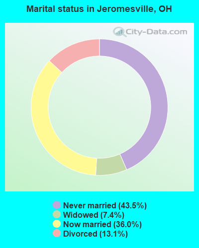
- Never married: 43.5%
- Now married: 36.0%
- Separated: 0.0%
- Widowed: 7.4%
- Divorced: 13.1%
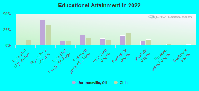
For population 25 years and over in Jeromesville:
- High school or higher: 98.6%
- Bachelor's degree or higher: 21.9%
- Graduate or professional degree: 6.8%
- Unemployed: 5.3%
- Mean travel time to work (commute): 19.8 minutes
| Here: | 7.6 |
| Ohio average: | 11.0 |
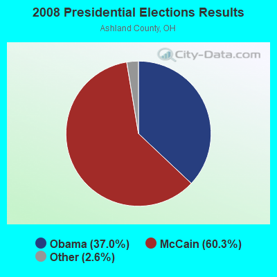


Graphs represent county-level data. Detailed 2008 Election Results
Religion statistics for Jeromesville, OH (based on Ashland County data)
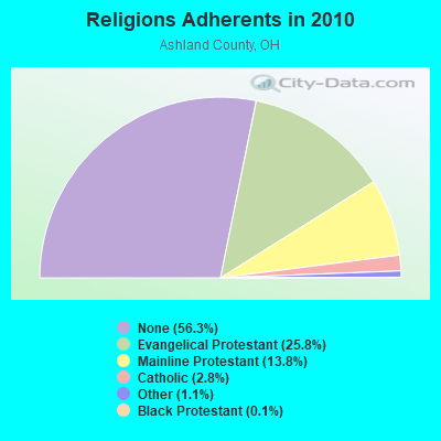
| Religion | Adherents | Congregations |
|---|---|---|
| Evangelical Protestant | 13,723 | 67 |
| Mainline Protestant | 7,318 | 36 |
| Catholic | 1,509 | 2 |
| Other | 568 | 3 |
| Black Protestant | 61 | 1 |
| Orthodox | 42 | 1 |
| None | 29,918 | - |
Food Environment Statistics:
| Ashland County: | 2.37 / 10,000 pop. |
| State: | 1.89 / 10,000 pop. |
| Ashland County: | 1.09 / 10,000 pop. |
| Ohio: | 1.25 / 10,000 pop. |
| Ashland County: | 3.10 / 10,000 pop. |
| Ohio: | 2.93 / 10,000 pop. |
| This county: | 5.11 / 10,000 pop. |
| Ohio: | 6.25 / 10,000 pop. |
| Ashland County: | 10.2% |
| Ohio: | 10.3% |
| Ashland County: | 28.7% |
| Ohio: | 29.1% |
| This county: | 11.9% |
| Ohio: | 11.9% |
Health and Nutrition:
| Jeromesville: | 49.5% |
| Ohio: | 50.4% |
| Jeromesville: | 49.2% |
| Ohio: | 47.8% |
| Here: | 28.8 |
| Ohio: | 28.7 |
| Here: | 24.2% |
| Ohio: | 20.6% |
| Here: | 8.4% |
| Ohio: | 10.4% |
| This city: | 6.9 |
| Ohio: | 6.8 |
| Jeromesville: | 33.0% |
| Ohio: | 34.3% |
| This city: | 54.4% |
| State: | 57.0% |
| This city: | 82.5% |
| Ohio: | 79.1% |
More about Health and Nutrition of Jeromesville, OH Residents
| Local government employment and payroll (March 2022) | |||||
| Function | Full-time employees | Monthly full-time payroll | Average yearly full-time wage | Part-time employees | Monthly part-time payroll |
|---|---|---|---|---|---|
| Financial Administration | 0 | $0 | 1 | $2,128 | |
| Streets and Highways | 0 | $0 | 1 | $1,777 | |
| Other Government Administration | 0 | $0 | 8 | $1,390 | |
| Totals for Government | 0 | $0 | 10 | $5,295 | |
Jeromesville government finances - Expenditure in 2017 (per resident):
- Current Operations - General - Other: $55,000 ($104.56)
Water Utilities: $15,000 ($28.52)
Sewerage: $15,000 ($28.52)
Central Staff Services: $11,000 ($20.91)
Financial Administration: $6,000 ($11.41)
Parks and Recreation: $6,000 ($11.41)
Judicial and Legal Services: $2,000 ($3.80)
- Total Salaries and Wages: $55,000 ($104.56)
- Water Utilities - Interest on Debt: $42,000 ($79.85)
Jeromesville government finances - Revenue in 2017 (per resident):
- Charges - Sewerage: $123,000 ($233.84)
- Miscellaneous - Interest Earnings: $6,000 ($11.41)
- Revenue - Water Utilities: $87,000 ($165.40)
- State Intergovernmental - Highways: $22,000 ($41.83)
General Local Government Support: $2,000 ($3.80)
- Tax - Property: $34,000 ($64.64)
Motor Vehicle License: $6,000 ($11.41)
Alcoholic Beverage License: $1,000 ($1.90)
Jeromesville government finances - Debt in 2017 (per resident):
- Long Term Debt - Beginning Outstanding - Unspecified Public Purpose: $1,032,000 ($1961.98)
Outstanding Unspecified Public Purpose: $1,032,000 ($1961.98)
Jeromesville government finances - Cash and Securities in 2017 (per resident):
- Sinking Funds - Cash and Securities: $465,000 ($884.03)
Strongest AM radio stations in Jeromesville:
- WKNR (850 AM; 50 kW; CLEVELAND, OH; Owner: CARON BROADCASTING, INC.)
- WTAM (1100 AM; 50 kW; CLEVELAND, OH; Owner: JACOR BROADCASTING CORPORATION)
- WHK (1220 AM; 50 kW; CLEVELAND, OH; Owner: CARON BROADCASTING, INC.)
- WNCO (1340 AM; 1 kW; ASHLAND, OH; Owner: CAPSTAR TX LIMITED PARTNERSHIP)
- WTVN (610 AM; 50 kW; COLUMBUS, OH; Owner: CITICASTERS LICENSES, L.P.)
- WWVA (1170 AM; 53 kW; WHEELING, WV; Owner: CAPSTAR TX LIMITED PARTNERSHIP)
- WHLO (640 AM; 5 kW; AKRON, OH; Owner: CLEAR CHANNEL BROADCASTING LICENSES, INC.)
- WJR (760 AM; 50 kW; DETROIT, MI; Owner: ABC, INC.)
- WHBC (1480 AM; 15 kW; CANTON, OH; Owner: NM LICENSING, LLC)
- WFDF (910 AM; 50 kW; FLINT, MI; Owner: ABC, INC.)
- WRFD (880 AM; daytime; 23 kW; COLUMBUS-WORTHINGTON, OH; Owner: SALEM MEDIA OF OHIO, INC.)
- WKVX (960 AM; 1 kW; WOOSTER, OH; Owner: WWST CORP., L.L.C.)
- WWMK (1260 AM; 10 kW; CLEVELAND, OH; Owner: ABC, INC.)
Strongest FM radio stations in Jeromesville:
- WNCO-FM (101.3 FM; ASHLAND, OH; Owner: CAPSTAR TX LIMITED PARTNERSHIP)
- WRDL (88.9 FM; ASHLAND, OH; Owner: ASHLAND UNIVERSITY)
- WOSV (91.7 FM; MANSFIELD, OH; Owner: THE OHIO STATE UNIVERSITY)
- WBZW (107.7 FM; LOUDONVILLE, OH; Owner: CAPSTAR TX LIMITED PARTNERSHIP)
- WKRW (89.3 FM; WOOSTER, OH; Owner: KENT STATE UNIVERSITY)
- WQKT (104.5 FM; WOOSTER, OH; Owner: WWST CORP., L.L.C.)
- WVNO-FM (106.1 FM; MANSFIELD, OH; Owner: JOHNNY APPLESEED BROADCASTING CO.)
- WWBK (98.3 FM; FREDERICKTOWN, OH; Owner: CAPSTAR TX LIMITED PARTNERSHIP)
- WKSU-FM (89.7 FM; KENT, OH; Owner: KENT STATE UNIVERSITY)
- WYHT (105.3 FM; MANSFIELD, OH; Owner: CAPSTAR TX LIMITED PARTNERSHIP)
- WQMX (94.9 FM; MEDINA, OH; Owner: RUBBER CITY RADIO GROUP, INC)
- WONE-FM (97.5 FM; AKRON, OH; Owner: RUBBER CITY RADIO GROUP, INC.)
- WZIP (88.1 FM; AKRON, OH; Owner: THE UNIVERSITY OF AKRON)
- WNWV (107.3 FM; ELYRIA, OH; Owner: ELYRIA-LORAIN BROADCASTING CO.)
- WCWS-FM (90.9 FM; WOOSTER, OH; Owner: THE COLLEGE OF WOOSTER)
- WQIO (93.7 FM; MOUNT VERNON, OH; Owner: CAPSTAR TX LIMITED PARTNERSHIP)
- WVMC-FM (90.7 FM; MANSFIELD, OH; Owner: MANSFIELD CHRISTIAN SCHOOL)
- WLRD (96.9 FM; WILLARD, OH; Owner: CHRISTIAN FAITH BROADCAST, INC.)
- W216AH (91.1 FM; ASHLAND, OH; Owner: MANSFIELD CHRISTIAN SCHOOL)
TV broadcast stations around Jeromesville:
- W33BW (Channel 33; ASHLAND, OH; Owner: CHRISTIAN FAITH BROADCAST, INC.)
- WMFD-TV (Channel 68; MANSFIELD, OH; Owner: MID-STATE TELEVISION,INC.)
- WEAO (Channel 49; AKRON, OH; Owner: NORTHEASTERN EDUCATIONAL TELEVISION OF OHIO, INC.)
- WVPX (Channel 23; AKRON, OH; Owner: PAXSON AKRON LICENSE, INC.)
- WOHZ-LP (Channel 57; MANSFIELD, OH; Owner: MID-STATE TELEVISION, INC.)
- W32AR (Channel 32; LEXINGTON, OH; Owner: TRINITY BROADCASTING NETWORK)
- National Bridge Inventory (NBI) Statistics
- 26Number of bridges
- 226ft / 69.2mTotal length
- 53,481Total average daily traffic
- 12,705Total average daily truck traffic
- 74,148Total future (year 2033) average daily traffic
- New bridges - historical statistics
- 11900-1909
- 51950-1959
- 81960-1969
- 11970-1979
- 31980-1989
- 41990-1999
- 22000-2009
- 12010-2019
- 12020-2022
FCC Registered Antenna Towers:
66 (See the full list of FCC Registered Antenna Towers in Jeromesville)FCC Registered Broadcast Land Mobile Towers:
5- 300 N Of Main St & 200 W Of Rt 89 (Lat: 40.804222 Lon: -82.197389), Call Sign: KQI230,
Assigned Frequencies: 154.070 MHz, Grant Date: 12/23/2022, Expiration Date: 01/26/2033, Registrant: Jeromesville Fire, 1 North Alley, Jeromesville, OH 44840, Phone: (419) 368-6811, Email:
- Lat: 40.779750 Lon: -82.216917, Call Sign: WQDR699,
Assigned Frequencies: 451.437 MHz, 456.437 MHz, Grant Date: 09/15/2015, Expiration Date: 10/14/2025, Certifier: Karla Fulk, Registrant: Staley Technologies, Inc, 1035 Front Ave., Sw, New Philadelphia, OH 44663, Phone: (330) 339-2898, Email:
- Lat: 40.846417 Lon: -82.154944, Call Sign: WQSJ819,
Assigned Frequencies: 159.930 MHz, 159.855 MHz, 159.900 MHz, Grant Date: 09/30/2013, Expiration Date: 09/30/2023, Cancellation Date: 12/02/2023, Certifier: Keith Hall, Registrant: New Wave Licensing Services Inc, 517 Sachs Road, Gettysburg, PA 17325, Phone: (717) 334-0910, Fax: (717) 334-4739, Email:
- TOWN HALL, South High Street (Lat: 40.803278 Lon: -82.195361), Type: Bant, Structure height: 10 m, Call Sign: WQVV925,
Assigned Frequencies: 458.356 MHz, Grant Date: 05/26/2015, Expiration Date: 05/26/2025, Certifier: David R Hazlett, Registrant: Federal Licensing Inc, 1588 Fairfield Road, Gettysburg, PA 17325, Phone: (717) 334-9262, Fax: (717) 334-6440
- Lat: 40.784083 Lon: -82.210889, Call Sign: WRPB966,
Assigned Frequencies: 467.212 MHz, Grant Date: 01/14/2022, Expiration Date: 01/14/2032, Certifier: Steven E Dickerson, Registrant: Innovation Wireless, 11869 Teale St, Culver City, CA 90230, Phone: (888) 559-5565, Email:
FCC Registered Microwave Towers:
7- CL393 TUGEND, 588 County Road 30a (Lat: 40.784222 Lon: -82.231667), Type: Ltower, Structure height: 86.3 m, Overall height: 87.8 m, Call Sign: WPWR498,
Assigned Frequencies: 6256.54 MHz, 6197.24 MHz, 6345.49 MHz, Grant Date: 12/04/2012, Expiration Date: 01/09/2023, Cancellation Date: 03/19/2019, Certifier: Carol L Tacker, Registrant: At&t Mobility LLC, 208 S Akard St., Rm 1015, Dallas, TX 75202, Phone: (855) 699-7073, Fax: (214) 746-6410, Email:
- CL410 MARTIN, 478 County Road 1302 (Lat: 40.871111 Lon: -82.221611), Type: Ltower, Structure height: 85.3 m, Overall height: 86.9 m, Call Sign: WPWR512,
Assigned Frequencies: 6093.45 MHz, Grant Date: 12/04/2012, Expiration Date: 01/09/2023, Cancellation Date: 03/19/2019, Certifier: Carol L Tacker, Registrant: At&t Mobility LLC, 208 S Akard St., Rm 1015, Dallas, TX 75202, Phone: (855) 699-7073, Fax: (214) 746-6410, Email:
- AT51297, 2142 Sr. 89 (Mohicanville #51297) (Lat: 40.749111 Lon: -82.191222), Type: Ltower, Structure height: 76.5 m, Overall height: 79.2 m, Call Sign: WQQS352,
Assigned Frequencies: 6034.15 MHz, 6093.45 MHz, Grant Date: 02/21/2013, Expiration Date: 02/21/2023, Cancellation Date: 05/12/2016, Certifier: Brian Higgins, Registrant: Eg Broadcast Newco Corp, 1209 Orange St, Wilmington, DE 19801, Phone: (212) 464-2568, Email:
- JEROME FORK, 36 Country Road 1975 (Lat: 40.783639 Lon: -82.136083), Type: Ltower, Structure height: 86.3 m, Overall height: 89 m, Call Sign: WQTN273,
Assigned Frequencies: 10775.0 MHz, 10815.0 MHz, 10855.0 MHz, 10895.0 MHz, 10815.0 MHz, Grant Date: 02/06/2024, Expiration Date: 03/10/2034, Certifier: John Monday, Registrant: At&t Services, Inc., 208 S Akard St, 20f, Dallas, TX 75202, Phone: (855) 699-7073, Email:
- TUGEND, 1974 County Road 2175 (Lat: 40.775472 Lon: -82.221333), Type: Ltower, Structure height: 76.2 m, Overall height: 79.2 m, Call Sign: WQVL428,
Assigned Frequencies: 10795.0 MHz, Grant Date: 03/18/2015, Expiration Date: 03/18/2025, Cancellation Date: 12/06/2023, Certifier: Gregory M Romano, Registrant: Verizon, 5055 Northpointe Pkwy, Alpharetta, GA 30022, Phone: (770) 797-1070, Email:
- MOHICANVILLE, 2142 Sr. 89 (Mohicanville #51297) (Lat: 40.749111 Lon: -82.191222), Type: Gtower, Structure height: 76.5 m, Overall height: 79.2 m, Call Sign: WQVL429,
Assigned Frequencies: 11285.0 MHz, Grant Date: 03/18/2015, Expiration Date: 03/18/2025, Cancellation Date: 12/06/2023, Certifier: Gregory M Romano, Registrant: Verizon, 5055 Northpointe Pkwy, Alpharetta, GA 30022, Phone: (770) 797-1070, Email:
- OH100A, 2142 Sr. 89 (Mohicanville #51297) (Lat: 40.749111 Lon: -82.191222), Type: Ltower, Structure height: 76.5 m, Overall height: 79.2 m, Call Sign: WQZV740,
Assigned Frequencies: 11385.0 MHz, 11425.0 MHz, 11385.0 MHz, 11425.0 MHz, 11385.0 MHz, 11425.0 MHz, 11385.0 MHz, 11425.0 MHz, 11385.0 MHz, 11425.0 MHz, 11385.0 MHz, 11425.0 MHz, Grant Date: 08/15/2017, Expiration Date: 08/15/2027, Certifier: Richard C Rowlenson, Registrant: Micronet Communications, Inc., 812 Lexington Dr, Plano, TX 75075, Phone: (972) 422-7200, Email:
FCC Registered Amateur Radio Licenses:
12 (See the full list of FCC Registered Amateur Radio Licenses in Jeromesville)FAA Registered Aircraft:
2- Aircraft: PIPER PA-32-300 (Category: Land, Seats: 6, Weight: Up to 12,499 Pounds, Speed: 126 mph), Engine: LYCOMING TI0-540 SER (310 HP) (Reciprocating)
N-Number: 4468X, N4468X, N-4468X, Serial Number: 32-7640024, Year manufactured: 1975, Airworthiness Date: 10/14/1975, Certificate Issue Date: 07/17/2015
Registrant (Co-Owned): Michael W Schweyer, 2040 State Route 89 Apt G, Jeromesville, OH 44840, Other Owners: Angela M Schweyer - Aircraft: CESSNA 172N (Category: Land, Seats: 4, Weight: Up to 12,499 Pounds, Speed: 105 mph), Engine: LYCOMING 0-320 SERIES (180 HP) (Reciprocating)
N-Number: 5652E, N5652E, N-5652E, Serial Number: 17271912, Year manufactured: 1978, Airworthiness Date: 12/06/1978, Certificate Issue Date: 09/15/2008
Registrant (LLC): N5652e LLC, 348 County Road 2000, Jeromesville, OH 44840
2002 - 2018 National Fire Incident Reporting System (NFIRS) incidents
- Fire incident types reported to NFIRS in Jeromesville, OH
- 9846.4%Structure Fires
- 8238.9%Outside Fires
- 3014.2%Mobile Property/Vehicle Fires
- 10.5%Other
 Based on the data from the years 2002 - 2018 the average number of fire incidents per year is 12. The highest number of reported fires - 24 took place in 2014, and the least - 3 in 2004. The data has a rising trend.
 When looking into fire subcategories, the most reports belonged to: Structure Fires (46.4%), and Outside Fires (38.9%).
| Most common first names in Jeromesville, OH among deceased individuals | ||
| Name | Count | Lived (average) |
|---|---|---|
| William | 16 | 79.9 years |
| John | 15 | 77.0 years |
| James | 14 | 73.6 years |
| Dorothy | 11 | 76.6 years |
| Ruth | 11 | 83.4 years |
| Robert | 10 | 74.6 years |
| Donald | 9 | 69.7 years |
| Ralph | 8 | 73.4 years |
| Charles | 7 | 79.3 years |
| Mary | 7 | 78.3 years |
| Most common last names in Jeromesville, OH among deceased individuals | ||
| Last name | Count | Lived (average) |
|---|---|---|
| Smith | 15 | 71.9 years |
| Jones | 7 | 84.8 years |
| Sours | 7 | 71.7 years |
| Funk | 7 | 85.1 years |
| Austen | 6 | 70.5 years |
| Eagle | 6 | 74.7 years |
| Donelson | 5 | 80.2 years |
| Dague | 5 | 67.4 years |
| Austin | 5 | 79.2 years |
| Sellers | 5 | 70.4 years |
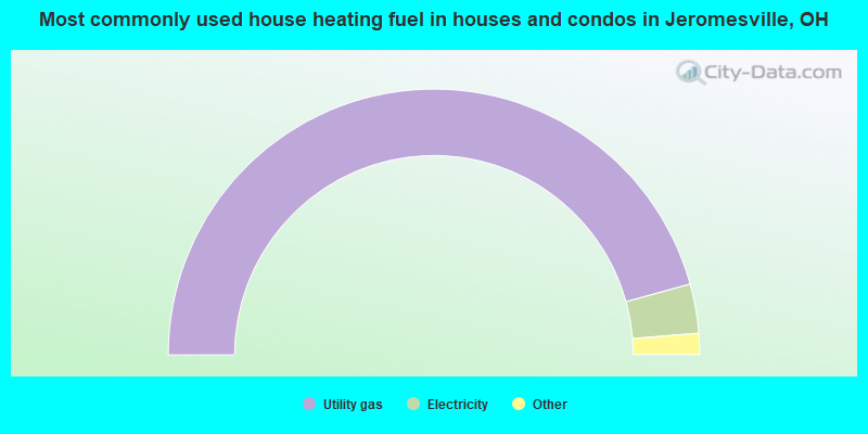
- 91.8%Utility gas
- 6.0%Electricity
- 1.5%Coal or coke
- 0.7%Wood
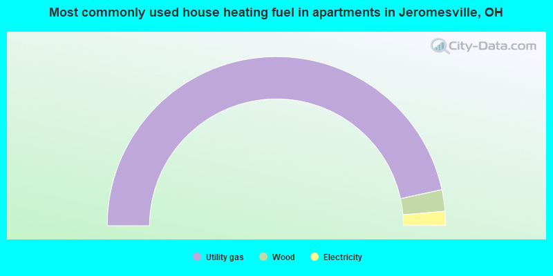
- 93.2%Utility gas
- 4.1%Wood
- 2.7%Electricity
Jeromesville compared to Ohio state average:
- Unemployed percentage below state average.
- Black race population percentage significantly below state average.
- Median age below state average.
- Foreign-born population percentage significantly below state average.
- Length of stay since moving in significantly above state average.
- House age above state average.
Jeromesville on our top lists:
- #1 on the list of "Top 101 cities with the most residents born in Other Northern America (population 500+)"
- #39 on the list of "Top 101 counties with the largest number of people moving out compared to moving in (pop. 50,000+)"
- #62 on the list of "Top 101 counties with the largest number of people without health insurance coverage in 2000 (pop. 50,000+)"
- #63 on the list of "Top 101 counties with the largest increase in the number of deaths per 1000 residents 2000-2006 to 2007-2013 (pop. 50,000+)"
- #80 on the list of "Top 101 counties with the lowest total withdrawal of fresh water for public supply (pop. 50,000+)"

|
Total of 8 patent applications in 2008-2024.