Jones Chapel, Alabama
Submit your own pictures of this place and show them to the world
- OSM Map
- General Map
- Google Map
- MSN Map

| Males: 2,303 | |
| Females: 2,286 |
| Median resident age: | 35.5 years |
| Alabama median age: | 35.8 years |
Zip code: 35057
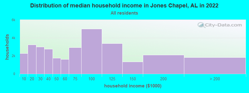
| Jones Chapel: | $54,957 |
| AL: | $59,674 |
Estimated per capita income in 2022: $25,645 (it was $13,482 in 2000)
Jones Chapel CCD income, earnings, and wages data
Estimated median house or condo value in 2022: $157,361 (it was $67,100 in 2000)
| Jones Chapel: | $157,361 |
| AL: | $200,900 |
Mean prices in 2022: all housing units: $206,968; detached houses: $237,907; townhouses or other attached units: $214,311; in 2-unit structures: $134,611; in 5-or-more-unit structures: $302,652; mobile homes: $75,346; occupied boats, rvs, vans, etc.: $99,714
Detailed information about poverty and poor residents in Jones Chapel, AL


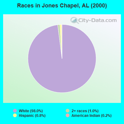
- 4,32798.0%White alone
- 441.0%Two or more races
- 340.8%Hispanic
- 100.2%American Indian alone
- 10.02%Asian alone
- 10.02%Native Hawaiian and Other
Pacific Islander alone
 Recent articles from our blog. Our writers, many of them Ph.D. graduates or candidates, create easy-to-read articles on a wide variety of topics.
Current Local Time: CST time zone
Elevation: 978 feet
Land area: 83.8 square miles.
Population density: 55 people per square mile (very low).

| Jones Chapel CCD: | 0.3% ($199) |
| Alabama: | 0.4% ($289) |
Nearest city with pop. 50,000+: Decatur, AL  (25.5 miles , pop. 53,929).
Nearest city with pop. 200,000+: Birmingham, AL (49.9 miles , pop. 242,820).
Nearest city with pop. 1,000,000+: Chicago, IL (528.4 miles , pop. 2,896,016).
Nearest cities:
), ), ), ), ), )Latitude: 34.22 N, Longitude: 87.06 W

| Here: | 2.1% |
| Alabama: | 2.6% |
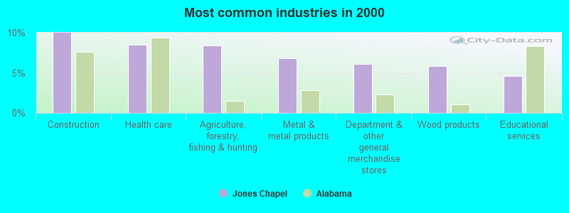
- Construction (10.0%)
- Health care (8.5%)
- Agriculture, forestry, fishing & hunting (8.4%)
- Metal & metal products (6.8%)
- Department & other general merchandise stores (6.1%)
- Wood products (5.9%)
- Educational services (4.6%)
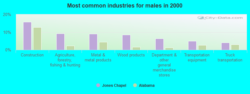
- Construction (15.8%)
- Agriculture, forestry, fishing & hunting (9.2%)
- Metal & metal products (9.0%)
- Wood products (8.6%)
- Department & other general merchandise stores (6.4%)
- Transportation equipment (4.9%)
- Truck transportation (4.1%)
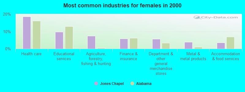
- Health care (18.7%)
- Educational services (9.7%)
- Agriculture, forestry, fishing & hunting (7.5%)
- Finance & insurance (5.8%)
- Department & other general merchandise stores (5.7%)
- Metal & metal products (4.0%)
- Accommodation & food services (3.6%)
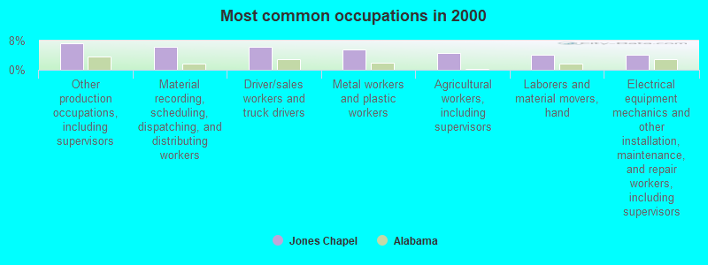
- Other production occupations, including supervisors (7.3%)
- Material recording, scheduling, dispatching, and distributing workers (6.3%)
- Driver/sales workers and truck drivers (6.2%)
- Metal workers and plastic workers (5.7%)
- Agricultural workers, including supervisors (4.7%)
- Laborers and material movers, hand (4.2%)
- Electrical equipment mechanics and other installation, maintenance, and repair workers, including supervisors (4.1%)

- Driver/sales workers and truck drivers (11.1%)
- Metal workers and plastic workers (7.8%)
- Other production occupations, including supervisors (7.5%)
- Electrical equipment mechanics and other installation, maintenance, and repair workers, including supervisors (7.4%)
- Material recording, scheduling, dispatching, and distributing workers (5.2%)
- Agricultural workers, including supervisors (4.6%)
- Other management occupations, except farmers and farm managers (4.5%)
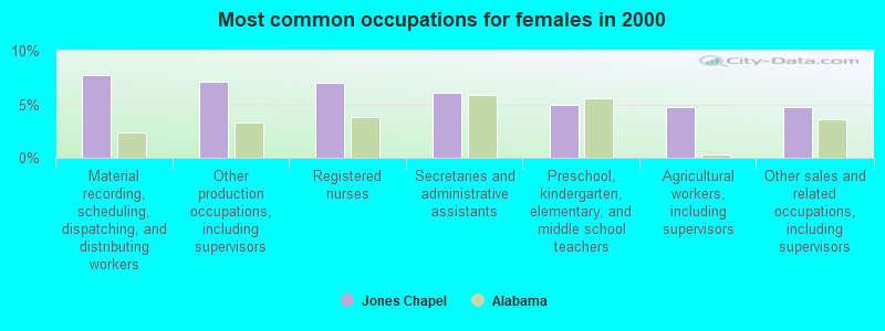
- Material recording, scheduling, dispatching, and distributing workers (7.7%)
- Other production occupations, including supervisors (7.1%)
- Registered nurses (7.0%)
- Secretaries and administrative assistants (6.1%)
- Preschool, kindergarten, elementary, and middle school teachers (4.9%)
- Agricultural workers, including supervisors (4.8%)
- Other sales and related occupations, including supervisors (4.8%)
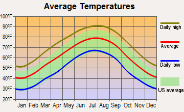
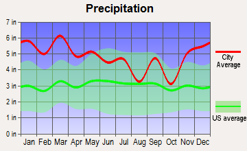
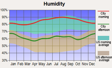
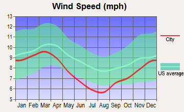
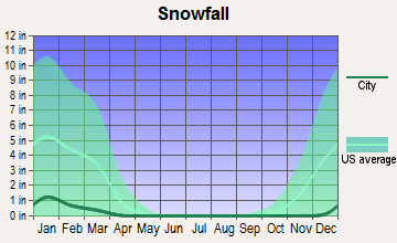
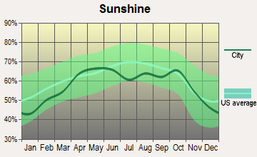
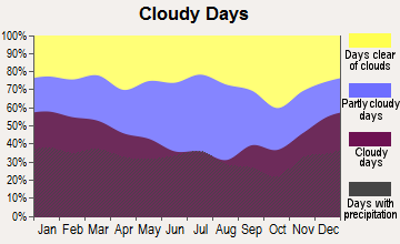
Average climate in Jones Chapel, Alabama
Based on data reported by over 4,000 weather stations
(lower is better)
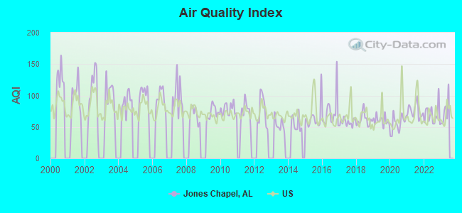
Air Quality Index (AQI) level in 2022 was 69.3. This is about average.
| City: | 69.3 |
| U.S.: | 72.6 |
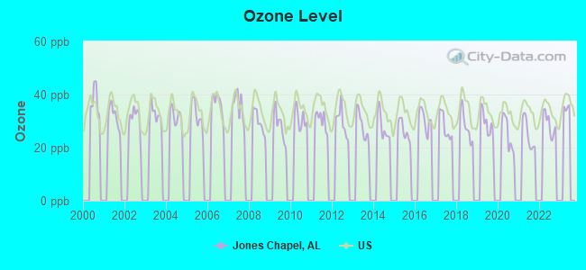
Ozone [ppb] level in 2022 was 28.9. This is about average. Closest monitor was 22.3 miles away from the city center.
| City: | 28.9 |
| U.S.: | 33.3 |
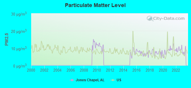
Particulate Matter (PM2.5) [µg/m3] level in 2022 was 9.10. This is about average. Closest monitor was 22.3 miles away from the city center.
| City: | 9.10 |
| U.S.: | 8.11 |
Tornado activity:
Jones Chapel-area historical tornado activity is slightly above Alabama state average. It is 175% greater than the overall U.S. average.
On 4/3/1974, a category F5 (max. wind speeds 261-318 mph) tornado 19.8 miles away from the Jones Chapel place center killed 28 people and injured 272 people.
On 4/24/1955, a category F4 (max. wind speeds 207-260 mph) tornado 9.2 miles away from the place center killed 5 people and injured 20 people and caused between $500,000 and $5,000,000 in damages.
Earthquake activity:
Jones Chapel-area historical earthquake activity is significantly above Alabama state average. It is 167% greater than the overall U.S. average.On 1/18/1999 at 07:00:53, a magnitude 4.8 (4.8 MB, 4.0 LG, Depth: 0.6 mi, Class: Light, Intensity: IV - V) earthquake occurred 57.3 miles away from the city center
On 4/29/2003 at 08:59:39, a magnitude 4.9 (4.4 MB, 4.6 MW, 4.9 LG) earthquake occurred 83.7 miles away from Jones Chapel center
On 6/24/1975 at 11:11:36, a magnitude 4.5 (4.5 MB) earthquake occurred 56.7 miles away from the city center
On 4/29/2003 at 08:59:39, a magnitude 4.6 (4.6 MW, Depth: 12.3 mi) earthquake occurred 83.6 miles away from the city center
On 3/25/1976 at 00:41:20, a magnitude 5.0 (4.9 MB, 5.0 LG, Class: Moderate, Intensity: VI - VII) earthquake occurred 209.9 miles away from the city center
On 4/18/2008 at 09:36:59, a magnitude 5.4 (5.1 MB, 4.8 MS, 5.4 MW, 5.2 MW) earthquake occurred 296.5 miles away from the city center
Magnitude types: regional Lg-wave magnitude (LG), body-wave magnitude (MB), surface-wave magnitude (MS), moment magnitude (MW)
Natural disasters:
The number of natural disasters in Cullman County (28) is a lot greater than the US average (15).Major Disasters (Presidential) Declared: 19
Emergencies Declared: 5
Causes of natural disasters: Storms: 17, Floods: 13, Tornadoes: 12, Hurricanes: 5, Winds: 4, Freezes: 2, Winter Storms: 2, Drought: 1, Ice Storm: 1, Snowfall: 1, Other: 1 (Note: some incidents may be assigned to more than one category).
Hospitals and medical centers near Jones Chapel:
- CULLMAN COUNTY HOME CARE (Home Health Center, about 12 miles away; CULLMAN, AL)
- CULLMAN HEALTH CARE CENTER (Nursing Home, about 13 miles away; CULLMAN, AL)
- HOSPICE OF CULLMAN COUNTY (Hospital, about 13 miles away; CULLMAN, AL)
- DCI CULLMAN (Dialysis Facility, about 13 miles away; CULLMAN, AL)
- CULLMAN OUTPATIENT SERVICES LTD (Hospital, about 13 miles away; CULLMAN, AL)
- WOODLAND VILLAGE HEALTH CARE CENTER (Nursing Home, about 13 miles away; CULLMAN, AL)
- FALKVILLE HEALTH CARE CENTER (Nursing Home, about 14 miles away; FALKVILLE, AL)
Colleges/universities with over 2000 students nearest to Jones Chapel:
- George C Wallace State Community College-Hanceville (about 19 miles; Hanceville, AL; Full-time enrollment: 4,486)
- Bevill State Community College (about 29 miles; Jasper, AL; FT enrollment: 2,970)
- John C Calhoun State Community College (about 31 miles; Tanner, AL; FT enrollment: 7,911)
- Athens State University (about 42 miles; Athens, AL; FT enrollment: 2,771)
- University of Alabama in Huntsville (about 43 miles; Huntsville, AL; FT enrollment: 6,006)
- Jefferson State Community College (about 44 miles; Birmingham, AL; FT enrollment: 6,041)
- Alabama A & M University (about 49 miles; Normal, AL; FT enrollment: 4,524)
Points of interest:
Notable locations in Jones Chapel: Battleground Volunteer Fire Department Station 1 (A), Jones Chapel Volunteer Fire Department Station 1 (B), Jones Chapel Volunteer Fire Department Station 2 (C), Battleground Volunteer Fire Department Station 2 (D). Display/hide their locations on the map
Churches in Jones Chapel include: Antioch Church (A), Peoples Church (B), Oak Grove Church of God (C), Neighborhood Baptist Church (D), Jones Chapel Church of Christ (E), Jones Chapel Church (F), Corinth West Methodist Church (G), Corinth Baptist Church (H), Chances Crossroad Church of Christ (I). Display/hide their locations on the map
Cemeteries: Lebanon Cemetery (1), Jones Chapel Cemetery (2), Corinth Cemetery (3), New Hope Cemetery (4), Mount Olive Cemetery (5), New Mount Zion Cemetery (6), Blair Cemetery (7). Display/hide their locations on the map
Reservoir: Harbisons Pond (A). Display/hide its location on the map
Streams, rivers, and creeks: Jaybird Creek (A), Jones Creek (B), Kid Branch (C), Lewis Branch (D), Ragland Branch (E), Sullivan Creek (F), Tarkiln Branch (G), Whetstone Creek (H), Stable Branch (I). Display/hide their locations on the map
| This place: | 2.6 people |
| Alabama: | 2.5 people |
| This place: | 73.8% |
| Whole state: | 67.8% |
| This place: | 5.0% |
| Whole state: | 4.7% |
Likely homosexual households (counted as self-reported same-sex unmarried-partner households)
- Lesbian couples: 0.2% of all households
- Gay men: 0.4% of all households
| This place: | 20.7% |
| Whole state: | 16.1% |
| This place: | 5.2% |
| Whole state: | 7.3% |
For population 15 years and over in Jones Chapel:
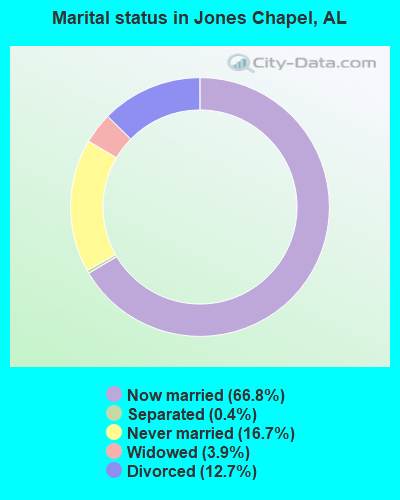
- Never married: 16.7%
- Now married: 66.8%
- Separated: 0.4%
- Widowed: 3.9%
- Divorced: 12.7%
For population 25 years and over in Jones Chapel:
- High school or higher: 67.3%
- Bachelor's degree or higher: 6.5%
- Graduate or professional degree: 2.9%
- Unemployed: 3.7%
- Mean travel time to work (commute): 34.2 minutes
| Here: | 13.2 |
| Alabama average: | 13.2 |
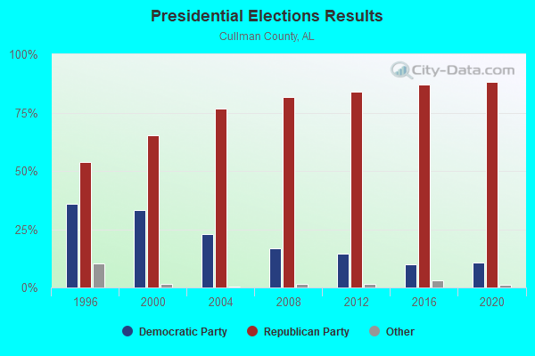
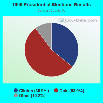
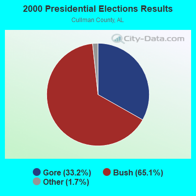
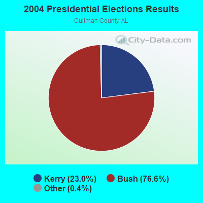
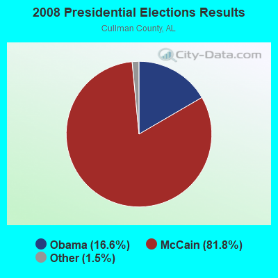
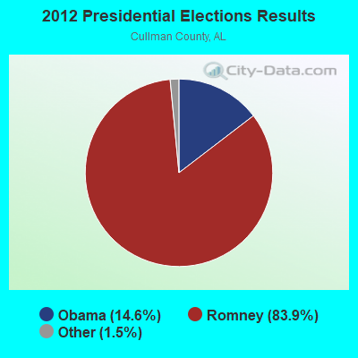
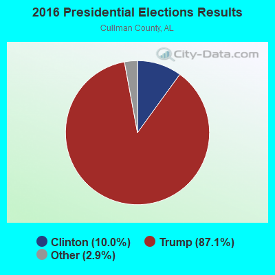
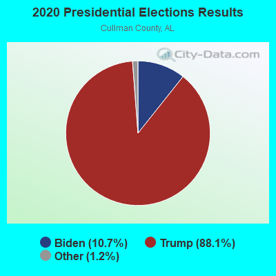
Graphs represent county-level data. Detailed 2008 Election Results
Religion statistics for Jones Chapel, AL (based on Cullman County data)
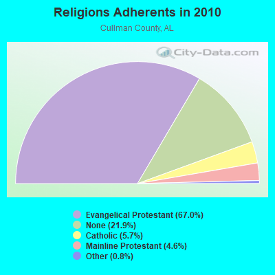
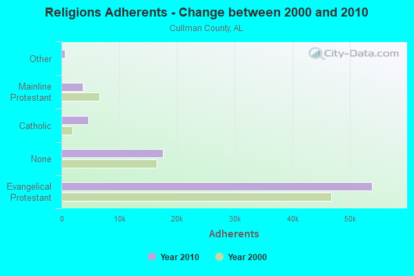
| Religion | Adherents | Congregations |
|---|---|---|
| Evangelical Protestant | 53,863 | 199 |
| Catholic | 4,614 | 2 |
| Mainline Protestant | 3,698 | 24 |
| Other | 624 | 2 |
| None | 17,607 | - |
Food Environment Statistics:
| This county: | 1.24 / 10,000 pop. |
| State: | 1.89 / 10,000 pop. |
| Cullman County: | 0.12 / 10,000 pop. |
| Alabama: | 0.20 / 10,000 pop. |
| Cullman County: | 0.25 / 10,000 pop. |
| Alabama: | 0.65 / 10,000 pop. |
| Cullman County: | 6.84 / 10,000 pop. |
| State: | 6.32 / 10,000 pop. |
| This county: | 6.59 / 10,000 pop. |
| State: | 5.75 / 10,000 pop. |
| Cullman County: | 10.7% |
| Alabama: | 11.8% |
| Cullman County: | 29.4% |
| Alabama: | 31.7% |
| Here: | 16.7% |
| Alabama: | 13.5% |
Strongest AM radio stations in Jones Chapel:
- WDJC (850 AM; 50 kW; BIRMINGHAM, AL; Owner: KIMTRON, INC.)
- WMCJ (1460 AM; 5 kW; CULLMAN, AL)
- WJOX (690 AM; 50 kW; BIRMINGHAM, AL; Owner: CITADEL BROADCASTING COMPANY)
- WAPI (1070 AM; 50 kW; BIRMINGHAM, AL; Owner: CITADEL BROADCASTING COMPANY)
- WLOR (1550 AM; 50 kW; HUNTSVILLE, AL; Owner: BCA RADIO, LLC)
- WNSI (810 AM; 50 kW; JACKSONVILLE, AL; Owner: UNITED BROADCASTING NETWORK, INC.)
- WVNN (770 AM; 10 kW; ATHENS, AL; Owner: ATHENS BROADCASTING COMPANY, INC.)
- WFMH (1340 AM; 1 kW; CULLMAN, AL; Owner: VOICE OF CULLMAN, L.L.C.)
- WWAM (820 AM; daytime; 50 kW; JASPER, TN; Owner: SHELTON BROADCASTING SYSTEM)
- WCOC (1010 AM; 5 kW; DORA, AL; Owner: AZTECA COMMUNICATIONS OF ALABAMA, INC.)
- WDJL (1000 AM; daytime; 10 kW; HUNTSVILLE, AL; Owner: JAMES K. SHARP DBA 5TH AVE BROADCASTING)
- WSM (650 AM; 50 kW; NASHVILLE, TN; Owner: GAYLORD ENTERTAINMENT COMPANY)
- WYAM (890 AM; daytime; 2 kW; HARTSELLE, AL; Owner: DECATUR COMMUNICATIONS PROPERTIES, LLC)
Strongest FM radio stations in Jones Chapel:
- WYDE-FM (101.1 FM; CULLMAN, AL; Owner: KIMTRON, INC.)
- WQAH-FM (105.7 FM; ADDISON, AL; Owner: ALVIN ABERCROMBIE)
- WTAK-FM (106.1 FM; HARTSELLE, AL; Owner: CAPSTAR TX LIMITED PARTNERSHIP)
- WEUP-FM (103.1 FM; MOULTON, AL; Owner: HUNDLEY BATES, SR. AND VIRGINIA CAPLES)
- WRSA-FM (96.9 FM; DECATUR, AL; Owner: NCA, INC.)
- WDXB (102.5 FM; JASPER, AL; Owner: CAPSTAR TX LIMITED PARTNERSHIP)
- WAHR (99.1 FM; HUNTSVILLE, AL; Owner: BCA RADIO, LLC)
- WRAX (107.7 FM; BIRMINGHAM, AL; Owner: CITADEL BROADCASTING COMPANY)
- W289AC (105.7 FM; HUNTSVILLE, AL; Owner: WILLIAM PAXTON ROGERS)
- WZYP (104.3 FM; ATHENS, AL; Owner: ATHENS BROADCASTING COMPANY, INC.)
- WXQW (94.1 FM; MERIDIANVILLE, AL; Owner: CAPSTAR TX LIMITED PARTNERSHIP)
- W293AH (106.5 FM; NORMAL, AL; Owner: CAPSTAR TX LIMITED PARTNERSHIP)
- W287AD (105.3 FM; HARTSELLE, AL; Owner: JEFFREY S. CHUNN)
- WKUL (92.1 FM; CULLMAN, AL; Owner: JONATHAN CHRISTIAN CORP.)
- W278AA (103.5 FM; MADISON, AL; Owner: TENNESSEE VALLEY RADIO, INC.)
- W298AF (107.5 FM; HADEN, AL; Owner: HADEN RADIO COMPANY)
- WRJL-FM (99.9 FM; EVA, AL; Owner: ROJO, INC.)
- WFFN (95.3 FM; CORDOVA, AL; Owner: NEW CENTURY RADIO, INC.)
- WAFN-FM (92.7 FM; ARAB, AL; Owner: FUN MEDIA GROUP, INC.)
- W234AD (94.7 FM; TRINITY, AL; Owner: WILLIAM P. ROGERS)
TV broadcast stations around Jones Chapel:
- WDBB (Channel 17; BESSEMER, AL; Owner: WDBB-TV, INC.)
- WCQT-LP (Channel 52; CULLMAN, AL; Owner: FIRST CULLMAN BROADCASTING, INC.)
- WCFT-TV (Channel 33; TUSCALOOSA, AL; Owner: TV ALABAMA, INCORPORATED)
- WZDX (Channel 54; HUNTSVILLE, AL; Owner: HUNTSVILLE TELEVISION ACQUISITION CORP.)
- WHDF (Channel 15; FLORENCE, AL; Owner: VALLEY TELEVISION, LLC)
- W55BJ (Channel 55; JASPER, AL; Owner: COMBS BROADCASTING, INC.)
- W66CN (Channel 66; JASPER, AL; Owner: TRINITY BROADCASTING NETWORK)
FCC Registered Antenna Towers:
4- Bryan A Corr, 90 Cr 1089 (Lat: 34.245278 Lon: -87.030556), Type: 94.4, Overall height: 92.9 m, Registrant: Fletcher, Heald & Hildreth, P.L.C., Evans@fhh-Telcomlaw.Com, , Arlin-gton, Phone: (703) 812-0400
- Bryan A Corr, 90 Cr 1089 (Lat: 34.245278 Lon: -87.030556), Type: 94.4, Overall height: 92.9 m, Registrant: Fletcher, Heald & Hildreth, P.L.C., Evans@fhh-Telcomlaw.Com, , Arlin-gton, Phone: (703) 812-0400
- Raymond S Winters, 90 Cr 1089 (Lat: 34.245278 Lon: -87.030556), Type: 94.4, Overall height: 92.9 m, Registrant: Lattice Communications, LLC, Rwinters@latticecommunications.Com, , Cinci-nnati, Phone: (513) 381-7775
- 90 Cr 1089 (Lat: 34.245278 Lon: -87.030556), Type: 94.4, Overall height: 92.9 m, Registrant: North Alabama Cellular Inc, Oneon-ta, Phone: (205) 625-3581
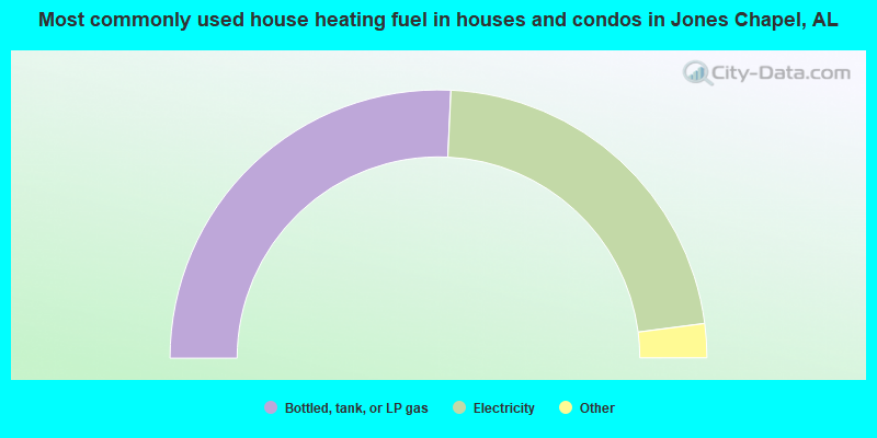
- 51.5%Bottled, tank, or LP gas
- 44.4%Electricity
- 2.1%Utility gas
- 1.6%Wood
- 0.4%Fuel oil, kerosene, etc.
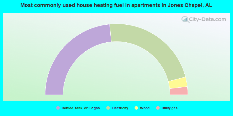
- 47.0%Bottled, tank, or LP gas
- 45.0%Electricity
- 4.4%Wood
- 3.7%Utility gas
Jones Chapel compared to Alabama state average:
- Unemployed percentage significantly below state average.
- Black race population percentage significantly below state average.
- Hispanic race population percentage significantly below state average.
- Median age below state average.
- Foreign-born population percentage significantly below state average.
- Renting percentage below state average.
- Length of stay since moving in significantly above state average.
- Number of rooms per house significantly below state average.
- House age significantly below state average.
- Number of college students below state average.
- Percentage of population with a bachelor's degree or higher significantly below state average.
Jones Chapel on our top lists:
- #76 on the list of "Top 101 larger cities with the lowest real estate taxes percentage (population 50,000+)"
- #86 on the list of "Top 101 counties with the highest number of deaths per 1000 residents 2007-2013 (pop. 50,000+)"
- #101 on the list of "Top 101 counties with highest percentage of residents voting for Romney (Republican) in the 2012 Presidential Election"